Hike.uno
Hike.uno
Login
Login
Username:
Password:
Login
Not registered yet? Registration.
Forgot password?
Trbovlje

Trbovlje

Country: Slovenia
Latitude/Longitude: 46,1558964°N 15,0540204°E
Altitude: 287 m
Type: Town
Weather forecast:
Th
Fr
Sa
Su
Mo
Description:
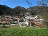
Trbovlje is a town located at an elevation of 287 meters. The town is located in country Slovenia 1. 4 km east-southeast from the center of Klek and 1. 6 km southwest from the center of Ostenk Trbovlje has 15. 500 inhabitants.
Show map
Points in the vicinity:
Detailed descriptions
Tabor (697m)
2,0 km west-northwesterly
Špicberg (490m)
2,0 km southwesterly
Klobuk (890m)
4,0 km easterly
Webcams
Trbovlje
0,2 km south-southwesterly
Mrzlica
5,4 km northeasterly
Marno
6,9 km east-southeasterly
Kum
7,6 km southerly
Šentrupert
10,7 km northerly
Panoramas
Planinski dom Vrhe (908m)
5,4 km northwesterly
Mrzlica (1122m)
5,5 km northeasterly
Ostri vrh (855m)
5,9 km easterly
GPS tracks
G. Trbovlje - St. Mary on Partizanski Peak
Posavsko hribovje and Dolenjska
Čebine - Partizanski vrh
Posavsko hribovje and Dolenjska
Trbovlje - Partizanski vrh
Posavsko hribovje and Dolenjska
Hrastnik ž.p. - Dom na Kalu
Posavsko hribovje and Dolenjska
Marno - Dom na Kalu
Posavsko hribovje and Dolenjska
Starting points
Bevško
2,8 km southwesterly
Potoška vas
3,4 km west-northwesterly
Podmeja
3,4 km northerly
Trbovlje
3,6 km south-southwesterly
Hrastnik
4,8 km southeasterly
         
Copyright © 2026 Hike.uno, Terms of use, Privacy and cookies