Hike.uno
Hike.uno
Login
Login
Username:
Password:
Login
Not registered yet? Registration.
Forgot password?
Drežnica

Drežnica

Country: Slovenia
Mountain range: Julian Alps
Latitude/Longitude: 46,2570074°N 13,6136555°E
Altitude: 550 m
Type: Village
Weather forecast:
We
Th
Fr
Sa
Su
Description:
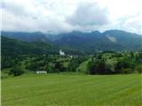
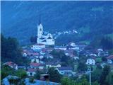
Drežnica is a village in the Julian Alps mountain range at an altitude of 550 meters. The village is located in country Slovenia 1. 5 km south-southeast from the center of Drežniške Ravne and 2 km north-northeast from the center of Ladra
Images:
Drežnica Drežnica
Show map
Points in the vicinity:
Detailed descriptions
Planica (below Krn) (1376m)
2,4 km east-southeasterly
Curk Waterfall (1115m)
2,5 km northeasterly
Bivak na Črniku (1160m)
2,5 km east-northeasterly
Webcams
Italijanska kostnica nad Kobaridom
2,5 km west-southwesterly
Kobarid
2,7 km southwesterly
Koča na planini Kuhinja
3,9 km east-southeasterly
Javoršček
6,5 km northerly
Kuk (Kolovrat)
6,8 km southerly
Panoramas
Planica (below Krn) (1376m)
2,4 km east-southeasterly
Curk Waterfall (1115m)
2,5 km northeasterly
GPS tracks
Starting points
Drežnica
0,3 km east-southeasterly
Drežniške Ravne
1,8 km northerly
Kobarid
3,0 km west-southwesterly
Planina Zapleč
3,3 km north-northeasterly
Svino
3,8 km west-southwesterly
         
Copyright © 2026 Hike.uno, Terms of use, Privacy and cookies