Hike.uno
Hike.uno
Login
Login
Username:
Password:
Login
Not registered yet? Registration.
Forgot password?
Leše

Leše

Country: Slovenia
Latitude/Longitude: 46,3541023°N 14,2553816°E
Altitude: 512 m
Type: Village
Weather forecast:
We
Th
Fr
Sa
Su
Description:
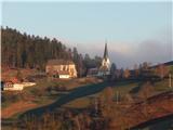
Leše is a village located at an elevation of 512 meters. The village is located in country Slovenia 0. 6 km east-southeast from the center of Paloviče and 0. 9 km south-southwest from the center of Hudi Graben
Images:
Leše Leše
Show map
Points in the vicinity:
Detailed descriptions
Vaško (1046m)
2,0 km northeasterly
Sveti Jurij above Tržič (673m)
2,6 km east-northeasterly
Gutenberk Castle (Hudi grad) (663m)
2,7 km east-northeasterly
Koča na Dobrči (1478m)
2,7 km north-northwesterly
Webcams
Brezje
3,8 km south-southwesterly
Podvin
4,1 km west-southwesterly
Tržič
4,3 km east-northeasterly
Podtabor
4,5 km southerly
Podljubelj
5,6 km north-northeasterly
Panoramas
Vaško (1046m)
2,0 km northeasterly
Gutenberk Castle (Hudi grad) (663m)
2,7 km east-northeasterly
Koča na Dobrči (1478m)
2,7 km north-northwesterly
Peračica waterfall (430m)
2,8 km southwesterly
GPS tracks
Hudi Graben - Dobrča Hut
Kamnik Savinja Alps
Slatna - Koča na Dobrči
Kamnik Savinja Alps
Tržič - Koča na Dobrči
Kamnik Savinja Alps
Starting points
Hudi Graben
0,8 km north-northeasterly
Zadnja vas
1,1 km northwesterly
Hibje
1,9 km north-northwesterly
Brezje pri Tržiču
1,9 km east-northeasterly
Peračica
2,1 km south-southwesterly
         
Copyright © 2026 Hike.uno, Terms of use, Privacy and cookies