Hike.uno
Hike.uno
Login
Login
Username:
Password:
Login
Not registered yet? Registration.
Forgot password?
Lipa

Lipa

Country: Slovenia
Latitude/Longitude: 45,8485678°N 13,7033473°E
Altitude: 381 m
Type: Village
Weather forecast:
We
Th
Fr
Sa
Su
Description:
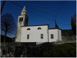
Lipa is a village located at an elevation of 381 meters. The village is located in country Slovenia 2 km east from the center of Temnica and 3 km west-northwest from the center of Škrbina Lipa has 101 inhabitants.
Images:
Lipa
Show map
Points in the vicinity:
Detailed descriptions
Stjenkova koča on Trstelj (610m)
1 km north-northeasterly
Trstelj (643m)
1,1 km northerly
Sveti Ambrož (Tabor) (531m)
1,2 km west-northwesterly
Stol (Črni hribi) (629m)
1,4 km north-northwesterly
Stolovec (563m)
2,0 km northwesterly
Webcams
Trstelj
1,0 km northerly
Renče
5,3 km north-northwesterly
Branik
6,6 km easterly
Bilje
7,2 km northwesterly
Cerje
7,3 km west-northwesterly
Panoramas
Stjenkova koča on Trstelj (610m)
1 km north-northeasterly
Trstelj (643m)
1,1 km northerly
Veliko Cerje (343m)
7,3 km west-northwesterly
Vitovski hrib (604m)
11,4 km north-northeasterly
GPS tracks
Lipa na Krasu - Trstelj
Goriško, Notranjsko and Snežniško hribovje
Prvačina - Trstelj
Goriško, Notranjsko and Snežniško hribovje
Dornberk - Trstelj
Goriško, Notranjsko and Snežniško hribovje
Renče - Trstelj
Goriško, Notranjsko and Snežniško hribovje
Starting points
Železna vrata
2,0 km northeasterly
Temnica
2,1 km westerly
Gora
2,4 km northeasterly
Črni hribi
3,5 km west-northwesterly
         
Copyright © 2026 Hike.uno, Terms of use, Privacy and cookies