Country: Austria
| Latitude/Longitude: | 46,9505037°N 14,6874552°E |
| |
Altitude: 1720 m
Type: Mountain hut
Weather forecast:
Description:
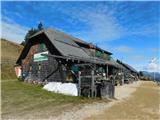
Hohenwarthütte is a mountain hut at an altitude of 1720 meters and is part of the Lavanttal Alps. The mountain hut is located 4 km north-northeast of peak Geierkogel. The nearest peak is Schwarzkogel, which is located 0.5km vzhodno-jugovzhodno. West of the mountain hut is the valley Görtschitztal.
Images:
Points in the vicinity: