Hike.uno
Hike.uno
Login
Login
Username:
Password:
Login
Not registered yet? Registration.
Forgot password?
Kobarid

Kobarid

Country: Slovenia
Mountain range: Julian Alps
Latitude/Longitude: 46,2455017°N 13,5791754°E
Altitude: 237 m
Type: Village
Weather forecast:
Th
Fr
Sa
Su
Mo
Description:
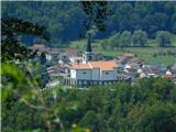
Kobarid is a village in the Julian Alps mountain range at an altitude of 237 meters. The village is located in country Slovenia 1. 7 km north-northwest from the center of Idrsko and 2 km west-northwest from the center of Ladra Kobarid has 1. 121 inhabitants.
Images:
Kobarid
Show map
Points in the vicinity:
Detailed descriptions
Mali Kozjak waterfall (230m)
1,5 km north-northeasterly
Veliki Kozjak Waterfall (250m)
1,6 km north-northeasterly
Svinska planina (1214m)
3,8 km southwesterly
Idrska planina (1250m)
4,0 km south-southwesterly
Webcams
Kobarid
0,3 km east-southeasterly
Italijanska kostnica nad Kobaridom
0,4 km east-northeasterly
Matajur
5,2 km southwesterly
Kuk (Kolovrat)
6,4 km south-southeasterly
Panoramas
Veliki Kozjak Waterfall (250m)
1,6 km north-northeasterly
Svinska planina (1214m)
3,8 km southwesterly
Idrska planina (1250m)
4,0 km south-southwesterly
Mrzli vrh (on Matajur) (1358m)
4,4 km south-southwesterly
GPS tracks
Starting points
Kobarid
0,3 km north-northwesterly
Svino
0,9 km west-southwesterly
Drežnica
3,1 km east-northeasterly
Drežniške Ravne
4,1 km northeasterly
Livek
5 km south-southeasterly
         
Copyright © 2026 Hike.uno, Terms of use, Privacy and cookies