Hike.uno
Hike.uno
Login
Login
Username:
Password:
Login
Not registered yet? Registration.
Forgot password?
Località Ladina

Località Ladina

Country: Italy
Mountain range: Julian Alps
Latitude/Longitude: 46,3605704°N 13,3592652°E
Altitude: 607 m
Type: Hamlet
Description:
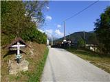
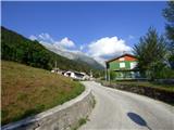
Località Ladina is a hamlet in the Julian Alps mountain range at an altitude of 607 meters. The hamlet is located in country Italy 0. 4 km east-southeast from the center of Stolvizza / Solbica and 4 km east from the center of Oseacco / Osejane
Images:
Località Ladina Località Ladina
Show map
Points in the vicinity:
Detailed descriptions
Ricovero Igor Crasso (1665m)
3,2 km north-northeasterly
Sart / Žrd (2324m)
4,3 km northeasterly
Planina Kanin / Casera Canin (1450m)
4,9 km east-southeasterly
Vrh Grubje (2240m)
4,9 km east-northeasterly
Webcams
Val Resia
2,2 km westerly
Rifugio Gilberti
8 km easterly
Kanin
8,2 km east-northeasterly
Veliki Babanski skedenj
8,2 km east-southeasterly
Kanin (Graben)
8,8 km easterly
Panoramas
Ricovero Igor Crasso (1665m)
3,2 km north-northeasterly
Sart / Žrd (2324m)
4,3 km northeasterly
Planina Kanin / Casera Canin (1450m)
4,9 km east-southeasterly
Monte Nischiuarch (1260m)
5,1 km south-southeasterly
Starting points
Ladina
0,2 km east-southeasterly
Solbica / Stolvizza
0,4 km westerly
Korito / Coritis
2,7 km east-southeasterly
Chiesetta di S'Anna
3,9 km south-southwesterly
Karnica / Sella Carnizza
4,1 km southwesterly
         
Copyright © 2026 Hike.uno, Terms of use, Privacy and cookies