Country: Austria
| Latitude/Longitude: | 47,01746°N 14,5874592°E |
| |
Altitude: 1748 m
Type: Mountain hut
Weather forecast:
Description:
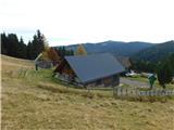
Stoanahütte is a mountain hut at an altitude of 1748 meters in the Lavanttal Alps. The mountain hut is located 5 km northeast from the center of Sankt Martin am Silberberg and 6 km west-southwest from the center of Lavantegg. The nearest peak is Zanitzenhöhe, which is located 0.9km južno. The mountain hut is located zahodno-severozahodno above the mountain pasture Streitwiesenalm. West of the mountain hut is the valley Görtschitztal and zahodno-severozahodno above the mountain pasture Streitwiesenalm.
Images:
Points in the vicinity:
Detailed descriptions
5,4 km north-northwesterly
|
|
|
Webcams
8,7 km east-northeasterly 16,0 km east-southeasterly
|
|
|
Panoramas
5,4 km north-northwesterly
|
|
|
|
|
|
|
|
|
|
|
Starting points
16,3 km east-northeasterly
|
|
|
|
|
|
|
|
|
|
|
|
|
|
|