Hike.uno
Hike.uno
Login
Login
Username:
Password:
Login
Not registered yet? Registration.
Forgot password?
Straden

Straden

Country: Austria
Latitude/Longitude: 46,8063812°N 15,8704495°E
Altitude: 367 m
Type: Village
Weather forecast:
Th
Fr
Sa
Su
Mo
Description:
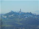
Straden is a village located at an elevation of 367 meters. The village is located in country Austria 1. 5 km east from the center of Kronnersdorf and 1. 7 km south-southwest from the center of Muggendorf
Images:
Straden
Show map
Points in the vicinity:
Detailed descriptions

6,4 km northeasterly

7,3 km east-southeasterly

8,3 km east-northeasterly

9,7 km east-northeasterly

9,7 km north-northeasterly
Webcams

0,6 km north-northwesterly

7,8 km southeasterly

12,9 km south-southwesterly

13,2 km southwesterly

16,1 km south-southeasterly
Panoramas

11,2 km east-northeasterly

12,6 km east-northeasterly

30,0 km southerly

32,1 km east-southeasterly

32,6 km southwesterly
GPS tracks


Video


Starting points

5,3 km north-northeasterly

7,0 km east-southeasterly

7,1 km north-northeasterly

8,5 km east-southeasterly

9,3 km north-northeasterly
         
Copyright © 2026 Hike.uno, Terms of use, Privacy and cookies