Non-stop riddle for beginners 2
|
| atoamac12. 03. 2011 15:55:25 |
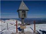
On which fortress can we admire these towers?
 1 1
|
|
|
|
| anka 12. 03. 2011 17:36:22 |
Higher, higher, what a beautiful cathedral
|
|
|
|
| atoamac12. 03. 2011 17:54:55 |
Higher, yes really, there's even a little altar on top.
|
|
|
|
| Zalas12. 03. 2011 20:04:40 |
And where is this chapel?
 1 1
|
|
|
|
| GričarA12. 03. 2011 20:20:07 |
it says below  St. Isidore St. Isidore
|
|
|
|
| Zalas13. 03. 2011 20:02:54 |
|
|
|
|
| atoamac13. 03. 2011 21:43:58 |
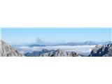
Who recognizes the most of them?
 1 1
|
|
|
|
| gmajna13. 03. 2011 23:13:52 |
in the back Struška, Vajnež, Stol, Celovška Špica;
a bit closer through the fog I see Debelo Peč and Brdo, on the right Mali Draški Vrh
below in the middle Vernar, to the left below it probably Činkelman(si orng zrezal)
|
|
|
|
| atoamac14. 03. 2011 10:05:08 |
Bravo, gmajna. On the wider picture there are also Tosc and Veliki Draški vrh.
 1 1
|
|
|
|
| šodrovc14. 03. 2011 11:45:13 |
You can see even more : on the left the bulk of Mišelj vrh, in the ridge above Pokljuka and Krma it's worth mentioning Klečica and Stresenica, behind Verner's ridge Lipanski vrh and Mrežce peek out. If we already skip individual peaks between Struška and Stol, we shouldn't omit Mali Obir, and of course Begunjščica and Košutice. Mali Draški vrh is not visible. Atoamac, it would be interesting to know where the photo was taken. I'd say on Škednjovec  . .
|
|
|
|
| atoamac14. 03. 2011 13:08:25 |
Yes, it was indeed taken on Škednjovec.
|
|
|
|
| atoamac14. 03. 2011 19:27:27 |
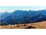
Who can recognize as many as possible?
 1 1
|
|
|
|
| viharnik14. 03. 2011 20:00:00 |
There are too many peaks to list here. The picture shows the entire Košuta ridge, where there are some 12 peaks reaching over 2000m. Then to the right are Ojstrica and Planjava, in front Košutica, below Rjavica, Sveta peč and the lower Kozji hrbet. In the first row Kosmatica. Far left Setiče, and below the forested Žerjavov praprotnik... too many to list
|
|
|
|
| Boštjan MK14. 03. 2011 20:00:42 |
I see Cjajnik, the others unfortunately I don't know
|
|
|
|
| atoamac14. 03. 2011 22:14:04 |
The entire Košuta ridge is really awkward for listing, given different maps (PZS, AMAP Austria, Geopedia), which either assign different heights to the same peaks or mark only the elevation without a name. The ridge on the left starts with bulges of Tolsta Košuta 2057 and Obličev 2026, Gamsovke not visible, followed by the peak of Košutnikov Turn 2133 or 2136, almost equally high Ostrv 2130 or 2104 and Macesje 2124, Užnik (Larchenberg) 2079, before it Cjajnik 1960, Tegoška gora (Hohe Spitze) 2044, Pungrat 2025, deep saddle Škrbina 1869, followed by Kladivo 2094, Malo Kladivo, Kofce gora (hidden by Košutica or Ljubeljska Baba), Toplar 2000 and Veliki vrh 2088. Apart from nomenclature twists, this is an extremely attractive, marked ridge traverse (V.vrh - Košutnikov Turn), while Tolsta is very visited and trampled "pathless" terrain.
|
|
|
|
| JTrogar16. 03. 2011 10:29:27 |
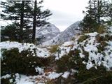
What is in the picture and from where?
 1 1
|
|
|
|
| Jure S16. 03. 2011 11:24:50 |
KSA, Kotliči... left Brana... right Turska gora...
taken from the ridge between Logarski kot and Matkov kot.
|
|
|
|
| JTrogar16. 03. 2011 13:26:24 |
The answer is of course correct, I took it under Matkovim oknom on the trail from Zabrložnica towards Okrešelj.
|
|
|
|
| Jure S16. 03. 2011 13:31:17 |
Now I'll pose one riddle too, I think it's not too hard
Which mountain is in the picture?
 1 1
|
|
|
You must log in to post a comment:
If you do not yet have a username, you must first
register.