Non-stop riddle for beginners 2
|
| ajda23. 11. 2013 09:31:27 |
|
|
|
|
| otiv23. 11. 2013 09:37:01 |
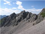
CarpeDiem247 correct .The path in the picture is from Prtovča via Povdn to Ratitovec. .The path in the picture is from Prtovča via Povdn to Ratitovec.
|
|
|
|
| CarpeDiem24723. 11. 2013 09:38:20 |
Without a hint I wouldn't have guessed, Ajda can continue or someone else.
|
|
|
|
| velkavrh23. 11. 2013 09:49:26 |
Fine, I'm just reviewing this year's recordings. This one is of course still from summer, now the winter ones will start. What is this?
 1 1
|
|
|
|
| JusAvgustin23. 11. 2013 10:08:32 |
judging by the scree, Gradovi
|
|
|
|
| velkavrh23. 11. 2013 10:30:18 |
JusAvgustin, I know no riddle troubles you. It's the Grad ridge -2008 m, which is the southwest spur of the Vrtača ridge, second highest peak of the Karawanks. Continue!
|
|
|
|
| JusAvgustin23. 11. 2013 10:52:10 |
no no you go ahead. I have obligations. But I'll peek anyway...
| (+1) |  | |
|
|
|
|
| otiv23. 11. 2013 11:28:54 |
Well, let's go a bit into the cave world, but where can we see this beautiful waterfall?
 1 1
|
|
|
|
| ledo8423. 11. 2013 11:59:11 |
Hi guys, can I get some help with this riddle?
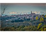
Sorry for jumping the queue....Taken near Buje (Istria) towards the west. What are these 2 left peaks?
 1 1
| (+2) | | |
|
|
|
|
| robi1423. 11. 2013 14:07:39 |
@ledo84:
I think the left one is Mt. Durano, then Antelao and Cima dei Preti...
If these are the peaks, distance is 140 - 150 km from the viewpoint... 
| (+2) | | |
|
|
|
|
| milesdavis23. 11. 2013 15:22:11 |
Last winter I saw from Vrsar Civetta, Pelmo and Antelao. They were nicely visible and really stood out from the Dolomites backdrop. So Antelao probably isn't on this picture, but super photo.
| (+2) | | |
|
|
|
|
| cico23. 11. 2013 15:56:56 |
Oti, the waterfall is there where the devil has
his home
|
|
|
|
| otiv23. 11. 2013 16:05:19 |
@cico, that will hold up, but during your visit to the devil it couldn't be seen...
|
|
|
|
| jedriličar23. 11. 2013 16:36:51 |
ledo84: if you know the approximate position from which you took the photo, put it on google earth, draw a line through Buje (as far as I see, it goes over the cemetery) and find those peaks ... very simply 
| (+3) | | |
|
|
|
|
| robi1423. 11. 2013 16:55:36 |
| (+2) | | |
|
|
|
|
| milesdavis23. 11. 2013 17:47:13 |
Yes, it's Antelao, bravo Robi.
| (+1) | | |
|
|
|
|
| otiv24. 11. 2013 10:07:57 |
Does the water flow into the Adriatic Sea?
|
|
|
|
| cico24. 11. 2013 10:16:34 |
Yes, but not directly!
|
|
|
|
| cico24. 11. 2013 10:45:58 |
Let me help, it's under the cliffs and the plateau
of Trnovo Forest, and translate that distorted thing
into Slovenian, and victory is yours!
|
|
|
You must log in to post a comment:
If you do not yet have a username, you must first
register.