Potoška planina 1270 m a.s.l.
|
| heinz23. 04. 2009 18:56:20 |
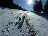
Yesterday in really nice weather I set off on an unmarked, interesting path not described here from Koroška Bela via Malnež, Spodnje Rovte and Obešnik to Potoška planina, and a bit further to Zgornje Rovte and back. It's a very interesting direction, as you can visit 4-5 beautiful locations or viewpoints at the same time.
Today the weather conditions are a bit different, as it's snowing on Potoška and higher, but tomorrow spring atmosphere will prevail again. The impression in nice weather in this early spring period is encouraging, so I recommend visiting all the pastures!
|
|
|
|
| heinz20. 09. 2011 21:18:12 |
Obešnik. Today I visited this gem above Koroška Bela, to which no direct trail leads - unfortunately or thankfully. I wanted to go up via Kozji hrbet but turned right earlier into the valley between Malnež and Obešnik where the path ends higher too. But to the first attractive horns on the left under Obešnik it's not far. At the edge of the first rocks a demanding (west) path shows up to the highest tooth with the cross. Wind in strong gusts. Ascent to the top without protection is off. After hard descent I traverse east to the other side, remember old wires. Those not (anymore) found. So I reached only ~8m below summit.
Then along the ridge to Obešnik top and down the same valley.
Nice, windy day. Over 1000 much colder.
|
|
|
|
| Majdag21. 09. 2011 09:41:40 |
Hi Heinz, I always find some new challenge with you. And I don't even know where it is, and there's even a cross up there, (another bone to gnaw), čav ! !
|
|
|
|
| heinz12. 01. 2012 18:19:33 |
Majda, beautiful pictures that cause longing.. At this time I sorely lack time for mountains.., -this way one only realizes what is most valuable in life! Without mountains you're disabled. Best, H!
| (+1) |  | |
|
|
|
|
| Majdag12. 01. 2012 19:05:57 |
Thanks Heinz, it's not far, and Reksy will be happy too...
 1 1
| (+2) | | |
|
|
|
|
| heinz4. 03. 2012 19:16:03 |
You can also climb to Malnež via the rocky ridge. The path is demanding and mostly crumbly. Today: mostly dry. Continuation to Obešnik, Nadobešnik, Potoška planina. Also here almost no snow anymore. Back: Spodnji Rovti, marked path Valvasor - Kor. Bela.
| (+2) | | |
|
|
|
|
| Majdag11. 01. 2013 13:51:13 |
...Nice as always. Drove by car to the junction - Valvasor, Potoška planina. Road mostly dry, a bit icy at some bends, but no problems. Jureg, if it helps you, probably the same to Valvasor
| (+3) | | |
|
|
|
|
| andi29. 03. 2017 10:50:05 |
Yesterday in wonderful afternoon sun loop Smolnik-Ajdna-Spodnji Rovti-Potoška planina. Beautiful views, so the camera stayed in the pocket. Path from Spodnji Rovti marked with orange Zs, softened snow at pasture height and towards Valvasor still persists. Path descriptions on the portal are well written. Probably soon another visit due to many beautiful locations listed above
|
|
|
|
| Majdag15. 04. 2017 16:40:37 |
| (+3) | | |
|
|
|
|
| zlatica15. 04. 2017 16:54:16 |
Majda, your sense for stories with beautiful photos doesn't dry up - to my joy..
| (+1) | | |
|
|
|
|
| Majdag16. 04. 2017 09:37:07 |
... Zlatica, life is a novel that we write ourselves. Every day is a new story, only the last pages cannot be concluded. Keep enjoying, thanks.
| (+1) | | |
|
|
|
|
| jbs22. 04. 2018 21:45:15 |
On Saturday we did a loop from Koroška Bela via Potoška planina. We went up the path to Ajdna and Valvasor and via Spodnjih rovtov first to Potoška planina. Then we returned via Pristava - Valvasor path. From that path we wanted to branch off to the so-called Gajškova pot. When we branched off, after some 100m we hit a fenced rovti and locked gate blocking the path ahead. So we turned back, descended to the road and went back to Koroška Bela by road. Wondering if the branch from Pristava - Valvasor to Gajškova pot is higher? Also: upper part of Pristava - Valvasor path where it joins forest road below Stamare planina has many fallen trees, a bit harder to pass (cleaning underway).
| (+1) | | |
|
|
|
|
| heinz23. 04. 2018 20:39:51 |
| (+1) | | |
|
|
|
|
| jbs23. 04. 2018 21:29:27 |
Ah so, thanks. If I understand correctly, the branch is even lower than where we first turned, and we obviously missed it. So Gajškova pot goes under the fenced rovta? Or is the path I marked green on the picture not the right one and goes too high?
 1 1
|
|
|
|
| heinz24. 04. 2018 06:03:32 |
|
|
|
|
| jbs24. 04. 2018 08:37:00 |
Many thanks for all explanations, next time we'll be more attentive.
|
|
|
|
| Majdag2. 05. 2018 15:59:24 |
| (+3) | | |
|
|
|
|
| zlatica2. 05. 2018 16:19:34 |
Majda, as always your avriklji are the most beautiful But aren't they especially rich this year or does it just seem so to me?
| (+1) | | |
|
|
|
You must log in to post a comment:
If you do not yet have a username, you must first
register.