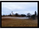
Saint Lovrenc above the village of Okroglice
|
| geppo21. 12. 2007 10:26:48 |
Photo in the early morning from the 14th Division hike February 2007 Geppo
 1 1
| (+2) |  | |
|
|
|
|
| Guest21. 12. 2007 12:38:16 |
|
|
|
|
| Guest21. 12. 2007 12:54:06 |
Wonderful shot!
|
|
|
|
| Guest21. 12. 2007 17:04:33 |
Yes, of course every year the Society for Preserving the Memory of the 14th Division March organizes this hike. This hike lasts 3 days and is cck. 70km route length. Organizers are from Laško and I have already participated 4x. Every year I say last time - every year I join - problems are only winter. The hike is in memory of crossing the Sotla river at Sedlarjevo (Podčetrtek) and goes to Gračnica valley (Rimske Toplice). Food, accommodation, everything is well organized and always nice. That's why I regularly participate since I learned about this hike. The hike is joined by cck. 150 hikers every year and some of us are already old acquaintances!!
Geppo
|
|
|
|
| Guest21. 12. 2007 21:27:49 |
Thanks for the reply and for the photos.
|
|
|
|
| geppo1. 02. 2008 16:40:57 |
I'm interested if any of you will join the three-day hike (7.2.08 - 9.2.08)
ON THE PATHS OF THE XIV. DIVISION
SEDLARJEVO - GRAČNICA VALLEY
LP
|
|
|
|
| geppo17. 01. 2009 20:58:51 |
|
|
|
|
| aljoša123. 04. 2009 14:50:40 |
Does anyone know if gentians are already blooming on Lovrenc? How is Gašperjeva hut open?
They say it's open only on Sundays, but with holidays is it different? If someone is hiking around there, ask?
|
|
|
|
| bP27. 04. 2009 08:31:40 |
Gašperjeva hut was closed yesterday 26.4.2009. Gentians on Lovrenc are already blooming.
regards
bP
| (+1) | | |
|
|
|
|
| Bbrina11. 05. 2016 07:19:59 |
The ridge on the last picture is really visible from the road and very inviting. Again a good idea for a hike and really wonderful photos of the flowers. You had a good time, no doubt.
| (+1) | | |
|
|
|
|
| geppo11. 05. 2016 16:09:05 |
This ridge is so untouched... Probably only chamois claim it and enjoy their peace above the sheer cliffs. Need to repeat it to remember the key points...
regards
|
|
|
|
| Enka11. 05. 2016 17:11:10 |
This is a nice idea. To imitate. How much elevation gain (so I can calculate how long I'd need  )? )?
|
|
|
|
| geppo11. 05. 2016 20:13:54 |
Enka
a bit over 2000m. Nice tour with a beautiful finish. The ridge isn't difficult, but quite wild with nice views of sheer cliffs and the Savinja far below...
regards
| (+1) | | |
|
|
|
|
| garmont11. 05. 2016 20:52:35 |
Great, but that much elevation gain? 
Or is it?
|
|
|
|
| geppo11. 05. 2016 20:55:52 |
No Garmin. The track was drawn by Endomondo and ...that's what it says? We sweated quite a bit up/down...all eight hours.
regards
| (+1) | | |
|
|
|
|
| kolpa24. 03. 2017 22:49:20 |
On the 13th and 14th photos there is a spring plant called dog's tooth from the lily family.
| (+2) | | |
|
|
|
You must log in to post a comment:
If you do not yet have a username, you must first
register.