|
| magroman29. 04. 2026 15:00:51 |
Hello,
Is the hut open?
Regards,
Roman
|
|
|
|
| ppegan29. 04. 2026 20:40:00 |
I don't think so. The hut will be closed in May (check PD Kranj page), so I doubt it'll be open tomorrow if it's closed the whole of May. The hut below Storžič will be normally open for the weekend though.
|
|
|
|
| MarkoStegnar2230. 04. 2026 10:16:10 |
How are the marked trails on Storžič?
Southern side - Bašelj / Mače looks pretty bare, but I'm interested in the northern side too - Dom pod Storžičem. Škarjev rob and Žrelo are quite snowy, what about the southwest gully?
Is it possible without heavy winter gear (ice axe/crampons)?
|
|
|
|
| Norge5. 05. 2026 07:43:19 |
I'm also interested in what the path from the starting point Povlje is like, has anyone been up that path in the last few days?
|
|
|
|
| ppegan5. 05. 2026 09:21:27 |
Regarding the snow, this photo might help, but it's really quite zoomed in.
 1 1
| (+2) |  | |
|
|
|
|
| palček plezalček12. 05. 2026 22:22:22 |
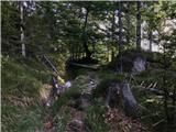
My Sunday exploration starts in Laško (above Bašelj), where there's a large parking lot designated for hikers.
After a few minutes, I turn onto a quasi-path that should lead to a marked trail a bit higher up. I did reach it, but instead of following the path, I hugged a couple of trees to manage a few dozen meters of elevation in the 'upright lying' forest. Continuing brings me to a bench by the spruces, where the path branches left toward Planina Javornik and right toward Kališče. You go straight ahead if you continue along the unmarked but well-trodden SW ridge of Storžič. This time I followed the path to the right, but left it among the first beeches in search of a hunting bivouac. Not much searching was needed, as with a slightly more attentive glance, you can spot it right from the path. One-two, I'm there, and peeking through the window, I spot a metal box from some bygone era standing on a table covered in leaves. Next to it is a stove. In front of the hut, there are scattered bottles; behind it, a path should reveal itself that would lead me higher to the SW ridge. I zigzag along the slope and, although I don't encounter the path, with beautiful views some 300 m higher, I step onto the ridge, where I start chasing the fog. When I finally catch up to it, voices join in. At the summit, quite a few enthusiasts are sitting in the cold and wind. They're probably waiting for the sun's return or simply can't give up the habit of lounging at the mountain's highest point despite the chill.  I didn't join them in waiting; instead, frozen, I hurried off to Bašeljsko sedlo, scanning along the way for a branch-off that tempts me for some future time. From the saddle, sharply right to catch the path, on which a bit lower I stumble upon a marked spring. Then I traverse the slope along a well-visible trail toward Kališče, but at the right spot turn right and continue along a sometimes less visible but picturesque path, where I even encounter two not very talkative mouflons. I step back onto the marked trail at Planina Spodnje Kališče. From there toward the partisan hospital and back to civilization. I didn't join them in waiting; instead, frozen, I hurried off to Bašeljsko sedlo, scanning along the way for a branch-off that tempts me for some future time. From the saddle, sharply right to catch the path, on which a bit lower I stumble upon a marked spring. Then I traverse the slope along a well-visible trail toward Kališče, but at the right spot turn right and continue along a sometimes less visible but picturesque path, where I even encounter two not very talkative mouflons. I step back onto the marked trail at Planina Spodnje Kališče. From there toward the partisan hospital and back to civilization.
 1 1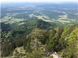 2 2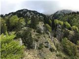 3 3 4 4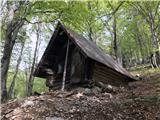 5 5 6 6 7 7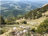 8 8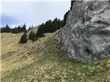 9 9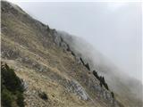 10 10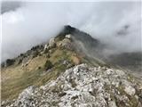 11 11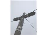 12 12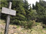 13 13 14 14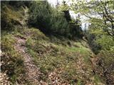 15 15 16 16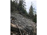 17 17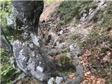 18 18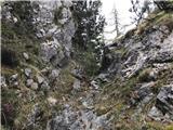 19 19 20 20 21 21
| (+11) | | |
|
|
|
|
| ppegan13. 05. 2026 09:00:02 |
Palčica, you really don't lack the exploratory spirit Super, nice hike, and a slightly different approach to Storžič 
|
|
|
|
| tango13. 05. 2026 09:09:52 |
Hi, just curious where you join the path from Kališče to Javornik when descending from Bašeljsko sedlo. Orientation-wise relative to the spring?
|
|
|
|
| pantharej13. 05. 2026 10:13:48 |
From the map I see that you know the paths in the Storžič area well. From the south side, however, you are still missing two. The first one starts in Bašelj. You go along the Gamsova path to Gradišče. At the top of the hill where the road levels out, you turn left into the steep slope. The poorly visible trail is only at the beginning. The path gradually goes to the right, but when you come out of the forest into the grassy gully, the path disappears. Here you can go straight up steeply through the grass or along game trails into the forest and up on your own. You reach the marked path somewhere near that bivouac. The second path you have in zs
 1 1 2 2
| (+1) | | |
|
|
|
|
| ppegan13. 05. 2026 10:56:43 |
@tango, if I'm not mistaken, you come out right at the spring or very close.
| (+1) | | |
|
|
|
|
| palček plezalček13. 05. 2026 12:56:11 |
Ppegan, thanks. If there was more time, it would be even more fun, but this way you catch the moments when you can.
Tango, when you descend from Bašelj Saddle, the path isn't immediately visible, but you quickly pick it up further to the right looking down. You can already see it well on the first lower picture. When you spot a small grove ahead (I think mostly spruces), to the left of them you also notice the sign for the spring (second picture below). Third picture - approximate drawing on maPZS.
By the way, on Google Maps or Google Earth, what's supposed to be the remainder of the path from the bivouac upwards to the ridge is drawn differently than on maPZS.
| (+1) | | |
|
|
|
|
| palček plezalček13. 05. 2026 13:00:01 |
Pantharej, thanks. I'll try sometime to find the path and its end from your pictures.
|
|
|
You must log in to post a comment:
If you do not yet have a username, you must first
register.