Aljažev dom v Vratih - Triglav (Tominšek route)
Starting point: Aljažev dom v Vratih (987 m)
| Latitude/Longitude: | 46,41280°N 13,84660°E |
| |
Route name: Tominšek route
Walking time: 6 h 10 min
Difficulty: very difficult marked way
Via ferrata: B
Elevation gain: 1877 m
Elevation difference along the route: 1930 m
Map: Triglav 1:25.000
Recommended equipment (summer): helmet, self belay set
Recommended equipment (winter): helmet, self belay set, ice axe, crampons
Views: 382.652
 | 17 people like this post |
Access to starting point:
We drive to Mojstrana, then follow the signs for Vrata valley. We continue driving along the toll road, which is closed to public traffic in winter, following it to the large parking lot located a few minutes before Aljažev dom v Vratih.
Route description:
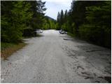
From the large parking lot, we continue along the road closed to public traffic, along which we reach Šlajmerjev dom in a few minutes and a little further Aljažev dom v Vratih.
In front of Aljažev dom, the path to Škrlatica branches off to the right, but we continue straight towards Triglav, Luknje, Pogačnikov dom na Kriških podih and numerous other destinations along a wide path that takes us into the forest after the chapel, and further on it is quite gentle.
We continue past the winter bivouac, and when we leave the forest, we arrive at the famous memorial plaque in Vrata valley, dedicated to the fallen partisan mountaineers.
Here we leave the wide gentle path that continues towards the head of the valley and continue left towards Tominškova pot. We proceed through scree into the forest, where we begin to ascend along a well-maintained path that is quite steep and has wooden steps in some places to assist us. After a little more than an hour and a half of steep path, the forest begins to thin and we reach the start of the climbing section of the path, where the first fixed protections assist us.
Further on, the path becomes increasingly precipitous and exposed to falling rocks, gradually transitioning from the slopes of Rjavčeve glave to the slopes of Begunjski vrh. The climbing section of Tominškova pot mainly leads us in a traverse ascent to the right, though sometimes we ascend quite steeply upwards with the help of protections.
Above 2000 meters above sea level, the path gradually becomes less demanding and we join the path leading over Prag, and a little further we arrive at Begunjski studenec.
We continue steeply ascending, though technically not demanding on this section, and after about 15 minutes of further walking, we reach the next junction, where the path to dom Valentina Staniča pod Triglavom branches off to the left, but we continue straight and follow the signs to Triglav and Triglavski dom na Kredarici.
The path ahead temporarily flattens a bit, bypasses Kotel on the right side and passes to Triglavske pode, where orientation is somewhat difficult especially in fog. On the upper part of Triglavske pode, the path becomes steeper again and technically demanding, with protections assisting on the more difficult sections.
Once we ascend above the steep part, the path flattens again and with increasingly beautiful views, we ascend to Triglavski dom na Kredarici in a few minutes of further walking.
We continue right towards Triglav (sharply left to Kredarica peak and Kot valley, left to Krma valley and Pokljuka) and descend to Ledeniški preval along a technically undemanding path, from where we begin ascending towards the ridge of Mali Triglav. Here we follow the markers and the large marker visible from afar, near which the very demanding path to Triglav begins.
Initially, we ascend a not yet very steep slope with the help of a few pegs and individual fixed cables, but when we reach the ridge of Mali Triglav, we begin traversing upwards to the left, where fixed cables were added to the pegs a few years ago to allow self-belaying with a via ferrata set. There follow some quite steep and exposed ascents, where we must be careful not to slip, and on the section with loose rocks, we must also be careful not to dislodge stones as this can be deadly dangerous for hikers below us. The path ahead is quite narrow and with a larger number of visitors, congestion can occur due to difficult passing between hikers.
Higher up, the steepness eases and from the left, the path from Dom Planika pod Triglavom joins us, specifically the path over Mali Triglav, which we reach a little further on.
From Mali Triglav, there is a slight descent along an occasionally less exposed ridge, and when we begin ascending again, the ridge narrows and the path becomes precipitous on both sides. Further on, there are some quite steep ascents, the path is mainly well protected with fixed cables and individual pegs, and on nice days, congestion is possible due to passing until the summit. Below the summit, the path becomes less demanding but still precipitous. Just below the summit, the path to Staničevo zavetišče (emergency bivouac carved into the Triglav massif) branches slightly to the left, but we follow the still cautious but last few meters less steep path to Aljažev stolp, located on the summit of Triglav, the highest peak of the Julian Alps and Slovenia.
Starting point - Aljažev dom 0:05, Aljažev dom - Kozja dolina 1:50, Kozja dolina - Begunjski studenec 1:45, Begunjski studenec - Kotel 0:15, Kotel - Triglavski dom na Kredarici 1:00, Triglavski dom na Kredarici - Ledeniški preval 0:05, Ledeniški preval - Mali Triglav 0:35, Mali Triglav - Triglav 0:35.

Photos:
 1
1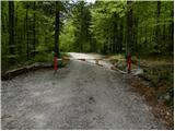 2
2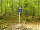 3
3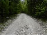 4
4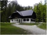 5
5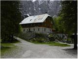 6
6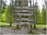 7
7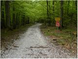 8
8 9
9 10
10 11
11 12
12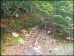 13
13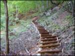 14
14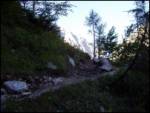 15
15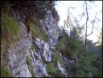 16
16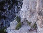 17
17 18
18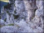 19
19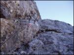 20
20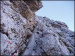 21
21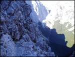 22
22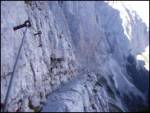 23
23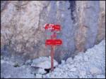 24
24 25
25 26
26 27
27 28
28 29
29 30
30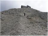 31
31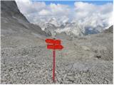 32
32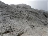 33
33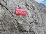 34
34 35
35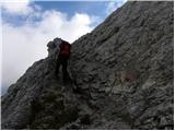 36
36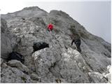 37
37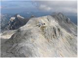 38
38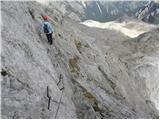 39
39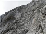 40
40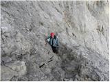 41
41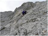 42
42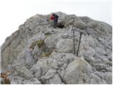 43
43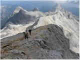 44
44 45
45 46
46 47
47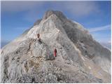 48
48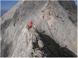 49
49 50
50 51
51 52
52 53
53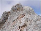 54
54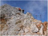 55
55 56
56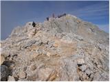 57
57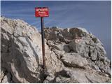 58
58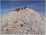 59
59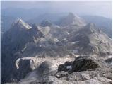 60
60 61
61
Discussion about the trip Aljažev dom v Vratih - Triglav (Tominšek route)
Show older messages
|
| Gost26. 09. 2006 |
GREETINGS;
I AM A HIKER FROM MARIBOR AND I AM INTERESTED IF THE TOMINŠKOVA ROUTE IS STILL SUFFICIENTLY SAFE AT THIS TIME AND AT WHAT HOUR I SHOULD START FROM ALJAŽEV DOM TO REACH THE SUMMIT IN ONE DAY AND THEN BACK TO THE VALLEY. I AM ALSO INTERESTED, GIVEN THE WEATHER CONDITIONS, IF THIS WEEK IS STILL SUITABLE FOR THE TRIGLAV ROUTE. I WOULD TAKE THIS ROUTE FIRST, OTHERWISE I HAVE ALREADY BEEN TO THE SUMMIT 5 TIMES, EVEN VIA PRAG. THANKS IN ADVANCE FOR THE ADVICE AND NICE MOUNTAINEERING GREETINGS.
SANDI FROM MARIBOR
|
|
|
|
| Tadej26. 09. 2006 |
The path is significantly more difficult than the one via Prag, but if you're not afraid of precipices and are experienced on climbing routes, it's relatively safely passable since the safety gear on the path was renovated this year. It's still possible in one day if you start from the car a little before 6:00, so that it gets light by the time you reach the difficult part. But know that it's dark by 19:00. You can return via Prag. LP
|
|
|
|
| Gost26. 09. 2006 |
THANKS FOR THE EXPLANATIONS TADEJ.
LP
SANDI
|
|
|
|
| Gost26. 09. 2006 |
Tominškova path: pleasure from start to finish. Excellent safety gear. Adrenaline works. Almost no (4)hikers. Beautiful, sunny, not hot, beautiful autumn tour. Recommended!
|
|
|
|
| david16. 10. 2006 |
I went on Sunday via Tominškova path. I started at 6:45 when it was still dark. The path is well secured, just caution needed on some sections due to frozen snow. It was sunny and cold. In other words, unforgettable
|
|
|
|
| Gost22. 03. 2007 |
I really really want to go to Triglav which is my favorite mountain and I promise I'll go one day because I'm very interested in mountains in Slovenia     
|
|
|
|
| Gost21. 04. 2007 |
is it safe via Tominškova in this season?
|
|
|
|
| Gost21. 04. 2007 |
I hiked this path last summer when it was dry and I think it's very dangerous in this season.
|
|
|
|
| Gost23. 04. 2007 |
Last week (14.4.2007) I went down Tominškova. You need to be quite experienced and careful, as the snow is southern-facing and collapses. A slip happens quickly on such rotten snow.
|
|
|
|
| alen_32419. 05. 2007 |
What is the condition on Tominškova trail, what equipment is needed (crampons, ice axe, rope...)?
|
|
|
|
| Gost19. 05. 2007 |
Currently crampons, ice axe and helmet are needed, I recommend visit about a month later. Perhaps ascent via pathless valley behind Cmír which is not technically difficult.
|
|
|
|
| Gost23. 07. 2007 |
Is the path suitable for me? I am 13 years old and quite experienced.
|
|
|
|
| Gost23. 07. 2007 |
Those with whom you will go will best judge and assess that. But don't go alone, even though you have some experience. Use them for much less demanding tours. Go well and enjoy.
|
|
|
|
| Gost3. 08. 2007 |
Hello! I'm interested in the current conditions on the Tominškova route, because I'm going to Triglav soon. I'd be glad if I get a reply as soon as possible. LP Poldi
|
|
|
|
| Gost3. 08. 2007 |
For an experienced mountaineer the conditions are ideal. Helmet is mandatory.
|
|
|
|
| Gost7. 08. 2007 |
On Saturday I'm going to Triglav for the first time via Tominškova path. Is it more demanding than the path to Prisank?
|
|
|
|
| Rok7. 08. 2007 |
I think it is more demanding than the one going to Prisank from the southern side.
Approximately as demanding as the ridge path and easier than all other paths to Prisank.
|
|
|
|
| Gost7. 08. 2007 |
Thanks for the information
|
|
|
|
| Gost7. 08. 2007 |
Does anything else kick you in the ass?
|
|
|
|
| Gost7. 08. 2007 |
It's good to have some chain with you. Last time I had to lower my buddy with a sweater because I had nothing else. I tied a bag to the end of the sweater with an apple in it. I think it hit him pretty good. Anyway, let him tell how it was.
|
|
|
|
| Gost13. 08. 2007 |
Is a helmet really mandatory if you go via Tominšek's path? More than 20 years ago I went twice on it and had no problems. Are there perhaps many more hikers in the mountains who can dislodge a stone onto your head?
|
|
|
|
| Gost13. 08. 2007 |
Helmet and good shoes are nowhere necessary. Without a helmet and in flip-flops you can reach Triglav too. But it's enough to notice once that they are needed. Because you usually don't get another chance... It's right to go to the mountains with a helmet if there's a wall above you. No need for hikers, nature itself crushes stones, sometimes there's a mischievous chamois that we get on its nerves (the last one shot at me right below Luknja), or you just lean a stick against a stone. It's not hard to have a helmet on your head, and you'll set a good example.
|
|
|
|
| Gost13. 08. 2007 |
Thanks. Nice day, Miran
|
|
|
|
| Gost15. 08. 2007 |
Hi, I need advice. I'm going to Triglav for the first time on 8 and 9 September via Tominšek's path and I'm wondering about equipment. Can hiking Adidas Nikes with Vibram sole work or do I need mountaineering boots? Is the path difficult?
|
|
|
|
| Gost16. 08. 2007 |
Dear God, low hiking Adidas really don't belong in the mountains, especially not in high mountains. High cut is needed primarily to protect your ankle. Read a good description of the path to Triglav (also via Tominšek) in T. Mihelič's guidebook: Julian Alps. For starters: Tominšek's is marked as a very demanding path. If you're going to Triglav for the first time, better start from Pokljuka via Velo Polje. Good luck!
|
|
|
|
| Gost17. 08. 2007 |
we are going with an experienced alpinist
|
|
|
|
| Gost17. 08. 2007 |
A real alpinist will send you home already in Vrata if you don't have the right equipment...
|
|
|
|
| Gost17. 08. 2007 |
Just these days I was on Triglav for the first time via this path. Despite lacking climbing experience, the path was not too difficult. I recommend using a helmet, high boots are basic equipment for such a path.
But you shouldn't be afraid of heights (or just don't look down too much ), some fitness is essential and perhaps a little practice climbing secured paths.
Good luck and once you're up there - no rush, better safe and later!
|
|
|
|
| Gost18. 08. 2007 |
I'm interested which is the easiest path to Triglav
|
|
|
|
| Gost18. 08. 2007 |
The easiest to me seems Krma (or Pokljuka), Planika, Mali Triglav, Triglav. Also from Dolič is similarly difficult. Other paths are harder. Regards Tarzan.
|
|
|
|
| Gost24. 08. 2007 |
I'm interested in what the path to Triglav via Tominškova is like for the first time?
|
|
|
|
| Gost24. 08. 2007 |
Hello, self-belaying equipment is mentioned. Is it actually recommended (necessary?) in addition to the helmet for this path? Thanks for the answer and good luck!
|
|
|
|
| Gost25. 08. 2007 |
Do they rent out self-protection gear and helmets anywhere?
(Gorenjska area)
Thanks for any response.
|
|
|
|
| Gost26. 08. 2007 |
I was there for the first time recently and went up Tominškova then down through Plemenice... helmet mandatory...
|
|
|
|
| Gost26. 08. 2007 |
are you completely nuts going to Triglav in sneakers no god would get me up Triglav without mountaineering boots and helmet.
lp
|
|
|
|
| Gost27. 08. 2007 |
Buy yourself a helmet, you'll need it when you're tumbling in the mountains. You'll wear your "švic" on your head, and won't get any bumps either. It's not such a big expense, better than "appetizers". Greetings Liza
|
|
|
|
| Gost27. 08. 2007 |
If you are not afraid (I was very much) of heights, this trail is very suitable because it is not physically demanding, to Kredarica my partner and I needed 4 hours of slow walking. Similar feelings as when climbing to the top of Triglav.
For the return we thought it would be easier via Prag, but I suffered even more, and the trail seemed endless. Dragica (47 years)
|
|
|
|
| Gost3. 09. 2007 |
Hi to all mountaineers who have already been to Triglav or will decide to conquer it. On Saturday I went to Triglav for the first time via Tominšek's route, and back via Prag. I have quite a few two-thousanders conquered, but I think some take our daddy too lightly.
At the top it's a real party and you notice all sorts of things. From old grannies with a tremendous desire to reach the top, regardless of being dizzy, to children not properly equipped and dad going in sneakers with laces undone, to wild young guys who think the whole world is theirs and more... some take the path too lightly. Triglav is truly beautiful and good that there aren't more accidents yet, because some are so careless. Tominšek's is a demanding path and without fitness you can't do it, you always have to think that when you're at the top, the return to the valley awaits. So use your head and safe steps, because the mountain isn't crazy, nor is the one who goes up. Many more mountaineering pleasures. and safe steps.
|
|
|
|
| Gost4. 09. 2007 |
I quite agree with this description of the situation on Triglav and around it. That's why I've been avoiding it for many years. Maybe that's not entirely right. The best times were at Kredarica when it was still the old hut and there wasn't (especially compared to today) excessive crowds on Triglav. But my dear Slovenes always have the desire that at least once you have to go up and if you don't go to Triglav, you're not in the mountains at all. And there are so many beautiful mountains (high and a bit less high) in our little country. So to all who love more solitary paths and "just right" mountaineers, seek out these gems. You won't regret it. Good luck!
|
|
|
|
| Gost5. 09. 2007 |
I'm interested in what the conditions are like now after this last weather deterioration. Do you think it'll be possible to go up this path on Friday?
|
|
|
|
| Gost5. 09. 2007 |
I'm also interested what the conditions will be like this weekend, I planned to go up Saturday but now I'm rethinking if it's even worth it, tomorrow they forecast snow line above 1300 m a.s.l.
I plan to go up Tominškova.
regards
|
|
|
|
| Gost13. 09. 2007 |
Super path and magnificent mountain 2.45h to summit
|
|
|
|
| plezalec11. 09. 2008 |
Oh!
If anyone has walked parts of it, I'm interested in what it looks like, as I plan to go on it.
Thanks!
|
|
|
|
| jersy22. 09. 2008 |
how can this path be compared to the Slovenian one on Mangart or Hanz's on Mojstrovka..especially up to the part where the path joins the path over the threshold?
thanks
|
|
|
|
| the dancer29. 09. 2008 |
So on Sunday I went from Aljaž along Tolminškova via Begunjska vrata to Kredarica and directly to Triglav, back to Planika and under Triglav walls to Kredarica, descent to Begunjska vrata and via Prag to Aljaž, total 9.5h for a bit faster 
90% of Tolminškova is dry, at the end it was a bit icy, just enough that the step is not secure and you have to watch out, possibly the sun has melted it today.
The climbing path from Kredarica is quite icy and snowy, up it went okay, down I chose a slightly easier and especially drier one to Planika. Well snow on Kredarica and Triglav up to 30 cm, I was rewarded with sun on the summit
|
|
|
|
| NEIC00830. 09. 2008 |
Tolminškova path.
|
|
|
|
| Jolbe5. 10. 2008 |
Which period is best for Triglav via Tominškova? I'm 15 years old and craving adrenaline...went to Prag and it was too easy for me...well conditioned and good gear is no problem
|
|
|
|
| jersy5. 10. 2008 |
now quite some snow has fallen so I think better to visit it next year in summer or early autumn!
Regards GOOD LUCK!
|
|
|
|
| fpetel15. 10. 2008 |
In winter in good conditions from Krma past Kredarica. And at least to Kredarica it can be nice, if no conditions further. Otherwise: Triglav in winter time is a climbing tour!
|
|
|
|
| matjazD6. 10. 2008 |
From Krma past Kredarica or via Planika (somewhat easier path, exposed - snow melts earlier), but the hut is mostly closed in winter.. Good luck
|
|
|
|
| priki9. 07. 2009 |
I'm going this weekend to Triglav via Tominškova pot and I'm wondering if there's still any snow on the trail and how fit you need to be condition-wise. regards
|
|
|
|
| triglavski9. 07. 2009 |
There might still be some snow in some gully, from the junction to Staničevo onwards it's mostly all under snow. As for fitness, it's good to have enough to get up, how much that is everyone knows themselves, just look back a bit and you'll see where you've been this year, how you walked etc.
|
|
|
|
| jesenice.nadvp10. 07. 2009 |
I'm wondering if anyone is hiking to Triglav this weekend to provide info on trail conditions. On Tuesday 14.07.09 I plan to go from Vrata via Luknja and Plemenice to Triglav, back via Tominšek route or via Prag. Whoever hikes this, please share info.
|
|
|
|
| firealarm14. 07. 2009 |
jesenice.nadvp, if you happened to go to Triglav today (14. 7. 2009) and returned the same day, I would ask you for information about the conditions. I plan to go via Tominškova gor and down through Prag.
Thanks, best regards
|
|
|
|
| jesenice.nadvp14. 07. 2009 |
No, today instead of Triglav I went to Mangart.
|
|
|
|
| Nina Malina25. 07. 2009 |
Towards the summit, before Tominškova pot joins the path over Prag, there is still some snow left, which is dangerous to cross straight across. Safer passage is a bit higher, under the snow.
|
|
|
|
| cliffhanger30. 07. 2009 |
I'm 13 years old and next week we're going to Triglav via Tominškova path. I wonder if it's suitable for me. I've already been to:
Mangart (via Slovenian)
Triglav (from Krma valley)
Raduha (via very difficult marked path)
Peča (via difficult path)...
IN SHORT I LIKE "cables" and steep and high mountains
|
|
|
|
| domoljub30. 07. 2009 |
If what you wrote last is true, then you shouldn't have problems on this path. The only part that got on my nerves was shortly after the cables start, namely that part is steep, strewn with small pebbles so that it slips badly. And there's nowhere nice to hold on. And maybe some exposed ledge, but in reality it's not as bad as on the picture in the description. Otherwise I recommend a helmet (at the start of the cables you cross a wall and something might easily fall down, and later you might easily get hit on the head) and maybe gloves. I didn't need a self-belay kit, but it's also recommended. That's it. I wish you nice weather and lots of enjoyment. Good luck.
|
|
|
|
| drago stupar30. 07. 2009 |
I'm going with the team this weekend to Triglav. What's the condition of the path from Planika, I'm interested in the condition of the protections and whether I need ice axe and crampons at some places.
Thanks in advance
|
|
|
|
| cliffhanger30. 07. 2009 |
you don't need ice axe and crampons
|
|
|
|
| reina31. 07. 2009 |
I hope you have at least as much mountaineering knowledge as you have grammar knowledge. Sometimes I would need an additional comment, or rather a translation.
|
|
|
|
| cliffhanger31. 07. 2009 |
I am 13 years old and next week we are going to Triglav via Tominškova path. I wonder if it is suitable for me. I have already been to:
Mangart (via Slovenian)
Triglav (from Krma valley)
Raduha (via very difficult marked path)
Peča (via difficult path)...
IN SHORT I LIKE "ropes" and steep and high mountains
|
|
|
|
| cliffhanger31. 07. 2009 |
I'm also interested if there is any snow at Kredarica, last year there was 10cm
|
|
|
|
| viharnik31. 07. 2009 |
Then there won't be problems for you on Tominškova path. Just watch out for loose rocks on the cliffs and worn rocks from hikers, so there are no surprises. There is also apparently some snowfield persisting in between, but I wish you a nice ascent!
|
|
|
|
| cliffhanger1. 08. 2009 |
WHICH IDIOT THOUGHT OF PUTTING ALJAŽEV STOLP IN THE MUSEUM_let him report immediately
|
|
|
|
| Sam.volk2. 08. 2009 |
You know what, you 13-year-old boy, you're still way too young to call anyone an idiot.
|
|
|
|
| lajcicar2. 08. 2009 |
can't you see he's messing with you. in the same breath he says no ice axe or crampons needed on Kredarica, then asks if there's any snow up there. don't mess around, this isn't kindergarten. the mountain can really mess you up if you're not prepared. mountaineer's greeting! lajči
|
|
|
|
| cliffhanger3. 08. 2009 |
WHAT DO YOU HAVE AGAINST ALJAŽEV STOLP GOING TO THE MUSEUM. then you are fools
|
|
|
|
| botr7. 08. 2009 |
I'm wondering if the self-belay kit is necessary on Tominškova or if one can go without it?
Thanks
|
|
|
|
| NEIC0087. 08. 2009 |
''I hope you have at least as little mountaineering knowledge as you have grammar knowledge. Sometimes an additional comment or translation would be needed.''
REINA,
YOU OBVIOUSLY LACK BASIC HUMAN PATIENCE AND CULTURE TOWARDS PEOPLE SPEAKING OTHER LANGUAGES, SINCE IT'S OBVIOUS THAT THE GENTLEMAN ASKING IS NOT FROM SLOVENIA, WHICH IS NO REASON NOT TO HELP HIM WITH AN ANSWER EVEN IF WRITTEN IN ''NON-SLOVENIAN''. IF YOU NEED A TRANSLATION, MAKE AN EFFORT, THERE ARE MANY SERB-CRO-SLO DICTIONARIES ON THE NET..
NO OFFENSE.
|
|
|
|
| reina7. 08. 2009 |
NEIC008
I apologize if you misunderstood my comment. It wasn't aimed at Serb-Croatian or any other language.
However, when I read Slovenian in the style: what idiot......
or: kšn bdele bhodu po nej k mislem jet.....or next: js sm šu kr......
I'd say my parents, since according to you I didn't go to elementary school, didn't teach me like that. Not even in that unfinished first grade.
When asking or answering about a path, could we really use grammar or is Slovenian possible in the system of Vuk S. Karađić: write as you speak!?
Just that much, as an addition.
|
|
|
|
| felix7. 08. 2009 |
Bravo Reina, how would you understand if someone wrote in pure Prekmurje dialect? It's nice to listen to them, but what is written should at least somewhat resemble grammar.
best regards
|
|
|
|
| velkavrh7. 08. 2009 |
I've already gone up and down Tominškova many times. Personally, I don't use it. But it's certainly recommended if the hiker knows how to use it properly. I often notice mountaineers who don't master self-belaying, and this makes things even more dangerous than if they were without it, because they feel safe. Tominškova path is intended for experienced mountaineers; inexperienced ones should rather use the path via Prag to approach Kredarica or Stanicheva hut. Safe travels!
|
|
|
|
| botr10. 08. 2009 |
My colleague and I took this route, and I have to say I expected it to be more demanding. The weather was gorgeous, it took us 4h to the summit, only a bit too much crowd from Kredarica to the top. Oh, and in the morning when it was still dark we couldn't find the turn-off for Tominškova Back via Prag. By 14:00 we were already soaking in Lake Bled. Perfect day!
Regards
|
|
|
|
| anjic10. 08. 2009 |
Nice regards,
I was on Triglav as an 11-year-old girl with my parents. I never "hated" the Alps and everything, only teenage stubbornness and moodiness distanced me a bit from these beauties. Now I'm 17 and the longing for the beauties of the mountains and adrenaline is slowly awakening in me again. So at the beginning of May I decided to go to Triglav, even alone. I found friends eager for the same experience. I planned everything: from Celje to Jesenice by train, to Mojstrana by bus and then on foot or hitchhiking to Aljažev dom. When we get there we'll see what time it is and decide: continue to Stanic (I prefer it to Kredarica) or rest in Vratih (Aljažev dom). The path to Triglav is crystal clear to me, but I don't know further. Where to turn to descend to the Triglav Lakes? Then I get to Bohinj, if I'm right, and there we have organized transport. I hope someone answers and I wish you beautiful summer days full of mountain ascents!
Regards, Anja
|
|
|
|
| Fazo10. 08. 2009 |
The route you're asking about is probably the reverse of this one: Click! Click!
Instead of descending at the end through Komerčija, you can walk to Komna and descend there, which extends the route by a good hour but is less demanding (even through Komerčija it's not great, if you even get there. But I still recommend taking a map with you.
(probably forgot some comment, but if you're interested in anything, just ask or others will answer)
Lots of enjoyment, especially common sense and safety on the way!
Regards, Matevž
|
|
|
|
| spelii15. 08. 2009 |
Has anyone been on this path recently, what are the conditions like? Regards
|
|
|
|
| mirccar17. 08. 2009 |
Next weekend my wife and I plan to go to Triglav from Aljažev dom in Vratih via Tominškova pot. I'm interested if this path is comparable to Kremžarjeva pot to Jezersko Kočna, and if it's worth returning via Prag? Where is it worth overnighting?
Best, Miran
|
|
|
|
| andrejjerina17. 08. 2009 |
If you hike such secured paths as you describe, there shouldn't be any problems. You can overnight of course at Staničev dom, Triglavski dom or at Planika, just you'll have a slightly longer way back for the descent to Vrata. The descent via Prag itself is fast, a bit more caution is needed due to stonefall on the path, but the path is not difficult. Best, Andrej
|
|
|
|
| barjus23. 08. 2009 |
The scramble on the path is completely safe. There is no snow and the fixed protections are in excellent condition. We went up today, the only thing was the crowd but if you're faster you pass nicely. LP
|
|
|
|
| spelii23. 08. 2009 |
Barjus, thanks for the reply. I already checked the path on Tuesday and it was great. I believe there was a crowd today. On Tominškova path on Tuesday there was no crowd at all, but to Triglav I met quite a few hikers. Lp
|
|
|
|
| matko7725. 08. 2009 |
Hi!
I'm wondering if Tominškova path to Triglav is much more demanding than Hanzova path to Mala Mojstrovka. Thanks. Best.http://www.hribi.net/slike/smile.gif
|
|
|
|
| JusAvgustin24. 09. 2009 |
Tominškova to Triglav can hide from Hanzova to Prisank. That one is really rock and roll!, they say it's one of the harder ones in Slovenia.
|
|
|
|
| andrej7825. 09. 2009 |
Matko was asking about Hanzova to Mojstrovka, otherwise Tominškova is technically much less demanding than Hanzova, but it is very long and physically demanding and very exposed in some places.
best regards
|
|
|
|
| matko7725. 09. 2009 |
Andrej thank you for the answer. I came to this realization myself, as I walked it on 31 August, enjoyed the beautiful view from Triglav and returned to the valley the same day via Prag. It was a wonderful tour. Best regards.
|
|
|
|
| matey17. 02. 2010 |
when is the most suitable time for the path to Triglav
|
|
|
|
| Bojan_A18. 02. 2010 |
Usually end of June, beginning of July or as soon as all snow melts on the path. That's also the longest day and not many people yet. In August there's a continuous procession of hikers on Triglav.
|
|
|
|
| manuelleburic@gmail.com15. 07. 2010 |
I'm interested in the current condition of the Tominškova path. Is everything ok with the fixed protection etc.
thanks, lp
|
|
|
|
| Ciuvava16. 07. 2010 |
On Wednesday, my colleague and I went through Luknja and Plemenice to the summit, then to Kredarica and back to Vrata via the threshold.
It's not the same path, but since the fixed protections were impeccable everywhere, I think it can't be much different on Tominškova either, after all, quite a few people go along it.
LP
|
|
|
|
| Mate0716. 07. 2010 |
Does anyone perhaps know when they start collecting parking fees in Vratih?
Apparently they do it much earlier now.
|
|
|
|
| BOSTJAN3416. 07. 2010 |
I think already before five, those two euros you already pay, or whatever they charge!
|
|
|
|
| Jože5616. 07. 2010 |
...or on foot from Mojstrana
|
|
|
|
| coooler19. 07. 2010 |
Has anyone hiked this path in the last few days? What's the current condition? Are there still any dangerous snow crossings? Thanks.
|
|
|
|
| Branee23. 07. 2010 |
Hello! I'm wondering if it's possible to go up and down Triglav normally via this path this time of year? I'm not a hardcore mountaineer but I have plenty of stamina and I'm not afraid of heights. Are there any crowds of "tourists" on this path this time of year? Thanks, Branko
|
|
|
|
| Branee23. 07. 2010 |
when I wrote "normally" I meant in 1 day, sorry for the mistake
|
|
|
|
| ljubitelj gora23. 07. 2010 |
Definitely possible to go up and down in one day, as for crowds, sometimes it's like you're giving away free drinks and food up there.
|
|
|
|
| jozo23. 07. 2010 |
Brane, from your question I think you haven't been to Triglav yet, or have you? Therefore I would suggest a two-day trip, of course if time allows. It's not all about stamina, we go to the mountains also and especially for the beauty of nature and body relaxation. If you browse the forum a bit, you'll see that among us there are also those who first climb Triglav from Vrata, descend back, then to Škrlatica, and all in one single day.
|
|
|
|
| proman13. 08. 2010 |
I'm interested in Tominškova, if it's normally passable, or if there's still any snow on the path?
|
|
|
|
| kris13. 08. 2010 |
We went on 2.8. there was no snow the path is nice and well protected
|
|
|
|
| Dragan Batista18. 08. 2010 |
we went on 10.8.2010. along the Tominškova path and there was only a little snow below Kredarica, it can be passed without problems. This page helped us a lot in mountaineering in Triglav and Slovenia.
|
|
|
|
| kkXhc23. 08. 2010 |
Is Tominškova harder than via Kotlovo sedlo or Jalovčeva Škrbina to Jalovec?
LP
|
|
|
|
| IgorZlodej7. 10. 2010 |
Mountain lovers are always up to date with conditions, there is snow, how much it affects the ascent is another matter.
|
|
|
|
| ljubitelj gora7. 10. 2010 |
Yes, if you have no equipment, then it's very important whether there is snow or not.
|
|
|
|
| guba12. 06. 2011 |
Is the Tominškova route suitable for me, I'm 13 years old, and would I need a via ferrata set?
|
|
|
|
| Bojan_A12. 06. 2011 |
It's impossible to talk sense into you. You're only 13, so others are responsible for you and they will surely (hopefully sensibly) decide if the path is suitable for you or not. Definitely, there's still snow on this path now and full winter gear is needed.
|
|
|
|
| petruša12. 06. 2011 |
In my experience, this path is not suitable for a 13-year-old child at all, best is from Krma or from Pokljuka. This path is already for properly experienced ones with some practice. Regards.
|
|
|
|
| ljubitelj gora12. 06. 2011 |
From Krma it's one of the easiest paths in terms of access from parking, shorter path, and easy ascent to Triglav.
Up to Planika Hut from Krma there are no fixed protections, pegs; towards Mali Triglav the protections start. You mustn't be afraid of heights; back then adrenaline was pumping full for me because I was alone and first time on such a tour in my life; with company it's 10x easier... my personal opinion.
|
|
|
|
| turbo12. 06. 2011 |
Dude, first of all. If you've already been on a secured path, you know how to handle these things. If you're not afraid of heights, if you're used to hiking in the mountains = stable step, appropriate fitness, then you can tackle Tominškova. Of course in dry conditions, no snow, and of course with experienced adults. And mandatory via ferrata set and helmet. But if you have no experience with secured paths yet, first go to an easier one, equipped and accompanied, and then from easier to harder. The secured sections on Tominškova are no harder than the path from Kredarica to the summit. The difficulty is only that due to the location, snow lingers on Tominškova for a long time. Good luck and be smart!
|
|
|
|
| ladko19. 06. 2011 |
Has anyone gone along Tominškova recently? Is there still any snow in the gully below the summit? Or is it completely dry.
|
|
|
|
| Nastasja27. 06. 2011 |
With a friend we went to Triglav yesterday via Tominškova path, back via Prag. On Tominškova there are two patches to cross, but they are consolidated due to footsteps. Snow is still under Kredarica, but goes smoothly with poles (watch for traps). On the path to Triglav except from Kredarica to the start of the secured path there is no snow, but in the gully there is. Didn't need crampons or ice axe. There were quite a few people, probably up there also to celebrate Slovenia's 20th anniversary. In comments I often see that for such paths you need gear, fitness, experience. I had all three, but the path dragged for me and was strenuous at times; maybe the reason was sleeping only 3 hours the day before. This hadn't happened to me before. Definitely not everything is in gear and fitness.
|
|
|
|
| janezv1. 07. 2011 |
Regards,
tomorrow, Saturday 2.7, we plan to set off along Tominškova path, recreational hikers without winter gear. Weather forecast shows showers appearing in the afternoon.
Does anyone else plan to visit Triglav this weekend, perhaps some advice on the path and weather?
|
|
|
|
| ladko1. 07. 2011 |
Here are the most accurate:
Otherwise be careful in the upper gully there is still snow, slipping there is fatal.
|
|
|
|
| Db2. 07. 2011 |
Yesterday I went via Tominškova. In the gully there is still snow, but it can be crossed. A bit awkward only towards the end of the snowfield, as the snow is partly already melted, so at the end a 2m hole awaits you. I dug a small hole in the snow myself to reach the dry part of the path.
|
|
|
|
| nejc894. 07. 2011 |
I went via Tominškova yesterday and it's normally passable
|
|
|
|
| nejc894. 07. 2011 |
just in the gully you need to cross a snowfield of about 4 m length, but it was passable without issues.
|
|
|
|
| NAVDIH11. 07. 2011 |
On 25.6. I set off alone to Triglav via Tominškova route... took 4:30 min to the top, the day was gorgeous... especially because my love awaited me in the valley....
|
|
|
|
| tm1503. 08. 2011 |
I'm wondering if it's safe to go to Triglav on Saturday
|
|
|
|
| andrej784. 08. 2011 |
Why wouldn't it be? If you mean the weather, you'll see early in the morning.
|
|
|
|
| Bojan_A4. 08. 2011 |
If you're fast enough - that is, if you complete the ascent and descent in one morning - there won't be panic. In the afternoon, things can get wild.
|
|
|
|
| stolcar8. 08. 2011 |
I'm interested which of the listed paths to Triglav is the "easiest". Thanks for the answer.
|
|
|
|
| Bojan_A8. 08. 2011 |
From Vrata the easiest path is via Prag, otherwise the easiest path to Triglav is from Krma via Planika.
|
|
|
|
| nusanusenkova17. 08. 2011 |
On Sunday, 14.8.2011, we lost a black Sony Compact camera at the beginning of the climbing section of Tominšek's path (approximately here:Enter here) on Triglav, which contains very important photos. We ask the honest finder to contact us and return the memory card, you can keep the camera if it's still usable. We also promise an additional reward. THANKS. Tel. 031227855
|
|
|
|
| nusanusenkova19. 08. 2011 |
We found the camera under the previous post. Best regards
|
|
|
|
| Luki27. 08. 2011 |
I'm interested in a comparison of the paths to Triglav via Plemenice and Tominškova pot. Which one is easier?
|
|
|
|
| matic427. 08. 2011 |
Luki, Tominškova pot is considerably easier. On the path via Plemenice there is quite a bit of unsecured easy climbing.
|
|
|
|
| Luki27. 08. 2011 |
And how is the path via Plemenice compared to the path to Jalovec via Kotovo sedlo? Is the one via Plemenice much harder?
|
|
|
|
| IgorZlodej27. 08. 2011 |
I wouldn't know about kg, but in terms of difficulty, Plemenice rank higher, although for an experienced hiker there's nothing special.
|
|
|
|
| kkXhc8. 09. 2011 |
Is Tominšek's route harder than through the window (Kopišcarjeva) to Prisojnik?
|
|
|
|
| janez.j4. 10. 2011 |
Has anyone been on this path in the last few days or what's the current condition of the path (need info for tomorrow)?
Thank you very much for the reply.
Best regards, J
|
|
|
|
| gokp10. 01. 2012 |
I've been 4 times on Tominškova and without issues, but always with full gear... even in summer I carry ice axe and crampons... in short everything.. you never know what you might need... better than turning back or risking..
|
|
|
|
| jprim12. 01. 2012 |
@gokp
janez asked months ago about current conditions.
LP
|
|
|
|
| penuša6. 08. 2012 |
On Friday, 03.08.2012, my husband and I set off along Tominšek route to Triglav summit, descended back via Prag. Tominšek route is excellently secured, but not for people with vertigo. Compared to the climbing route on Peca or on Raduha it's not harder, but longer and more exposed.
Best, Z.
|
|
|
|
| penuša6. 08. 2012 |
And regarding equipment: hiking poles for sections without wires, good hiking boots and helmet.
|
|
|
|
| ibro20. 08. 2012 |
Can someone describe which path to Triglav goes past Staničev dom. Can you detour there from Tominškova pot or the path over Prag? How much longer does the path take e.g. if going on return from Kredarica to Staničev dom and then to the valley? What is the path like?
LP
|
|
|
|
| facko20. 08. 2012 |
From Tominšek's path or the path via Prag, you can easily turn towards Staničev dom and vice versa of course. The path is ... beautiful. The online "mountaineering" map Geopedia tells you more, or - if you have it - the Gaea interface, which shows you in 3D projection how the paths wind through our rocks (download it from the PZS site)
And of course the path descriptions on our portal Hribi.net
|
|
|
|
| velkavrh21. 08. 2012 |
Usually one goes up from Vrata via Tominškova, at least that's recommended, down via Prag. If coming from Kredarica before descending towards Prag one can turn to Staničeva koča, it's marked. This detour to the hut doesn't take longer than fifteen minutes. If you left the car in Vrata you have to return there too, so you have no other return variants than via Tominškova and via Prag. Otherwise hikers stop at Staničeva koča who go to Triglav from Kot or from Krma. From Krma the path goes past Rjavina to Staničeva. All three approaches from all three Vrata, Krma and Kot are beautiful in their own way. The least demanding is the path from Krma - can go directly to Planika and from Planika to Triglav - at least for me the least demanding. The shortest from Kot. Most hikers choose Vrata. Nice also from Pokljuka from Rudno polje via Vodnikov dom and onwards to Planika. So you have countless options. I wish you a safe path and nice weather.
|
|
|
|
| ibro21. 08. 2012 |
Thanks to both for the explanations. I've already been to the top via Komarče then to Planika and to the top, now I'd try the path from Vrata and of course get the stamp for the traverse also at Staničev dom (and some refreshment with the stamp of course)
LP
|
|
|
|
| mukl7. 09. 2012 |
Hello, can anyone give me a comparison of the difficulty of Tominšek's route to Triglav and the route to Bovški Gamsovec via Sovatna? Namely, I've already been to Bovški Gamsovec, and also to Triglav, but never via Tominšek's.
Thanks.
|
|
|
|
| Keko7. 09. 2012 |
Tominšek's to Triglav is one class more demanding, with lots of fixed cables and also more exposed. It was 26 years ago my first experience with mountains and it impressed me deeply. Those were the years when the hike to Triglav via this route was completely unknown to us and we had no idea what awaited us. We adapted to the route on the fly, we were a bit scared, but it worked out. If you already have some experience and are not afraid of heights, it probably won't cause you special problems. It falls somewhere in the middle class of difficulty in our mountains.
|
|
|
|
| mukl7. 09. 2012 |
@Keko, thanks for the prompt reply and the frank and clear opinion, so most likely on Sunday to Triglav via Tominšek's
|
|
|
|
| NEIC00822. 10. 2012 |
21.10.2012 first time hiked in otherwise beautiful weather. Slightly disappointed regarding difficulty, as nothing particularly adrenaline-pumping..
|
|
|
|
| redbull22. 10. 2012 |
Tominškova is one of the easier ones,, and there aren't that many cables, just so for info.
|
|
|
|
| franca22. 10. 2012 |
Via Komar is a nicely marked path. And I'm not convinced it's particularly harder than Tominškova.
|
|
|
|
| turbo22. 10. 2012 |
Komar is wonderful in itself. And better than to Triglav is turning right below Dolič and strolling along Mira Marko Debelak's path under Kanjavec.
|
|
|
|
| ninooos4. 08. 2013 |
Is it still necessary to cross any snowfield on this path (Triglavski podi are a mystery to me here )?
Thanks, best regards
|
|
|
|
| Bojan_A4. 08. 2013 |
There are still snow patches on the Triglavski podi, but you don't need winter gear for them.
|
|
|
|
| Maemi4. 08. 2013 |
On 1.8. there were no more snow patches up to the junction with signs for Pogačnikov dom and Kredarica. Here you cross a couple of snow patches, which don't pose any problems and are normally passable.
But maybe the three hot days have already melted them
|
|
|
|
| Maemi4. 08. 2013 |
I think it's similar on the Triglav Plateaus, because they came to Triglav from Dolica very lightly equipped.
|
|
|
|
| pirseb2422. 08. 2013 |
Good day
Since I saw you mention Komar, I'm interested if someone who has already walked this path can tell me if it's very demanding and if SVK is needed (ice axe is obviously needed)
Can it be compared e.g. to Tominšek's?
Thanks for answers
best regards
|
|
|
|
| pirseb2422. 08. 2013 |
Good day
Since I saw you mention Komar, I'm interested if someone who has already walked this path can tell me if it's very demanding and if SVK is needed (ice axe is obviously needed)
Can it be compared e.g. to Tominšek's?
Thanks for answers
best regards
|
|
|
|
| ben22. 08. 2013 |
The path is steep, not very demanding, but demanding, well secured, in my opinion no need for SVK, it can be compared to Tominšek's, just that this one is much shorter!
BR B
|
|
|
|
| mukl9. 09. 2013 |
Last Friday I went along Tominšek's path to Kredarica, there the path to Triglav was first stopped by thick fog, but when it cleared beautifully and completely, about 100 women were already climbing up and in such a crowd, given that I've been on the summit more than once, I didn't go.
Regarding Tominšek's path, excellently and exemplary secured, in the initial forest section it was a bit tricky because all stones and steps were slippery due to moisture and the step was quite uncertain in some parts. When the path turns into the climbing section, you need to have everything sorted in your head and here any rushing and self-proving doesn't come into play. I advise those with fear of heights to face the wall and not look over the precipitous parts into the valley, then it will be fine.
SVK + helmet yes or no? Not necessarily needed, but if you have it, use it, everything is easier and you're more relaxed and not in complete cramp when you reach a point where you might be scared.
And not to forget to mention this, at least to me it seemed so, namely when I came out of the climbing section, there across the Triglav meadows, and when the sun shone, it seemed to me like walking on the Moon and that was actually the hardest part of the path for me.
I wish everyone a safe step!
|
|
|
|
| simonmanutd18. 09. 2013 |
Is this the path through the north face?
I'm new to mountaineering.
Thanks for the answers.
|
|
|
|
| Daaam18. 09. 2013 |
Through the north face of Cmira... and Begunjski vrh
|
|
|
|
| jedriličar18. 09. 2013 |
Look, Simon, go ahead and pop over to Igluj or a similar store, buy the Triglav 1:25000 map, there all paths are marked, read a bit and look, then read on hribi.net what interests you, and if you have any questions then, we'll gladly answer if we know, of course. Like this, there's a feeling that you're messing with us all a bit. Lp
|
|
|
|
| simonmanutd18. 09. 2013 |
it's not exactly my first tour.
but I just don't know things by name like that.
Sorry, I won't bother you anymore.
Thanks for the help.
LP
|
|
|
|
| Maemi18. 09. 2013 |
The guy asked the question completely correctly, it's just that some of you interpret it wrongly and arrogantly attack people. Everything can be explained nicely too, right?!
Tominškova runs more to the left of the north face viewed from Vrata and as Daam said above, the path through Prag is between the north face and Begunjski vrh.
|
|
|
|
| Sini19. 09. 2013 |
I too was on Triglav for the first time just under a month ago. Via Tominšek's path. I'm not yet an experienced mountaineer, but not a beginner either; I have several very demanding secured paths behind me. Regarding equipment on such paths (I see it's often a question); a helmet is always obligatory in my opinion, and a via ferrata kit doesn't hurt either. Sometimes you might need it only for better confidence, for a "calm head". And then you can enjoy it even more. I tested the SVK on Hanza's path to Mala Mojstrovka. And I was glad I had it.
As for Tominšek's path, I must say it's beautiful, well secured. But I very much agree with mukel and have the same experiences: the hardest part of the path for me was Triglavski podi. The sun was scorching, there seemed to be no end to them, yes, like walking on the moon. But when you stand by Aljaž Tower, the hardships are already forgotten.
|
|
|
|
| JusAvgustin19. 09. 2013 |
Simon, you're not bothering anyone. Go ahead and ask. Better to ask 100 times than to do something stupid!
LP, Juš
|
|
|
|
| Janez_Radovljica4. 07. 2014 |
Tominšek's path is not yet completely dry. Somewhere at the fixed rope marked 7 (or 6?), at around 1800m, you need to cross a short but very steep glacier. I was without crampons/ice axe and could only turn back. There's still at least 5m of snow, it's hard and footprints aren't trodden in. Even when dry, it could be an issue since the fixed rope is torn off.
|
|
|
|
| bobisa marinovic14. 07. 2014 |
Dear Sir/Madam,
Has anyone passed through Tominškova pot last weekend? What is the current situation? Thank you. Best regards, Bobiša - Belgrade
|
|
|
|
| Iceage234. 08. 2014 |
Dear all!
I have an "unusual" question. My father-in-law fatally fell on Tominškova in 1996. Apparently there is a memorial plaque somewhere on the path. Has anyone come across it? His name was Jože Debelak. It would mean a lot to his family if someone could photograph the plaque/memorial.
Sincere thanks!
|
|
|
|
| almota8. 08. 2014 |
I plan to go to Triglav via Tominškova pot, so I'm interested in the condition of the fixed protection and if there's still any snow. Best regards and thanks
|
|
|
|
| ljubitelj gora8. 08. 2014 |
On Sunday Tominškova pot had a snow patch in the gully at around 1800 m across which it was possible only with winter gear, which I had with me. I don't know the condition after 1 week.
|
|
|
|
| jernej195116. 08. 2014 |
On Monday 11 August it was possible to cross the mentioned gully even without winter gear. One had to climb to the start of the glacier - a bit higher in the gully and down the other side. Together with me, two younger Romanians also crossed the glacier without issues.
|
|
|
|
| dijana00719. 08. 2014 |
We plan to go to Triglav this weekend or early next week, 24 or 25 Aug, wondering if there's snow and if it's possible without crampons and ice axe? Thanks!
|
|
|
|
| redbull19. 08. 2014 |
read forum conditions,, everything is written,, can be done without
|
|
|
|
| dijana00719. 08. 2014 |
Thanks, redbull! I'm new here, still figuring it out.... :-)
|
|
|
|
| r3k4r15. 09. 2014 |
hi i'm wondering if there's any snow on triglav or on the path yet. and if winter gear is needed or possible without? thanks lp
|
|
|
|
| redbull5. 09. 2014 |
winter gear not needed, but you can carry it for decoration,, it's too warm-verified
|
|
|
|
| r3k4r15. 09. 2014 |
noo great thanks for the info=)
|
|
|
|
| markohorvat25. 10. 2014 |
Hello. I'm interested in the conditions since the last snow. Is there a lot of snow and is winter gear needed? Thank you.
|
|
|
|
| ljubitelj gora23. 05. 2015 |
You go by bus, then hitchhike to Vrata valley. Or join a PD and check a bit when some PD is going where. Or you can join various FB groups.
|
|
|
|
| UROS124. 05. 2015 |
As the mountain lover wrote. Otherwise it's still too early for Triglav now, especially for you Komenda, because these days quite some new snow has fallen up there, we'll have to wait for the thaw, then we can also arrange here for some joint trip to Triglav. I'm from MB and can pick you up with the car and we go together, but more in private messages of this forum, if you really really want to, you can go with me, so far I've been to Triglav 17 times and by my Abraham I want to reach 50 times..... working on it!
|
|
|
|
| lokipoki12. 06. 2015 |
Hello!
How is the snow situation on Tominškova path...
Thanks for the information
Best regards...
|
|
|
|
| Ljubljana12. 06. 2015 |
"Kako je kaj z snegom na Tominškovi poti..."
Does one write correctly in Slovenian "z snegom" or "s snegom"???
|
|
|
|
| julika12. 06. 2015 |
See Forum: conditions, under Triglav topic. A few days ago someone wrote how much snow there is on Tominškova.
In Slovenian it is definitely written "s snegom"
|
|
|
|
| lokipoki23. 06. 2015 |
I sincerely apologize for the spelling mistake... At the moment I wrote and submitted the comment it was no longer possible to correct it...
Anyway, I didn't ask about spelling rules, as they will help you in the wall when you hit snow with one male organ...
I don't understand why someone gets stuck on some meaningless s or z... We're not on a Slovenian spelling page anyway... Oh now I don't know if Slovenian spelling is with capital or small...
Ljubljana if you don't have a smart answer go to nature instead and don't worry about s and z...
julika thanks for the first part of the answer...
|
|
|
|
| MANGRT23. 06. 2015 |
Snow is only in one gully at about 2000 meters and in the basin. It doesn't pose problems anywhere.
|
|
|
|
| lokipoki23. 06. 2015 |
MANGRT-Thank you very much...
|
|
|
|
| Andrej Potrata24. 06. 2015 |
MANGRT- Do you have any info on what Tominšek's path is like after yesterday's snowfall?
|
|
|
|
| MANGRT24. 06. 2015 |
I go to bed every day, but to Triglav only a few times a year so I can't help you. According to other sources, the new snow should have accumulated somewhere below Kredarica or in the Basin. But how it is to the top, I don't know.
|
|
|
|
| Andrej Potrata24. 06. 2015 |
Thanks. I'll report tomorrow how it is? We'll go to Kredarica, then we'll see
|
|
|
|
| Barentoter10. 08. 2015 |
Hello, this month I'm setting off on a circular tour to Triglav. Up via Tominšek path, descent I planned via Plemenice. Since I don't know the path via Plemenice, interested in your opinion on which path is most suitable for return to Aljažev dom in Vratih. Thanks.
|
|
|
|
| mdj10. 08. 2015 |
I advise against Plemenice, easiest path to Vrata valley is via Prag. lp
|
|
|
|
| Barentoter10. 08. 2015 |
Ah, of course. I didn't remember. So back via Pode, then left via Prag. Thanks!!
|
|
|
|
| mdj10. 08. 2015 |
That's it,..a trifle
|
|
|
|
| Smetar10. 08. 2015 |
@Barentoter: if it's a one-day tour, then return via Prag, but if you want a longer variant or two-day, then I recommend Vrata - Tominškova - Triglav - Dolič (overnight) - Luknja - Vrata
If you're experienced and climbing up to grade II without protection doesn't bother you, then a nice variant is also up via Plemenice and down Prag...
|
|
|
|
| bo_zl10. 08. 2015 |
Last Wednesday 5.8. we did a one-day tour: Vrata-Luknja-via Plemenice to Triglav-Kredarica- via Prag to Vrata. Total 10 hours of pure walking, with breaks and a half-hour stop at the summit and something like that at Kredarica, the tour lasted 12 hours. Long and strenuous, but extremely beautiful. Via Plemenice also very demanding at the beginning. As I say, the descent via Prag due to fatigue is not exactly an easy path either.
|
|
|
|
| planika8210. 08. 2015 |
For one day this is really a long tour and requires impeccable physical and mental condition. You have to reckon with at least 10 hours of pure walking as bo_zl says. The beginning from Luknja is also very exposed and demanding (as the predecessors say). If you're aware of that, then definitely a beautiful circular tour.
|
|
|
|
| ljubitelj gora6. 07. 2016 |
This year there's still a snowfield at about 3/4 of Tominškova, which can only be crossed with full winter gear.
|
|
|
|
| MarkoOderlap31. 07. 2016 |
Hello,
I'm interested if there is any snow on Tominškova pot.
I'll be happy for any response. :D :)
|
|
|
|
| tojo9. 08. 2016 |
Yesterday I went up Tominšek route (the path is dry, not as difficult as they say, can be done without via ferrata set no problem), then to Triglav, then down via Prag. I deeply regret the choice of descent route.
1. In the afternoon the sun beats directly on the path, with not a single tree to hide in the shade.
2. The path is less climbing than Tominšek but mostly runs over some scree and is very slippery , due to the slight downward slope every step is uncertain.
3. The path is longer due to the smaller slope than Tominšek, and even when one reaches the valley after tremendous torment (can't describe it with words), there's still a long path (again sloping down so toes jam into boots) along the river to Aljažev dom (Tominšek doesn't have this, as it reaches the valley almost at the hut).
If you choose a one-day hike to Triglav from Vrata and back, I definitely recommend up and down Tominšek . Especially for descent, as upper part of Tominšek has more climbing which is much kinder to feet than jamming toes into boots , lower part has forest providing shade which is very welcome then, and forest has steps easing descent, and forest floor is much better than slippery rocks on Prag path.
I wouldn't wish such torment on anyone that my friend and I experienced yesterday . If planning down via Prag, do it as a two-day tour so legs are fresher.
Best regards to all!
|
|
|
|
| redbull9. 08. 2016 |
Tojo
Those are some tips. You failed completely
|
|
|
|
| Viper9. 08. 2016 |
Tojo, I strongly recommend descent via the path over Prag and definitely not via Tominškova, which is an even steeper path and you'll break your knees before you even get down via Tominškova. I myself went down Tominškova once and I'll never go again, only via the path over Prag anymore.
|
|
|
|
| redbull10. 08. 2016 |
I sign under your statement Viper. I'd rather go around to Dolič, then along the mulatiera and through Luknja to Vrata than via Tominškova
|
|
|
|
| lepenatka10. 08. 2016 |
How different we are
Descent via Tominškova doesn't bother me at all.
|
|
|
|
| _sandra_10. 08. 2016 |
@tojo: the path over Prag is easier for descent than via Tominškova. It does drag on downwards a bit, but it's not really torture as you mention.. you surely don't go to Triglav every weekend, so you'll soon forget this descent
|
|
|
|
| dprapr10. 08. 2016 |
Neither path is ideally suited for afternoon descent. I do admire those who go up these paths in the afternoon.
If I had to choose between them for descent to Vrata, definitely over Prag.
|
|
|
|
| Domch10. 08. 2016 |
The best descent option is Krma, if logistics permit. Otherwise, I agree that better over Prag than Tominškova, where your knees suffer terribly. Of course both paths are very demanding for descent and require good fitness for up and down in one day.
|
|
|
|
| Nortg12. 09. 2016 |
I went up on 9.9 via Tominškova dol and then over Prag (in one day), next time I'll descend also via Tominškova, it seems better for descent to me, over Prag I didn't enjoy it much.
@dprapr, in the afternoon when I was descending over Prag I ran into young foreigners around 3 pm, they were about 3 hours from Kredarica, they asked me if it was less than two hours to Triglav, funny. They started looking very confused when I told them they would have to overnight at Kredarica. I'm really curious how many such people there are who head into the mountains abroad without any preparation or gear.
|
|
|
|
| matzaj12. 09. 2016 |
@Nortg next time go back via the scree behind Cmir. You won't regret it.
|
|
|
|
| mdj12. 09. 2016 |
This path behind Cmir, is there some described route up here?... I'd go but I don't know where
|
|
|
|
| Nortg15. 09. 2016 |
@matzaj
thanks for the advice, I'll go there next time.
|
|
|
|
| matzaj15. 09. 2016 |
Great for descent. For ascent no way
|
|
|
|
| ŠpRo2915. 09. 2016 |
OK, I'm not a fan of scree myself, but I'm still interested. Is this very steep scree? I'm definitely interested in other descents too, so it's not always the same.
|
|
|
|
| redbull15. 09. 2016 |
If you already have rather bad shoes, then it's good to do one last tour with them and that's best via Cmirom down to the valley, as they certainly won't be usable anymore after the descent.
The trail is beautiful in my opinion
|
|
|
|
| mailman15. 09. 2016 |
that's what you call a farewell tour!
|
|
|
|
| ločanka15. 09. 2016 |
Just today did this descent, planned for a long time.
The trail is solitary, as such even more appealing to me.
After the tour, I looked at my shoes somewhat disappointedly and pondered their further fate.
|
|
|
|
| ločanka15. 09. 2016 |
Just today did this descent, planned for a long time.
The trail is solitary, as such even more appealing to me.
After the tour, I looked at my shoes somewhat disappointedly and pondered their further fate.
|
|
|
|
| maregol1. 07. 2017 |
Has anyone been on Tominškova recently? Interested in the condition of the safety gear and if there's still any snow by chance?
|
|
|
|
| Naprosyn29. 09. 2017 |
Does anyone know how the snow is currently on this path? Are crampons needed?
|
|
|
|
| redbull29. 09. 2017 |
crampons are definitely not needed, there is probably still some snow below the Prag-Tominškova junction. A week ago snow started on the path over Prag above Medvedova skala, now everything has moved much higher.
It really surprises me that there are no reports. This is hribi.net, really interesting. It is also true that, as others have mentioned, there are no real mountaineers on this forum anymore.
Good luck,
|
|
|
|
| Naprosyn2. 10. 2017 |
On 30.9. we set off via Tominšek route to Triglav. The path is nice, except for three snowfields there was no snow. It started somewhere in the middle of the Triglav slabs, but there were no problems there as there was a clear and firm track. Greater caution is needed on that smaller ascent before Kredarica, which is not the best protected and was slightly icy in places in the morning. From Kredarica to Triglav it was awkward in some spots (we didn't have winter gear), but manageable without too poor footwear. Descent towards Kredarica was worse, especially at two places where the fixed ropes were under snow and no pegs were visible. In short, I was quite glad when we reached dry rocks again. In these conditions, chain crampons would be smart for better feel and more enjoyment. There was also quite some traffic slowing movement (many foreigners, almost all with via ferrata sets). We descended via Prag. The path was otherwise dry throughout, but the last flatter section seemed incredibly long. Overall, the day was almost ideal weather-wise. Nice hike and glad to be back on Triglav after many years in such conditions.
|
|
|
|
| redbull3. 10. 2017 |
Congratulations
Good luck
|
|
|
|
| Dašatelban23. 07. 2018 |
Hello.
I'm wondering if anyone has gone up Tominšek's path to the summit in the last few days and what the conditions are like (snow?). Thanks.
|
|
|
|
| darinka423. 07. 2018 |
User Tonika wrote under current conditions under , that the snowfield that was on Tominšek's has melted away. .
|
|
|
|
| JanT8. 09. 2018 |
Hello,
Does anyone have any information on the conditions along Tominškova path regarding snow?
Tomorrow I plan to ascend via Tominškova up, down via Prag.
A few years ago I was already on Triglav (then via Plemenice), the path was beautiful.
|
|
|
|
| dragon8. 09. 2018 |
No snow at all, so go ahead boldly and good luck
|
|
|
|
| JanT8. 09. 2018 |
I thought caution is never too much. Thanks for the reply and wishes!
Jan
|
|
|
|
| miratan11. 09. 2018 |
Hello,
tomorrow I plan to go up Tominškova to Triglav and back via Prag. Those who have done this tour, what do you think? Or is the one from Krma to Planika and back from Kredarica possibly nicer?
|
|
|
|
| jbs11. 09. 2018 |
The paths from Vrata and Krma have completely different character and difficulty, each with its own charm. Vrata: shade, steepness, exposed sections, climbing terrain, views of Stena and the walls of Stenar and Šrlatice. Krma: sunny, comfortable, non-exposed, path through forest, meadows, etc. In short, a matter of taste. If you want my personal opinion: if you're early, there's nothing better than watching the sunrise ascending from Krma.
|
|
|
|
| bbugari111. 09. 2018 |
These are two different worlds (north face and Krma) and they can't be compared.
|
|
|
|
| miratan14. 09. 2018 |
Thanks jbs
we went from Krma along the sunny side to Planika, over Triglav Saddle, where there was no crowd at all. Only a 4-member family came down, we were alone going up. At the top a crowd, procession from Kredarica. This one from Krma is really beautiful. Next time Tominškova. Best regards
|
|
|
|
| jbs14. 09. 2018 |
You're welcome. You chose the variant via Gorjanska over Triglav Saddle well, there usually really is no crowd.
|
|
|
|
| Patricij24. 06. 2019 |
How is the snow on Tominškova path to Triglav? Thanks
|
|
|
|
| suzyf6. 07. 2019 |
My friend was there today and said there's a roughly 5m snow band in one section and you have to perform miracles to get through.
|
|
|
|
| Siko8. 07. 2019 |
Warning!
Anyone going on Tominšek's path in the next few days should have winter gear or at least a few meters of rope, ice axe or crampons as there is still some snow in the upper gully and a broken cable. On this occasion I must praise and thank the hut keeper and the two diligent girls assisting him for their hospitality, excellent food and really well-kept hut.
|
|
|
|
| djimuzl9. 07. 2019 |
Aljažev dom or Kredarica? And it is Tominškova pot.
|
|
|
|
| Katee17. 07. 2019 |
Hello, how is the snow situation? Is the path already snow-free? Thanks, best regards
|
|
|
|
| Afrodita17. 07. 2019 |
How is it with the fixed cables on this path? Are they installed along the entire climbing section?
Thanks and best regards,
A
|
|
|
|
| Mirahj22. 07. 2019 |
Hello, any current info on snow? Is the path dry? Thanks!
|
|
|
|
| redbull22. 07. 2019 |
forum conditions
click on To Triglav and see the picture from 20.07.
No extra snow, but still no walk over those few meters across it!!
|
|
|
|
| Jurc895. 09. 2019 |
Hello. How long from this path if one wanted to visit Stančičev dom?
|
|
|
|
| bbugari15. 09. 2019 |
4 h from Aljažev dom. If you mean aside from the described path, 30 min.
|
|
|
|
| ggasperr13. 09. 2019 |
On Wednesday I went up through Plemenice, down Tominšek's path. Probably the worst choice for descent? The fixed cables are in pretty poor condition, requiring some basic/easier mountaineering moves. In the lower section, it's obvious from the vegetation that the path isn't popular. Snow is currently only at the top near Aljaž Tower.
|
|
|
|
| simon28030. 09. 2019 |
Was up there yesterday, the path is in solid condition except on one section where about 2 m of cable is missing, so caution is needed. Otherwise with normal walking approx. 6h to Triglav.
|
|
|
|
| Lunca25. 07. 2020 |
Hello, is the path still in poor condition or has it been repaired?
|
|
|
|
| juso25. 07. 2020 |
The path has been open again since 22.7.2020
|
|
|
|
| Hribolazec8129. 07. 2020 |
Was there today, path in super condition, no snow patches
|
|
|
|
| lexani899. 08. 2020 |
In good condition, part of the path is quite demanding, but well secured. I liked it.
|
|
|
|
| Engis19. 07. 2021 20:53:35 |
Hello! Can anyone tell me what the conditions are like on Tominškova pot? Snow? A one-day visit to očak is planned for Wednesday. Thanks!
|
|
|
|
| Engis19. 07. 2021 21:42:58 |
Uu! Thanks! Then via Prag
|
|
|
|
| jakobJ27. 08. 2021 00:25:43 |
Does anyone have info until when this path is closed?
|
|
|
|
| franca28. 08. 2021 10:05:57 |
As long as the landslide is active, they certainly won't repair it
|
|
|
|
| G_mAn1. 10. 2021 17:54:00 |
Hello,
I've heard that Tominškova path is already open or normally passable. Has anyone walked this path in the last few days, is it safe to reach or better to choose via Prag?
Thanks.
|
|
|
|
| garmont6. 07. 2022 15:47:25 |
Tominšek's path is renovated only in the initial, easier part that goes through the forest up to an altitude of about 1300 m a.s.l. The remaining part of the path, which is more demanding, will require quite a bit more work, as safety gear is destroyed in places or missing altogether.
Descent on this path requires a great deal of caution.
|
|
|
|
| Engis18. 08. 2023 17:16:49 |
Hello,
What is the condition on Tominšek's path? Open, without issues?
Thanks!
|
|
|
|
| ana18. 08. 2023 17:28:45 |
Was there on Wednesday, path without issues, nicely maintained, lp
|
|
|
|
| emilk27. 08. 2023 14:17:46 |
Climbed with my girlfriend on Tuesday, 22.8. The path is super well-maintained and impeccable. Praise to the maintainers.
|
|
|
|
| Norge8. 09. 2023 13:03:04 |
Hi, I would be grateful for info on how long approximately the section from Aljažev dom to the entry into the climbing section or via ferrata takes, so I could plan the departure time more precisely. From that point onwards I want to go in daylight. Thanks
|
|
|
|
| turbo8. 09. 2023 13:11:58 |
Above, in the tour description, it nicely says:
"After an hour and a half of walking the forest becomes sparser, and the path brings us to the start of the climbing section of the path."
|
|
|
|
| Norge8. 09. 2023 17:33:21 |
Read it at least 3x, don't know how I missed that😳
|
|
|
|
| turbo8. 09. 2023 17:39:43 |
It happens No panic
|
|
|
To post a comment you must log in:
If you do not yet have a username, you must first
register.