Aljažev dom v Vratih - Triglav (via Prag)
Starting point: Aljažev dom v Vratih (987 m)
| Latitude/Longitude: | 46,41280°N 13,84660°E |
| |
Route name: via Prag
Walking time: 6 h 20 min
Difficulty: very difficult marked way
Elevation gain: 1877 m
Elevation difference along the route: 1930 m
Map: Triglav 1:25.000
Recommended equipment (summer): helmet, self belay set
Recommended equipment (winter): helmet, self belay set, ice axe, crampons
Views: 208.770
 | 13 people like this post |
Access to starting point:
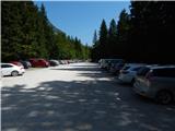
We drive to Mojstrana, then follow the signs for Vrata Valley. We continue along the toll road, which is closed to public traffic in winter, following it to the large parking lot located a few minutes before Aljažev dom v Vratih.
Route description:
From the parking lot, we continue along the gravel road closed to public traffic, passing Šlajmerjev dom and quickly reaching Aljažev dom v Vratih.
We bypass Aljažev dom on the right and continue straight towards Triglav, Sovatna, Luknja... (right Škrlatica, bivouac at Rušje...). We continue along the poorer gravel road, which leads us past the winter room to a marked junction at the famous peg (monument to fallen partisan climbers).
We continue straight again (left Tominškova pot), a gentle path leading us with beautiful views of Triglav and the Triglav North Face. After a few minutes of walking, we enter a beech forest, where the path to Sovatna branches right; we continue straight towards Luknja and Triglav - the path over Prag. A short ascent on the cart track follows, then the markers direct us left to the path that approaches the bed of Triglavska Bistrica. Here the path leads past the memorial to mountain victims, and shortly after we reach the next marked junction.
Straight ahead the path continues to Luknja, but we go left towards the path over Prag, where it first leads across the Triglavska Bistrica stream (slightly higher is the source of Bistrica).
On the other side of the stream, we quickly reach the first steep section, where the first pegs assist us; after a few minutes, the difficulty eases, but we continue steeply ascending, with increasingly beautiful views across the valley from the path.
This section is partially overgrown with bushes, higher up safety gear reappears, and soon we reach probably the most difficult part of the path over Prag, where with the help of brackets and cables we climb a nearly vertical 15-meter chimney. The path gradually becomes easier again, Tominškova pot joins from the left, and a few steps further we reach Begunjski studenec.
We continue steeply ascending; technically this section is not demanding, after about 15 minutes we reach the next junction, where the path to Dom Valentina Staniča pod Triglavom branches left; we go straight, following the signs for Triglav and Triglavski dom na Kredarici.
The path levels out somewhat, bypasses Kotel on the right, and leads to Triglavske pode, where orientation is somewhat difficult especially in fog. On the upper part of Triglavske pode, the path becomes steeper and more technically demanding, with safety gear on the difficult spots.
After climbing above the steep part, the path levels out again, and with increasingly beautiful views, in a few minutes we ascend to Triglavski dom na Kredarici.
We continue right towards Triglav (sharply left summit of Kredarica and Kot Valley, left Krma Valley and Pokljuka) and descend on a technically undemanding path to Ledeniški preval, from where we begin ascending towards the ridge of Mali Triglav. Here we follow the markers and the large marker visible from afar, near which the very demanding path to Triglav begins.
Initially we ascend a not very steep slope with some pegs and individual cables, but when we reach the ridge of Mali Triglav, we traverse upwards to the left, where cables were added to the pegs a few years ago to allow self-belaying with a via ferrata kit. Several steep and exposed ascents follow, where we must be careful not to slip; on the section with loose stones, we must also be cautious not to dislodge rocks as it can be deadly for hikers below. The path ahead is quite narrow, and with many visitors, congestion can occur due to difficult passing.
Higher up, the steepness eases, and from the left joins the path from Dom Planika pod Triglavom via Mali Triglav, which we reach shortly after.
From Mali Triglav, a slight descent follows along an occasionally less exposed ridge; when ascending again, the ridge narrows, and the path becomes precipitous on both sides. Several steep ascents follow, the path is mainly well protected with cables and individual pegs; on nice days, congestion due to passing is possible all the way to the summit. Below the summit, the path becomes less demanding but still precipitous. Just below the summit, a path to Staničevo zavetišče (emergency bivouac carved into the Triglav massif) branches slightly left; we follow the still cautious but last few meters less steep path to Aljažev stolp, located on the summit of Triglav, the highest peak of the Julian Alps and Slovenia.
Starting point - Aljažev dom 0:05, Aljažev dom - source of Bistrica 0:55, source of Bistrica - Begunjski studenec 2:45, Begunjski studenec - Kotel 0:15, Kotel - Triglavski dom na Kredarici 1:00, Triglavski dom na Kredarici - Ledeniški preval 0:05, Ledeniški preval - Mali Triglav 0:35, Mali Triglav - Triglav 0:35.

Along the route: Aljažev dom v Vratih (1001m), Spomenik padlim partizanom gornikom (1020m), V Plazičih (1040m), Izvir Bistrice (1160m), Begunjski studenec (2091m), Kotel (2166m), Triglavski podi (2400m),
Triglavski dom na Kredarici (2515m), Ledeniški preval (2484m),
Mali Triglav (2725m)
Photos:
 1
1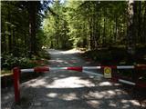 2
2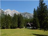 3
3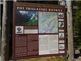 4
4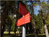 5
5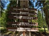 6
6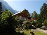 7
7 8
8 9
9 10
10 11
11 12
12 13
13 14
14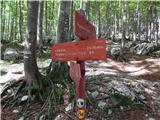 15
15 16
16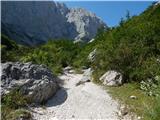 17
17 18
18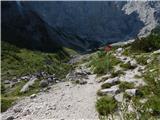 19
19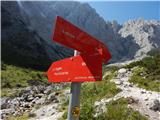 20
20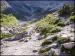 21
21 22
22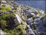 23
23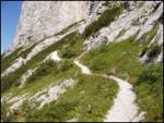 24
24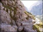 25
25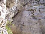 26
26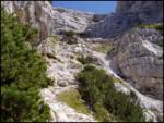 27
27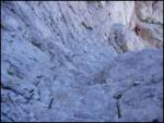 28
28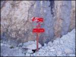 29
29 30
30 31
31 32
32 33
33 34
34 35
35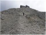 36
36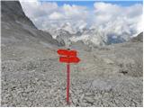 37
37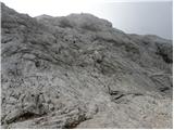 38
38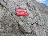 39
39 40
40 41
41 42
42 43
43 44
44 45
45 46
46 47
47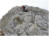 48
48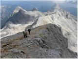 49
49 50
50 51
51 52
52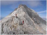 53
53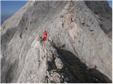 54
54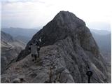 55
55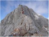 56
56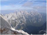 57
57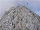 58
58 59
59 60
60 61
61 62
62 63
63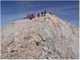 64
64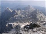 65
65 66
66
Discussion about the trip Aljažev dom v Vratih - Triglav (via Prag)
Show older messages
|
| Damijan13. 05. 2007 |
Easiest route from the north side from Vrata valley. A few interesting passages, a bit through a gully and on pegs. At the top, as expected, lots of people.
|
|
|
|
| Gost17. 07. 2007 |
I've been to Triglav many times, most often via Tominškova, but it seems to me that the path over Prag is no longer the "easiest". It's quite demanding and difficult. I don't recommend it to beginners without guides or experienced hikers. Miro
|
|
|
|
| Gost23. 07. 2007 |
mauka
|
|
|
|
| Gost23. 07. 2007 |
Beginners don't go to Triglav, what do you think it's really the nicest there. Far from it.
|
|
|
|
| Gost9. 08. 2007 |
It is the easiest route from the northern side from Vrata valley, true there are a couple of interesting passages that are very well protected. Time to Kredarica 4 hours then to the summit another 35 min (I'm a bit out of condition) for the fitter ones ... the time is shorter.
Best, Benč
|
|
|
|
| Gost19. 08. 2007 |
Benč, what are you messing around with up there??? Everyone goes according to their own strength,... what you're stating here is already the limit,... come on come on, yeah, everyone boosts their self-confidence in a different way, unfortunately,... 
|
|
|
|
| Gost21. 08. 2007 |
Zoltan, Isabelle and Zsolt UNGAR
16.08.2007
Thank God we made it in 18 hours ... Good luck to all... we'll return
|
|
|
|
| petka23. 08. 2007 |
Is there still such a crowd in September (midweek)?
|
|
|
|
| Gost23. 08. 2007 |
During the week it's already quite tolerable, but on the weekend at least at the beginning of September definitely not. That's when those 100 women go to the top.
|
|
|
|
| Gost31. 08. 2007 |
In August I went to Triglav for the first time, namely from Krma - up and down in one day.
Since I want to conquer the summit also from Vrata, I'm wondering if the ascent from Vrata to Kredarica is more demanding than from Kredarica to the top?
|
|
|
|
| Gost31. 08. 2007 |
I don't know if you're joking? The ascent from Vrata via Tominšek or over Prag is of course not comparable to the ascent from Kredarica to the top, as it's not a climbing route. If you made it up from Krma, you'll manage the path from Vrata to Kredarica without trouble.
|
|
|
|
| Gost6. 11. 2007 |
Hello everyone!
I'm interested where snow currently starts on this path, because I plan to go to the summit on Thursday.
Thanks, Janez
|
|
|
|
| simona321. 08. 2008 |
I'm interested in a comparison of the path over Prag and e.g. from Krma (or other so-called easier paths). Is the path over Prag really that demanding? Rok writes that it's a climbing path. What climbing grade?
Thanks and steady steps!
|
|
|
|
| viharnik21. 08. 2008 |
The paths you mentioned are not comparable. The path from Krma is the classic approach to Kredarica, also used as a winter approach. It is the easiest, so to speak for every mountaineer. Over Prag, however, is incomparably more demanding, a secured climbing path!, but easier than Tominšek's from Vrata. If you've already been on some ledges and pegs, then the ascent over Prag shouldn't be a problem - of course not in pre-thunderstorm weather! Best regards - Rok.
|
|
|
|
| sonce325. 08. 2008 |
Can someone tell me how much walking there is from Vrata
(Aljažev dom) to Dom V. Stanicha
(via Prag) and then from there to the top of Triglav?
Thanks and best regards!
|
|
|
|
| briner25. 08. 2008 |
Everything is written above. And it holds if two or three go. But if a group of 5 or 10 or more goes, the time stretches quite a bit. For example, 25 people aged 35 to 55 to Kredarica via Tominšek's in a good 8 HOURS.
|
|
|
|
| Brane7125. 08. 2008 |
sonce3 if you go to Triglav via Prag to Stanichev and then I assume via Rž, your path lengthens by at least 45 minutes if not more in my estimation.
|
|
|
|
| sonce326. 08. 2008 |
Thanks for the answers. Given that Kredarica is booked for overnight stay, Staničev dom remains. It would probably really be best via Rž, although we planned to return along the path and then towards Kredarica. Brane71, do you know anything about the path via Rž (regarding technical difficulty)?
Thanks and best regards!
|
|
|
|
| davorin26. 08. 2008 |
A little less than a month ago I walked that path in the opposite direction, i.e. from Kredarica via Rž to Staničeva koča. The path is extremely scenic and for average hikers not at all strenuous or dangerous. The pictures might help you (all taken on 30.7.2008.) of the path in the opposite direction. Best regards
|
|
|
|
| Brane7126. 08. 2008 |
There are some fixed cables on the path via Rž, but nothing demanding. Staničev dom has a very nice location and I would choose to sleep there even if there was enough space at Kredarica.
I wish you safe walking! Good luck!
|
|
|
|
| NEIC00826. 08. 2008 |
Does anyone know if there is any snow on Triglav??
|
|
|
|
| davorin26. 08. 2008 |
End of July there is no snow on the path from Planika via Mali Triglav and on the path from Planika to Kredarica.
|
|
|
|
| Bojan_A26. 08. 2008 |
3 days ago a little bit fell, but it is probably very south-facing and there is very little of it. Currently no problems with snow in principle.
|
|
|
|
| sonce327. 08. 2008 |
Davorin, thanks for the pictures. The path looks great, we'll go via Rž.
Brane71, regarding Kredarica you are quite right. I have already read on forums about the unfriendliness of the staff at Kredarica, and then I myself experienced total unfriendliness when I called about reservation.
I wish everyone a safe and successful path!
|
|
|
|
| ani427. 08. 2008 |
On Saturday I'm going to Triglav for the first time, fitness-wise I'm not best prepared, I have some shorter ascents behind me and I'm curious what the path from Krma to Triglav is like, whether it's difficult or strenuous for a mountaineer.
|
|
|
|
| ben27. 08. 2008 |
Not difficult, but strenuous.
Good luck
|
|
|
|
| davorin28. 08. 2008 |
sonce3
No problem. Nice to meet you.
|
|
|
|
| sonce38. 09. 2008 |
On Saturday 6.9.2008 first time on Triglav! The path via Prag is really super. For me personally not difficult at all, although I had some fear before. The weather wasn't quite right, but the visit to the top was divine anyway. We went down to Dolič, stayed overnight there, then via Luknja to Vrata. Also a very nice path, saw ibex and marmots. I recommend the described path to everyone who has at least a little joy in climbing.
P.S. What bothers me a lot is the "circus" on top of Triglav.  I too was very happy and proud to stand on the top of our Father. But it wouldn't occur to me to make such a fuss up there as some do. Some of us go to the mountains to enjoy the beauties, not to celebrate. I too was very happy and proud to stand on the top of our Father. But it wouldn't occur to me to make such a fuss up there as some do. Some of us go to the mountains to enjoy the beauties, not to celebrate.
I apologize in advance to all who disagree with me. But that's my opinion,
Best greetings to all and keep SAFE!
|
|
|
|
| Toni258. 09. 2008 |
Hello!
Tomorrow I'm going to Triglav via Tominšek route and I'm wondering if it's comparable in difficulty to the Slovenian route on Mangart and Hanza's on Mojstrovka?
If it's noticeably harder, I'll rather go via Prag.
Thanks for the answer
|
|
|
|
| triglavski8. 09. 2008 |
It is noticeably longer than both. Regarding the difficult sections, there is no real comparison, but if we add up difficulty and length, it is quite tough for someone going for the first time.
|
|
|
|
| Rok11. 09. 2008 |
The discussion on difficulty levels has been moved HERE, this page is intended for commenting on the path via Prag.
|
|
|
|
| Keco21. 09. 2008 |
Heading up on Wednesday if the weather is decent. To refresh last time up there 8.8.'88
|
|
|
|
| petruša26. 02. 2010 |
I'm wondering if from Vrata via Prag is a suitable path for children (10 and 11 years), last year we were already on Triglav from Zadnjica via Dolič. We did the path in one day up and down. We walked 13.5 hours, no problem. This year we'd like to go another path, interested in opinion. Kids have harnesses, helmets and self-belay. Additionally we have them tied to us. Thanks in advance
|
|
|
|
| IgorZlodej26. 02. 2010 |
The path via Prag is easier than Tominšek's, so suitable also for your children. Usually it's a descent path. Of course there are quite a few wire protections on this path too, so self-belay kit is appropriate.
|
|
|
|
| andrejjerina26. 02. 2010 |
Last year with my son (8 years) we did the ascent to Triglav from Krma valley, where there's something to see also for our little ones. Descent we did on the nicely and impeccably secured path via Prag. No technical difficulties on the path, there was a bit more scree, where the helmet on the head performed well. The only "issue" (if I can call it that) would be the belay over the jump where there are pegs. Just boldly. LP Andrej
|
|
|
|
| petruša27. 02. 2010 |
Best regards to both for replying to me, I think we'll try it here this summer. Did you sleep over with your sons or do it in one day.
|
|
|
|
| andrejjerina27. 02. 2010 |
The same day we headed to the summit, then returned to Planika where we slept. The next day we continued the path to Kredarica and via Rž (or under it) to Staničev dom and to Vrata. Personally I think it's better to do such a tour with kids in two days, but it certainly depends on several factors. Good luck and safe in the mountains! LP Andrej
|
|
|
|
| 00812. 05. 2010 |
Hi!
I'm interested in a comparison with the path via Plemenice. I've already read something about it, but I'm still interested in more opinions: comparison of the difficulty of the climbing section, views along the path, etc.
Thanks, Vid
|
|
|
|
| Bojan_A13. 05. 2010 |
Hi
The path via Prag is shorter, but in my personal opinion also more dangerous, because you're exposed to rockfall for a full 3 hours of walking (almost every year someone gets killed by a rock on this path). There are more climbing sections than via Plemenice, but they are easier. Except for that Medvedova skala, which is a very exposed section.
The views on both paths are such that you can't complain about them.
On the path via Prag, you also have Kredarica / Stanič's hut in between where you can replenish supplies, whereas via Plemenice there's nothing in between.
And to me: the path via Plemenice is much more appealing, because it seems safer and (slightly) more solitary to me.
Path descriptions:
Path via Plemenice: http://bojanambrozic.spaces.live.com/blog/cns!ACD975034630F7FE!9060.entry
Path via Prag: http://bojanambrozic.spaces.live.com/blog/cns!ACD975034630F7FE!7124.entry
Best regards, Bojan
|
|
|
|
| 00813. 05. 2010 |
Thanks Bojan,
Best regards V
|
|
|
|
| šodrovec13. 05. 2010 |
Still, it must be noted that the section of the path via Plemenice has always been considered the most difficult on the marked paths to Triglav. That hasn't changed. It is true that more experienced hikers go up there (down much less often) and therefore fewer rocks are dislodged. It's also true that only on this path can an ordinary hiker peek over the edge at the right spot and in a special way feel the greatness of the north face, then turn his head and spot the nicely rounded Zadnjica and (if he has a very good nose) catch the coastal scents.
|
|
|
|
| medo*13. 05. 2010 |
008, it must be said that the path via Plemenice is technically more demanding, as it is considered one of the most difficult secured paths to Triglav, where self-belaying is needed on the ascent from Luknja (via ferrata) and it's not for the vertiginous. The path via Prag is less demanding in this respect, of course caution is never superfluous. The views are beautiful everywhere in their own way
|
|
|
|
| golfdelta7429. 07. 2010 |
We went as an organized group of 33 hikers, start:09:50, arrival Kredarica hut 17:00. Of course we had some short and long stops (lunch, rest...) this was my first time on this path and I fully like it, because there is quite some climbing on pegs... it's not that steeply steep, no big ascents. Stones really fall easily, so it's worth wearing a helmet at least for your own safety. Otherwise, happy and safe on this path. GOOD LUCK
|
|
|
|
| tilnermor4. 08. 2010 |
To me this path doesn't seem difficult at all....even though I'm 15 years old. of course from Prag to Kredarica it drags like the devil himself...but when you get there, it's worth the effort!! =D
great view
|
|
|
|
| neph28. 08. 2010 |
For my first ascent of Triglav, we chose the path through Prag. We had previously informed ourselves quite a bit about the path (father and mother had already walked it), so we had no difficulties on the ascent. On this website (hribi.net), I got the impression that what would speed up my heart rate (from adrenaline) would be the described ~15m chimney, but in reality, the ascent from Kredarica to the summit seemed more "adrenaline-inducing" to me at some points, or more precisely the descent on this path (it seems to me that there should still be a warning that the path from Kredarica to the summit is no joke either; in fact, I think that anyone who can manage this part of the path can certainly also manage the path from Vrata to Kredarica through Prag, as far as the difficult sections are concerned). The ascent through the described almost vertical chimney is extremely well protected (wire rope + pegs, there are also many "steps" for the feet). On the first day, we climbed to the summit, where there was not too much crowding, and then to Staničev dom, where we spent the night. The next day, only a few pleasant hours of descent awaited us. Let me just mention that on Thursday it was an exceptionally nice day, practically cloudless, so the summit offered an exceptionally beautiful view of the surrounding mountains. On Friday morning, the sunny weather "still held," but soon the first clouds appeared in the sky, their quantity increasing from hour to hour. Overall, I can rate the tour as excellent.
|
|
|
|
| xAnja28. 08. 2010 |
Our group also headed to Triglav on Thursday - likewise from the Vrata valley through Prag. It was really a beautiful day, unlike the previous week when we had to turn back at Kredarica due to poor weather conditions (at that time we tackled the path from Krma). Precisely because of that, the satisfaction at the conquered summit was all the greater this time Next time, I would like to come to Triglav with touring skis and really enjoy skiing back down to the valley... Good luck on your paths!
|
|
|
|
| stolcar11. 08. 2011 |
In the eleventh picture, that jump looks VERY steep; is it really so problematic or not...? ????
|
|
|
|
| folpo11. 08. 2011 |
no, it just seems that way... but everything is very well secured, so you shouldn't have any problems
|
|
|
|
| Bojan_A11. 08. 2011 |
This one is easy; the passage over Medvedova skala on the 9th photo is harder.
|
|
|
|
| mdj31. 08. 2011 |
well let me say something small too, I set off to Triglav for the first time and chose this path because I wanted to get up and back in one day,... the path itself wasn't demanding for me, of course it totally depends on the individual,... back I went via Tominškova pot, also first time and there it's already a bit more demanding path,... good luck everyone
|
|
|
|
| el rocco4. 09. 2011 |
Yesterday's day on Triglav was a real gift . Otherwise, I wanted to say that this path over Prag is not so useless. Those without stamina can be worn out already halfway. But it's definitely a better choice than e.g. from Krma where we descended, because that one drags on like chicken guts.
|
|
|
|
| lokipoki16. 09. 2011 |
Hello!
I highly recommend the path over Prag compared to Tominškova; personally last weekend I didn't manage the ascent to Triglav via Tominškova because leg cramps were too severe and I only went to Staničeva koča and waited there for the others who made it... We descended over Prag and it is a wonderful descent compared to Tominškova just a little...
Over Prag I recommend, it is certainly less strenuous than Tominškova... The rest adrenaline takes care of...
In the mountains it is great...
|
|
|
|
| garmont18. 09. 2011 |
"Medvedova skala" is the most demanding part of the trail over Prag and is technically harder than any part of Tominškova pot. True, the trail is not so exposed, but due to the unpleasant scree underfoot it is objectively dangerous. Maybe no longer the most recommended for descent (my opinion).
Regards
|
|
|
|
| andrej7818. 09. 2011 |
Garmont, that is indeed your subjective opinion, but objectively every trail in the high mountains is dangerous. Over Prag is the best descent variant to Vrata, and you can turn it 12234409 degrees in any direction, it holds true as nailed!
|
|
|
|
| ben18. 09. 2011 |
For me the best and easiest descent variant to Vrata is along the valley behind Cmir, true it's unmarked and once you know it, in my opinion even faster than others, thanks to the excellent scree.
LP B
|
|
|
|
| gornik3322. 01. 2012 |
It's been a long time since I was on Triglav, but I'm interested if there's any snow and which path is best to choose....from Vrata side..through Prag or Tominškova?? Interested for May??
|
|
|
|
| ŠpRo2923. 01. 2012 |
I would choose (of course, if it's already snow-free and conditions are pleasant) up Tominškova and down through Prag
|
|
|
|
| Edi223. 01. 2012 |
In May there will most likely still be winter conditions in the high mountains, so I advise you to set off from Krma or postpone the trip to the summer months.
|
|
|
|
| gornik3328. 01. 2012 |
AHA..ISN'T THERE VERY LITTLE SNOW IN MAY??THERE'S TOO MUCH CROWD IN SUMMER,SO I'D RATHER GO IN MAY...
|
|
|
|
| urbancek28. 01. 2012 |
There can be much more snow in May than at this moment...
|
|
|
|
| IgorZlodej28. 01. 2012 |
There's little snow now in January, in May it could be several meters, I think you don't really know the conditions in the mountains.
|
|
|
|
| gornik3328. 01. 2012 |
YES IF IT WILL SNOW IN FEBRUARY AND MARCH THEN IT WILL, OTHERWISE IN APRIL I DON'T KNOW IF ANYTHING WILL FALL...
|
|
|
|
| IgorZlodej29. 01. 2012 |
Well, there's no need to shout, write like all normal forum users. Obviously you have no idea about the path via Prag and Tominškova. Until June there's always a lot of snow there, it's not all about snowfall, avalanches also do their part and there are many there. Anyway, as far as I'm concerned, you can go up even now.
|
|
|
|
| slamca29. 01. 2012 |
sounds obviously bad
|
|
|
|
| gornik337. 02. 2012 |
I heard from some mountaineering club that there was little snow there last year...beginning of May, so it was completely normal to walk...for this year they say it won't be bad either..because there will probably be less snow..even though these past few days winter showed up...unless it snows again in March...
|
|
|
|
| gornik337. 02. 2012 |
I don't know the current conditions, because I haven't been to Triglav for 4 years...but before that I was there 15 times without problems.
|
|
|
|
| mukl30. 07. 2012 |
what a stupid debate about snow in May, I mean, stupid question, every year is different, it can be no sign of snow, or it can dump a nice amount in mid-May...
|
|
|
|
| jprim30. 07. 2012 |
@mukl
... you're good, five whole months after the question was posted you reply from ...
LP!
|
|
|
|
| ljubitelj gora30. 07. 2012 |
No question that anyone asks is stupid, that's why this portal exists.
|
|
|
|
| dashwallace30. 07. 2012 |
I really don't understand ''people''... who comment on things thoughtlessly, humanly...
mountain lover
30.7.2012 No question that anyone asks is stupid, that's why this portal exists.
WELL SAID...
''THERE ARE NO STUPID QUESTIONS, THERE ARE STUPID ANSWERS''
Best regards and be people not politicians... Have a nice day
|
|
|
|
| dashwallace30. 07. 2012 |
On the Forum I miss the option to edit... already written messages.... Administrators
|
|
|
|
| IgorZlodej30. 07. 2012 |
Yes then you should go to the "forum" not to commenting on trips, look around a bit, the view is good.
|
|
|
|
| Rak30. 07. 2012 |
@dashwallace - it can be edited, I was in doubt a few days ago too. You write the comment, press send, when your comment appears there's a field on the right with boxes for ...., click on edit and change, then click "Send" again
|
|
|
|
| Domch6. 08. 2012 |
On Saturday did the premiere ascent to Triglav and back. Nice tour, weather not too hot just very humid in the lower part. Summit clear until 9am then clouds covered it. Path via Prag is steep and has some easy climbing sections, nothing special. From Kredarica up the path is very well secured, here and there a pulled peg missing, but with such masses of people understandable. The hardest part is definitely the descent from Little Triglav, where increased caution is needed. Descended via Stanič and back via Prag to Vrata. Nice tour and I'll return.
|
|
|
|
| kraljevic23. 06. 2013 |
Yesterday I ascended to Kredarica via Prag. The path is great, precisely three small snowfields where ice axe help is useful. The trail is slightly damaged in a few places due to avalanches, but it doesn't pose a major obstacle.
To Triglavski podi the path is dry, further on the narrow path nicely leads to Kredarica.
|
|
|
|
| mukl11. 07. 2013 |
Will there be any snow on April 28, 2014?
|
|
|
|
| pikica111. 07. 2013 |
Nah @mukl just bring your backpack so your ears freeze numb later 
|
|
|
|
| mukl11. 07. 2013 |
No, I wrote that question because about a year ago I was reprimanded (see posts from January 2012 onwards), because I said it's silly to ask on 22 January if there'll be any snow on this path in May, because it's not a motorway where you can predict after holidays and vacations when there'll be e.g. traffic jams etc.,
Here though, my dears, it's about the weather, no one knows how much snow it might dump in the mountains from January to May... OK, I'll conclude this topic
|
|
|
|
| tilko3220. 07. 2013 |
and does anyone know if it's already passable below Čez Prag without crampons and then onwards to Triglav
|
|
|
|
| otiv21. 07. 2013 |
@tilko32 you can find the conditions on paths in Forum-current conditions and questions about the state of the path you're heading to are also asked there.
|
|
|
|
| petruša21. 07. 2013 |
Hello, we did it yesterday, before Kredarica there are snow patches that can be crossed without any problem. With us were children 13 and 14 years old and they went through the snow without issues. Best regards
|
|
|
|
| tropine24. 07. 2013 |
Hello, has anyone gone these days to smiri luknjepa via plemenice, I'm interested in what the path is like (regarding snow) and also to the top of trilava, I plan to go Friday up Jože l.p.
|
|
|
|
| Sopke2. 08. 2013 |
Hello mountain lovers respect I'm interested if someone can tell me how suitable this path is for the first ascent to the roof of Slovenia or if it would be wiser to choose another one. Thanks
|
|
|
|
| ljubitelj gora2. 08. 2013 |
From Krma past Planika to Mali Triglav and to the summit, next time try from Vrata.
|
|
|
|
| stipi6922. 03. 2014 |
We did it with a friend three years ago (end of August) up and down in 12 hours, we were both on Triglav for the first time... it took 12 hours with several short breaks but a path not to be taken lightly, then visibly tired, would have liked to ride a cow for the last part back to Aljažev dom
My rating though, beautiful path!!!
|
|
|
|
| Cuco11. 07. 2014 |
Hi!
Could someone who was there recently or who plans to go to Triglav (not necessarily from this direction - Krma) please write how the snow conditions are.
Do you think it would be safe to reach the summit weekend 19-20.07? To Kredarica probably no problem or am I wrong?
Thanks a lot! nasmeh
Mitja
|
|
|
|
| ElBombinho20. 07. 2014 |
Hi everyone!
Please kindly provide an "update" on snow conditions on the Path over Prag and/or Tominšek's? Is the path safely passable?
Thanks and best regards!
|
|
|
|
| Ohrovt30. 08. 2014 |
Today I was on this route and I really recommend it to everyone—you're up very quickly and super views. It is really easy—if the stretch from Kredarica to the top of Triglav seems OK to you, this will be much easier.
But I noticed that a looot of inexperienced hikers go to the top. It was quite painful to watch those uncertain steps and fear. And also scolding families! If your 6,7,8 year olds are not experienced hikers then this route is not suitable for them. We waited for the descent behind two groups—four kids, who probably (not exaggerating—I was at the top for half an hour, and they had done just 200 m down) took 3 hours for the descent! Not to mention that they were very scared, it was visible they didn't know how to step,.. I really don't understand what's not clear to such parents. They'll go when they're ready... Well, they extended the route for the rest of us by at least almost an hour because such a jam formed.
But we also met a couple of kids of similar age for whom it was visible that walking on such terrain was no problem for them..
|
|
|
|
| mashyms16. 10. 2014 |
The path is really nice.. I recommend it
|
|
|
|
| ms_primoz17. 10. 2014 |
if this path is nice, then I don't know... I don't recommend it to anyone... just scree all the way... especially for descent I don't recommend it to anyone...
|
|
|
|
| redbull17. 10. 2014 |
idk what's wrong with the path over Prag, it's the only sensible descent path.
|
|
|
|
| Domch17. 10. 2014 |
The path over Prag is a solid path. You go up quickly, it has some minor climbing, helmet mandatory because there's really a lot of scree and rocks this year. For the descent, a great deal of caution is needed due to scree, you can easily slip over an edge or fall on that last part; definitely the path is easier in any case than descending via Tominškova or over Plemenice. Compared to descending via Frischaufova from Grintovca, this path is like a little highway.
|
|
|
|
| ms_primoz17. 10. 2014 |
nothing is missing, there's too much of everything
path 2 years ago or now - no comparison...so much more scree this year...or 2 years ago there was none at all...
|
|
|
|
| markohorvat25. 10. 2014 |
Hello. I'm interested in the conditions since the last snow. Is there a lot of snow and is winter gear needed? Thank you.
|
|
|
|
| polo1117. 07. 2015 |
On Saturday I would go from Vrata at least to Kredarica and I'm wondering if there's still any snow on this route.
|
|
|
|
| Smetar17. 07. 2015 |
A few snowfields, but they can be crossed without winter gear or largely avoided.
|
|
|
|
| 75'er11. 08. 2015 |
After many years I descended to Vrata via Prag. I don't know why, but I have the feeling that the descent on this path is not at all pleasant for unaccustomed hikers, let alone easier than Tominškova.
I'm talking about scree, a considerable number of pitons, which pose a significantly greater problem for the inexperienced than a few wire ropes on Tominškova.
|
|
|
|
| regggie8. 09. 2015 |
Is the path over Prag so poorly marked that yesterday hikers missed the path and strayed into the north face?
|
|
|
|
| Daaam8. 09. 2015 |
No. I don't know what caused them to stray. But the path over Prag is definitely one of the better marked and trodden paths we have..
|
|
|
|
| ljubitelj gora8. 09. 2015 |
...this trail has a branch-off to the Slovenska smer route...
|
|
|
|
| Zebdi8. 09. 2015 |
..marked?
|
|
|
|
| Gost8. 09. 2015 |
The branch-off to the Slovenska smer route is increasingly trodden and can mislead many people because of that. Decades ago, you needed a good nose to find the branch-off, nowadays everything is trodden at the branch-off point. In recent days, the weather wasn't the best either: fog, low clouds, lower temperatures, and some fresh snow. It might be sensible to consider putting up a signpost at the branch-off to guide hikers/mountaineers in the right direction-through Prag.
Life can really be beautiful, but only as long as you live it.
|
|
|
|
| pikica18. 09. 2015 |
Yeah right, soon we'll need a sign for every chamois path so no one turns there. If you set out for the mountain on a marked trail, stick to it. You can't wander along the marked trail for a while and then suddenly head off into the "unknown".
Visibility was good in the mountains yesterday, here and there some fog right on the summits, lower down clear. They pay too little attention to the path they're on, everything else is to blame but not them.
|
|
|
|
| milepetro8. 09. 2015 |
You know what. It happens. Even if the poor guy had survived, he probably would never miss this path again. We sometimes make mistakes on the simplest things, because when things are properly spiced up we're also more attentive, on edge....
|
|
|
|
| lino8. 09. 2015 |
What was the cause of such a tragic mistake here we probably will never find out. If this were a religious forum they would say: "Strange are the ways of the Lord.".
|
|
|
|
| Gost9. 09. 2015 |
I'll respond somehow like this....
In the mountains it's not enough to have nice weather, good equipment, knowledge and solid physical fitness. Very often luck is also needed for a safe ascent and descent.....
pikica1 - we weren't in a situation where we could discuss so nonchalantly
|
|
|
|
| JusAvgustin9. 09. 2015 |
They weren't the first and certainly not the last who went right towards the Wall at the trodden branch-off... But it's clear that if markers don't appear for some time and after a certain time you literally run into a peg driven in, something's not right... But we can be smart here as much as we want. The fact is that wall rescue was needed and the poor guy succumbed to his injuries. But I agree with pikica regarding the marking!
|
|
|
|
| lino9. 09. 2015 |
JusAvgustin, as a great expert on mountains and mountain trails, nicely gave concrete advice - even on marked trails you have to walk with open eyes and have a bit of luck.
|
|
|
|
| Saš19679. 09. 2015 |
It might not be bad to add a note in the description of this trail about where the tricky spot is (turn-off to Slovenska smer) and add a photo.
|
|
|
|
| jedriličar9. 09. 2015 |
At the junction to the wall (Slovenska, Deutsche ...) there is one large boulder, on it PRAG is written in large letters and an arrow to the left, so you can't miss the trail at that spot. But it's not marked enough, should we put something else? And if you look at the map, you'll see that the path to the wall isn't on the map...
|
|
|
|
| franca9. 09. 2015 |
Very fresh experience from last Saturday: a young Hungarian woman waited for me and my friend, who was in serious mountains for the first time, because she didn't know where to go next. The markings were visible, the path trodden, only there was also a small path to the left, which was quite a bit further from the turn-off to Slovenska. When they then walked ahead of me, both inexperienced, they were in doubt several more times. It seems to me that without knowing the terrain and inexperience, you simply don't know how to look for passages, and you don't notice the markings.
|
|
|
|
| Keko9. 09. 2015 |
Almost every day we hear on the radio that someone drove onto the highway in the opposite direction, even though everything is marked and full of additional signs and barriers. Nevertheless, there are some for whom that's not enough. There are cases where people blindly follow navigation and drive thousands of kilometers away from their goal or straight into an abyss and don't notice it or notice it too late. No matter how well the trail is marked, there will always be someone for whom it's not enough. Last year I went down through Prag and the path seemed nicely marked and followable to me.
|
|
|
|
| lijaneja9. 09. 2015 |
Something similar happened years ago on Jermanca. A nicely trodden and comfortable turn-off to the right was quite inviting and you were already on the pathless Repov kot. Goodbye, Kamniško sedlo.
|
|
|
|
| fafko10. 09. 2015 |
Maybe someone knows if there's any snow on the trail?
|
|
|
|
| Optimist00712. 09. 2015 |
Yesterday, 11. 9. 2015, descent from Kredarica via Prag to Aljažev dom - no snow!
|
|
|
|
| VincentGallo13. 04. 2016 |
what's the path over Prag like currently? are the pegs, cables, ladders on Uni skalci exposed or everything under snow? cheers
|
|
|
|
| redbull13. 04. 2016 |
Medvedova skalca is probably dry, but therefore surely everything else under snow. The sun doesn't shine there so snow on the path won't run out for long. It's passable, but with good path knowledge and head
good luck
|
|
|
|
| jedriličar17. 04. 2016 |
The road to Vrata is dry and passable to the parking lot at Aljaž, but still officially closed with signs. Winter trail open only the lower part. I advise against the ascent to Kredarica via Prag due to possibly wind-blown and dangerous snow (on Friday we met two who turned back at about 1,800 m and descended back to the valley).
|
|
|
|
| to68ne17. 07. 2016 |
Hello!
In the first week of September, my daughter and I plan to head to Triglav. We were on Triglav last year too (from Savica waterfall, Triglav Lakes, Dolič, Planika to Triglav. Back via Vodnikov dom to Pokljuka). My daughter would like to go up again, but not the same route, so please help. We would go from Vrata, via Prag (this path seems to me somehow the best and easiest regarding paths from Vrata, but my daughter is worried about the cables. Which path can I compare the cables to - Mangart??? I'm mainly asking because I read articles and opinions are divided. Some say the path isn't that dangerous after all, some say you need a guide.... Mountains are not new to us, but we would climb this route for the first time. Please some advice. Thank you
|
|
|
|
| valerija11217. 07. 2016 |
If you made it up from Planika, you'll surely manage via Prag too! Good luck.
|
|
|
|
| to68ne17. 07. 2016 |
Great. Thank you very much for the answer and encouragement
|
|
|
|
| to68ne19. 07. 2016 |
One more help please, namely, hike to Triglav from Vrata via Prag, do I need self-belay equipment. Helmet yes, full set? I'm asking because I look at pictures and rarely see anyone with this set. It's true that you rarely see it on Triglav either, more no than yes. I know it's certainly recommended for safety, but I'm wondering if it hinders you too much. Can you give me some advice please
|
|
|
|
| Branee19. 07. 2016 |
That's such an ungrateful question, it depends on how at home you are in the mountains, in principle if you don't use it from Kredarica to Mali Triglav you don't need it here either. Helmet definitely because some kick so that every step sends stones flying
|
|
|
|
| mirank19. 07. 2016 |
I completely agree with Branee, otherwise I don't know why you keep mentioning that path via Prag; it doesn't pose a problem at all, or if it does, better turn back. In my opinion, yes, difficulties start above Kredarica
|
|
|
|
| Rehi19. 07. 2016 |
Maybe it would be better if you tried the Slovenian path from Ravenska kočna to Kranjska koča na Ledinah. If there is no problem there I think there shouldn't be on the path via Prag either.
|
|
|
|
| valerija11219. 07. 2016 |
To68ne, repeating once again. If you made it up from Planinica, you'll do via Prag and Kredarica too! Enjoy, and report back your experiences.
|
|
|
|
| ljubitelj gora19. 07. 2016 |
@to68ne: Recommended equipment (summer): helmet, self-belay kit
|
|
|
|
| Gost20. 07. 2016 |
to68ne - the path via prag is quite nicely laid out, but caution is still needed (risk of falling rocks). On the path itself there are quite a few "prags" which we overcome with the help of cables and pegs. If your daughter worries about the cables, there's nothing wrong with that, as it shows respect to the mountain. Maybe equip yourself with a climbing harness anyway, as it's better to have it on than carry it in the backpack. If you think the self-belay kit is some kind of obstacle that slows you down, you can tie a prusik or sling to the harness for your daughter, make a clove hitch at the end, and she can clip in where she feels like it. When resting, taking photos or just admiring the surroundings, it might not be bad to clip onto the cable or peg then. Good luck.
|
|
|
|
| simon7920. 07. 2016 |
That's right en-goldy, safely and cautiously.
And I absolutely disagree with valerija112.
The path from Planika to Mali Triglav is not overly demanding, mainly on the harder sections it's scrambling on sloped terrain with the aid of wire ropes AND it's not very steep/exposed, which you couldn't say for the path from Kredarica to Mali Triglav. Locally you're almost vertically in the wall, instead of wire ropes mostly pegs, below you a couple hundred meters...I don't want to scare, it depends on the daughter's experience. Through Prag it's nicely routed, but easier uphill than downhill. Nice greetings and good luck!
|
|
|
|
| to68ne20. 07. 2016 |
I think I've got the answer. Many thanks to everyone for the help, and I'll let you know when we return from the path. Until then best regards and heartily to all mountain lovers.
|
|
|
|
| tojo9. 08. 2016 |
Yesterday I went up Tominšek (path is dry, not as difficult as they say, can be done without SVK no problem), then to Triglav, then down via Prag. I deeply regret the choice of descent.
1. Afternoon sun beats directly on the path, no tree to hide in shade.
2. Path less climbing than Tominšek but mostly over scree and very slippery, slight downward slope makes every step uncertain.
3. Path longer due to smaller slope than Tominšek, and after tremendous torments reaching valley, still long downward-sloping path jamming toes into boots along river to Aljažev dom (Tominšek doesn't have this, reaches valley almost at hut).
For one-day to Triglav from Vrata and back, definitely recommend up and down Tominšek. Especially down, upper part more climbing kinder to feet than toe-jamming, lower forest shade welcome, steps in forest ease descent, forest floor better than slippery rocks on Prag.
Wouldn't wish such torments my friend and I had yesterday. For down Prag, do two-day tour for fresher legs.
Regarding via ferrata set on Prag, I think not needed, only one rope, mostly pegs.
Best regards all! smile
|
|
|
|
| matzaj9. 08. 2016 |
Ha ha. Agree with point 2. Totally messed up path for descent.
But don't think Tominšek is much easier down, drags on too. Much more than uphill.
If at all - up via Plemenice and down Tominšek.
Paths like Prag (e.g. from Grintovec over roof) are really very unfriendly.
|
|
|
|
| IgorZlodej9. 08. 2016 |
@tojo, I think the problem wasn't the path, but the footwear 
|
|
|
|
| ZeK9. 08. 2016 |
tojo
the path over Prag is quite pleasant for descent in my opinion.
of course, in these parts, the valley behind Cmirom wins for descent.
complete peace and nature.
|
|
|
|
| redbull9. 08. 2016 |
I'd advise for Cmirom. There you might see your toes through your shoe if it was already a problem over Prag
|
|
|
|
| to68ne17. 08. 2016 |
The plan is a two-day trip, specifically up to Triglav via Prag, then to Dolič, overnight there. Next day to Prehodavci, 7J then to Planina pri Jezeru and Vogar. Transport picks us up in the valley.
|
|
|
|
| oger8. 09. 2016 |
Yesterday I went to Triglav via Prag. Despite no sun and strong wind from Kredarica to Triglav, it was wonderful. The path itself is great, some pegs and aids but no major problems. Recommended.
best regards
|
|
|
|
| to68ne11. 09. 2016 |
On Friday we set off on our circular tour and it was wonderful. Ideal weather, according to those we met, the morning wasn't great, but the afternoon was beautiful, without a single cloud, fantastic views. We also met the "100 women on Triglav", which was the only minor obstacle, as we had to wait quite a bit, but no problem, it was really nice, as was the next day from Dolič to Vogar. The only thing they advised us was choosing the Tominšek path instead of through Prag, at least for those who prefer cables.
Thanks for all the help and best regards
|
|
|
|
| Chaos12315. 06. 2018 |
Has anyone been over the Prag? How is the snow.. I have crampons anyway, just no ice axe... I wouldn't want to turn back halfway if it's still quite wintry. Regards
|
|
|
|
| tropine16. 06. 2018 |
There's still a couple of snow patches in the gullies from Prag onwards and it's snowy, seen from Gamsovec. Yesterday I talked to a couple who came over Prag and they had both. Good luck.
|
|
|
|
| Chaos12316. 06. 2018 |
Thanks for the reply, I've decided to go from Krma instead... better safe than sorry there it's possible normally without winter gear
|
|
|
|
| Chaos12316. 06. 2018 |
I could have gone even a little faster
|
|
|
|
| marsus19788. 08. 2018 |
Hello,
My colleague and I are heading to Triglav via this path. Based on your experiences, I'm interested if there will be crowds on this path at the end of August and whether you recommend ascending on a weekday or weekend. I lean more towards weekday ascent. We'll overnight at Aljažev dom and set off early morning - around 3 or 4. What's your opinion.
Best regards.
Marjan
|
|
|
|
| Lord Pes8. 08. 2018 |
Yesterday we descended from Stanic to Aljažev dom v Vratih (via Prag). I am an experienced hiker, my wife and 10-year-old son actually have no climbing experience, but they did excellently, the path really isn't too demanding, all exposed sections are well secured. And yesterday we were also on Triglav, chose Tuesday because supposedly no crowds, not many Slovenians indeed, but foreigners (including quite a few inexperienced) like leaves and grass, crowd to go mad, more than 2 hours we needed for descent to Kredarica, of which we surely waited 45 min in the wall for foreigners to squeeze up and down. Since Saturday we've been hiking and everywhere had "problems" with crowds, as there's an insane number of foreigners on our huts.
|
|
|
|
| Vitaja20. 08. 2018 |
On Wednesday, August 15th, we went along this path. First time for me, but I conquered it despite my fear of heights. The path is well secured, so I didn't use a via ferrata harness here, unlike on the path to Triglav We stayed overnight at Kredarica, and the next day at 7 a.m. to Triglav (we waited for the fog to lift a bit). Fortunately, there was no terrible crowd. We returned via Planika and then to Dolič, where we stayed overnight. Then in the morning to Luknja and Vrata. Beautiful return path, lots of gentians, from Luknja downhill it's scree, but it goes slowly. Very proud that I succeeded
|
|
|
|
| Engis20. 07. 2021 14:33:44 |
Hi, does anyone know what the conditions are like on the path? Ice, snow? I'm planning a hike to Triglav tomorrow. Thanks!
|
|
|
|
| jbs20. 07. 2021 18:17:31 |
There is snow on the Podih, but it's not problematic, elsewhere it's dry ground, no equipment needed.
|
|
|
|
| Engis20. 07. 2021 20:25:13 |
Thank you very much for the reply!
|
|
|
|
| Engis1. 09. 2021 12:20:06 |
Hello, does anyone know what the conditions on the path are like? Ice, snow? Hike planned for Friday. Thanks!
|
|
|
|
| Andrey Ts14. 06. 2022 18:06:45 |
Hi, does anyone know what the conditions on the path are like? Ice, snow? We're planning a hike to Triglav on Friday. Thanks!
|
|
|
|
| bongo15. 06. 2022 19:11:45 |
There are three snowfields over Prag. Two are short and completely unproblematic, one is a bit longer, but I think now so much snow has melted from below that there's no panic or it can probably be bypassed. A good week ago extra caution was needed there and possibly crampons or at least an ice axe, but on Saturday it was already completely OK. Almost all marked ascents/descents to Triglav from Vrata are snow-free.
|
|
|
|
| Engis21. 09. 2022 08:48:03 |
Hi, does anyone know what the current conditions on the path are like? I'm particularly interested in whether access to the summit is possible without winter gear (how is the snow from Kredarica to the top)? Thanks in advance!
|
|
|
|
| Engis26. 10. 2022 14:33:08 |
Hello, is it possible with crampons to the top, if anyone knows?
Thanks!!
|
|
|
|
| papi4329. 11. 2022 13:53:34 |
Hi. Since there are quite a few good experts here, I'm asking for your opinion. Is it possible and especially is it sensible to try the route Aljažev dom - Prag - Triglav - Planika - Dolič - Luknja - Aljažev dom ... in one day? I'm aiming for SPP in stages and studying potential stages. Of course not now, but clearly in summer or autumn. Could it be done in about 14 hours? A bit long? Thanks in advance for your opinion. Best regards
|
|
|
|
| jax29. 11. 2022 14:03:42 |
On the ascent from Dolič or the junction to the mulatiera back towards Luknja, you'll probably curse the whole world and surroundings, otherwise it's doable with good fitness.
|
|
|
|
| mirank29. 11. 2022 17:11:09 |
Jax is right, albeit from a distant? year 92 but the memory of that part of the path hasn't faded. Afternoon, mid-summer...
|
|
|
|
| pohodnik5529. 11. 2022 17:35:41 |
What papi43 is asking is completely doable with a bit better fitness. I did this route early August, starting the hike in Vratih at 5am: Vrata-Staničeva koča-Kredarica-Triglav-Morbegnia-Šmarjetna glava-Dolič-Luknja-Vrata. I was having a beer in Vratih at 4pm, so it's definitely possible, assuming it was summer, and there were nice stops along the way (Staničeva, Kredarica, Triglav, Šmarjetna glava, Dolič-beer, Luknja, Vrata-beer). Now there are winter conditions up there and the story is completely "different". Think about it when the conditions are favorable. Best regards from the mountains. LP Tone.
|
|
|
|
| jbs29. 11. 2022 20:56:21 |
If Triglav in one day is no problem, then this tour shouldn't be either. At the end you just have to push those 250m of ascent back to Luknja.
|
|
|
|
| papi4330. 11. 2022 10:14:26 |
Thanks to the predecessors for their opinions! We'll see in September how the form will be... Regards
|
|
|
|
| Sifra12. 08. 2023 10:37:05 |
Hi, how demanding is the path from Vrata through Prag? Which of these three (Tominskova, Plemenice and Prag) is the easiest? I know none is purely easy but still probably there is some difference. I hike a lot in the mountains. Thanks for your opinion!
|
|
|
|
| jprim12. 08. 2023 11:34:52 |
@sifra
The most difficult are Plemenice, then Tominškova, the easiest via Prag, but that's my opinion, although even via Prag it's not easy, there is one vertical wall on the path, but no problem.
Best regards!
|
|
|
|
| Sifra12. 08. 2023 19:54:59 |
|
|
|
|
| anka199923. 07. 2024 14:38:53 |
Good day, I'm curious about the path if I go via Stanicev dom - is there any snowfield from Stanica to Kredarica, is SVK needed? Thanks for the answer, I've searched a lot but can't find a description of the path from Stanica to Kredarica anywhere. Thanks and best regards
|
|
|
|
| Fapo23. 07. 2024 16:26:09 |
You can find the description and photos of the path from Staniča to Kredarica on the path Dolina Kot - Triglav
|
|
|
|
| sla23. 07. 2024 18:15:47 |
There are a couple of snowfields, but the path is normally passable and no special equipment is needed.
|
|
|
To post a comment you must log in:
If you do not yet have a username, you must first
register.