Avsa - Monte Mataiur/Matajur
Starting point: Avsa (860 m)
| Latitude/Longitude: | 46,20040°N 13,58870°E |
| |
Walking time: 2 h 30 min
Difficulty: easy marked way
Elevation gain: 782 m
Elevation difference along the route: 800 m
Map: Julijske Alpe - zahodni del 1:50.000
Recommended equipment (summer):
Recommended equipment (winter): ice axe, crampons
Views: 131.170
 | 5 people like this post |
Access to starting point:
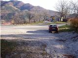
From the Kobarid–Tolmin road in the village of Idrsko, an asphalt road branches off to the right (to the left in the reverse direction) towards the village of Livek. We head onto this road and follow it to the village of Livek. Here we head right uphill in the direction of the village of Avsa. We continue driving to the beginning of the village of Avsa, where we notice the signs for Matajur on the right. We park on a suitable spot near a small intersection (parking in or at the intersection is not allowed).
Route description:
From the parking lot, we head right onto a poorer road, which soon turns into a cart track. The cart track then begins to ascend moderately, meanwhile bypassing a larger number of decaying cottages. The cart track then turns into a footpath, which steeply ascends for a short time, meanwhile crossing a grazing fence. The steepness then gradually eases and the path leads us along an increasingly less vegetated slope. The path then brings us to a forest road, where a road branches off right downhill to the shepherd hut on the Idrska planina mountain pasture.
We continue straight to the upper part of the mountain pasture along a path that offers increasingly beautiful views. A little further ahead, the road brings us to an intersection, where we continue straight and immediately thereafter notice the hut named Konjarska guta on the left side of the road. It is only a few steps of ascent to it.
From the hut on the mountain pasture, we continue towards Matajur. After a few dozen steps, the path brings us to signposts along the path. Here we leave the forest road and head right onto the footpath towards Matajur. Ahead, the path descends for a short time and after a few minutes brings us back to the forest road, where we continue right. Ahead we follow the wide, partly grass-covered road. After a few minutes' walk along the road, just after the water trough that we notice beside the road, a footpath branches off right uphill to Matajur. We head onto this path, which ascends a slightly vegetated slope. A little further on, the path climbs over interesting smooth rocky slabs and then crosses the forest road again. Ahead, the path continues to ascend moderately, meanwhile bypassing a small spring that dries up in dry periods. Just a little further, we reach a junction where the path from the village of Svino joins us.
We continue straight and the path, which ascends moderately, soon brings us to the next signposts, where we continue left uphill towards Matajur. Just a few steps further, we reach the border ridge between Slovenia and Italy. Here the path turns right and continues ascending along a wide gentle ridge. We follow this path, which takes us through increasingly beautiful views, to the summit of Matajur, which we can already see ahead.
Avsa - Idrska planina 1:10, Idrska planina - Matajur 1:20.

Photos:
 1
1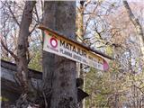 2
2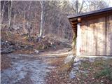 3
3 4
4 5
5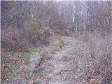 6
6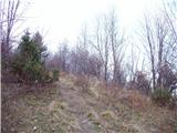 7
7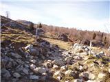 8
8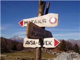 9
9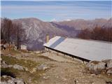 10
10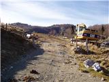 11
11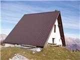 12
12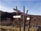 13
13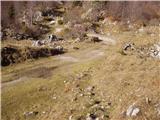 14
14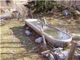 15
15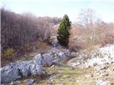 16
16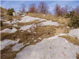 17
17 18
18 19
19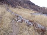 20
20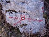 21
21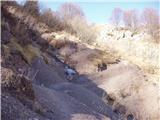 22
22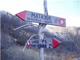 23
23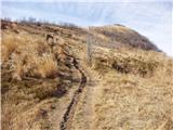 24
24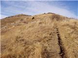 25
25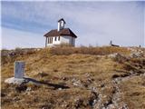 26
26 27
27
Discussion about the trip Avsa - Monte Mataiur/Matajur
Show older messages
|
| Gost12. 02. 2008 |
I hope I don't come off too silly ... But maybe someone knows if there's any snow up there? I don't know these parts very well ... Thanks!
|
|
|
|
| Gost13. 02. 2008 |
When I was up there they were just looking for escaped horses. But we ate plenty of blueberries, which are really tasty and big  and raspberries. We walked maybe a bit further, you know why and raspberries. We walked maybe a bit further, you know why . .
On the way back a heavy storm hit us and all paths turned into torrents in an instant. But the view from the top is very nice, the path is also suitable for a more beginner.
|
|
|
|
| Gost13. 02. 2008 |
nice view of the pre-alpine world of Nadiza where I also come from and on the Julian Alps
|
|
|
|
| Gost15. 02. 2008 |
Last week - on Friday - there was about half a meter of snow...
|
|
|
|
| Klin21. 03. 2008 |
There is also a nice and much shorter path to Matajur from the Italian side.
|
|
|
|
| triglavski22. 03. 2008 |
Exactly from the village Jerebi and not from the hut, to which one can drive.
|
|
|
|
| Sara318. 05. 2008 |
How difficult is the path? Is it suitable for a nearly 6 year old child. Thanks
|
|
|
|
| katjuša218. 05. 2008 |
yes of course it's suitable for a 6 year old child, if it's at least a bit of a hiker,...
You can walk on the trail or stone road from the times of our ancestors,...
my two were even younger, but we walked in August when we could still pick blueberries and raspberries
|
|
|
|
| Sara320. 05. 2008 |
Both the 6-year-old and the 8-year-old love hiking there. They already have a nice collection of stamps that they collect with enthusiasm.
|
|
|
|
| katjuša221. 05. 2008 |
Yes, our kids also collect stamps, we even have a notebook with hard covers for that purpose,... every hike is then confirmed with a stamp and an obligatory photo,..
we also pick up some small stone from the top as a souvenir, on which we write the peak and the altitude,...
on Matajur the stamp is in the chapel on the Italian side,..
|
|
|
|
| hribi16. 01. 2009 |
Klin, where is the starting point on the Italian side for this shorter path. I plan to go up in spring, so I'd like to know.
|
|
|
|
| Klin16. 01. 2009 |
In Idrsko, a village south of Kobarid, turn onto the road towards Livek. Here, do not continue right towards Matajur, but continue on the main road that takes you to Italy. On the Italian side, notice the road that leads to the starting point - direction village Matajur or Ital. Montemaggiore. If you drive by car to Koča Pellizo, it's less than 1 hour to the summit.
|
|
|
|
| noos23. 03. 2009 |
How is the path to Matajur, is it still snowy? Thanks for the reply
|
|
|
|
| greenhorn-ka24. 03. 2009 |
and what is the road like from the Italian side to the starting point - Koča Pellizo? From the hut you say it's less than an hour to the top, but how much from the village Jerebi mentioned in Triglavski? what is the road like to there? Thanks, thanks...
|
|
|
|
| noos1. 05. 2009 |
The stamp at the summit is very poorly visible. We were wondering if it's already so worn out or if someone damaged it with a stone.
|
|
|
|
| stoll2. 05. 2009 |
The stamp can also be obtained at the hut on Matajur - property of the Benečija mountaineering family, open every weekend of the year. From the top SW 5min. The road to Pelliza is asphalted and dry-bp. The path to the top is easy - in summer I have often seen Italian women on heels at the top.
|
|
|
|
| smidov david3. 05. 2009 |
With a little patience it can be stamped well even though it's quite poor. Otherwise I didn't find it in the chapel, as KATJUŠA2 wrote, I think it's not in the chapel.
|
|
|
|
| grahlck16. 01. 2010 |
How much snow is on this path?
|
|
|
|
| indiana18. 02. 2010 |
note: the intersection Avsa-Matajur-Matajur(old path) has no parking!! if you park there the tractor can't turn around there, and parking on (private) plots of locals along the road is not appropriate.
|
|
|
|
| m3. 08. 2010 |
Hello!
Does anyone know what that building with sheet metal roof that shines on the left (on the Italian side) is, when ascending from the direction of the village Avsa (or Livek) to Matajur? It looks like a mosque (dome).
|
|
|
|
| Ajda_Zitnik11. 12. 2011 |
I walked the path yesterday, 10.12.2011. The path was icy, and in places the ice had thawed forming mud, so in wet weather caution is definitely needed.
Regarding the stamp, they have a nice stamp at Dom na Matajuru, which is managed by Planinska družina Benečija, mostly expatriate Slovenes who are happy to see Slovenes visiting their hut.
|
|
|
|
| panda1023. 12. 2011 |
Hi! Has anyone been to Matajur in the last few days? What's the trail like or how much snow is there? Thanks for the reply and happy holidays and all the best in 2012. Good luck
|
|
|
|
| inspiron11. 02. 2012 |
11.2.2012:
-regarding parking: from the mentioned crossroads drive 300m further and there is (now newly?) arranged parking lot for at least 20 cars. Right across the road also starts a nice (much nicer than the mentioned one!) path - Stara Pot na Matajur.
-I went to check dom Matajure, but it is open only on Sundays (in summer months also on Saturdays after 14h) - so written on the door
-wind was surely 150km/h - impossible to stand still!
-currently crampons (at least hiking ones with 4 teeth or 'chains') are very welcome (at least for descent), on the path via Idrska planina probably mandatory.
|
|
|
|
| inspiron11. 02. 2012 |
Here's the track:
http://www.endomondo.com/workouts/iRcbZdTEyCQ
Up to Idrska planina via "Stara pot" (as already mentioned much nicer!) from Idrska planina then as described in this 'article'.
From Idrska planina onwards as described, down to dom na Matajure and then via the 'traverse' back to Idrska planina.
|
|
|
|
| Janiel7412. 03. 2012 |
Does anyone perhaps know? Is there any snow on the paths to Matajur? And on the top?
|
|
|
|
| Janiel7412. 03. 2012 |
And which path do you perhaps recommend?
|
|
|
|
| Kokta1. 04. 2012 |
Arranged parking 300m from the Avsa sign. The trail is dry all the way. Well marked. Stamp at the summit. Hut open on Sundays. I must mention that Matajur is one of the nicer SPP trails. I recommend visiting the hut on Matajur too. Very friendly caretaker who doesn't mind preparing something to eat. The view from the summit is divine. Overall an excellent choice for a mountain trip. Highly recommended.
|
|
|
|
| francimedved1. 04. 2012 |
If you decide for Matajur in the 7th month, the meadows there are one big flower field.
|
|
|
|
| Janiel744. 05. 2012 |
Went on this path yesterday. It's really nice. To the top, where the sign for Matajur is right up, down the old path. At the top completely alone
|
|
|
|
| malena20. 11. 2012 |
On Saturday 17.11.2012 from Avsa parking lot on the "old" path to Matajur. Super. And view from Mrzli vrh. Fantasy. Also quite a few hikers.
|
|
|
|
| Nogometni fanatik31. 01. 2013 |
Was up there on Sunday, 27.01. this month. Slovenian side, start a bit above Avsa. Path nicely tracked, no trudging through deep snow. Wonderful view from the top, on return went a bit off path; whoever opts for ski touring descent from top won't regret, plenty of snow even on road, descent would last over half hour for sure, relaxed pace of course...
|
|
|
|
| MKM26. 04. 2013 |
Hello!
Has anyone been to Matajur in the last few days and can report what the path is like or how much snow there is?
Thanks!
|
|
|
|
| mmcajna5. 03. 2014 |
On Saturday 8.3. I'd like to go from Avsa to Matajur. Does anyone know what the conditions are? Are crampons, snowshoes needed, how much snow? Thanks for the reply. Majda
|
|
|
|
| ciklama27. 12. 2016 |
Parking as described and shown in the first picture is no longer allowed. The parking lot is arranged 300 m further and from there the path also starts.
|
|
|
|
| mirank28. 12. 2016 |
Ciklama, that's how it has been for years already. And even nicer is the path there called "old path" from that parking (more on the sunny side and less through the forest).
|
|
|
|
| betka7. 01. 2017 |
Has anyone been up there recently, is there any snow?
|
|
|
|
| stzu516. 04. 2017 |
How is it now on Matajur, any snow remnants from winter left, is the path dry?
|
|
|
|
| funnyboy6. 04. 2017 |
Last weekend there was still some snow visible, probably even now patches here and there.
|
|
|
|
| lucylucy12. 08. 2017 |
The path is easy and suitable also for younger families. Markings for the old path are well visible, for the newer sections it would be good if some regular Matajur visitor described and marked them as the original record is somewhat outdated.
Good luck.
|
|
|
|
| JPogacar1. 09. 2017 |
Parking space is in the village AVSA 300m from the last houses.
|
|
|
|
| slamca24. 03. 2018 |
I sincerely thank the finder of the phone. Thank you, Boris.
|
|
|
|
| BostjanL21. 02. 2019 |
Has anyone been to Matajur or Kolovrat in these days? Is there still any snow? I'm thinking of an ascent by MTB bike and descent to the Italian side...
|
|
|
|
| ksena23. 02. 2019 |
From Avsa towards Matajur there are 3 km of dry road, then still quite a bit of snow. From the top to the Italian side it's snowy with dry patches, the road towards Matajur village is still snowy about 1 km from koča Pelizzo, further dry.
Lp
|
|
|
|
| J.P.7. 08. 2019 |
Very nice tour. If you don't have the whole day and want a shorter but still interesting tour, go for it. Views are great. Best regards
|
|
|
|
| ločanka7. 08. 2019 |
The winter one is surely nicer.
|
|
|
|
| bo_zl21. 06. 2021 21:32:19 |
Was up there yesterday on this trail. The beginning of the description needs correction:
Continue driving to the beginning of the village Avsa and continue driving another 300 meters to the marked and arranged parking lot on the left side. On the other side of the parking lot, a footpath branches off to the right into the forest. After a few tens of meters it turns onto a cart track.
After that the description above is completely correct.
|
|
|
|
| ovi13. 09. 2023 14:42:49 |
I agree with the predecessor; one of the few free well-maintained parking lots (starting point) with WC; the path is freshly additionally marked - great panoramic summit, of which there are few (under 1700m); -up 3 h (with breaks). down 2.30 (admiring views in between); Bravo, PD Kobarid!
Note - if going with a dog - take extra water for the furry one too!
|
|
|
|
| mirank14. 09. 2023 11:37:35 |
Don't praise too much and too soon. I saw the same symptoms under Krn; first dixi, then they buried a couple of bollards as parking markers. In a year or two, a barrier follows  , because they say they arranged it, but don't say they wasted European money on unnecessary things. , because they say they arranged it, but don't say they wasted European money on unnecessary things.
I'm really curious who the dixi serves - except justifying costs and consequently introducing profiteering. and consequently introducing profiteering.
|
|
|
|
| Tbs9. 05. 2024 18:10:13 |
Has anyone been up there? What are the conditions like?
|
|
|
|
| mirank9. 05. 2024 18:23:25 |
A bit muddy on Sunday, here and there some little flower, oh and some still usable dandelion can be found on the pasture
|
|
|
|
| Barentoter3. 06. 2024 12:17:42 |
I don't know the reasons why they made a "new" path? The old one is much nicer, better trodden and right from the arranged parking lot it climbs into the forest. On the way we can easily conquer the scenic Mrzli vrh (10 minutes off the path). Nice tour anyway. Hut open on weekends, at planina Idrsko you can get cheese, curd …
|
|
|
|
| mirank4. 06. 2024 17:37:59 |
What new path are you writing about? The path described here I last hiked more than ten years ago. Even before, on the now used path from the parking lot, the sign said: old path Matajur 2.5h on foot Crossing Srednjega and Mrzlega vrh is anyway a staple to spice up the path a bit. For the return, I usually use the path via the hut of the Benečije mountaineering society crossing the southern-Italian slopes past the hunting hut. I don't even know exactly where we cross the border there. Crossing Srednjega and Mrzlega vrh is anyway a staple to spice up the path a bit. For the return, I usually use the path via the hut of the Benečije mountaineering society crossing the southern-Italian slopes past the hunting hut. I don't even know exactly where we cross the border there.
|
|
|
|
| turbo4. 06. 2024 18:03:03 |
Probably the "new" one is the one at the beginning of the village, macadam, sharp right back up The "old" one is at the end of the village, on the slope, where there is a nice parking lot with panoramic panels, and it takes you directly to Mrzlega. Well, right below
|
|
|
|
| Rožcagre9. 08. 2025 14:05:24 |
A few days ago I was up there. The trail is very poorly marked, the blazes have faded, too far apart. Special care is needed in the upper section of the trail, which runs through pastures. The cows have trampled several paths there, so you can easily stray. The trail is heavily overgrown in places. I believe locals know where it is, but for the rest of us there were quite a few puzzles finding the right direction. Otherwise, the views are wonderful.
|
|
|
|
| jprim9. 08. 2025 19:32:26 |
@rožcagre
Oh, it's been like that for years already. Let alone in winter.
Best regards.
|
|
|
|
| mirank9. 08. 2025 22:08:17 |
I go up there at least three times a year - at least once in the snow and I wouldn't write about the markings because I don't even look at them and there probably aren't many of them anyway. I can't imagine there being any problems following the path on this trail, as the path is quite visible. And about any overgrowth, better not to write about it because there is none anywhere! unless you've completely lost your way. The path is visibly trodden and it is like that even in winter snow because there is quite a bit of traffic.
|
|
|
To post a comment you must log in:
If you do not yet have a username, you must first
register.