Baita Rododendro - Monte Lastroni (Sentiero 138)
Starting point: Baita Rododendro (1460 m)
| Latitude/Longitude: | 46,59300°N 12,72100°E |
| |
Route name: Sentiero 138
Walking time: 3 h
Difficulty: partly demanding marked way
Elevation gain: 989 m
Elevation difference along the route: 990 m
Map: Tabacco 01, 1:25.000
Recommended equipment (summer):
Recommended equipment (winter): helmet, ice axe, crampons
Views: 4.550
 | 4 people like this post |
Access to starting point:
After the exit from the highway Trbiž - Videm at the settlement Carnia (Tolmezzo) we follow the main road past Tolmezzo towards Villa Santini. In the center of the settlement at the roundabout, we leave the main road and go straight following the signs Raveo, Rigolato. We follow this road through Forni Avoltri all the way to the settlement Cima Sapadda, where immediately behind the church we continue right on a narrow and steep road in the direction of the source of the river Piave, Sorgenti del Piave. A little higher on the plain Pian delle Bombarde we park on one of the parking lots near the inn Baita Rododendro.
Route description:
From the parking lot, we go past the inn Baita Rododendro and through a bridge over the river Piave we step on the former military mule track Pian delle Bombarde - Laghi d'Olbe. At first a very steep path takes us above the gorge of the stream Rio della Miniera, where a view starts opening up on the southern slopes of the mountain M. Lastroni. The path flattens a little and goes towards the west. A little further, we get to a crossroad, left goes the path towards the mountain hut Rifugio 2000, and we go straight towards the lakes Olbe. The path then leads by the stream over the mountain pasture Olbe to the memorial chapel, where there is a juncture of several paths; to here it is possible to come also on a ski track or with a cable car from the valley Sappada.
From the chapel we descend towards the north towards the nearby lake and past it ahead to the next crossroad. Straight ahead leads the path on the saddle Passo del Mulo, and our path turns to the right towards the northeast. We again start ascending on a path that is quite rough for a short time, a little higher we cross a shorter scree below one of the rare rocky slopes and in a few hairpin turns we get to the ridge. There we run into the first bigger remains of shelters-observatories of the Italian army from the First World War, which then accompany us all the way to the upper part of the mountain M. Lastroni. The path becomes slightly exposed, on a smaller notch before the very peak, where it avoids the ridge a little, for a moment also more demanding. After a few turns the path quickly brings us on the upper ridge, on which we soon get also on the very peak.

Along the route: planina Olbe (2090m), jezero Olbe (2150m)
Photos:
 1
1 2
2 3
3 4
4 5
5 6
6 7
7 8
8 9
9 10
10 11
11 12
12 13
13 14
14 15
15 16
16 17
17 18
18 19
19 20
20 21
21 22
22 23
23 24
24 25
25 26
26 27
27 28
28 29
29 30
30 31
31 32
32 33
33 34
34 35
35 36
36 37
37 38
38 39
39 40
40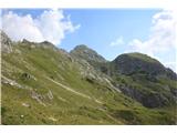 41
41
Discussion about the trip Baita Rododendro - Monte Lastroni (Sentiero 138)
|
| mirank14. 02. 2021 |
On the return, it is best along the ridge back to the Passo del Mulo pass and from there north to the Piave spring valley. If you also climb Monte Franzo along the way, it makes for a substantial and very interesting full loop tour
|
|
|
|
| Robie11. 08. 2024 14:05:25 |
Beautiful, easy trail with superb views. However, the recent rain has left quite some damage on the trail itself but normally passable. Along the trail also many water sources and even more marmots. If anyone else sets off with AD for this road, driving ban for AD applies, so must park in the village which means approx. 4 km longer one way - for return recommend along the river - trail marked as Sentiera naturistica.
|
|
|
To post a comment you must log in:
If you do not yet have a username, you must first
register.