Belopeška jezera - Mala Ponca / Ponza Piccola
Starting point: Belopeška jezera (929 m)
| Latitude/Longitude: | 46,47330°N 13,67130°E |
| |
Walking time: 2 h 45 min
Difficulty: difficult marked way
Elevation gain: 996 m
Elevation difference along the route: 996 m
Map: Julijske Alpe - zahodni del 1:50.000
Recommended equipment (summer): helmet
Recommended equipment (winter): helmet, ice axe, crampons
Views: 53.846
 | 4 people like this post |
Access to starting point:
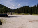
From Kranjska Gora over the border crossing Rateče we drive towards Trbiž / Tarvisio. Soon after the border crossing, the road in the direction of the Belopeška lakes / Laghi di Fusine branches off to the left, which we then follow in a moderate ascent to a large parking lot at the Upper Mangart (Belopeško) lake.
Route description:
From the parking lot, we continue on the left side of the inn in the direction of the mountain hut Zacchi. The path at first runs on the forest road, which we leave after a few minutes, because the blazes direct us to the left on a wide cart track. The cart track on which we walk changes a little higher into an ascending footpath. The relatively wide and well-marked path then in a moderate ascent through the forest in about an hour of walking from the starting point brings us to the mountain hut Zacchi (to here also possible on the forest road).
From the mountain hut, we continue on the left path, which already after a few steps of ascent goes into the forest. The path ahead at first in a gentle, then in a moderate ascent crosses the slopes towards the north, meanwhile crossing a larger number of gullies. Some gullies we cross with the help of small bridges, others on a well-maintained path. The forest path higher brings us to a vantage point, from which a view opens up on the Belopeška lakes and the surrounding hills. The path then goes again into the forest and after a few additional minutes of easy walking brings us to a poorly marked path junction, where a short path to the shelter branches off to the right (1 minute).
Just a few steps ahead, the marked path from the lower Belopeško lake joins us from the left side. We continue straight on the path, which after a few tens of steps brings us to a torrent stream along which pleasant spring water flows. The path ahead crosses the mentioned torrent and then with the help of a small bridge returns to the right side (left bank). A shorter somewhat steeper ascent follows on a wide stepped path, which leads us through larch forest. The path then turns somewhat to the left and higher brings us to a distinct gully, which descends almost from the top of Mala Ponca. The marked path here turns right and after further ascent gets completely close to the border ridge. Just a few meters before the Škrbina, the partly unmarked path turns left and crosses the slopes of the border ridge, on which we notice numerous towers. The path ahead in a slight descent crosses a slightly exposed gully, behind which we turn right and then ascend along the increasingly steep gully. After a short ascent, the path brings us to the top of the gully between two towers of Mala Ponca. A mark on the rock directs us left onto a steep path, which ascends steeply upwards through the dwarf pines. The steep and slightly exposed path then in 5 minutes of further walking brings us to the summit of Mala Ponca.
Starting point - mountain hut Zacchi 1:15, mountain hut Zacchi - shelter below Ponca 45 minutes, shelter below Ponca - Mala Ponca 45 minutes.

Photos:
 1
1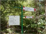 2
2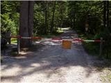 3
3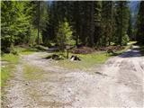 4
4 5
5 6
6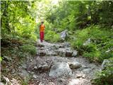 7
7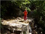 8
8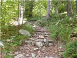 9
9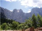 10
10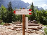 11
11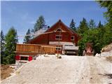 12
12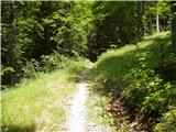 13
13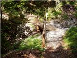 14
14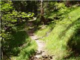 15
15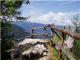 16
16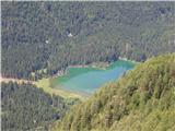 17
17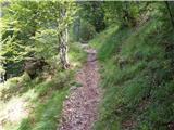 18
18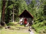 19
19 20
20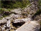 21
21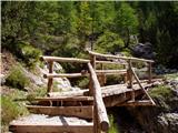 22
22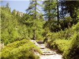 23
23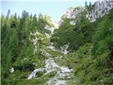 24
24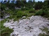 25
25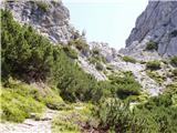 26
26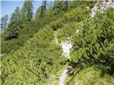 27
27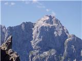 28
28 29
29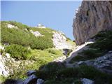 30
30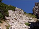 31
31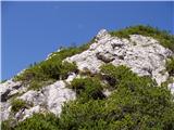 32
32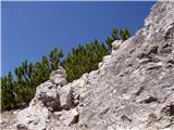 33
33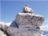 34
34
Discussion about the trip Belopeška jezera - Mala Ponca / Ponza Piccola
|
| žl1. 08. 2008 |
Up to Koča Zacchi quite noisy, because trucks are hauling huge rocks. When the hut is completed, it will all be nice, although personally I liked the old one a lot too. I prefer the crossing from the Planika side. From here I've gone only once, but the Planika side tour is very close to my heart.
|
|
|
|
| branči14. 08. 2009 |
13.8.09 to Belopeška jezera. Continued the path towards koča Zacchi and soon reached it. From there we went towards bivak Ponca, rested a bit and headed to the top of Mala Ponca. In the last part of the path a lot of care is needed, as the path is full of scree that hinders uphill walking, even more downhill. Among low dwarf pines in the final ascent need to look for the path which is poorly traceable, meaning this peak is not overly visited. That day too from bivak onwards we met no one, so we enjoyed the nice day and full peace. At koča Zacchi there were lots of people, which shows it's an interesting excursion point. Nives and Branči
|
|
|
|
| Kriška11. 10. 2009 |
Today Mala Ponca welcomed some visitors, but there was no particular crowd on the path, as most hikers stopped at koča Zacchi.
The association that takes care of the maintenance and marking of the marked path from the upper Belopeško jezero to Vratice (or a few meters below them) deserves all praise!
|
|
|
|
| al130. 10. 2009 |
Yesterday my colleague and I were at Mala Ponca from the lower Belopeško jezero. The path winds nicely through the forest and then among larches. It is also more scenic and incomparably more beautiful than the path past koča Zacchi. Recommended!
|
|
|
|
| veoniq30. 10. 2009 |
What are the conditions like - is the path dry?
|
|
|
|
| veoniq30. 10. 2009 |
What are the conditions like - is the path dry?http://www.hribi.net/slike/zmeden.gif
|
|
|
|
| pika31. 10. 2009 |
From the lakes the path is completely dry and nicely passable.
|
|
|
|
| dogna29. 07. 2010 |
Yesterday my husband and I were at the summit. We made a circular route. Start at the lower lake, then to the summit and past Zacchi hut back. Wonderful tour. Visibility was excellent, Mangart full of people, we were alone and only met some people on the return from the summit. Under the gate you need to be careful to turn left. I suggest PD marks the path from Planica too and together with Italians arranges a circular path.
|
|
|
|
| grega_p31. 07. 2010 |
Before Vratci several paths branch left, all lead to gully under Ponca, some more welcoming, others less. Put cairn at junction of the one described above. Recent rain washed gully well, careful with scree!
If overnighting in bivouac (shelter - pic 19), forget comfort: just two springs, no mattresses, one old blanket. Morning nicer though :-)
|
|
|
|
| hosti15. 10. 2010 |
Even though we're three hours drive away, it was worth it today, as the Julijci offered unique views. Very nice path to Mala Ponca past koča Zacchi, among golden yellow larches, in the sun, no wind, and at the top plenty of space to enjoy the views faaaaaar around. Too bad the day is short and you have to return quickly. This is probably our last high mountain tour this year, as snow is forecast for next week. Lp
|
|
|
|
| falcon1. 01. 2011 |
Beautiful hike.
|
|
|
|
| VanSims2. 10. 2011 |
The ascent isn't that demanding, but the descent to below Vratc, where normal markings resume, is quite unpleasant. Partly due to scree and slipperiness, partly because those orange dots are painted in a way that they are only followable upwards.
|
|
|
|
| slavko11. 07. 2012 |
Yes, interesting path, not even demanding, but you need to pay attention to the markings towards the end. The Italian ones lead you to a gate where there's a great view of Rateče and surroundings. Already before, turn left, some strange orange dots serve as markings and the steep path leads (10-15 min) to Mala Ponca.
|
|
|
|
| puma20. 08. 2012 |
The gully under Ponca looks a bit different today than in the picture here, with quite a bit of loose material, also the markings - those orange dots  through the gully have mostly been washed away. Likewise, the path to Vratice from the Mala Ponca-Vratice junction onwards is mostly destroyed. Otherwise, up to here the path is completely easy, further on more difficult, through the gully even engaging four-wheel drive , for descent locally unpleasant due to fine sand and gravel. through the gully have mostly been washed away. Likewise, the path to Vratice from the Mala Ponca-Vratice junction onwards is mostly destroyed. Otherwise, up to here the path is completely easy, further on more difficult, through the gully even engaging four-wheel drive , for descent locally unpleasant due to fine sand and gravel.
|
|
|
|
| Enka18. 08. 2013 |
Has anyone gone to Mala Ponca these days? How is the trail, still quite destroyed?
|
|
|
|
| istrumel21. 08. 2015 |
I'm interested if anyone has done the path to Velika Ponca and then continued to Mala. Nowhere can I find a description of the path and the time needed for it.
|
|
|
|
| istrumel23. 08. 2015 |
Yesterday I was up there, the path is normally passable no sign of anything collapsed.
|
|
|
|
| Ana00727. 10. 2015 |
I want to hike this path so wondering what makes paths from Belopeška jezera so particularly demanding? Not exactly an alpinist... Thanks
|
|
|
|
| bagi27. 10. 2015 |
@Ana007... If passing Koča Zacchi you'll go on very pleasant path marked 512. Higher there's another small hut and at junction below take right path 512a. Also very nice to saddle just below summit. Don't go to saddle but turn left to path into scree. Soon to "difficult" clogged gully no special issue dry. Above gully bit of rock and that's it Link for better impression ... http://jelenkamenmajdag.blogspot.si/2015/06/mala-ponca.html
|
|
|
|
| Clovek118. 12. 2015 |
Hi! I'm interested if there's any snow on Mala Ponca and if the path is trodden in that case? Thanks
|
|
|
|
| Enka8. 06. 2018 |
Has anyone walked the path from Lower Lake? Is that secured section OK? Some time ago the path there was closed, that's why I'm asking.
|
|
|
|
| VanSims9. 06. 2018 |
Last year it was open and nicely passable.
|
|
|
|
| Stoick11. 10. 2023 14:06:12 |
I was yesterday at Ponza Grande, the path is open again, new cables.
But I noticed that the path to Mala Ponca is officially closed, there are signs both down by the road and at the Zacchi hut.
Who knows what's happening?
As far as I know, the path is relatively easy, occasionally you see a cyclist too
|
|
|
|
| BorStenar13. 09. 2024 18:18:28 |
About a month ago I was up there, the path is open again.
|
|
|
|
| 2061alessio15. 09. 2024 19:06:53 |
The signs were put up by FJK owners for path 512 that part with the little bridge and ropes, now they are doing something on the variant, chainsaws were buzzing before the first snow fell, the signs are not intended for Mala Ponca or Vratnica.
|
|
|
|
| nekdo_nekje6. 06. 2025 23:27:21 |
Went up about a week ago, the path is nice, road toll is 5€. The last 15 minutes of walking are unpleasant especially downhill and require some caution. Towards the top there is also a very nice stream.
|
|
|
To post a comment you must log in:
If you do not yet have a username, you must first
register.