Belopeška jezera - Rifugio Zacchi
Starting point: Belopeška jezera (929 m)
| Latitude/Longitude: | 46,47330°N 13,67130°E |
| |
Walking time: 1 h 15 min
Difficulty: easy marked way
Elevation gain: 451 m
Elevation difference along the route: 451 m
Map: Julijske Alpe - zahodni del 1:50.000
Recommended equipment (summer):
Recommended equipment (winter):
Views: 130.420
 | 2 people like this post |
Access to starting point:
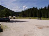
From Kranjska Gora over the border crossing Rateče we drive towards Trbiž / Tarvisio. Soon after the border crossing, the road in the direction of the Belopeška lakes / Laghi di Fusine branches off to the left, which we then follow in a moderate ascent to a large parking lot at the Upper Mangart (Belopeško) Lake.
Route description:
From the parking lot, we continue on the left side of the inn in the direction of the mountain hut Zacchi. The path at first runs on the forest road, which we leave after a few minutes, because the blazes point us to the left on a wide cart track. The cart track on which we walk changes a little higher into an ascending footpath. The relatively wide and well-marked path then brings us in a moderate ascent through the forest in a good hour of walking from the starting point to the mountain hut Zacchi (also possible to here on the forest road).
Photos:
 1
1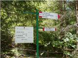 2
2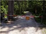 3
3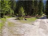 4
4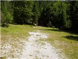 5
5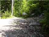 6
6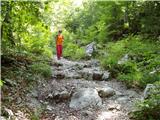 7
7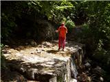 8
8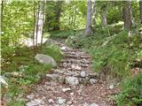 9
9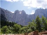 10
10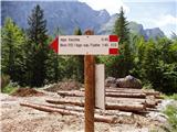 11
11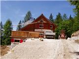 12
12
Discussion about the trip Belopeška jezera - Rifugio Zacchi
|
| laško28. 07. 2009 |
this is a very good trail. worth it.
|
|
|
|
| skalar504. 08. 2010 |
Nice idea for a family variant - even with small children. The renovated hut with a beautiful view of the Mangart massif also offers good food.
|
|
|
|
| 03183338530. 03. 2011 |
It's downright shameful that there isn't a single sign in Slovenian even though this is land that was brutally stolen from us. Just because it's stolen doesn't mean we don't know who the owner is even though Italians would very much like to forget about it as soon as possible...
|
|
|
|
| 2061alessio30. 03. 2011 |
or what would Italians say about all those now mountain paths and huts because they built them back then during the war when the border ran at sedlo Luknja and surroundings where now is Slovenia?? or shall we put up signs in both places "land abusively occupied?" please.... the world and life go on.
|
|
|
|
| IgorZlodej31. 03. 2011 |
Indeed, as Alessio writes, the world and time move forward. Since I spend a lot of time in the Italian mountains, I also see that as far as paths and cadastre are concerned, they are light years ahead of us. They have very usefully utilized European funds for arranging paths in a joint project, about which our people in Ljubljana still have no idea exists. That between the two wars they built many mule tracks, albeit for completely different purposes, we can only be grateful to them; unfortunately, many have collapsed for some reason. They are also ahead of us in marking place names; everywhere in the Canal Valley, and also in side valleys, for every smallest hamlet you can see that we are "WELCOME" there, even at some hut you can find such a sign (e.g., Rif. Crosi). With us, if there's already a sign, it says "Welcome," as if we bordered England, not Italy.
Alessio, I'm interested in how the snow is around the Belopeška lakes and up towards Plazju or Rateška škrbina; if you happen to have any information, thanks and best regards.
|
|
|
|
| VanSims31. 03. 2011 |
On one hand, we of course know how the Italians came to the territories that until the First World War were never theirs (e.g., South Tyrol), on the other hand, we know that when we go to border Italy, we immediately submit and start speaking Italian (if we know it) or German in border Austria, that we ourselves arranged Carinthia (mostly under Austrian propaganda influence),...
But let's really leave politics aside. Now it's what it is, time moves on as Igor and Alessio also note.
Regarding signage, I agree with Igor (although our Knafelčeve markings are nicer). Perhaps this is not yet so visible in the western Julian Alps as in the much more touristy Dolomites. Just in the Dolomites, I saw a Slovenian sign at some hut (albeit on the South Tyrol side).
But what I like the most is the attitude towards guests in the huts. There, unlike our huts, you never have the feeling that you are unwanted, an unwelcome evil,... they are always friendly, large groups and individuals who just drink a cappuccino are treated equally, no nighttime revelry,... That something like what happens with us in high season at Kredarica would happen there is, in my opinion, inconceivable.
|
|
|
|
| slavko29. 06. 2011 |
Recommended! Well marked, nice views, friendly staff, cold beer (4 hours).
|
|
|
|
| ploha1. 04. 2012 |
How about the hut's opening? It should be open from mid-June to mid-September, if I'm not mistaken, what about the other months, weekends... Best regards
|
|
|
|
| čudodelka1. 05. 2014 |
Today was a wonderful sunny day to hike this mountain path. But there's still quite a lot of snow, from the upper lake to the top. The hut was closed. Opens on May 15, 2014.
|
|
|
|
| robi210722. 07. 2015 |
We were there a few days ago too. With a child (in the back seat) we biked to the hut and then waited 1 hour for someone to take pity on us and come to us so we could order something, since the little one was hungry and wanted to eat something. There were three waiters (a guy and two girls). I called one once, the other two another time, but nothing. The guy excused himself saying he doesn't serve, even though he was serving the tables next to us. He even took time to obligingly photograph one of the cheerful tables. The girls just looked past us as if we weren't there. People at the neighboring tables who arrived after us were served long ago and had even finished eating, while we still couldn't even order. In the end, we went down hungry. Thank God they have at least cold water in the restroom so we could fill our bottles, otherwise we would have gone down thirsty too. So be well stocked with food and drink if you go up, so it doesn't happen to you like it did to us.
I've circled many peaks by bike, but I've never experienced anything like this. So let it be written forever: RIFUGIO ZACCHI SUCKS!!!!!
|
|
|
|
| _sandra_22. 07. 2015 |
They served me right away though, beer is expensive, but the service was proper.. your experience was interesting 
|
|
|
|
| laik22. 07. 2015 |
I sat outside, waited, a girl smiled at me, but that didn't quench my thirst, so I went to the bar and got expensive but good beer right away 
|
|
|
|
| valerija11222. 07. 2015 |
Robi, maybe I'm wrong, but I think you need to order at the bar. Did you try that?
|
|
|
|
| laik22. 07. 2015 |
valerija112, I think that's it....
|
|
|
|
| robi210722. 07. 2015 |
We tried, nothing happened. Wife went inside, they dismissed her saying colleague handles that, and they were busy. Anyway, if ordering at the bar was required, it would probably be posted somewhere, or that guy serving tables around us would have sent me there. Besides, ordering food at the bar doesn't hold, as the waiter diligently took orders from neighboring tables. Probably could get drinks at the bar, but in the end I told the waitress a few choice words, and we left quickly.
If I end up there again by chance, I'll avoid that dump on principle. They'd have to hurl sharpened curses far to see me there again.
|
|
|
|
| valerija11222. 07. 2015 |
Oh dear! I think they'll survive just fine without you too.
|
|
|
|
| robi210722. 07. 2015 |
valerija112, I don't know what I did to deserve your cynicism. This is a forum for "Discussion about the trip Belopeška jezera - Rifugio Zacchi", not for mutual ribbing. I just wrote my (sadly) negative experience. Isn't that what it's for?
|
|
|
|
| duki645. 10. 2015 |
2.10.2015 I was at the hut, cold outside, but pleasantly warm inside, tea was ready immediately, too bad there was fog and nothing was visible (VIEW).
|
|
|
|
| aronija3. 04. 2016 |
I have a question, don't laugh at me.......). Are these the lakes that are wonderfully visible from Mangartsko sedlo? The view of them is gorgeous.
|
|
|
|
| jax3. 04. 2016 |
Too late, I'm already laughing
Anyway, yes, exactly those are...
|
|
|
|
| aronija3. 04. 2016 |
thanks, and laughing isn't bad, laughter is half health, hehe
|
|
|
|
| Jusch18. 08. 2018 |
Nice trail, at the hut is the start for the trail to Veliko Ponco (very nice and well-maintained Italian trail equipped with wire ropes).
But the hut is definitely worth skipping. Horrible mass-touristic offer, in summer crowded with tourists gorging themselves, the atmosphere doesn't remind at all of hiking, alpinism or enjoyment of nature, more like mass breeding ground for boozing merrymakers.
Service is racially conditioned, based on national socialist principles; first Italians, then German-speakers, then tourists from distant western places, Slovenes are preferably not served, and if unavoidable, served in a way that undoubtedly signals they are not welcome.
|
|
|
|
| dprapr18. 08. 2018 |
When I was there last year by bike, I was served well and quickly. No comparison to our huts.
|
|
|
|
| skalar5019. 08. 2018 |
same here with my experiences - I go up there several times a year, summer and winter - regarding the Zacchi hut (otherwise tasty food) they unfortunately tend more or less towards the "Jusch" writing style...
|
|
|
|
| Stoick13. 10. 2018 |
At half past ten it was still cloudy at Belopeška jezera, but the sun soon appeared.
Deciduous trees are already losing their green color, while larches still have some in store.
Rifugio Zacchi (1380m) is closed, but surprisingly opens on December 8th.
Otherwise, there are already nice autumn colors around the lakes, for photography it's recommended to arrive shortly after 9:30 (actually only then, before the lakes are in shade).
|
|
|
|
| Jusk2. 01. 2020 |
At Belopeška jezera today everything full of people and cars, barely found a spot to park.. path to Koča Zacchi is trodden, but icy all the way. At the hut also many hikers, sledders and ski tourers. Back towards the lakes I went the longer path (path 513), where there are turnoffs to the ferrata on Mangart and Vevnica I think. This path also trodden but icy, in the forest around half a meter of snow. Nice views on Mangart and surrounding mountains
|
|
|
|
| di5. 10. 2024 07:48:44 |
In autumn, before 8 a.m., they weren't yet collecting parking fees at the Belopeška jezera parking lot. Later they did (and on weekends it was all parked up).
|
|
|
|
| Acibujl6. 01. 2025 20:00:29 |
On the first Friday of the year, we decided on a trip from Belopeško jezero to Rifugio Zacchi. Parking 5€, road cleared, but so crowded that rangers directed and we had to leave the car by the road...first time here in winter. Lots of sledders. For the ascent we chose path 512, for the descent 513, which goes a bit around. Thus we largely avoided the main, sledding, forest paths, going somehow between these two marked ones. Path 513 less visited, met no one. Many people at and in the hut. I treated myself to a bombardino and we went to the viewpoint, 20 min from the hut, marked belveder. Views fantasy! I'll repeat this trail when there's more snow. Crampons and gaiters carried in the backpack...recommend this loop!
|
|
|
To post a comment you must log in:
If you do not yet have a username, you must first
register.