Bergstation Hafelekar - Kemacher (Innsbrucker Klettersteig)
Starting point: Bergstation Hafelekar (2269 m)
| Latitude/Longitude: | 47,31210°N 11,38350°E |
| |
Route name: Innsbrucker Klettersteig
Walking time: 2 h 45 min
Difficulty: extremely difficult marked way
Via ferrata: C
Elevation gain: 211 m
Elevation difference along the route: 211 m
Map: Innsbruck und Umgebung, 31/5 1:50.000
Recommended equipment (summer): helmet, self belay set
Recommended equipment (winter): helmet, self belay set, ice axe, crampons
Views: 549
 | 5 people like this post |
Access to starting point:
From Ljubljana, we drive on the highway past Salzburg in the direction towards München. At the multilevel junction Dreieck Inntal we turn onto road A93 in the direction of Innsbruck/Kufstein/Brenner. Upon returning to Austria we continue to exit 79 in the direction of Innsbruck-West. In Innsbruck we join road B174 and continue to the junction with road 171, which we follow to the turn-off for Hungerberg (Sonnenstrasse). On the ascending road we continue driving to the hamlet Hungerburg, where we follow the signs for Hungerburg station. We park on a large parking lot at the funicular station; parking fee is 6 euros for the whole day, and upon buying the ticket for the funicular it will be refunded. To Hungerburg we can also drive by funicular from the center of Innsbruck.
Second option (avoiding purchase of Austrian vignette): from central Slovenia on highway A2 we drive to one of the border crossings with Austria and continue the journey to Lienz. We continue on road no. 108 past Matrei and Osttirol and on the mountain toll road over Felbertauern pass (the road is toll, in 2020 the price was 11€ for passenger cars). In the town Mittersill we turn onto road B165 and on a narrower road ascend to Gerlos pass (1628 m; toll 10€). From there we descend to the town of the same name and continue to the junction on road B169. After a good 20 km we join road B171 (direction Schwaz/Jenbach/Wörgl/Strass i.Z.), which we follow all the way to Innsbruck and the turn-off for Hungerburg. From there onwards we follow the above description. To Innsbruck we can also arrive from northern Italy.
Route description:From the upper station of the funicular, to which we can arrive by funicular from Hungerburg or access it via one of the footpaths (see e.g.
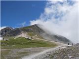
https://www.hribi.net/izlet/hungerberg_parkirisce_pri_postaji_vzpenjace_hafelekarspitze_pespot_s_hungerberga_po_poti_216/59/3275/7817), we head east, following the signs for "Innsbrucker Klettersteig". We cross below the route of the easier short ferrata Geierwally and after about ten minutes of walking from the starting point we arrive below the initial wall of "Innsbrucker Klettersteig".
The initial ascent follows a moderately high vertical wall, where along the steel cable pegs with locally somewhat longer spacings assist us (C). After passing the short western wall of Seegrubenspitze, the path becomes easier and with a secured traverse of the northern slopes above Karwendel we soon find ourselves right below the summit Seegrubenspitze (2350 m), which is only a stone's throw from the path. From the summit we descend along a locally airy, well-secured ridge path (difficulty up to B) to the saddle between Seegrubenspitze and the rocky structure Kaminspitz.
On scree terrain we walk in 10 minutes to the ridge of Östliche Kaminspitze, where a sign directs us back to the secured path. On steep terrain, partly with the help of pegs, we climb to the ridge (B/C) and along the sharp ridge edge approach the panoramic Östliche Kaminspitze (2435 m), where a large summit logbook awaits us. From the ridge summit we descend along a technically easier but still exposed ridge to a narrow notch (B), from which with the help of pegs we climb vertically back to the ridge edge (C). The continuation along the ridge is easier, and the path offers exceptional views of the south-lying Innsbruck and the Karwendel range to the north (up to B). After traversing south below the ridge edge we soon reach a short attractive hanging bridge, which is impeccably secured, and behind it we continue towards Kemacher, which we see ahead in the distance. Soon after the bridge follows a demanding, almost vertical but well-secured descent to a notch (B/C), from which we climb back to the ridge edge (B). The ridge widens somewhat and leads us to a shorter ledge (C), soon after which the path starts descending again along the airy edge. After a short traverse of the southern slopes with the help of pegs we exposedly traverse to the notch below the rocky structure of Kemacher. From the notch we climb over an attractive, less difficult chimney and following the steel cable approach the very panoramic summit (difficulty of the last part up to B).
The only sensible option for descent from Kemacher is continuing along the ferrata to the end of the first part of "Innsbrucker Klettersteig" at Langer Sattel (Long Saddle), which we see to the west below us. The descent is technically somewhat easier than the ascent (spot B/C, mostly A/B), but locally extremely exposed, though steel cables assist us on all key sections. In the lower part of the descent towards the saddle the ridge widens and becomes grassy and easier to pass. From the summit of Kemacher to Langer Sattel approx. 45 minutes descent.
From Langer Sattel we can continue with the second part of "Innsbrucker Klettersteig", which runs over summits, towers and dihedrals of Sattelspitz and is somewhat more demanding but also shorter than the first part (approx. 2 hours of climbing). If we want to return, we can traverse below the Nordkette ridge to Seegrube station and from there return to the valley by funicular. From the saddle it is possible via several paths to descend directly to Hungerburg (fastest partly along path 217 past Höttinger Alm and Umbrüggler Alm, to Hungerburg about 2.5 hours). Although "Innsbrucker Klettersteig" does not reach the technical difficulty of modern sports ferratas (built in 1986, when different standards applied to secured paths) and due to additional aids more resembles classic Dolomite ferratas than modern extreme ones, the path should not be underestimated. The climbing section is long (especially when ascending from the valley), includes numerous ascents and descents and has many quite exposed spots, and the rock in the limestone range is not always solid. Since one can reach almost to the start of the ferrata by funicular and the path offers first-class views of Innsbruck and the picturesque Karwendel, it is very popular. Helmet and via ferrata kit are mandatory.

Along the route: Seegrubenspitze (2350m), Östliche Kaminspitze (2435m)
Photos:
 1
1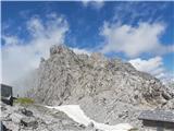 2
2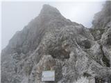 3
3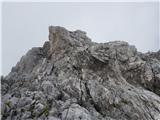 4
4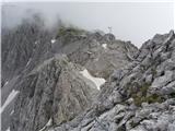 5
5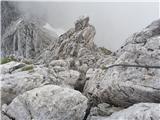 6
6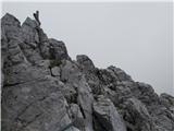 7
7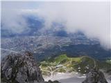 8
8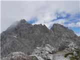 9
9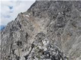 10
10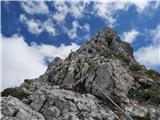 11
11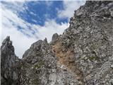 12
12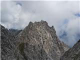 13
13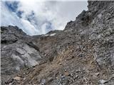 14
14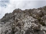 15
15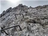 16
16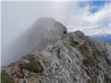 17
17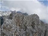 18
18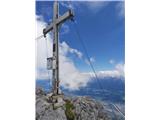 19
19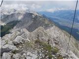 20
20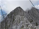 21
21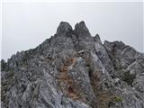 22
22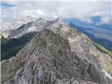 23
23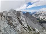 24
24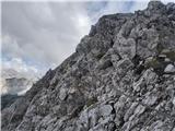 25
25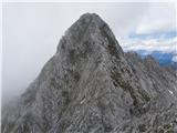 26
26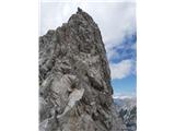 27
27 28
28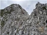 29
29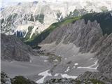 30
30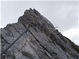 31
31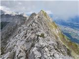 32
32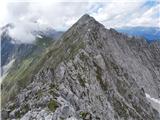 33
33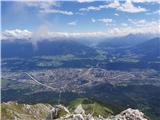 34
34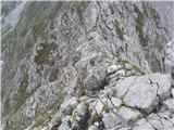 35
35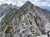 36
36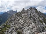 37
37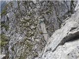 38
38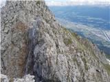 39
39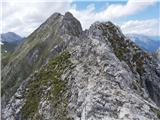 40
40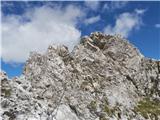 41
41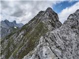 42
42 43
43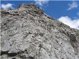 44
44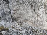 45
45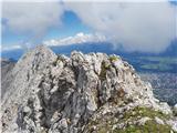 46
46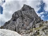 47
47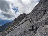 48
48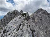 49
49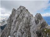 50
50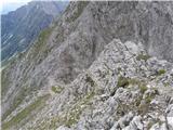 51
51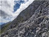 52
52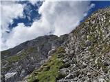 53
53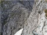 54
54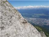 55
55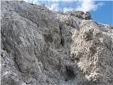 56
56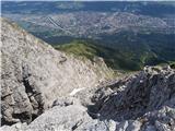 57
57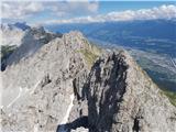 58
58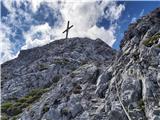 59
59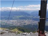 60
60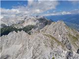 61
61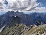 62
62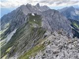 63
63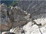 64
64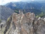 65
65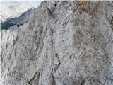 66
66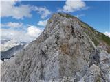 67
67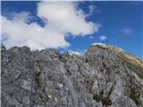 68
68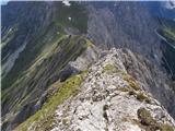 69
69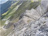 70
70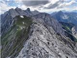 71
71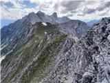 72
72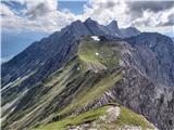 73
73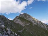 74
74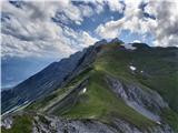 75
75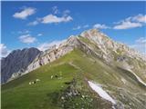 76
76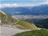 77
77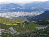 78
78
Discussion about the trip Bergstation Hafelekar - Kemacher (Innsbrucker Klettersteig)
To post a comment you must log in:
If you do not yet have a username, you must first
register.