Bukovnik - Velika Raduha (via Durce)
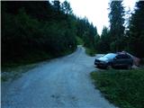
Starting point: Bukovnik (1327 m)
| Latitude/Longitude: | 46,43400°N 14,73710°E |
| |
Route name: via Durce
Walking time: 2 h 50 min
Difficulty: easy marked way
Elevation gain: 735 m
Elevation difference along the route: 770 m
Map: Kamniške in Savinjske Alpe 1:50.000
Recommended equipment (summer): helmet
Recommended equipment (winter): helmet, ice axe, crampons
Views: 113.568
 | 4 people like this post |
Access to starting point:
A) We drive to Luče (to here from Mozirje or from Kamnik over the mountain pass Volovljek (Kranjski Rak)), then continue driving towards Logarska dolina. In the village Solčava we leave the main road towards Logarska dolina and continue driving right in the direction of Podolševa, mountain pass Spodnje Sleme and Črna na Koroškem. Further the road loses its asphalt covering, and after a few kilometers at the crossroad in Podolševa we turn right towards Črna na Koroškem. The road, which further mostly ascends diagonally, brings us after some time to mountain pass Spodnje Sleme. Here we turn right in the direction of the mountain hut Koča na Grohatu and farm Bukovnik (farm Bukovnik is located at an altitude of 1327 meters and is considered the highest-lying farm in Slovenia) and continue the ascent on a macadam road, which a few 100 meters higher brings us to the next crossroad. At the mentioned crossroad a forest road closed for public traffic branches off slightly to the left, which leads towards Koča na Grohatu, and straight the road continues towards the aforementioned farm. We park in an appropriate place near the crossroad.
B) We drive to Črna na Koroškem (to here from Ravne na Koroškem or from Šoštanj over mountain pass Spodnje Sleme), then continue driving towards Luče. Initially still asphalt road, higher it becomes macadam and brings us to the crossroad of several roads on mountain pass Spodnje Sleme. Here we turn left in the direction of Koča na Grohatu and farm Bukovnik (farm Bukovnik is located at an altitude of 1327 meters and is considered the highest-lying farm in Slovenia) and continue the ascent on a macadam road, which a few 100 meters higher brings us to the next crossroad. At the mentioned crossroad a forest road closed for public traffic branches off slightly to the left, which leads towards Koča na Grohatu, and straight the road continues towards the aforementioned farm. We park in an appropriate place near the crossroad.
Route description:
From the starting point, we head onto the upper road, which is closed to public traffic with a traffic sign (straight to farm Bukovnik), after approximately 100 meters we arrive at a barrier that also physically prevents further driving. A little further a nice view opens towards farm Bukovnik and Kamnik Savinja Alps, when we return to the forest the path splits.
We continue slightly left on the marked footpath (straight path along the road), which further crosses slopes to the right, most of the time gently to moderately ascending. During the crossing the path leads us over a few shorter steep sections, where it is nicely arranged and partly fenced, technically not demanding. After some time we step out of the forest onto mountain pasture Grohot, where we return to the road, and only a few dozen steps of easy walking separate us from the Koča v Grohotu pod Raduho hut.
From the hut we continue in the direction of Durce and Raduha, where initially we still walk on a poor road, or higher on a cart track.
At the Koča GRS the cart track ends definitively, we continue on the path that turns left. There follows some ascent through occasionally sparse forest, then we arrive at a marked junction, where we continue left towards Durce (right climbing path to Raduha).
The path ahead ascends quite steeply and turns increasingly towards the east. The increasingly scenic path then brings us to the scree under the walls of Mala Raduha, where we continue straight (slightly right the abandoned old path is still visible). There follows crossing of the scree, after crossing the gully we enter the belt of dwarf pines, through which a nicely arranged path leads us. On the mentioned path, which ascends steeply, after approximately 10 minutes of further walking we arrive at a marked junction located slightly east of Durce.
From the junction we go right towards Raduha (left Lanež and eastern path to Koča na Loki pod Raduho) and quickly arrive at Durce, where a path to the ridge used to arrive.
Here a path branches off to the left downwards towards Koča na Loki, we continue straight. The path ahead ascends transversely through the belt of dwarf pines and further leads us across the sunny slopes of Mala Raduha. A little further the usual path from Koča na Loki joins from the left, we continue straight towards Raduha. There follows a short descent, then the path begins to ascend towards Velika Raduha. After a few minutes of further ascent the climbing path from Koča v Grohotu joins from the right, we continue straight and in a few minutes of further walking step onto the scenic summit of Velika Raduha.
Bukovnik - planina Grohot 0:40, planina Grohot - Durce 1:25, Durce - Velika Raduha 0:45.
The description refers to the condition in July 2019, pictures from Durce onwards are older.

Photos:
 1
1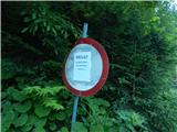 2
2 3
3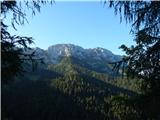 4
4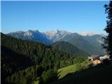 5
5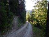 6
6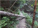 7
7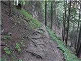 8
8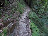 9
9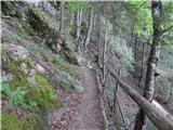 10
10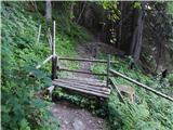 11
11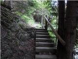 12
12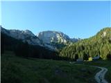 13
13 14
14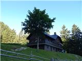 15
15 16
16 17
17 18
18 19
19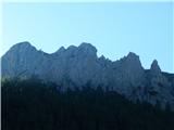 20
20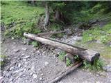 21
21 22
22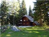 23
23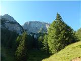 24
24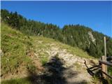 25
25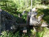 26
26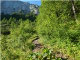 27
27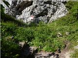 28
28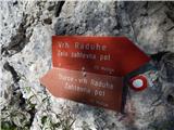 29
29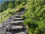 30
30 31
31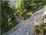 32
32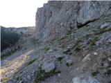 33
33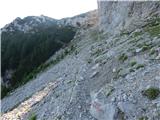 34
34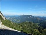 35
35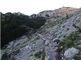 36
36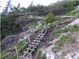 37
37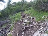 38
38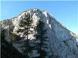 39
39 40
40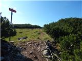 41
41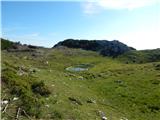 42
42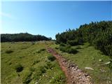 43
43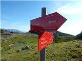 44
44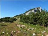 45
45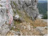 46
46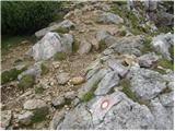 47
47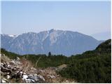 48
48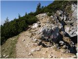 49
49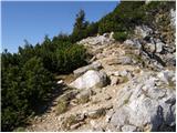 50
50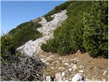 51
51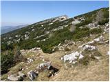 52
52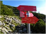 53
53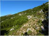 54
54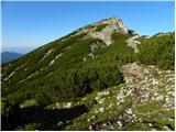 55
55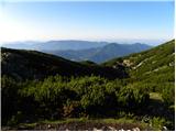 56
56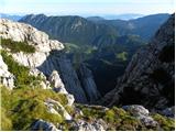 57
57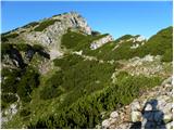 58
58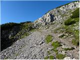 59
59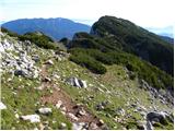 60
60 61
61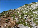 62
62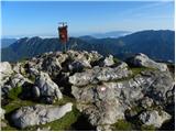 63
63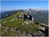 64
64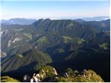 65
65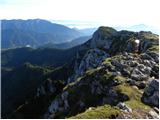 66
66 67
67
Discussion about the trip Bukovnik - Velika Raduha (via Durce)
Show older messages
|
| Karatko28. 03. 2008 |
I am interested in how passable the road is in the direction of the hut at Grohatu and Bukovnik.
Is the hut open? I am coming from Croatia. So I do not have to refuel.
|
|
|
|
| Klin28. 03. 2008 |
They plow the road after every snowfall. For the hut opening, best to ask the warden at tel. 041/690-011
|
|
|
|
| alesvrscaj10. 08. 2008 |
I just returned from Raduha. I believe this trail cannot be marked as an easy marked trail. The markings on the trail also warn that it is demanding. On the scree there are some very narrow passages, the terrain is very wet this year, so greater caution is needed especially for less experienced (some were in bad sneakers). Since families also use the trail, the actual difficulty must be stated, and even the exit to Durce saddle is quite awkward. On the scree, given the proximity of the wall, I would recommend helmet use (many hikers had it).
|
|
|
|
| geppo11. 08. 2008 |
The trail is marked as demanding - a lot has already been written about the objectivity and subjectivity of ratings (so I wouldn't open that topic). For families (which means, I suppose also presence - if I understand correctly children) already the sign >DEMANDING TRAIL< means that the trail is not completely easy (but it's not difficult either!!) I wouldn't comment on >BAD SNEAKERS< (even >GOOD< ones are not for this trail) and because of them it's not necessary to VALUE THE TRAIL EVEN MORE WITH HIGHER DIFFICULTY, WHICH IT IS NOT!!
LP
|
|
|
|
| Gozdana14. 08. 2008 |
I agree with one of the previous commenters that the trail should be marked as difficult, and the pitons and cables should also be extended - they are too short and the trail over the scree slope should be arranged.
|
|
|
|
| geppo15. 08. 2008 |
Gozdana!
The trail is marked as DIFFICULT TRAIL!!!
At the trail junction, the trail LEFT THROUGH DURCE - DIFFICULT TRAIL
To the right though VERY DIFFICULT TRAIL!
So the trail is declared as >DIFFICULT<
Securing and arranging the trail through the scree is a somewhat demanding task - the scree has been piled up by erosion, scree debris at the foot of the wall. Various factors affect it (avalanches, water...) and the scree condition is unstable and changing.
In such scree, arranging a stable trail is practically impossible because the condition changes day by day.
At least personally I think that if we decided to move in >unspoiled< nature, on mountain trails we must be prepared for difficulties arising from this (fallen trees, unregulated scree...
I do agree however that the safety gear installed for a safer trail and serving that purpose - IS IN PERFECT CONDITION!!
Or rather, that damages from various influences are repaired promptly!
Best regards
|
|
|
|
| NEIC00828. 09. 2008 |
Did this tour today. Trail snowy, risk of slipping, but still doesn't deserve more than slightly difficult. Probably not even that in dry conditions.
|
|
|
|
| kranjc923. 04. 2009 |
Please, does anyone know what the path from Robanov kot past Račnik is like?
|
|
|
|
| Rajty29. 06. 2010 |
For the descent via Durce at the sign just below the summit head towards Koča na Loki. The Grohot marker leads us to the climbing path, which however is not marked.
|
|
|
|
| gasilec3. 07. 2010 |
Today (03.07.10) during the descent from Raduha via Durce towards the Koča na Grohatu hut I was pleasantly surprised by the new trail made by diligent path markers. It branches off from the existing trail in the upper part of the scree slope below the cliffs of Mala Raduha and turns left onto the western slope of Durc, leading us effortlessly to the mentioned pass. It is very welcome for descent, as there are no difficult sections.
The section of the previous (old) trail to the pass is now closed.
|
|
|
|
| Micky9. 07. 2010 |
Yes, I was one of the last to "climb" through Durce, as there were no more cables and protections. Later I learned from the via ferrata builders that yesterday the entire wall collapsed with the cables and they had to make a new path. They successfully did it over the weekend. Now the path is really easy.
Yes, going up worked, but going down would have been tricky where we went up.
|
|
|
|
| petrah77713. 09. 2010 |
Yesterday (12.09) we were on Raduha with mine, it was quite windy and cold. This new path is really fun. We continued the path to Koča na Loki and then back through Durce to Koča na Grohotu.
|
|
|
|
| garmont2. 06. 2011 |
Given that the new path over Durce is routed elsewhere, I suggest removing the note " partially demanding path ".The new path is suitable for all hikers.The old path is closed, safety gear has been removed, so officially there is no more old path over Durce.Best
|
|
|
|
| sonja 7019. 09. 2011 |
On Saturday 17.9.2011 I was with my daughters on Raduha. The path over Durce is very pleasant and not too demanding, so it's also suitable for children. Really nice hike.... Best
|
|
|
|
| garmont26. 11. 2011 |
The forum entry "Partially difficult trail" hasn't been removed yet and unfortunately on site the signs still say "Difficult trail", which it certainly isn't after the new rerouting under Durce.
Regards
|
|
|
|
| mortysus27. 11. 2011 |
Was on the summit on Saturday and finally soaked up the sun  . It was really wonderful, path super, weather super ... . It was really wonderful, path super, weather super ...
|
|
|
|
| izidor22. 02. 2012 |
Has anyone walked up there and can tell how the conditions are? Thanks!
|
|
|
|
| Janezs2. 02. 2012 |
On 26.01.2012, Romana and I hiked via Grohat and Durce to Raduha. On the right side of Grohat looking from bottom to top, there was quite a lot of snow in certain places, even wind-packed, towards the direction of Lanez it was always less. Durce were completely blown bare - dry. On the newly made path again, quite some snow. Today it's probably completely different, also quite a lot of new snow. Best to check on site. The actual situation interests me too, so I'll go check soon. (It surely won't be more than that.) UNDERSTAND THESE ARE NOT CURRENT CONDITIONS but 26.01.2012 below Raduha you can look at some pictures from then Regards
|
|
|
|
| izidor23. 02. 2012 |
Thanks for the info Janez, maybe someone else will go and provide info, I'm not going this weekend let the weather stabilize a bit, it would be interesting to know how the road to Bukovnik is, if chains are needed etc. thanks anyway. Best regards.
|
|
|
|
| Janezs3. 02. 2012 |
The road is always well maintained, always gritted, at least to the ridge. And to the farm no problem, sometimes a bit less gritted. Regards
|
|
|
|
| seinfeld10. 09. 2012 |
On Saturday 8 September we did this trip. Two adults, two kids 11 and 13 years. I haven't walked such a well-maintained path yet. Markings and signs everywhere, the path phenomenally arranged, almost too much. Up we walked 2h45min.
But the multitude of cars at the hut at Grohat disturbed me quite a bit.
|
|
|
|
| roberthr21. 10. 2012 |
We were there yesterday and the path via Durce is great and really nicely maintained.
|
|
|
|
| cmilk14. 07. 2013 |
Hello,
today I was on Velika Raduha and at the summit had an unpleasant surprise, as the stamp was missing.
The caretaker of the hut at Grohat said that someone must have taken it today. I really don't understand how someone can be so primitive!
|
|
|
|
| smatjaz19. 07. 2013 |
Can anyone tell if the path Loka - Raduha - Grohat - Loka is suitable for a 13-year-old, at least regarding pegs and safety wires??? On Sunday I plan to do this path with my son, but I'm not too sure how he would handle the pegs, we do have safety gear. Thanks
|
|
|
|
| otiv20. 07. 2013 |
As it seems, you haven't been to Raduha yet. Namely, from Raduha towards Grohat there are two paths: one via Durce, which is not demanding, and another from the top of Raduha, which is demanding. If your son has never walked demanding paths, it's better to go via Durce.
Good luck and have a nice day on Raduha! It's probably all in bloom now.
|
|
|
|
| andrej7820. 07. 2013 |
From Raduha there are 3 paths, namely also Hojnikova pot via Lanež... If you haven't gone yet, I recommend it...
|
|
|
|
| otiv20. 07. 2013 |
I know Andrej78, I just don't like carrying a helmet in the mountains and avoid such paths where there is a lot of scree on the path and something can easily trigger.
Best regards!
|
|
|
|
| CarpeDiem24720. 07. 2013 |
@SMatjaž, as the predecessors have already said, via Durce (from Velika Raduha there is quite a while a common path as for the hut at Loka) it won't be problematic for the descent to Grohat. While the descent via the climbing path I really advise against if the kid has no experience with these things. Otherwise, I think the rating "very demanding" is exaggerated, but for the descent the difficulty is immediately somewhat higher.
|
|
|
|
| neph20. 07. 2013 |
CarpeDiem247, the secured path to Raduha deserves the name "very demanding" according to all criteria I know. You probably meant that compared to other secured paths (which have the same name) it is not overly demanding - I agree with that.
|
|
|
|
| smatjaz20. 07. 2013 |
Thank you all very much for the answers that mean a lot to me, namely the little one hasn't been in the wall and pins yet, even though we have complete safety equipment I don't know how he'll handle it. We'll choose the path via Durce. Thanks again everyone.
|
|
|
|
| smatjaz21. 07. 2013 |
Today I did the path from Loka to the summit, then over Durce to Grohat and back again over Durce to Loka. I have to say it was a fantastic trip, thanks again for the advice. The path didn't seem demanding to us, except after so much walking, back from Grohat a bit tiring. The stamp on the summit still isn't there and they don't know when it will be. The only stamp for the conquered summit is in the hut at Loka, they don't have it at Grohat - checked.
|
|
|
|
| SunnyDay17. 07. 2014 |
Are the SPP stamps back by any chance?
|
|
|
|
| možiček18. 07. 2014 |
All three stamps in the Raduha area are where they should be.
|
|
|
|
| Marko8318. 07. 2014 |
In the box there was only one last week.
|
|
|
|
| maks5729. 07. 2015 |
Please advise regarding Velika Raduha. In the logbook of the Slovenian Mountain Trail there are Velika Raduha, koča na Loki pod Raduho and koča v Grohatu pod Raduho. Is a circular tour intended for all three stamps? How much time distance is there then from one hut to the other? If it is really a circular tour, via which hut to start the tour?
Thank you in advance for the answers.
|
|
|
|
| Ninđa29. 07. 2015 |
If the wish is to get all three stamps at once, otherwise it doesn't go without a circular tour. In this case start and finish in Rogovilec. Marked over 9 hours. If you have two cars it goes faster. In this case leave one car e.g. at planina Loka or at Snežna Jama, drive with the other to Bukovnik and past Grohat to Velika Raduha and down to koča na Loki to the first car. Then with the first car back to the second Or vice versa. Depending on from which direction you arrive. Marked approx. 4-5 hours.
Or you can do two tours. Once Loka - Velika Raduha. Second Grohat - Velika Raduha
Does anyone have any other advice?
|
|
|
|
| valerija11229. 07. 2015 |
The tour can be nicely done in one day, it goes a bit down, a bit up. We started at the Bukovnik farm to the hut on Grohat, via the climbing path to the top of Raduha, descended to the hut on Loki, and back via Durce. The paths are beautifully marked and secured. Special praise for the new path via Durce. And also praise for the friendly caretakers in both huts. Good luck.
|
|
|
|
| Domch30. 07. 2015 |
In my opinion, the best is from Bukovnik to Grohat, up the secured path and descent to Koča na Loki, then ascent to Durce, here I recommend a detour right to the last peak of Raduha-Lanež and then back to Durce and descent back to Bukovnik. You can count on about 7-8 hours total.
|
|
|
|
| Ninđa30. 07. 2015 |
Or as @valerija112 and @domch wrote but with the addition of Lanež
|
|
|
|
| maks5710. 11. 2015 |
On Saturday my wife and I are heading to Velika Raduha. We haven't decided yet which path. I'm interested where to get stamps for the hut on Loki or for the hut on Grohatu?
|
|
|
|
| Saš196711. 11. 2015 |
PD Mežica manages the hut on Grohatu, PD Luče manages the hut on Loki. They probably know best there.
|
|
|
|
| maks5711. 11. 2015 |
Thank you very much, Saš1967! We decided to take the path via Durce and learned from PD Mežica that the hut at Grohat is open on weekends.
|
|
|
|
| maks5711. 11. 2015 |
Wrong information! I spoke with the caretaker, who says he's on vacation, so there's no possibility of getting a stamp. Too bad!
|
|
|
|
| maks5711. 11. 2015 |
The president of PD Luče assured me that the hut at Loki will be open on Saturday.
|
|
|
|
| TheSpecialOne6. 10. 2016 |
Hello. Has anyone been to Raduha in the last few days? I'm wondering if there's any snow yet? Thanks
|
|
|
|
| denist7. 12. 2016 |
planning to combine Olševa with Raduha on Saturday morning, assuming about 5-6 hours for an active hiker?
|
|
|
|
| piotr7. 12. 2016 |
This time is more for runners; otherwise if you start at
Sp. Sleme, it's 2-3 hours walk to each summit, plus returns, so the day will barely be long enough.
|
|
|
|
| dr_6357. 12. 2016 |
If you drive to Rogar, then hike to Olševo (Govco), then descend, and back to the car to Bukovnik. From Bukovnik to Raduha and back. Well, then the tour works for such a short day. Still need to hurry.
|
|
|
|
| Janezs7. 12. 2016 |
You have a hundred options, leave the car at the last farm in Bistra, then go to Knezova planina, past planina Vodul, to planina Javorje. Here you choose Loko or not, go to Raduha. Descend to Grohot. lower sleme, upper sleme, Govca. Then back to slemena and Ježevo, Bistra and you're at the car. If you don't want to walk the same way both directions, you need a driver or 2 cars. Regards, Janez
|
|
|
|
| denist7. 12. 2016 |
Between the hills I would drive by car, Raduha to Bukovnik, for Olševa as I remember there's a right turn at ''križišče'' for Olševa (from direction Črna na Koroškem).. otherwise at križišče from Bukovnik direction straight.
Thanks for the tips
|
|
|
|
| Janezs8. 12. 2016 |
Between lower and upper sleme there's a ramp or chain, so you'll turn back after 500 m. Now logging is taking place, the road is open but bad. For this crossing you spend barely half an hour. But I've often crossed these two "mountains" together, since driving for one peak is too much.
Decide for Koroški K-24 and connect all Koroška hills. Peco, Uršlja, Smrekovško pogorje, Raduha and Olševo and close the circle. Marko and I walked this last weekend.
|
|
|
|
| denist8. 12. 2016 |
@Janezs, hehe actually I'm preparing for this but most likely in spring so I'll have more daylight available because I'll go alone unless I find a duo
|
|
|
|
| Janezs9. 12. 2016 |
In 2016, 45 hikers from K-24 passed through, including 7 women. There were many repeat hikers as well. Regards.
|
|
|
|
| denist10. 12. 2016 |
Today I spent 4 hours and 45 minutes for both peaks mentioned above, surprised myself
|
|
|
|
| denist16. 04. 2017 |
There is still quite a lot of snow over Durce, the problem is that the snow is soft and wets summer gear a bit ..on the way back it started snowing heavily, lower down it stopped
|
|
|
|
| daver28. 12. 2017 |
Hi. Has anyone gone on this route to Raduha in the last days?
Is it normally passable? Of course with crampons and ice axe....
|
|
|
|
| Janezs28. 12. 2017 |
Now you'll also need snowshoes or skis, quite a bit of snow has fallen, and it will snow more. Best regards.
|
|
|
|
| brezpotja29. 12. 2017 |
Hi!
I was there on Friday, 22.12.2017 with touring skis. I went towards Durce and there was 20-30 cm of powder, below an icy crust. Now quite a bit of new snow has fallen so I advise against this route - high avalanche danger. Need to wait for the snow to settle and consolidate. Safe steps!
|
|
|
|
| čara24. 09. 2018 |
Ah, I wish I had looked at these photos beforehand and not blindly trusted my mom and brother who know the path and are aware of my fear...They two went up the secured path, I headed for the difficult path and soon it became too demanding for me. I have a strong fear of heights, looking up or down, my legs get wobbly...I barely continued anyway (because, I didn't know how to go back). Mistake. I should have stayed before the scree and slowly back. But instead, with pulse around 130 and shaking legs, I continued all the way to the "terrace", where my upward ordeal ended, I still didn't dare to the summit. Back down. Even worse. I should have taken the direction to Loka on the way back, which is supposedly easier...I believe that for many the path is really easy, as marked on the web.
A boy not yet 4 years old mastered it without problems and fear via the secured path, with mom in tandem...On the path itself there is a sign "difficult path". Although the previous path was significantly more demanding, it is too demanding for those of us not used to heights and who almost have a phobia. Too bad I didn't inquire beforehand. Because there's a desire to overcome the fear, but in this way I didn't do myself a favor.
|
|
|
|
| garmont24. 09. 2018 |
The path description is completely wrong. The described path has been closed for several years.
|
|
|
|
| črnozanohtam29. 04. 2019 |
Has anyone by chance hiked this path in the last few days?
|
|
|
|
| Janezs30. 04. 2019 |
In such conditions one does not go there "accidentally"
|
|
|
|
| trdi4. 05. 2019 |
Well, this path, since it no longer goes directly up the gully from the end of the scree but a new path has been built to the left of the gully for several years already (therefore new pictures are needed), is easy and undemanding and is correctly marked as easy in accordance with the general categorization. Whoever finds this path challenging in terms of exposure has no business on two-thousanders.
|
|
|
|
| dleskovec5. 05. 2019 |
It's true as "trdi" says; already in 2011 a nice bypass path on Durce was built. Therefore the pictures from the description (17-22) are not up to date; Tadej, I'm attaching a few of mine, maybe suitable for publication.
|
|
|
|
| jprim5. 05. 2019 |
Nice comments, but ... When I was on this path last year, it needs repair and renovation ... the protruding steps are no longer comfortable walking downhill. Hey, whoever is responsible for this path, get to work a bit.
Regards!
Jelica
|
|
|
|
| jprim5. 05. 2019 |
Sorry - really a beautifully made path in 2011, but what about 2019 ...
Best regards!
|
|
|
|
| Janezs5. 05. 2019 |
In my opinion, since 7 years have passed (2011), renovation is imminent. Regards.
|
|
|
|
| čara6. 05. 2019 |
I think the problem is pushing a complete beginner unaccustomed to mountains, paths, slopes etc. onto this trail. Need to start gradually. Easier in a small group than alone (others on the secured path)... The scree crossing can cause the most trouble. But if you have someone ahead going without issues, fear decreases for most others too. Well, that "lojtra" was quite rickety last year, I nearly yelped whether everything would collapse. The path is well built. Who volunteers to repair it?
|
|
|
|
| trdi6. 05. 2019 |
The fact is that Raduha, alongside e.g. Peca, Viševnik, Debele peči etc., among the most visited, is one of the easiest two-thousanders. For complete beginners first Šmarna gora, then some Dobrče, Kriške gore, Blegoši, Ratitovci etc. Definitely don't send a complete beginner to two-thousanders, as you'll ruin hill walking for them... Mileage in mountains builds gradually, then everything becomes easier, fear of heights decreases with every path...
|
|
|
|
| dprapr7. 05. 2019 |
Do you need a ladder for Raduha?
They make extendable ones...
|
|
|
|
| Domch7. 05. 2019 |
I wouldn't say Raduha ranks among the easier two-thousanders, especially not from the north side where there are several difficult paths (secured, Hojnikova,...), not to mention slipping and avalanche danger in snow. This mentioned path is no longer in use, but it can be done with some effort and great care; mandatory winter gear at this time of course.
|
|
|
|
| mirank7. 05. 2019 |
Can you please stop harping on some terrible difficulty on this mountain? There simply aren't any on the marked trails there!
|
|
|
|
| trdi7. 05. 2019 |
The marked paths were meant, i.e. this described path via Durce in summer without snow, which is correctly designated as easy path, true the path from Loka is even easier. The marked climbing path also ranks among the easier ones, perhaps only the one on Peca is easier.
|
|
|
|
| jprim8. 05. 2019 |
Hard and peaceful
A few years ago I thoroughly studied the book that
talks about the difficulty of the path, so I wouldn't talk about any path differences. My opinion is that Peca and Raduha are in the same category, and the descriptions in the book are the same.
The path itself is very demanding, but in terms of climbing paths, they are marked as easier.
Best regards!
|
|
|
|
| Tadej18. 07. 2019 |
The path description has been updated.
|
|
|
|
| tomo_kugy21. 07. 2019 |
Today with my daughter I walked the mentioned path - up the climbing one, down through Durce. Unfortunately the path from Durce to the scree is in quite poor condition, most wooden steps are broken or rotten. It's no problem to go a bit left or right, but if there are steps there already, it's important that they are intact and sound, because in the condition they are now, it would be better if they weren't there.
Safe steps to all.
|
|
|
|
| Berstuk18. 01. 2021 |
Has anyone been there these days? How is it up there?
|
|
|
|
| ana_banana10. 03. 2024 12:15:27 |
Has anyone gone on this path these days?
|
|
|
|
| hwe.hwe31. 07. 2024 19:05:04 |
Hello, I'm interested (given the recent rain) in how passable the road to the starting point is?
Thanks
|
|
|
To post a comment you must log in:
If you do not yet have a username, you must first
register.