Dolina Dobri do - Bobotov kuk
Starting point: Dolina Dobri do (1722 m)
| Latitude/Longitude: | 43,10644°N 19,02500°E |
| |
Walking time: 2 h 45 min
Difficulty: difficult marked way
Elevation gain: 801 m
Elevation difference along the route: 820 m
Map: Durmitor 1 : 22000
Recommended equipment (summer): helmet
Recommended equipment (winter): helmet, ice axe, crampons
Views: 4.491
 | 3 people like this post |
Access to starting point:
About 4 km south of Žabljak we find a junction from the Žabljak-Nikšić road to the Žabljak-Sedlo-Trsa-Plužine road (the turn-off is currently not marked!) and drive along a flat, high-mountain, fully asphalted road over the Sedlo saddle to the Dolina Dobri do, where there is a small parking lot on the right next to the road and a sign next to it inviting to Bobotov kuk (over 17 km from Žabljak, about 3 km descent from Sedlo).
Route description:
From the parking lot above the Dolina Dobri do to the junction near Zeleni vir lake, where the second steep section of the tour begins, we generally walk north to northeast. First we steeply ascend from the parking lot over the first step, then the terrain opens up widely and we circle the vast Urdeni do valley along the right bank. At the other end of the valley we steeply climb over grassy steps that lead us to the Mliječni do valley. From there we continue more gently over a few steps to a larger path junction a few minutes above Zeleni vir lake (a gentle descent leads to the lake, about 5 minutes). To here 1:15.
We continue upward over the steps of the southern slope of Bobotov kuk (one fixed cable in the lower part). The slope is steep and long. In zigzags we ascend the rockier parts, higher up there are more and more grassy sections. Upon reaching the saddle right below the summit pyramid, a view opens toward Žabljak. From the saddle we continue left in a gentle ascent over scree terrain until we reach the saddle left under the summit pyramid. There we cross to the west side, far below us the valley with Škrčko lake opens up. On the west side a short exposed traverse to the left awaits first, then ascent through a short gully, above it a gentler passage right to the summit rocks. Some fixed cables assist over the summit rocks, above them just a few steps to the top. From the junction to the summit 1:30.

Along the route: jezero Zeleni vir (2028m)
Photos:
 1
1 2
2 3
3 4
4 5
5 6
6 7
7 8
8 9
9 10
10 11
11 12
12 13
13 14
14 15
15 16
16 17
17 18
18 19
19 20
20 21
21 22
22 23
23 24
24 25
25 26
26 27
27 28
28 29
29 30
30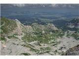 31
31
Discussion about the trip Dolina Dobri do - Bobotov kuk
|
| felix31. 08. 2022 19:44:33 |
On Monday visited this peak via this path. Unique views of Durmitor mountain range with specially shaped massifs. The path to the saddle is a bit uncomfortable when wet.
|
|
|
To post a comment you must log in:
If you do not yet have a username, you must first
register.