Konec ceste na Pokljuki - Triglav (via Kredarica)
Starting point: Konec ceste na Pokljuki (1312 m)
| Latitude/Longitude: | 46,33860°N 13,90450°E |
| |
Route name: via Kredarica
Walking time: 6 h 15 min
Difficulty: very difficult marked way
Elevation gain: 1552 m
Elevation difference along the route: 1710 m
Map: Triglav 1:25.000
Recommended equipment (summer): helmet, self belay set
Recommended equipment (winter): helmet, self belay set, ice axe, crampons
Views: 88.395
 | 7 people like this post |
Access to starting point:a) Leave the Gorenjska motorway at the Lesce exit, then follow signs for Bled and Pokljuka. Continue through Gorje and past the Zatrnik ski slope to Rudno polje on Pokljuka, where there is a large paid parking lot, nearby also military barracks and shooting range. From here continue straight on the gravel road, which a little further brings us to a junction, where we continue right (left Uskovnica). Follow this road to the former parking lot Za Ribnico, located at the end of the road (nearby are mountain signs for planina Konjščica).
Parking at the end of the road is now prohibited, so park already at Rudno polje, which extends the route by about 40 minutes, but it is more appropriate to choose the marked path that starts already at Rudno polje.
b) From Železniki or Podbrdo drive to Bohinjska Bistrica, then continue driving towards Bled. Shortly after the Petrol gas station, located just behind Bohinjska Bistrica, continue left towards Pokljuka and Jereka. The road first ascends steeply, then after Koriti gradually flattens and brings us to a junction at the bus stop, where we continue right towards Pokljuka, Koprivnik and Jereka (straight Srednja vas). Immediately after the junction we arrive at Jereka, but from the junction in front of the church we continue straight towards Pokljuka (left Podjelje). After Jereka the road begins to ascend more steeply again, higher it flattens and continues along Mrzli potok. When we join the road from Bled go left and drive to Rudno polje, where there is a large paid parking lot, nearby also military barracks and shooting range. From here continue straight on the gravel road, which a little further brings us to a junction, where we continue right (left Uskovnica). Follow this road to the former parking lot Za Ribnico, located at the end of the road (nearby are mountain signs for planina Konjščica).
Parking at the end of the road is now prohibited, so park already at Rudno polje, which extends the route by about 40 minutes, but it is more appropriate to choose the marked path that starts already at Rudno polje.
Traffic regime in the Pokljuka and Uskovnica area from 15.6. to 15.10.
Route description:
From the former parking lot at the end of the road, continue on the wide and initially ascending cart track towards Planina Konjščica. The cart track, which immediately enters dense forest, soon flattens and after a few minutes of easy walking turns into a footpath that continues along the left bank of the Ribnica stream. When the path approaches the stream completely, it turns slightly right and ascends more steeply. Higher up, the path flattens and leads us from the forest to the lower edge of the vast Planina Konjščica. Here the path turns slightly left, crosses the stream and after a few more steps brings us to the cheese dairy on Planina Konjščica.
From the cheese dairy, continue on the pleasant path that in a few minutes of gentle ascent brings us to the upper edge of the meadow. Here the path enters the belt of dwarf pines and shrubs and gradually begins to ascend more steeply. In the upper part of the ascent towards Jezerca, the path from Rudno polje joins from the right, we continue straight on the moderately steep path, which in a few more minutes of walking brings us to Jezerca, where the path flattens and turns left (here the path to Srenjski preval branches right).
Follow easy walking to the sign indicating the central area of TNP, then the path begins to ascend moderately along the torrent, initially still a streamlet. Higher up, the path crosses to the right side of the torrent (viewed from the ascent direction) and then transversely ascends to Studorski preval, from which we have a nice view of the mountains above Bohinj.
Here a demanding path from Srenjski preval joins from the right, and from our path unmarked trails also branch to Ablanca and Veliki Draški vrh.
From the saddle, first descend steeply for a short time, then the path turns right, and we then cross the slopes to the left for a longer time with some shorter easy ascents and descents. From the slopes of Veliki Draški vrh we gradually arrive at the slopes of the massive Tosc, we continue with nice views past the branch of the path to Tosc and the junction where the path from Uskovnica also joins from the left.
At all junctions, including the one where the partly abandoned path via Planina Zgornji Tosc joins, continue straight, the path gradually brings us to steeper and also precipitous southwest slopes of Tosc mountain, where there was a landslide a few years ago, so additional caution is needed due to falling rocks. Across the precipitous part runs a fairly wide path, so there are no special difficulties in this section, when the slope becomes less steep, the path from Stara Fužina or Voje valley also joins from the left.
Continue straight on the wider marked path towards Triglav, which continues north, leading us along the western slopes of Tosc, the still gentle path brings us across some scree to Vodnikov dom on Velem polju, where the next junction is.
Here too continue straight towards Triglav, the path begins to ascend transversely along the slopes of Vernar, higher it also becomes technically demanding. Follow some traversing where a wire cable assists us, higher we arrive at a steep jump, where with the help of numerous pegs and wire cable we ascend stone steps.
The path ahead flattens, the slope becomes less steep and near Konjsko sedlo also somewhat more grassy.
Easily descend to Konjsko sedlo, from the marked junction at the saddle head straight on the path towards Triglavski dom na Kredarici and Staničev dom pod Triglavom (left Dom Planika pod Triglavom, right Krma valley), just a few steps ahead the path forks again.
Continue slightly left towards Kredarica (slightly right Dom Valentina Staniča) and then transversely ascend across numerous gullies, where crossing them is generally not demanding. Further on the path becomes technically more difficult and on some sections some safety devices assist us for easier and safer progress, mainly wire cables, some pegs too.
At an altitude of just under 2300 meters, we join the technically easier path from Krma valley, we continue left towards Kredarica and Triglav.
When a few minutes further the path flattens even more, the path branches left past Snežna konta and over Štapce towards Dom Planika pod Triglavom, we continue right and first continue quite gently, then ascend to the ridge above Vrh Snežne konte, the summit of which we saw from below during the ascent via Kalvarija.
Here the path becomes steeper again, we follow such path all the way to Triglavski dom na Kredarici.
In front of the hut, at the chapel of Marija Snežna, the path from Kot valley joins from the right, passing Dom Valentina Staniča, we continue along the left side of the hut and behind the hut the path from Vrata valley joins from the right, namely the paths over Prag and Tominškova pot.
Continue left towards Triglav and on the still technically undemanding path descend to Ledeniški preval, from where we begin to ascend towards the wall of Mali Triglav. Here follow the marks and the larger mark visible from afar, near which the very demanding path to Triglav begins.
Initially ascend on still not very steep slope with the help of some pegs and individual wire cables, when we arrive at the wall of Mali Triglav we begin to ascend transversely to the left, where wire cables were added to the pegs a few years ago, so it is possible to self-belay with a via ferrata set. Follow some quite steep and exposed ascents, where we take care not to slip, on the section where there is scree on the path we must also be careful not to dislodge rocks as it can be deadly dangerous for hikers below us. The path ahead is quite narrow and with a larger number of visitors queues can form due to difficult passing between hikers.
Higher the steepness eases and from the left the path from Dom Planika pod Triglavom joins, namely the path over Mali Triglav, which we reach just a little further.
From Mali Triglav follows some gentle descent along occasionally less exposed ridge, when we start ascending again the ridge narrows, the path becomes precipitous on both sides. Further follow some quite steep ascents, the path is mainly well secured with wire cables and individual pegs, up to the summit on nice days queues are possible due to passing. Below the summit the path becomes less demanding, still precipitous though. Just below the summit a path branches slightly left towards Staničevo zavetišče (emergency bivouac carved into the Triglav massif), we follow the still cautious but last few meters less steep path to Aljažev stolp, located on the summit of Triglav, the highest mountain of the Julian Alps and Slovenia.
Start - Planina Konjščica 0:30, Planina Konjščica - Klanci 0:40, Klanci - Jezerce 0:05, Jezerce - Studorski preval 0:30, Studorski preval - Planina Zgornji Tosc 0:35, Planina Zgornji Tosc - Na Zagonu 0:20, Na Zagonu - Vodnikov dom 0:20, Vodnikov dom - Konjsko sedlo 0:30, Konjsko sedlo - Kalvarija 0:55, Kalvarija - Triglavski dom 0:35, Triglavski dom - Ledeniški preval 0:05, Ledeniški preval - Mali Triglav 0:35, Mali Triglav - Triglav 0:35.

Along the route: Planina Konjščica (1427m), Klanci (1678m), Jezerce (1719m), Izvir pod Studorskim prevalom (1746m),
Studorski preval (1892m), Planina Zgornji Tosc (1849m), Na Zagonu (1819m),
Vodnikov dom (1817m), Konjsko sedlo (2020m), Kalvarija (2288m),
Triglavski dom na Kredarici (2515m), Ledeniški preval (2484m),
Mali Triglav (2725m)
Photos:
 1
1 2
2 3
3 4
4 5
5 6
6 7
7 8
8 9
9 10
10 11
11 12
12 13
13 14
14 15
15 16
16 17
17 18
18 19
19 20
20 21
21 22
22 23
23 24
24 25
25 26
26 27
27 28
28 29
29 30
30 31
31 32
32 33
33 34
34 35
35 36
36 37
37 38
38 39
39 40
40 41
41 42
42 43
43 44
44 45
45 46
46 47
47 48
48 49
49 50
50 51
51 52
52 53
53 54
54 55
55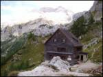 56
56 57
57 58
58 59
59 60
60 61
61 62
62 63
63 64
64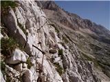 65
65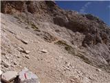 66
66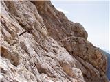 67
67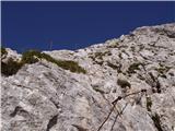 68
68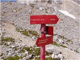 69
69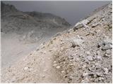 70
70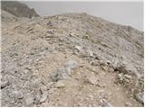 71
71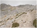 72
72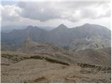 73
73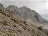 74
74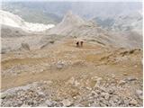 75
75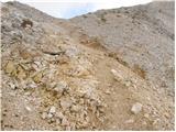 76
76 77
77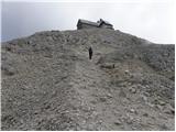 78
78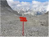 79
79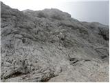 80
80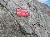 81
81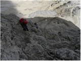 82
82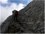 83
83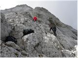 84
84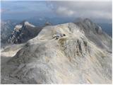 85
85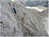 86
86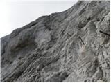 87
87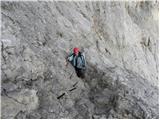 88
88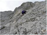 89
89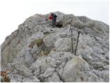 90
90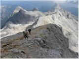 91
91 92
92 93
93 94
94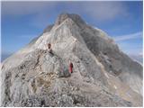 95
95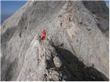 96
96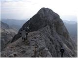 97
97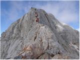 98
98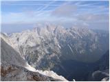 99
99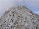 100
100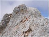 101
101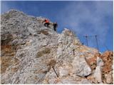 102
102 103
103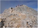 104
104 105
105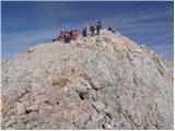 106
106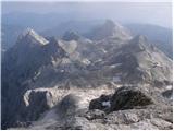 107
107 108
108
Discussion about the trip Konec ceste na Pokljuki - Triglav (via Kredarica)
|
| kmelans15. 08. 2014 |
Hi!
My husband and I are heading out for the first time on 13.9.2014 with the Lidl expedition and we're already fully excited.
Looking at the published photos is simply fantastic and I can hardly wait to go up there.
Kuštravček
|
|
|
|
| primmy9219. 07. 2015 |
On 19.7. a chain (engraving) with the name T. Dolinšek was lost on the path from Kredarica to Pokljuka. If anyone was lucky enough to find it, please contact me at 040148298. Thank you!
|
|
|
|
| mihab1013. 07. 2020 |
Hello, can someone please tell me if it is still possible to drive by car to the parking lot at the end of the road on Pokljuka? Thanks, I'm going on the trail on Wednesday.
lp
|
|
|
|
| enknap23. 08. 2020 |
On 22.08.2020 I lost my sunglasses somewhere on the path (most likely from Vodnik shelter down). If someone found them, please contact me at 030 696 002. Thanks.
|
|
|
|
| t_extreme18. 08. 2021 08:59:58 |
Hello,
I'm interested if anyone has recently walked this trail from Pokljuka - how much do they charge for parking space?
We're going for two days, and this info is quite important to me, especially if 24h parking is possible.
Thanks for any reply  . .
|
|
|
To post a comment you must log in:
If you do not yet have a username, you must first
register.