Konec ceste na Pokljuki - Triglavski dom na Kredarici
Starting point: Konec ceste na Pokljuki (1312 m)
| Latitude/Longitude: | 46,33860°N 13,90450°E |
| |
Walking time: 5 h
Difficulty: difficult marked way
Elevation gain: 1203 m
Elevation difference along the route: 1375 m
Map: Triglav 1:25.000
Recommended equipment (summer): helmet
Recommended equipment (winter): helmet, ice axe, crampons
Views: 25.647
 | 4 people like this post |
Access to starting point:a) Leave the Gorenjska motorway at the Lesce exit, then follow the signs for Bled and Pokljuka. Continue through Gorje and past the Zatrnik ski slope to Rudno polje on Pokljuka, where there is a large paid parking lot, and nearby a barracks and shooting range. From here continue straight on the gravel road, which a bit further leads to a junction, where continue right (left Uskovnica). Follow this road to the former Za Ribnico parking lot at the end of the road (nearby mountain signs for planina Konjščica).
Parking at the end of the road is now prohibited, so park at Rudno polje, extending the route by about 40 minutes; more appropriately, choose the marked trail starting at Rudno polje.
b) From Železniki or Podbrdo drive to Bohinjska Bistrica, then towards Bled. Shortly after the Petrol gas station just beyond Bohinjska Bistrica, turn left towards Pokljuka and Jereka. The road climbs steeply at first, then flattens gradually after Koriti, leading to a junction at the bus stop, continue right towards Pokljuka, Koprivnik and Jereka (straight Srednja vas). Right after the junction reach Jereka, from the church junction continue straight to Pokljuka (left Podjelje). After Jereka the road climbs steeply again, higher flattens along Mrzli potok. Joining the Bled road, go left to Rudno polje with large paid parking, nearby barracks and shooting range. From here straight on gravel road to junction, right (left Uskovnica), follow to former Za Ribnico parking (mountain signs for planina Konjščica).
Parking at end now prohibited, park at Rudno polje extending by 40 minutes; better marked trail from Rudno polje.
Traffic regime in Pokljuka and Uskovnica area from 15 June to 15 October.
Route description:
From the former parking lot at the end of the road, continue on the wide initially ascending cart track towards planina Konjščica. The track enters dense forest immediately, soon flattens, and after a few minutes of easy walking turns into a hiking path continuing along the left bank of the Ribnica stream. When the path approaches the stream closely, it turns slightly right and ascends more steeply. Higher, it flattens and leads out of the forest to the lower edge of the vast planina Konjščica. Here the path turns slightly left, crosses the streamlet, and after a few more steps reaches the cheese dairy on planina Konjščica.
From the dairy continue on the pleasant path which in a few minutes of gentle ascent brings to the upper edge of the pasture. Here the path enters the belt of dwarf pines and bushes and gradually starts ascending more steeply. In the upper part of the ascent towards Jezerce, the path from Rudno polje joins from the right; continue straight on the moderately steep path, which in a few more minutes brings to Jezerce, where it flattens and turns left (right branches the path to Srenjski preval).
Follows easy walking to the sign indicating the central area of TNP, then the path begins moderate ascent along the torrent, initially still a streamlet. Higher, the path crosses to the right side of the torrent (viewed from ascent direction) and then traverses up to Studorski preval, from which opens a nice view of the mountains above Bohinj.
Here a demanding path from Srenjski preval joins from the right, and from our path unmarked paths branch to Ablanca and Veliki Draški vrh.
From the saddle first descend steeply for a short time, then the path turns right, and we traverse the slopes to the left for a longer time with some short easy ascents and descents. From the slopes of Veliki Draški vrh we gradually reach the slopes of massive Tosc, continuing amid nice views past the branch to Tosc and junction where the path from Uskovnica joins from the left.
At all junctions, including where the partly abandoned path over planina Zgornji Tosc joins, continue straight; the path gradually leads to steeper and even precipitous southwest slopes of Tosc, where there was a landslide years ago, so extra caution is needed due to falling rocks. Over the precipitous part runs a fairly wide path, so no special difficulties; when the slope becomes less steep, the path from Stara Fužina or Voje valley joins from the left.
Continue straight on the wider marked path towards Triglav, heading north along the western slopes of Tosc; the still gentle path over some scree leads to Vodnikov dom at Velem polju, next junction.
Here too straight towards Triglav, the path starts traversing up the slopes of Vernar, higher becoming technically demanding. Follows some traversing aided by wire rope, higher reach a steep step where ascend rocky steps with numerous pegs and wire rope.
Ahead the path flattens, slope less steep and near Konjsko sedlo somewhat more grassy.
Easily descend to Konjsko sedlo, from marked junction at saddle head straight towards Triglavski dom na Kredarici and Staničev dom pod Triglavom (left Dom Planika pod Triglavom, right Krma valley), a few steps ahead path forks again.
Continue slightly left towards Kredarica (slightly right Dom Valentina Staniča) and traverse across numerous gullies, crossing them mostly not demanding. Further the path becomes technically harder, on some sections aids like wire ropes and pegs help safer progress.
At altitude just under 2300 m join the technically easier path from Krma valley, continue left towards Kredarica and Triglav.
A few minutes further when path flattens more, left branches path past Snežna konta and over Štapce to Dom Planika pod Triglavom, we continue right, first gently then ascend to the ridge above Vrh Snežne konte, the summit we saw from below during ascent over Kalvarija.
Here the path steepens again, follow it all the way to Triglavski dom na Kredarici.
Start - Planina Konjščica 0:30, Planina Konjščica - Klanci 0:40, Klanci - Jezerce 0:05, Jezerce - Studorski preval 0:30, Studorski preval - Planina Zgornji Tosc 0:35, Planina Zgornji Tosc - Na Zagonu 0:20, Na Zagonu - Vodnikov dom 0:20, Vodnikov dom - Konjsko sedlo 0:30, Konjsko sedlo - Kalvarija 0:55, Kalvarija - Triglavski dom 0:35.

Photos:
 1
1 2
2 3
3 4
4 5
5 6
6 7
7 8
8 9
9 10
10 11
11 12
12 13
13 14
14 15
15 16
16 17
17 18
18 19
19 20
20 21
21 22
22 23
23 24
24 25
25 26
26 27
27 28
28 29
29 30
30 31
31 32
32 33
33 34
34 35
35 36
36 37
37 38
38 39
39 40
40 41
41 42
42 43
43 44
44 45
45 46
46 47
47 48
48 49
49 50
50 51
51 52
52 53
53 54
54 55
55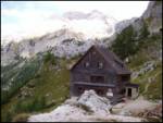 56
56 57
57 58
58 59
59 60
60 61
61 62
62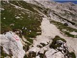 63
63 64
64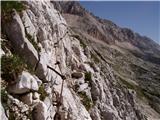 65
65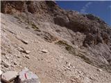 66
66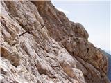 67
67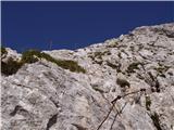 68
68 69
69 70
70 71
71 72
72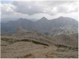 73
73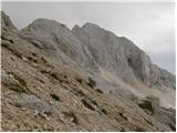 74
74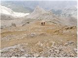 75
75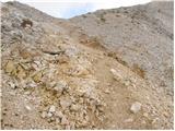 76
76 77
77
Discussion about the trip Konec ceste na Pokljuki - Triglavski dom na Kredarici
|
| _sandra_15. 11. 2012 |
Has anyone walked this path, how is the snow further from Konjsko sedlo towards Kredarica?
|
|
|
|
| zvezdica22216. 10. 2017 |
Yesterday we walked the upper path. For the first time I missed the timetable by a whole hour (usually I beat it), on the way back we really walked fast, at the end almost ran, with an intermediate break of not even half an hour, and we took 5.5 h to the car... The path is otherwise not demanding, a 9-year-old walked it in one day both directions without problems, he has quite a lot of stamina though and is used to more difficult sections.
|
|
|
To post a comment you must log in:
If you do not yet have a username, you must first
register.