Fuciade, Passo San Pellegrino - Sasso Vernale
Starting point: Fuciade, Passo San Pellegrino (1900 m)
Walking time: 5 h 30 min
Difficulty: partly demanding marked way, difficult unmarked way
Elevation gain: 1158 m
Elevation difference along the route: 1158 m
Map: Tabacco 1:25.000 (Marmolada)
Recommended equipment (summer): helmet
Recommended equipment (winter): helmet, ice axe, crampons
Views: 4.168
 | 1 person like this post |
Access to starting point:
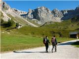
We leave the highway between Trieste and Venice at Portogruaro and follow the highway in the direction of Pordenone, Conegliano and Belluno, where we leave the highway and continue through Belluno, Ponte nelle Alpi, Agordo, Falcade, in the direction of Passo San Pellegrino. About a kilometer before we arrive at the pass, we turn at the signpost for Baita Flora Alpina right towards the grazing mountain pasture Malga Boer (1808 m) and the cirque Fuciade. After about a kilometer of steep road past the mountain pasture, we park on a marked parking lot by the bridge over Rio Cigole. The road continues to holiday cottages, cattle pen and mountain hut Fuciade, but a sign prohibits further driving.
It is also possible to approach on foot from the very pass past the hotel Miralago.
Another possible access is through Karawanks – Spittal – Lienz – Cortina d'Ampezzo – Falzarego – Alleghe – Falcade – Passo San Pellegrino.
Route description:
From the parking lot, we continue on a gentle, initially asphalted cart track over nice pastures in the direction of the wall above the valley Val Cigolè, above which reign the peaks Cima Uomo, Punta Cigolè, and Sasso di Valfredda, past idyllic cottages to the mountain hut/hotel Rifugio Fuciade, 1974 m (20 minutes).
At the junction for the hut, we leave the wide mule track and then over pastures follow path no. 607. Comfortable, even serpentines offer views of the distant Pale di San Martino and the nearby towers Cime Tascia and Torre Enrica. At the top of the grassy ridge, we enter extensive scree fields in Val Cirelle, over which runs a comfortable path with numerous switchbacks. At the signpost for Cima Uomo, the valley continues straight, but we turn sharply right and follow comfortable serpentines over the huge scree to the pass Cirelle (2683 m, from the hut 2.5 to 3 hours, cross/chapel).
At the pass, a view opens into the upper part of the valley Contrin and onto the elegant pyramid Sasso Vernale (3054 m), which reigns over the somewhat lower ridge Ombretta, behind which is the wide south face of Marmolada and to its left Gran Vernel. From the pass, easy half-hour trips are possible on unmarked but well-visible paths, to the left to the eastern peak of Cima Cadina (2885 m), to the right to Punta Cigolè (2815 m).
The path from the pass follows the markings for Rifugio Contrin for a few meters, then we continue along path 612 marked with red dots towards Rifugio Falier (sign on the rock). The path rises and falls several times on the slopes of Punta Cigolè and Cima Ombrettola. We cross some snow tongues that persist late into summer, and through crumbly, cluttered, almost lunar terrain in a steeper ascent reach the small ridge above Passo Ombrettola, 2864 m (1 hour from pass Cirelle), from which we look into the valley Vallon d'Ombrettola below the mighty walls proudly displayed by Sasso di Valfredda, Formenton, Monte la Banca, Fop, Civetta and Pelmo.
At the pass, the markings end. We descend a few meters towards the hut in the direction of Ombrettola, put on a helmet, leave the path below the lowest point of the saddle, and search for the path along the south ridge, which follows remnants of the military path from World War I. The relatively easy path with some exposed spots is littered with debris due to crumbly rock, so we carefully follow the most logical and obvious passages and remnants of military obstacles to the summit (cairn, 40 minutes - 1 hour from pass Ombrettola). The view in good weather is phenomenal. Return (3h) offers express delivery over just right soft scree from pass Cirelle almost to the starting point.

Along the route: Koča Rifugio Fuciade (1974m), Prelaz Passo Cirelle (2683m), vrh Cima Uomo (3011m), vrh Punta Cigole (2815m), vrh Cima dell Bachet (2800m), vrh Cima Cadina (2885m)
Photos:
 1
1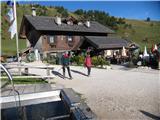 2
2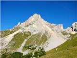 3
3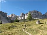 4
4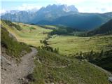 5
5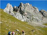 6
6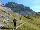 7
7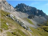 8
8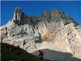 9
9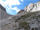 10
10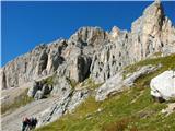 11
11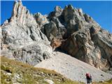 12
12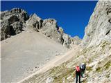 13
13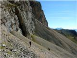 14
14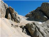 15
15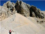 16
16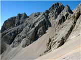 17
17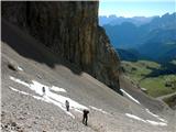 18
18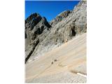 19
19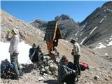 20
20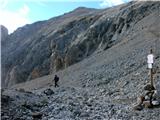 21
21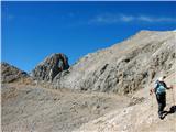 22
22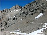 23
23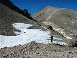 24
24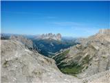 25
25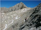 26
26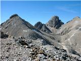 27
27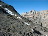 28
28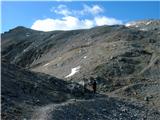 29
29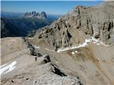 30
30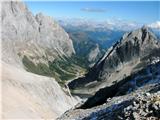 31
31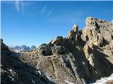 32
32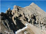 33
33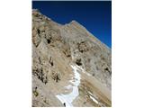 34
34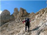 35
35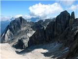 36
36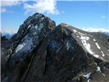 37
37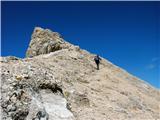 38
38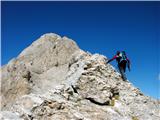 39
39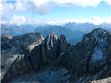 40
40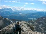 41
41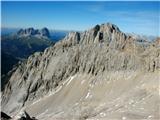 42
42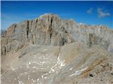 43
43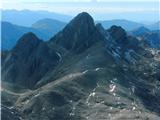 44
44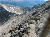 45
45 46
46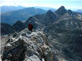 47
47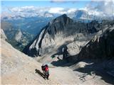 48
48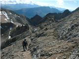 49
49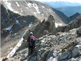 50
50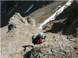 51
51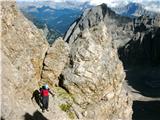 52
52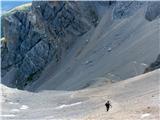 53
53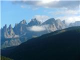 54
54
Discussion about the trip Fuciade, Passo San Pellegrino - Sasso Vernale
|
| Paglia28. 10. 2019 |
On Sunday, in probably the last exceptionally beautiful weekend, we did this tour as described above.
I'm quite an experienced mountaineer with many years of practice and therefore I give my subjective opinion on the description.
Up to the Ombrettola saddle, the description is very accurate, useful and correct.
From the saddle where the most demanding part awaits you, I absolutely cannot agree with the opinion that the path is very easy. There are no footholds as such, no safety gear of course, a very cautious step is needed all the way so as not to slip on the very steep and dangerous scree-covered rocky slope. The only aid are some metallic, slightly wobbly half-meter poles from the First World War, which are located only here and there in the middle part of the key ascent. For very experienced mountaineers accustomed to all kinds of difficulties, the ascent of course represents a big adrenaline bite.
We needed 5 hours for the ascent, 4 hours for the descent. The view was of course phenomenal on Sunday, when we can say it was a day for the gods, especially on the mighty south face of the nearby Marmolada.
Of course, if you're coming from central Slovenia (about 320 km one way), I recommend an overnight stay the day before in Falcade, where in the dead season we paid 60 eur for an apartment for 4 people together.
If anyone is interested in anything else, feel free to ask, I'll gladly answer.
|
|
|
|
| Pastirica28. 08. 2025 20:08:33 |
On Tuesday I stood on this beautiful but quite demanding three-thousander. I have to say I quite agree with the predecessor's rating. From the Ombrettola saddle onwards it was tricky. The entry itself (at least two variants) requires careful steps due to scree on the rocks. This is followed by an ascent up a fairly steep gully, where hands were very useful. The path continues to the right along a fairly safe track. Then comes that section with slabs and scree that requires all caution. The iron rods were helpful and at least those I used didn't wobble. Otherwise, I preferred to look for footholds and handholds in the rock itself. The very last part is easier again.
There were enough poles this time. I also had a GPS track and two hikers ahead of me, whom I watched from the saddle almost to the top.
For the whole path (from the bend towards Rifugio Flora Alpina - Passo Pellegrino) I needed 5.5 hours. From the Ombrettola saddle to the top 50 min and the same descent to the saddle.
If I compare the summit with the neighboring Ombretto Orientale, Vernale seemed harder to me. But I encountered similar terrain on the Tofane.
The view from the top is breathtaking. From the few well-known ones to the countless others. Stupendo (stunning)!
|
|
|
To post a comment you must log in:
If you do not yet have a username, you must first
register.