Gozd Martuljek - Škrlatica (ridge crossing Mali Oltar-Škrlatica)
Starting point: Gozd Martuljek (750 m)
| Latitude/Longitude: | 46,48210°N 13,83780°E |
| |
Route name: ridge crossing Mali Oltar-Škrlatica
Walking time: 14 h 30 min
Difficulty: rock climbing ascent
Elevation gain: 1990 m
Elevation difference along the route: 3800 m
Map: Kranjska Gora 1:30.000
Recommended equipment (summer): helmet
Recommended equipment (winter):
Views: 31.423
 | 9 people like this post |
Access to starting point:
From Mojstrana we drive towards Kranjska Gora or vice versa, but only to the village Gozd Martuljek, where we park on a parking lot near the bridge over the river Sava Dolinka (parking lot is located after the bridge, or before, if we come from Kranjska Gora).
Route description:
From Gozd Martuljek we ascend on a footpath which runs towards the cirque Za Akom. When we come on gravel terrain we continue right where also numerous cairns point us to. Further, when we walk on a wide riverbed of a torrent, we stick to the right side of the torrent. Here also nice views open up on the northern walls of Martuljek mountains, where Široka Peč stands out. Below Široka Peč we can already see first orientational point Pri treh macesnih. From gravel terrain, we then continue slightly left and for a short time ascend on a footpath through dwarf pines. The footpath brings us by a little steeper riverbed of a torrent, by which we are then ascending. The path here leads by the right side of the riverbed on an indistinct small ridge past rare larches upwards. Next follows crossing of a smaller stream and then ascent on the scree, which brings us on steeper rocky slopes. From here we continue slightly to the right and on smooth rocky plates on which there is quite a lot of sand we again cross the mentioned stream. The slope is here quite steep and because of sand on rocky plates quite some caution is needed. A short ascent follows on a very crumbly steep slope, which is also dangerous for slipping, and then the path brings us to the vantage point Pri treh macesnih.
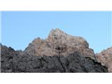
From here we continue on the partly grassy small ridge towards the south, where we see the characteristic boulder. Before the boulder we turn right, follows ascending towards the right below the scree of Oltar and Velika Martuljška Ponca. Below the foot of Oltar we ascend over a rocky band, and from there steep on the scree to the foot of the northern wall of Mali Oltar. Here starts route Bučer-Kristan, on which we will ascend to the summit of Mali Oltar.
By the fall-line of the groove, we look for easiest passage on a crumbly rocky slope, which then in easy climbing brings us to a red cave from which water always trickles. The route continues on a wall right from the cave. We climb one pitch to very exposed but easy traverse (IV-, 5m-piton), which leads into the second system of chimneys and it brings us on large cluttered ledge in the middle of the wall. We follow the ledge two pitches to the left (easy I-II.) and on an appropriate place we pass into the chimney, which cuts the entire northern wall of Mali Oltar. Chimney (dolomite rock - best rock in Martuljek) in three pitches (II-III. grade) soon leads right out from it into the last wall, which we climb on exposed plates and outside corner (anchor in the wall with two pitons), this is also the most difficult part of the route Bučer-Kristan (IV-, one pitch). With an ascent to the summit of Mali Oltar we continue on easy dihedral (II-III.) on the left side of the outside corner or straight on plates (IV-). To here we needed from the starting point 6 hours.
Here our tour in fact just starts for real. From the top of Mali Oltar we need to descend into a notch between Mali Oltar and eastern column of Oltar ridge (anchor for a descent is settled) and from there straight two pitches on the east column to the top of unnamed Oltar. On the top, there is an anchor for a descent (check the piton, because this ridge is very little visited), which takes us from great compact rock into completely broken and unclear terrain. Here the climbing is very exposed and dangerous! In "crumbly" climbing we are getting closer also towards the last descent on a rope before we reach the peak of Veliki Oltar. This descent brings us into a very broken but easy notch, which with the help of chimney leads exactly to the summit of Veliki Oltar. From Mali Oltar to the top of Veliki Oltar we needed two hours.
From there ridge goes in all its glory towards our destination Škrlatica.
We continue on the ridge and on an appropriate place we descend on system of ledges and crumbly traverses in the eastern flank of the ridge. The system of ledges soon brings us into a notch between Veliki Oltar and Visoki Rokav. We leave the notch on an exposed wall and we cross into the western flank of the ridge, which through two gullies and system of ledges brings us to plate (III. grade 10 meters) on which we reach a sharp ridge. To the peak of Visoki Rokav we have only easy climbing on broken ridge. From the top of Veliki Oltar to here we needed approximately two hours. The difficulty didn't exceed anywhere III. grade on UIAA.
From the top of Visoki Rokav ridge at first continues towards the south, but soon turns towards the west. With the help of a settled anchor, we descend 25 meters to the beginning of the ridge Žaga, which separates us from Škrlatica. First sharp towers, which climbing pioneers named Financarji, it is possible to climb around on the left side, and further it is best to climb on the sharp ridge. For the route on the ridge, there isn't any most recommended line - each roped party chooses the path themselves, according to their capabilities. The difficulty of certain spots shouldn't exceed IV. grade, but if we go astray from the ideal line it quickly gets close to V. grade on UIAA.
In vertiginous slalom, we are getting closer to the last barrier, which separates us from the upper massif of Škrlatica. Survey point of the ridge, which has a status of an independent peak is by far most difficult tower, because climbing on the sharp and exposed peak in final overhang easily reaches fourth grade. From the top of the tower with the help of two descents on a rope we descend into the last notch.
From the notch between Rokav ridge and Škrlatica we ascend on exposed but surprisingly easy (II-III.) wall to the summit of Škrlatica, which we reach left from the cross. From the peak Visoki Rokav to here we needed 5 hours! Next follows only a descent into Vrata, which lasts at least 3 hours.
To all who will repeat the tour, I strongly recommend excellent psychophysical fitness, enough water and experience in climbing in such terrain. The terrain is in parts completely broken and crumbly, sharp and unclear. I recommend being escorted by someone, who already was there, complete climbing equipment with at least five pitons. The tour is very long and mentally strenuous. On key spots belaying is recommended. The technical difficulty of the tour is around IV on UIAA, dangers such as falling stones, bad weather and other factors are not included in the difficulty of climbing. In bad weather do not do the tour. There isn't any water on the ridge! Early exit is possible from Veliki Oltar and Visoki Rokav. I recommend 60 meters rope.
Because of the length and complexity of the tour I recommend a company of a mountain guide or alpinist.
Climbing of this ridge will present this area in a completely new light. On the tour go only in stable weather. Ridge Mali Oltar - Veliki Oltar belongs among very dangerous and difficult.
Climbing knowledge is mandatory and master the climbing in a roped party. In case we belay all pitches of the crossing, a bivouac is inevitable.

Photos:
 1
1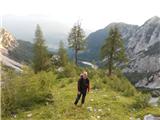 2
2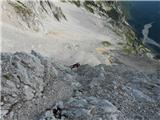 3
3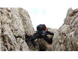 4
4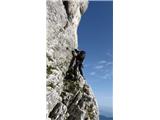 5
5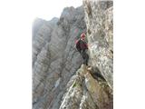 6
6 7
7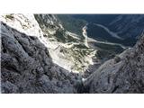 8
8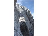 9
9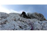 10
10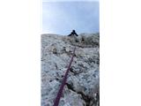 11
11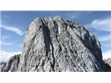 12
12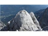 13
13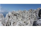 14
14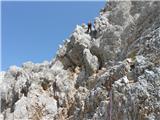 15
15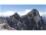 16
16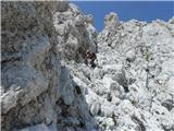 17
17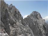 18
18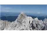 19
19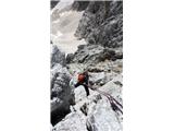 20
20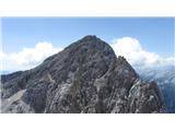 21
21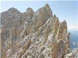 22
22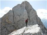 23
23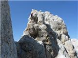 24
24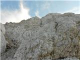 25
25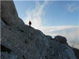 26
26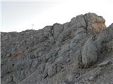 27
27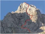 28
28
Discussion about the trip Gozd Martuljek - Škrlatica (ridge crossing Mali Oltar-Škrlatica)
|
| dprapr5. 02. 2014 |
This must be a real grande tour if you manage it to that extent. The timetable says it all!
Us "old guys" will have to do it in two parts.
I'm missing the second part.
|
|
|
|
| JusAvgustin5. 02. 2014 |
I had mixed feelings describing the tour, since I didn't know how it would be received. Definitely a ridge highlight on one of the most "crazy" ridge climbs around here! Descent not included in the timetable!
Regards
|
|
|
|
| Janez Seliškar5. 02. 2014 |
Hats off to everyone who can manage this, technically, physically and mentally.
|
|
|
|
| jlapanja5. 02. 2014 |
I'd really like to do such a tour, unfortunately I got addicted to mountains too late.
|
|
|
|
| skrajnik5. 02. 2014 |
this one is a bit tough for hribi.net, right?
thanks anyway, I'll go
|
|
|
|
| mukica6. 02. 2014 |
woooow, a dream, at least for me  Sincere congratulations for the magnificent tour Sincere congratulations for the magnificent tour
|
|
|
|
| bosketi3. 06. 2014 |
Hats off for this tour!!! Probably not many repeats, or perhaps?
|
|
|
|
| JusAvgustin3. 06. 2014 |
This year I'm going again In a slightly longer version.
|
|
|
|
| kremenckov ata3. 06. 2014 |
On the Oltar ridge there's blowdown like on a wide stove. After the clearing you descend to the amphitheater, but from there you can't directly escape to the valley.
|
|
|
|
| JusAvgustin4. 06. 2014 |
No need to mess with the description, especially not with such ignorance as you just wrote, where not one claim holds. No hard feelings, but on this point I'm sensitive.
|
|
|
To post a comment you must log in:
If you do not yet have a username, you must first
register.