Gozd Martuljek - Široka peč
Starting point: Gozd Martuljek (750 m)
| Latitude/Longitude: | 46,48210°N 13,83780°E |
| |
Walking time: 5 h
Difficulty: rock climbing ascent
Elevation gain: 1747 m
Elevation difference along the route: 1750 m
Map: Kranjska Gora 1:30.000
Recommended equipment (summer): helmet, lamp
Recommended equipment (winter): helmet, ice axe, crampons, lamp
Views: 29.344
 | 8 people like this post |
Access to starting point:
From Mojstrana we drive towards Kranjska Gora or vice versa, but only to the village Gozd Martuljek, where we park on a parking lot near the bridge over the river Sava Dolinka (parking lot is located after the bridge, or before, if we come from Kranjska Gora).
Route description:
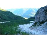
From the parking lot, we continue by the main road towards Kranjska Gora, but only to a spot, where cycling road branches off to the left (by the beginning of the cycling path there are also signposts, which point us on the mentioned road). We follow the cycling road to the first crossroad, where we continue straight on a macadam road (cycling road turns right), which quickly brings us to the next crossroad.
We continue to the right and follow the road closed to traffic up to the TNP signpost. Further, the path splits into two parts. We continue straight upwards on a steep cart track which is ascending on the right side of gorge Martuljška soteska. Cart track, which is mostly ascending through the forest after 15 minutes brings us on a nice vantage point, where a view opens up towards a valley. The path then goes again in the forest and continues to ascend. A little further from the left joins the path from the waterfall, and a little further, the path towards the bivouac Bivak pod Špikom branches off to the right. We continue in the direction of the cottage Ingotova koča. The path ahead brings us to a crossing, where we continue straight, the path left runs to the cottage Ingotova koča to which is two minutes of walking.
The path ahead at first ascends gently, but only for a short while. After that, the path crosses a spring and on the other side steeply ascends. Steepness starts decreasing and the path brings us to a crossing, where we continue slightly right in the direction of bivouac Za Akom (left waterfall Zgornji slap 10 minutes). The path ahead is for some time still steeply ascending, and then the path brings us to a more demanding part. First, with the help of steel cables we cross steep grassy slope, and then still with the help of fixed safety gear we walk over an exposed ledge (watch your head, slightly overhanging rock above us). Still secured path (fixed safety gear are here mainly because of wet terrain), then starts ascending steeper and after few minutes of additional walking brings us to the most difficult part. With the help of artificial steps and steel cables, we cross a smooth and wet rocky plate, and then we also cross a shorter very steep wall, which is also well-secured (because of wet slopes a great caution is needed). The steepness of the slopes then decreases and still wet path after a shorter ascent brings us by the edge of mighty gravel beds. We are at the juncture of two gullies, we continue on the left, in front of us a view starts opening up on mighty upper massif of Široka peč. At the end the gully splits into more parts, we continue on the right gully, to first smooth jammed boulder (8 meters III.), which we climb on the left (if left side is wet, we have no other choice, than that we climb it on the middle, which increases difficulty!), we are ascending upwards through the gully, cairns showing the way. We are already in front of a smooth jump (15 meters II.), which we start climbing on the left (ramp, piton for belaying), to a smaller plain. Now follows climbing on broken, crumbly terrain (15 meters, II.) to green shoulder, where we can relax for a moment.
We continue straight towards the V pillar of Široka peč, to a rock barrier. We avoid rock barrier to the right, few more meters separates us to the first key point of the ascent. We are in front of 30 meters rocky jump, which is closing passage into amphitheater. Jump is divided into two parts, first part is easy and we can climb it without belaying, and in the second part belaying is mandatory (III+), there are enough pitons, the anchor is also settled. From the anchor, we go forward towards easier rock bands, which we bypass from the right towards the left (50 meters I.) and now we are in the amphitheatre. We continue towards the gable of the cirque, to a well visible ramp (100 meters I.-II.) in the massif of Široka peč. On the ramp, we ascend to the notch, in which we then descend on a rope (anchors are equipped, descent into a notch as well). From the notch, we continue on reddish gully (crumbly, slippery), to the ridge. A meter before the ridge we turn right and we cross smooth plate (I.) to the next small notch. Follows second key spot: traverse to the right, on an exposed ledge (I.-II.) (for detour we can descend from a small notch into the gully and we continue on the ridge, but the gully is steep and unpleasant). Now we have only a pitch of climbing on a crumbly and broken terrain to the main peak of Široka peč.
The ascent from Gozd Martuljek to Široko peč is considered an alpine climb; set out on this route with someone who has already been to the summit, most suitably with a mountain guide.
Široka peč is well equipped.

Photos:
 1
1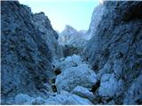 2
2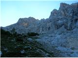 3
3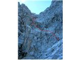 4
4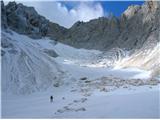 5
5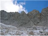 6
6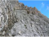 7
7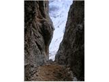 8
8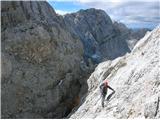 9
9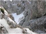 10
10 11
11 12
12 13
13
Discussion about the trip Gozd Martuljek - Široka peč
|
| JusAvgustin21. 10. 2010 |
regarding the difficulty, that there is no data is not true. it's a very demanding pathless route, alpinistic ascent. from Gozd Martuljek it's harder than from the Dovški križ direction, the latter is II-III (ridge crossing to the main tower), from GM due to the jump before entering the amphitheater II-III+ (30m). I strongly recommend the tour to lovers of pathless routes and scrambling, as this mighty mountain has almost no visitors. as a curiosity: since 1998, when the summit logbook was placed there, my colleague and I signed as 243rd and 244th. Maybe a small comment on the tour regarding equipment: I recommend double rope 2x60m as the abseils are longer and you need to abseil less often. but there's more work with the rope... everyone should judge for themselves. anyway, whoever stands on the summit should look around because the wilderness is indescribable. I wish you a safe ascent.
|
|
|
|
| dprapr11. 08. 2014 |
That it's easier with DK somehow doesn't fit together. Towards ŠP yes, because we can descend to the notch above the gully with a rope, but back? Unless we return back via the amphitheater and up to DK via the crumbly gully?
Juš, now it's sequential no. 273.
|
|
|
|
| lijaneja11. 08. 2014 |
It's an honor that one of the last three numbers is mine.
|
|
|
|
| dprapr1. 09. 2014 |
Correction to my above note: the sequential final number on our visit was 373. Thus the average annual visit is higher than I noted somewhere, approx. 23 not 17.
That I reduced the number by 100 I noticed after seeing the photos of the predecessors' logbook.
|
|
|
|
| ljubitelj gora1. 09. 2014 |
The number of logbook entries doesn't always match the number of visits. Plenty don't sign in
|
|
|
|
| JusAvgustin1. 09. 2014 |
especially you who's been up there so many times, right?
|
|
|
|
| dprapr1. 09. 2014 |
Matej, quite probably not, but here and there someone does!
|
|
|
|
| bosketi29. 10. 2014 |
For us with Mountain Lover this is a stroll..that signature has no meaning.
|
|
|
|
| katja8725. 09. 2015 |
On Tuesday we seized the last nice day before the snowfall and headed to this wonderful mountain, long a great wish. The weather favoured us, conditions too, the rock already quite cold, fitting for the season  Views for the gods Views for the gods
The tour is truly demanding and for the ascent you need plenty of experience, good fitness, and knowledge of climbing and rope techniques.
We are very proud to have signed the summit book as No. 424 and 425
More photos and route description on the website of Planinsko društvo Matica Murska Sobota: http://www.pdmaticams-drustvo.si/ (see: Album slik!)
|
|
|
|
| andrejp11. 11. 2015 |
426 and 427....insanely good
|
|
|
|
| andrejp12. 11. 2015 |
for yesterday I just wanted to add that we climbed the first boulder that is an obstacle on the right side, which is much easier than the left side, which is wet and slippery
A and J
|
|
|
|
| dprapr12. 11. 2015 |
What about the photos? Why should only you two enjoy them...
|
|
|
|
| andrejp12. 11. 2015 |
I have them on FB, can't post them here unless you open a topic on conditions
|
|
|
|
| andrejp19. 06. 2017 |
Yesterday to Široka peč through the amphitheater and along the ridge to Dovški križ. Snow is no obstacle anywhere, fixed protection is ok. We then descended from sedlo Grlo (2x30m ropes), past Treh macesnov to the starting point. From the saddle to the anchor for the 1st rappel there is still snow and you need winter gear.
|
|
|
|
| ljubitelj gora19. 06. 2017 |
I saw you, took pictures, we were at Škrnatarica
|
|
|
|
| Dr.ejči7. 08. 2017 |
5.8., probably the most crowded day trip visit?...registered 470, 471, 472, 473, 474, 475, 476...good, really good!!!!
|
|
|
|
| dprapr7. 08. 2017 |
16.7.08 there were at least eight of them.
|
|
|
|
| Dr.ejči7. 08. 2017 |
Ufff...I really didn't search that far back...then the second?
|
|
|
|
| dprapr7. 08. 2017 |
There were six of us, and two more were coming along the ridge to the top. Maybe someone else that day...
|
|
|
|
| dprapr5. 10. 2017 |
Interesting, you drink Laško and climb Široka peč. Pure-blooded Slovenes.
|
|
|
|
| Shkaro5. 10. 2017 |
Hahaha, thanks
|
|
|
|
| Marecar4. 08. 2019 |
Today from Dovški križ to Široka peč. Demanding mountain. This mountain requires a bit of a climber. Without a rope it wouldn't go. Signed 539. And colleagues 537 and 538, without whom this feat wouldn't have succeeded for me, because I didn't have a rope. They had already gone several times and kindly invited me along. Very satisfied ... But when you climb this, you realize that mountains like Škrlatica, Veliki Oltar, Vrh nad Mužici, Mrzla gora, Razor, Jalovec, Mangart and similar are not even remotely as demanding ..., only the lower, middle and Visoki Rokav are quite a challenge.
Best regards to all mountain lovers ...
|
|
|
|
| Grega9228. 06. 2020 |
On Wednesday 24.6 to Široka peč from GM. Approach gully still fully snow-covered, so progress is quick. Snowfield still below the hardest part, jump into Amphitheater, and approach to the ledge at end of cirque, elsewhere no issues, useful for descent. Signed at top under numbers 559 and 560. Descent anchors arranged, on some replaced or added new prusiks.
Tour truly worthy of respect, ascent requires mileage, good fitness and climbing/rope skills.
best
|
|
|
|
| Heavy_bull21. 06. 2022 10:52:21 |
Yesterday (20.6.) to Široka peč from Gozd Martuljek. First boulder - stream on the left side, so on the right side (auxiliary rope installed here on the way back). After the first boulder before the wet rock barrier left over the "rickety" snow bridge - ice axe recommended. Snow still on some smaller sections, no problems, but ice axe might still come in handy. For descent into the notch along the entry traverse / ledge from the cirque a rope is installed. Great weather and excellent conditions. Photos added to Široka peč 2497 m a.s.l. - Forum.
|
|
|
|
| Kostja Jerovšek31. 08. 2022 15:13:32 |
(25.8.) to Široka peč via Skok and through Amfiteater. Above Skok in the box replaced the logbook. Since it was too big I sawed it in half. There is more snow in Amfiteater than three years ago at this time, but with a deep hole. On the last abseil in the gully added a sling, the next one should hammer the second peg... if he has a hammer with him.
|
|
|
To post a comment you must log in:
If you do not yet have a username, you must first
register.