Gozdec - Dom Petra Skalarja na Kaninu
Starting point: Gozdec (1075 m)
| Latitude/Longitude: | 46,33850°N 13,49390°E |
| |
Walking time: 4 h 15 min
Difficulty: easy marked way
Elevation gain: 1185 m
Elevation difference along the route: 1250 m
Map: Julijske Alpe - zahodni del 1:50.000
Recommended equipment (summer): helmet
Recommended equipment (winter): helmet, ice axe, crampons
Views: 24.707
 | 2 people like this post |
Access to starting point:
We drive to the center of Bovec, where from the intersection at the main square we continue along the ascending road that begins to climb past the post office towards the nearby church. We bypass the mentioned church on the left side, then arrive in Kaninska vas. Bovec then ends, and the road leads us westwards for a while longer. At a smaller junction, we leave the main asphalt road leading to the village of Plužna and continue driving along the slightly right road (after the intersection, signs for Gozdec road). Beyond the nearby farmhouse, the road forks again, and this time we choose the slightly left road (slightly right Zavrzelno and the trailhead for Rombon). We then ascend along the gravel road, which higher up brings us to the B station of the Kanin cable car. At the B station, the road turns sharply left, then after approximately 1 km of further driving in a transverse ascent, it brings us to the next intersection. From this intersection, we continue left or straight ahead (sharply right to planina Krnica), following the road from the intersection only briefly. Soon along the road we notice signs for Kanin, and we park about 20 meters further on, at a small parking area by the road.
From Trga Golobarskih žrtev to the starting point is approximately 9 km.
Route description:
From the starting point, we go back a few steps, then head onto the marked trail in the direction of Visoki Kanin and Vrh Laške planje. The trail immediately starts to ascend steeply, mostly leading us through dense forest, with only occasional views of the surroundings. During the ascent, the trail takes us below the cliffs of Turn v Skednju (1555 m). When the cliffs end, we reach an unmarked junction, where we continue slightly right on the marked trail (slightly left unmarked trail leading to Veliki Babanski Skedenj 2121 m); this soon steeply climbs over a short steep slope, where there is a greater risk of slipping especially when wet. The steepness soon eases, and we arrive at the abandoned Planina Gozdec, which we bypass on the right side.
We then ascend through increasingly sparse forest, so that we get some views from the trail towards the Bovec Basin and the Krn Mountains. A fairly even ascent follows, and while looking at the walls of Veliki Skedenj, we reach a small spring located to the right of the trail. Even further on, the easy-to-follow trail is covered with grass that can be quite wet after rain, in the morning, and in the forenoon. After a while, the trail turns more towards the west and gradually becomes less steep. A few more minutes of scenic ascent follow, and we reach the ruins of the old Peter Skalar hut, which burned down in 1972.
We bypass the hut on the left side, then ascend gently to moderately for a while through more grassy terrain. The trail then turns more southwards, giving the feeling that we are going in the wrong direction. A somewhat steeper ascent follows, but the trail slowly turns right, so that afterwards we mostly walk westwards. A few more minutes of easy walking follow, and we reach a marked junction, where we continue right downwards in the direction of Dom Petra Skalarja na Kaninu (straight to Visoki Kanin and Vrh Laške planje).
After a short descent, the trail levels out, then crosses the flat areas. An ascent follows through the high mountain landscape of the Kanin Plains, where there is mostly no path, but the markers are fairly frequent, so orientation in good weather is not a problem, though it is entirely different in fog. The trail further leads over scree and among screes, pits, and cracks, so caution is advised, and in wet conditions the smooth slabs can be quite slippery. We then traverse upwards along the slopes of Velika Gnila glava (2114 m) for a while, and the trail brings us to the next marked junction on this section.
We continue slightly right (left returns to the trail towards Vrh Laške planje) and carefully follow the faint path and markers further on. We follow this trail, which offers truly beautiful views of the Kanin massif, all the way to Dom Petra Skalarja na Kaninu, from where we get an even better view to the east.
Gozdec - Planina Gozdec 0:45, Planina Gozdec - Stara koča 1:25, Stara koča - Mali dol 0:30, Mali Dol - razpotje pod Gnilo glavo 0:40, razpotje pod Gnilo glavo - Dom Petra Skalarja 0:55.
Description and photos refer to the conditions in 2019 (July).

Photos:
 1
1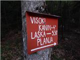 2
2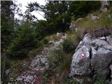 3
3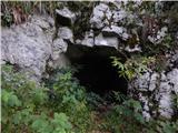 4
4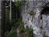 5
5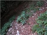 6
6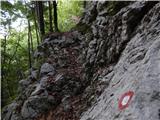 7
7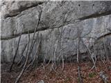 8
8 9
9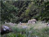 10
10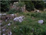 11
11 12
12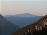 13
13 14
14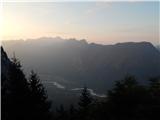 15
15 16
16 17
17 18
18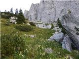 19
19 20
20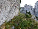 21
21 22
22 23
23 24
24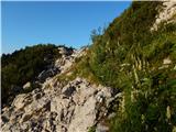 25
25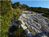 26
26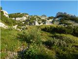 27
27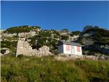 28
28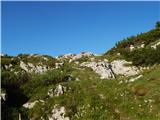 29
29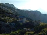 30
30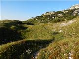 31
31 32
32 33
33 34
34 35
35 36
36 37
37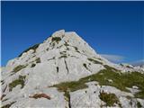 38
38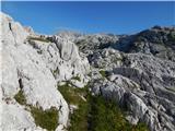 39
39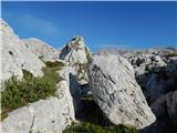 40
40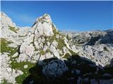 41
41 42
42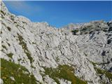 43
43 44
44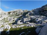 45
45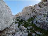 46
46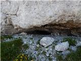 47
47 48
48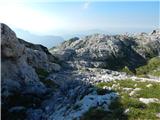 49
49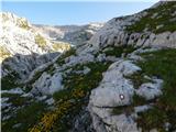 50
50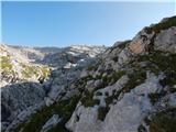 51
51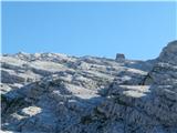 52
52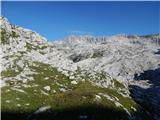 53
53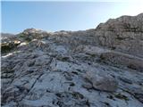 54
54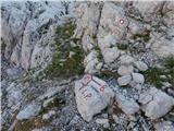 55
55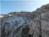 56
56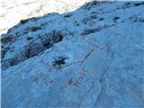 57
57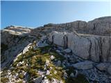 58
58 59
59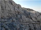 60
60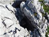 61
61 62
62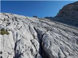 63
63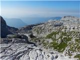 64
64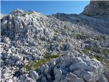 65
65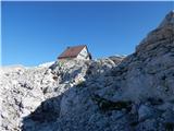 66
66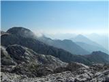 67
67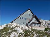 68
68
Discussion about the trip Gozdec - Dom Petra Skalarja na Kaninu
|
| milanl5. 07. 2010 |
Poorly marked trail, especially at the beginning, when you have to steeply branch off to the right and not take the left path after approx. 30 minutes of ascent. The marks along the trail are intended for Kanin and you have to follow them to reach Petra Skalarja correctly.
I suggest renewing the marks and already at the beginning at the parking lot a sign for the ascent to Dom Petra Skalarja.
|
|
|
|
| IgorZlodej5. 07. 2010 |
Good suggestion, only the former PZS president is to blame that some of us have lost the will to work on trails.
|
|
|
|
| joža x5. 07. 2010 |
Suggestion: if the marks have faded or are invisible in places, someone could put up a sign "unmarked trail" at the starting point. On the paper map, namely, the marks don't fade, you arrive at the starting point, you've already driven e.g. 250 km, and then you try despite the poor marks, what can happen afterwards is already part of the black.....
|
|
|
|
| IgorZlodej5. 07. 2010 |
In Gozdec at the starting point there is a signpost. I dare count on the fingers of one hand all those who from there go to Visoki Kanin or to Dom PS, significantly more of them go for example to Babanjski skedenj to which no marked path leads and no one has gotten lost yet. If you don't believe it, go to the top of this beautiful viewpoint above the Kanin slopes and you will see how many entries there are. The problem of our hikers is that they do almost nothing in preparing the tour, they do not familiarize themselves with the paths and descriptions, they do not have mountaineering maps, then they complain because the markings are not such that they are right in front of their eyes. Otherwise, you can complain to the association responsible for maintaining this path or to KPP at PZS. Someone had an interest that paths would no longer be maintained in the Bovec area and I can only congratulate him for fully succeeding.
|
|
|
|
| turbo5. 07. 2010 |
The best is to hike "by nose". Not only in the Kanin mountain range. Just like that, in general. There is usually no crowd, experiences are deep, you approach many peaks that many haven't even heard of and more and more.
Despite poor markings, it's still worth trying. This certainly isn't part of the black chronicle. Because markings fade, that's true, but the trodden path, trail, remains. Plus a map with you and it must go. Definitely in good weather, in fog those markings don't help anyway.
Otherwise, no offense, the best markings in the mountains are common sense and experience. If you think it won't work, it certainly won't. If you already... I wouldn't rely on luck.
|
|
|
|
| Gorazd G5. 07. 2010 |
Both predecessors wrote excellently and, at least in my opinion, hit the essence. 
|
|
|
|
| roba30001. 07. 2015 |
Any new information about this trail? Maybe renewed markings?
|
|
|
|
| mlakar191. 07. 2015 |
the path is the same almost no markings hut closed
|
|
|
|
| IgorZlodej1. 07. 2015 |
This year markings from the road to the path start to the spring were renewed, that's a bit below the ruins of the old hut. The path was also nicely sawn and cleaned. As far as I know, all markings to Visoki Kanin will be renewed during the summer.
|
|
|
|
| BT882. 07. 2015 |
Since Igor might read this and probably pick some around there, here's how blueberries look there under špičko  for info, I'll repay as per the informer's wish for info, I'll repay as per the informer's wish
|
|
|
|
| papillon3. 07. 2017 |
Does anyone know if the markings are now fully restored or not?
|
|
|
|
| mirank3. 07. 2017 |
Yesterday we joined this route about 15 min above the ruins of the old hut. From there down they were completely fine; upwards from there I can't guarantee, but the hut is visible and the terrain clear, so no panic, as long as you're not completely dependent on them.
Steady step and good luck
|
|
|
|
| papillon12. 07. 2017 |
Great, many thanks for the reply.
|
|
|
|
| nikilito13. 09. 2018 |
Hi everyone!
I'm writing to know if someone followed this path through Godzec and if there are visible marks on the track until Dom Petra Skalarja.
Can you also help me with the right direction?
I understood the path until the 4th photo. And then? I guess that I must turn right somewhere ..
Thank you very much.
|
|
|
|
| djimuzl13. 09. 2018 |
Quick translation off the path description:
From the parking lot we focus on the footpath in the direction of Kanin and Laška Planja. The path starts in the forest with a moderate ascent. After half an hour we reach the abandoned mountain pasture planina Gozdec (1305m). Later the path gets steepeer. We walk under the walls of the Veliki Skedenj.
At a height of 1814 m, we pass the ruins of the old Kanin lodge (Krlišče), where the path turns left, it descends slightly, and then in a slight ascent, it leads to a crossroads. There we continue to the right in the direction of Petar Skalar's lodge (straight Visoki Kanin).
Path now leads us through Kaninski podi – which is tipical high-lying plateau or karst area. It is well marked, but especially in the low visibility (fog) very hard to follow, and leads us in a moderate climb through labyrinth of the abysses, scrapes and cracks to the Peter Skalar's mountain lodge (Dom Petra Skalarja). Difficult orienting!
The lodge is not open but the nearby winter room usually is.
|
|
|
|
| zvezdica_zaspanka22. 07. 2019 |
Hi,
sometime before the end of summer I'm heading up there, just wondering what the path is like now - any trouble finding the markers or easy to follow? Usually equipped with map and compass, but prefer not to stray off path if not necessary
|
|
|
|
| Tadej25. 07. 2019 |
Yesterday I was on this trail. The markings have been renewed, and the upper description has also been updated.
|
|
|
|
| LukaSLO30. 07. 2019 |
What's happening with Dom Petra Skalarja on Kanin? Is it already open?
Somewhere I read that they've been renovating it for two years already...
|
|
|
|
| mirank30. 06. 2022 16:48:41 |
The condition at the hut is the same as before - like after the flood. The difference is the dixi bivouac, whose parts, piled up, have turned into a bivouac for vermin.
|
|
|
|
| darinka45. 08. 2022 15:47:21 |
Yesterday we descended from Visoki Kanin to Koča Petra Skalarja. The bivouac is unfortunately demolished. The windows are still piled up waiting for transport to the valley. The path is marked. The cairns are quite visible and at least we had no problems. We chatted with the cavers at the hut who are trying to renovate it. I imagined a smaller hut. But since it was my first time there I was surprised. Also in the continuation of the walk past the burned hut and GRS shelter there were no problems with following. They are also renovating there, or perhaps they will rebuild the hut. The path to the valley to Gozdec is cleared. Grass mowed. In good weather no problems with following. Just need to be well prepared fitness-wise.
|
|
|
To post a comment you must log in:
If you do not yet have a username, you must first
register.