Gradišče pri Vipavi - Gradiška Tura (Otmar route)
Starting point: Gradišče pri Vipavi (250 m)
| Latitude/Longitude: | 45,83230°N 13,97100°E |
| |
Route name: Otmar route
Walking time: 1 h 40 min
Difficulty: very difficult marked way
Via ferrata: C
Elevation gain: 504 m
Elevation difference along the route: 515 m
Map: Nanos 1:50.000
Recommended equipment (summer): helmet, self belay set
Recommended equipment (winter): helmet, self belay set
Views: 67.640
 | 5 people like this post |
Access to starting point:
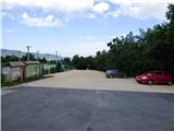
From Razdrto we drive along the highway towards Nova Gorica or vice versa and take the Vipava exit. We continue along the road towards Vipava and Gradišče. In the village of Gradišče we notice the first mountain signs, which we follow to the larger parking lot by Camp Tura above the village of Gradišče.
Route description:
From the parking lot, bypassing the information boards, we head in the direction of Gradiška Tura and Abram. At first, a relatively wide path leads us through the forest and soon brings us to a junction on a small clearing. Here the path to St. Nicholas branches off to the right, while we continue left towards Gradiška Tura.
From the junction the path quickly leads us to a scree slope and then turns right. We continue along the marked path and keep following the signs for Gradiška Tura. Along the way we will also notice boards indicating climbing routes. The path then begins to ascend somewhat more steeply and occasionally beautiful views of the Vipava Valley open up. The path, which here runs along shrubs and through low forest, brings us to the next marked junction where the Furlanova path to Gradiška Tura branches off to the left.
We continue right, where the signs for Gradiška Tura along the Otmar route direct us. The path then runs along a somewhat steeper slope where some protection also helps us. Along such a path we then reach the scenic Oltar.
From Oltar we continue along the steep path, which is in places protected by a cable or pitons, and soon we are again at a junction. This time the usual easier path to Gradiška Tura branches off to the left, while we turn right towards the Otmar route. After a short traverse the path then brings us under the wall where the start of the secured climbing route is.
Before entering the climbing section of the path we equip ourselves with a helmet and a self-belaying set. The use of climbing gloves is also recommended. On the initial section, which is the most difficult part of the path, we first ascend steeply on numerous stemples steeply upwards. The path then turns left and follows a very exposed traverse of the wall where numerous stemples still help us. After the traverse the path turns right upwards and also ascends over a short overhang (difficulty up to C).
Above the overhang follows a slightly less demanding ascent on stemples, which brings us to a ledge by a tree. Above the tree we then ascend along a still relatively steep but well-dissected slope where, in addition to the cable, we are occasionally helped by some stemples or steps carved into the rock. The path here runs somewhat to the right, later turns left upwards and brings us to gentler terrain where the secured path ends for a short time. Here a transverse trail from the top of the Furlanova path also joins from the left.
We continue along the scenic trail, which quickly brings us back to cables. First we ascend along the cable over dissected rock and then another ascent on stemples follows, with the help of which we also climb over a very short overhang. The path then turns right and follows a somewhat exposed traverse, which brings us to the next stemples. With the help of numerous stemples we ascend the wall upwards. We continue again somewhat to the right and the path brings us to somewhat less steep and more vegetated terrain. Here we then ascend for quite some time along the cable on a slightly less demanding slope and a little higher the secured path ends again for a short time.
We continue right along the trail, which past a memorial plaque brings us to the last section of the secured path.
Here we again ascend steeply with the help of stemples and then continue ascending quite steeply for some time along a wide ridge. In the final section there is still an ascent over a short chimney and then the secured path ends.
At the end of the secured path, where an easier path also joins from the left, we continue straight and after approximately 10 minutes of ascent reach the scenic summit.
The described path is categorized as a very difficult mountain path; for the ascent along it the use of a self-belaying set and a helmet is mandatory. In the initial section, which reaches difficulty grade C, some arm strength is also required in the overhang. The secured path is 450 meters long and has 240 meters of elevation gain.

Photos:
 1
1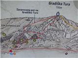 2
2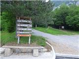 3
3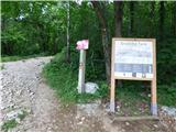 4
4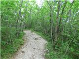 5
5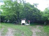 6
6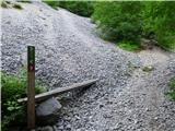 7
7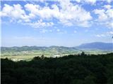 8
8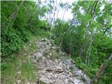 9
9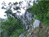 10
10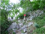 11
11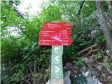 12
12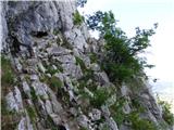 13
13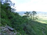 14
14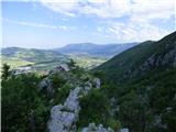 15
15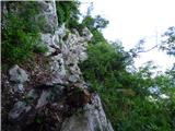 16
16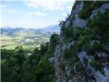 17
17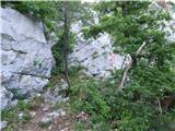 18
18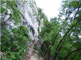 19
19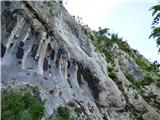 20
20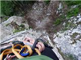 21
21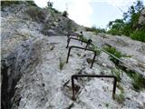 22
22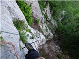 23
23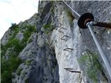 24
24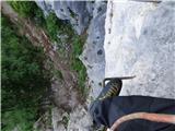 25
25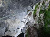 26
26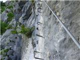 27
27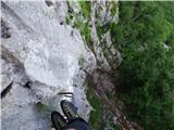 28
28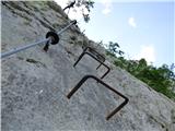 29
29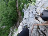 30
30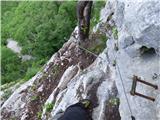 31
31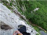 32
32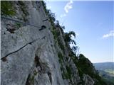 33
33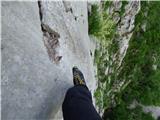 34
34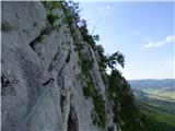 35
35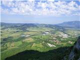 36
36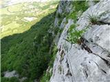 37
37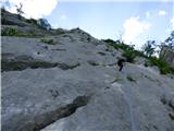 38
38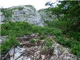 39
39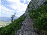 40
40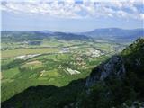 41
41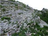 42
42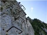 43
43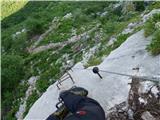 44
44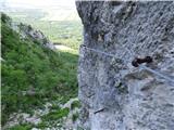 45
45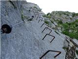 46
46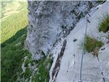 47
47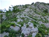 48
48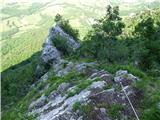 49
49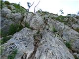 50
50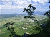 51
51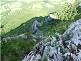 52
52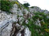 53
53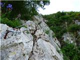 54
54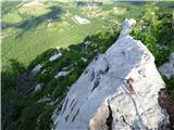 55
55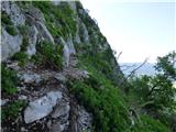 56
56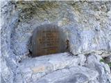 57
57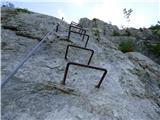 58
58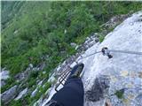 59
59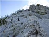 60
60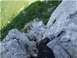 61
61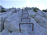 62
62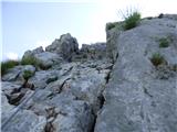 63
63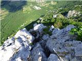 64
64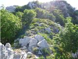 65
65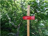 66
66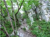 67
67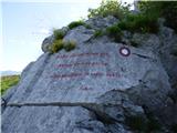 68
68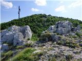 69
69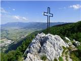 70
70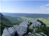 71
71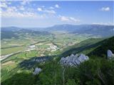 72
72
Discussion about the trip Gradišče pri Vipavi - Gradiška Tura (Otmar route)
|
| damijan6614. 06. 2019 |
Could someone make a comparison of this path with the red variant of Grančišče?
|
|
|
|
| JORDAN15. 06. 2019 |
Otmarjeva climbed today and I can praise the builders. Today it was dry and in my assessment technically a bit easier but longer than the red Graniščišče. Practice it first with Furlanova for warm-up.
|
|
|
|
| VanSims25. 06. 2019 |
Aha, I would say quite a bit easier.
Reaches some very short C's. The rest is easier, lots of long B's and A/B's. Not to underestimate though. Rather comparable to blue (somewhat harder).
For those progressing in ferratas by difficulty maybe: Furlanova, blue Mojstrana, Otmarjeva, then 2-3 a bit harder in between and then red Mojstrana.
|
|
|
|
| Jurc8925. 02. 2020 |
Is the path marked to go first to Furlanova, then descend to the start of Otmarjeva? Regards
|
|
|
|
| darinka425. 02. 2020 |
Everything is marked there. The path is also arranged so that you can bypass the demanding first part and go via Furlanova and continue on Otmarjeva to the top.
|
|
|
|
| Berstuk23. 10. 2020 |
We were there at the beginning of October - wonderful 
But I didn't notice (nor look) where one could bypass the first part of Otmarjeva.
I'm thinking of taking my parents, it wouldn't be a problem for mom, but dad hasn't done more than Hvadnik or Aljažev in Mojstrana yet. Physically he's excellently fit for his 67 years, but I wouldn't drag him through that part...
Is there any shortcut or sign?
Thanks
|
|
|
|
| bongo23. 10. 2020 |
The bypass junction (about 2-3 minutes after descending from Furlanova) is not marked, but you can't miss it. There is an information board by the path, and the bypass looks a bit overgrown, but it's not, just less trodden.
And kudos to PD Vipava for maintaining Gradiška Tura. Good luck
|
|
|
|
| Berstuk15. 11. 2020 |
Bongo, thanks for the info We'll go when they lift the measures 
|
|
|
|
| PUHIPUHI30. 04. 2021 19:55:11 |
I'm interested if anyone has experience, how quickly this wall dries after rain? If it rains again tonight, is a visit to this via ferrata sensible tomorrow morning, or will it be too slippery? Thanks
|
|
|
|
| kraška sapca8. 02. 2022 11:41:23 |
Yesterday 7.2.2022 I climbed Gradiška with a girl named Daša. DAŠA, if you're reading this, please contact me so I can send you the photos
Otherwise, response to the last comment: yesterday two who slept over at Tura camp said it was raining in the morning, when I arrived around 11 o'clock, the rock was already completely dry.
Both paths are well maintained, no damage, cables tight as strings. But it's not a category for beginners, in my opinion.
|
|
|
|
| Danak26. 11. 2022 12:53:10 |
Hello,
I have done the Gradiška tura several times, as well as all three via ferratas in the Glinščica valley. Which one would be suitable in terms of difficulty for the next challenge?
Thanks for the answers
|
|
|
|
| turbo27. 11. 2022 11:29:14 |
This would probably appeal to you, it's not overly demanding, but the surroundings are beautiful, say suitable for a change from the coastal lowlands to the Carnic highlands. Zermula via ferrata, then on to Zuc della Guardia, where there's another mini ferrata. Optionally before Guardia, a walk to the grassy Monte Pizzul, nice viewpoint. After the tour, delicacies at Lonice pass (passo Cason di Lanza), there also cheese to take home, maybe salami too
https://philippsteiner.eu/2019/09/monte-zermula-2143m-klettersteig/
https://escursionismo.tosolini.info/2016/06/ferrata-degli-alpini-al-zuc-della-guardia-salita-sul-monte-pizzul/
https://www.hribi.net/izlet/lonice___passo_del_cason_di_lanza___lanzenpass_zermula_via_ferrata/27/2589/5717
https://explorerfvg.com/luoghi/malghe/cason-lanza/
|
|
|
|
| avrikelj27. 11. 2022 22:28:50 |
Today, if you've climbed the harder Otmarjeva with sections marked D and E (with feet on friction and without help from pegs and footrests), then you won't have trouble on any Slovenian via ferrata.
|
|
|
|
| darinka43. 04. 2023 21:43:23 |
We went in the morning from Kamp tur. First to Furlanova. Descended to the start of Otmarjeva. No crowds at all. It was quite calm in the wall. Only a bit windy at the top. But the day was really nice - sunny.
|
|
|
|
| MinasTirith29. 04. 2023 18:28:24 |
Hello,
does anyone know if someone has hiked the Furlanova and Otmarjeva pot ferratas these days? I'm interested in the conditions, as I plan to do the hike (via ferrata) on May 15 or 16.
All information is welcome.
Thank you in advance for the information.
|
|
|
|
| bpavsic29. 04. 2023 19:33:53 |
Yes, we just climbed both today. Conditions were great.
We started around 8:00, weather was cloudy and just right for climbing. Later, when returning (around via Plaz to Gradišče, compared to the direct path down, this is the "highway", takes about 1h), the sun was out and it got quite hot.
The cables are all fine, taut. No crowds, met only a couple of people, even at camp Tura parking spots were free all day.
https://connect.garmin.com/modern/activity/11005455622
|
|
|
|
| MinasTirith16. 05. 2023 10:44:41 |
I was on the mentioned via ferrata on 16.5.2023. The path is well maintained, without peculiarities or dangers.
|
|
|
|
| balon1. 02. 2024 08:03:09 |
Hello, I'm interested in the conditions for the ascent? Is anything frozen, and what is the path like continuing to Abram?
|
|
|
|
| Darxta7. 04. 2026 16:03:55 |
We were on Otmarjeva on 4.4.2026. The trail is well maintained, without any peculiarities or rubble, occasionally one needs to be careful not to dislodge a pebble.
|
|
|
To post a comment you must log in:
If you do not yet have a username, you must first
register.