Hotavlje - Dom na Slajki (by road)
Starting point: Hotavlje (409 m)
| Latitude/Longitude: | 46,10720°N 14,11760°E |
| |
Route name: by road
Walking time: 1 h 15 min
Difficulty: easy marked way
Elevation gain: 380 m
Elevation difference along the route: 380 m
Map: Škofjeloško in Cerkljansko hribovje 1:50.000
Recommended equipment (summer):
Recommended equipment (winter):
Views: 6.027
 | 1 person like this post |
Access to starting point:
A) From Železniki, Kranj or Medvode we drive to Škofja Loka, and from there we continue driving in the direction of Gorenja vas in Poljanska dolina and Žiri. After Gorenja vas, in the settlement Hotavlje, at the crossroad behind inn Gostilna Lipan we leave the main road towards Žiri and we continue driving right in the direction of the ski slope Cerkno and village Leskovica. Immediately after the crossroad, we park in an appropriate place by the road.
B) From Horjul or Polhov Gradec we drive to Lučine, from there we descend into Gorenja vas. In Gorenja vas we continue left towards Žiri, then in Hotavlje at the crossroad behind inn Gostilna Lipan we continue right in the direction of the ski slope Cerkno and village Leskovica. Immediately after the crossroad, we park in an appropriate place by the road.
C) From Vrhnika, Logatec or Spodnja Idrija we drive to Žiri, and from there we continue driving towards Gorenja vas and Škofja Loka, and we drive on the main road only to the settlement Hotavlje, where we turn left in the direction of the ski slope Cerkno and village Leskovica. Immediately after the crossroad, we park in an appropriate place by the road.
D) First, we drive to Cerkno, and from there we continue driving through saddle Kladje (Podlanišče) towards Sovodenj. From Sovodenj we continue driving by the stream Hobovščica, and then in a somewhat larger crossroad we continue left in the direction of Gorenja vas (right Žiri). On the main road towards Škofja Loka we drive to the settlement Hotavlje, where we turn left in the direction of the ski slope Cerkno and village Leskovica. Immediately after the crossroad, we park in an appropriate place by the road.
Route description:
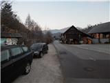
From the starting point, where nearby there is a vending machine of the farm pri Šupc we continue on the road towards the village Leskovica and in the direction of hiking paths to Blegoš, Ermanovec and Slajka. We walk for a few minutes by the edge of the road, partly also on a sidewalk, and then signs for Ermanovec and Slajka point us to the left (straight Blegoš), where over the bridge we cross Kopačnica, and immediately after the bridge at the church of St. Lovrenc we continue right and we gradually start ascending. At first we ascend past a few more houses, and then a marked footpath branches off to the left, and we continue on the road which leads us also past a trough with water. Higher the settlement ends, the road which offers nice views soon turns sharply left and gradually passes into the forest. Higher we cross the route of a marked path, and we follow the steep road to a marked crossroad from which we continue right in the direction of Dom na Slajki. There follows some more diagonal ascent and the road brings us out of the forest, where the marked path joins us. There follows a few minutes of walking on the road which turns semicircularly to the left, and then past the farm we reach the mountain hut Dom na Slajki.
Description and pictures refer to the condition in January 2020.

Photos:
 1
1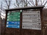 2
2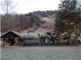 3
3 4
4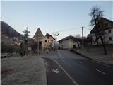 5
5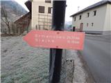 6
6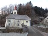 7
7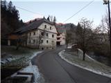 8
8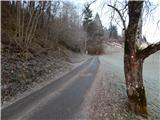 9
9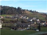 10
10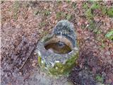 11
11 12
12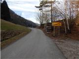 13
13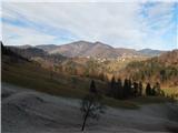 14
14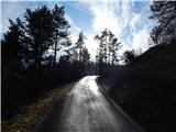 15
15 16
16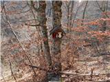 17
17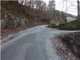 18
18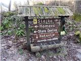 19
19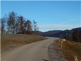 20
20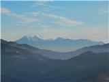 21
21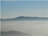 22
22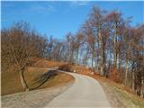 23
23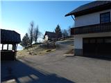 24
24 25
25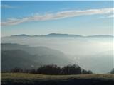 26
26
Discussion about the trip Hotavlje - Dom na Slajki (by road)
|
| Lucy15. 08. 2010 |
Hi, I would like to praise the Dom na Slajki. The owner is friendly and obliging. The surroundings are beautiful. From Slajka there is also a path to Ermanovec. When there is no wind, the walk from Hotavlje to Dom na Slajki is really pleasant.
|
|
|
To post a comment you must log in:
If you do not yet have a username, you must first
register.