Koča pod slapom Rinka - Turska gora (via Turski žleb)
Starting point: Koča pod slapom Rinka (1024 m)
| Latitude/Longitude: | 46,3696°N 14,5986°E |
| |
Route name: via Turski žleb
Walking time: 4 h 15 min
Difficulty: very difficult marked way
Elevation gain: 1227 m
Elevation difference along the route: 1225 m
Map: Kamniške in Savinjske Alpe 1:50.000
Recommended equipment (summer): helmet, self belay set
Recommended equipment (winter): helmet, self belay set, ice axe, crampons
Views: 117.658
 | 7 people like this post |
Access to starting point:
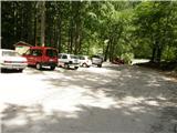
We drive to Luče (to here from Mozirje or via Kranjski rak) and further towards Logarska dolina. Soon after the village Solčava we come to the intersection, where the road to Logarska dolina branches off to the left. We turn left towards Logarska dolina (toll payment) and drive on the road to the parking lot at Koča pod slapom Rinka, where we park.
Route description:
From the parking lot, we go on a wide tourist path which starts gently ascending. After a good ten minutes of walking, we come out of the forest, where we come to a junction. We go left (right Orlovo gnezdo 3 minutes) in the direction of Dom na Okrešlju. The path ahead crosses a bridge and on the other side it starts ascending steeper. After a short ascent, the path brings us below the mountain walls, from where crossing to the top of the waterfall follows. This part is exposed to falling stones. After that, the path crosses Savinja again and then ascends upwards along the river with the help of stairs. Next we ascend on the right side (left bank) of Savinja. Soon, we come to the source of Savinja, where we again cross the water. On the other side, the path goes into a dense forest and after a short ascent, it brings us to the winter shelter on Okrešlju. We continue left and in a few steps we come to the mountain hut Dom na Okrešlju.
At the hut we go on a path in the direction of the Kamniško sedlo and Savinjsko sedlo saddles. Soon, we come to the edge of a panoramic meadow, where there is a junction. We continue straight through the meadow in the direction of the Češka koča and Kranjska koča mountain huts (left Kamniško sedlo). The path ahead crosses a torrent and then ascends along the scree slightly upwards. We soon come to the next junction, where we go left following the signs Turski žleb. At the junction there is also a memorial plaque. The path then starts ascending steeper and brings us to the entrance into Turski žleb. Because of falling stones on the path through the gully it is mandatory to use a helmet, and it is also highly recommended to use self-belaying. The path then leads us on the right side of the gully and soon brings us to the entry into the climbing part of the path. The path here vertically ascends on numerous brackets and then turns to the left and with the help of steel cables and brackets crosses more or less vertical wall above the gully. After the crossing over numerous brackets the path becomes gradually less demanding and soon the last steel cables end. Next follows a relatively steep ascent on scree terrain to the top of the gully. In the upper part, when we are ascending on the scree, we need to be very careful not to trigger stones. On the top of Turski žleb, where there is also a junction, we go left in the direction of Turska gora (right Skuta and Rinke) and on an increasingly panoramic path with the help of some pegs we ascend to the summit ridge, which we then follow to the peak. Walking on the ridge in dry conditions does not present major difficulties, but in snow on the summit ridge there is a great risk of slipping.
Koča pod slapom Rinka - Dom na Okrešlju 1:15, Dom na Okrešlju - Turska gora 3:00.

Photos:
 1
1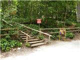 2
2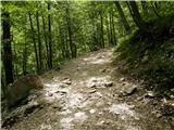 3
3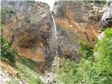 4
4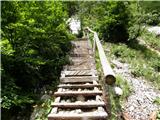 5
5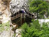 6
6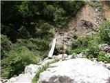 7
7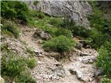 8
8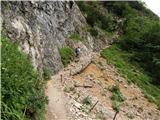 9
9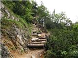 10
10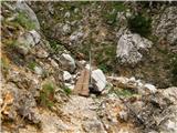 11
11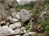 12
12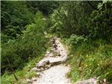 13
13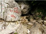 14
14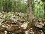 15
15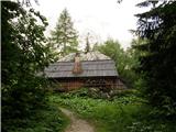 16
16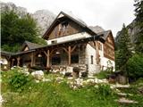 17
17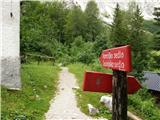 18
18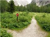 19
19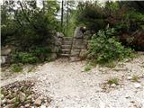 20
20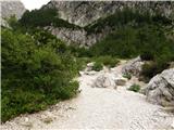 21
21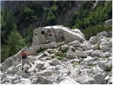 22
22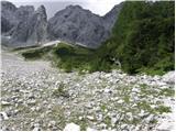 23
23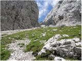 24
24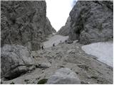 25
25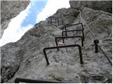 26
26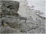 27
27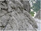 28
28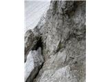 29
29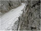 30
30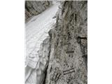 31
31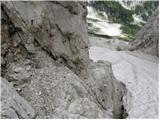 32
32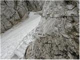 33
33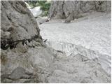 34
34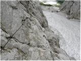 35
35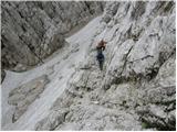 36
36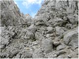 37
37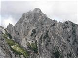 38
38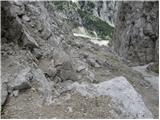 39
39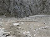 40
40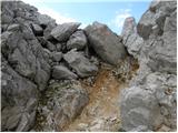 41
41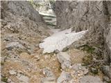 42
42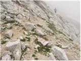 43
43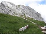 44
44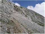 45
45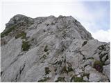 46
46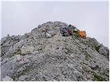 47
47
Discussion about the trip Koča pod slapom Rinka - Turska gora (via Turski žleb)
Show older messages
|
| sam-zee22. 08. 2008 |
Great tour. It's worth returning to Okrešelj (Frischaufov dom) via Kotličev and Kamniško sedlo to make a circular route. You just need enough time 
|
|
|
|
| IvoŠ23. 08. 2008 |
I agree! Great tour, I hiked it on July 30.
In the gully, the fixed cables were badly damaged and loose, so I crossed the critical section of the path as cautiously and slowly as possible. Adrenaline!!
Good thing fog accompanied me in the gully all the way to the exit
The path via Kotliče is really nice and excellently secured.
Rest on the meadow under Brana is welcome!
At Kamniško sedlo, HUGE portion of ričet with sausage, beer, and then descent to Frischauf!
Unforgettable tour!!
|
|
|
|
| sam-zee26. 08. 2008 |
The fixed ropes have apparently been renewed (see here).
|
|
|
|
| aljoša126. 08. 2008 |
They are not old. The one about catastrophic was posted on 11.8. On the mountaineering association on 20.8.
What's wrong here?
|
|
|
|
| panda27. 08. 2008 |
The damaged steel cable in Turski žleb has been replaced. Verified on Sunday, 24.08.2008. And it is excellently tensioned.
|
|
|
|
| Brane7127. 08. 2008 |
I misread the dates of the last entries on the PZS forum, I apologize.
|
|
|
|
| sam-zee27. 08. 2008 |
Brane, it happened to me too, no panic. I checked the dates 3 times before posting. 
|
|
|
|
| lokalc11. 09. 2008 |
Today (11.9.2008) I completed this tour and returned to Okrešelj via Kotličeve and Kamniško sedlo. From car to car 6 hours. The fixed cables in the gully have been renewed and there are no problems crossing. Still, my opinion of the gully: a unique adrenaline park
|
|
|
|
| MBrando23. 09. 2008 |
Well then. Has anyone been through the Gully in the last days? Icy pegs, anything? On Friday I'm heading there to check out the cold Turska gora a bit.
Papa
|
|
|
|
| sebanakis23. 09. 2008 |
Nice regards, last Wednesday Franc and I climbed to Turska gora. Attaching some photos. Today I was at Jezersko sedlo, first snow on the hut at Ledine, real blizzard, then twice to the summit. It was really nice.
|
|
|
|
| tom66626. 09. 2008 |
On Saturday 20.8. my colleague and I went through Turski žleb via Kotliče and Kamniško sedlo back to Okrešelj. No panic, but apparently it snowed a few days ago. Caution is not superfluous.
|
|
|
|
| miham28. 08. 2009 |
Considering the categorization of other local paths into "very difficult" and "extremely difficult", I think the via ferrata through Turski žleb could be classified as "extremely difficult."
LP,
Miha
|
|
|
|
| andrej7829. 08. 2009 |
With us, extremely difficult are only Kopiščarjeva on Prisojnik and Jalovec via Škrbina
lp
|
|
|
|
| ben29. 08. 2009 |
In our area, in Slovenia's territory, there is no extremely difficult path. The closest to us are in the Western Julians, namely Via della Vita to Vevnica, Via Italiana to Mangart, and Via Amalia to Montaž. And now of course also the via ferrata on Cjajnik, which is located in the Karavanke.
Best regards B
|
|
|
|
| miham31. 08. 2009 |
I wanted to say that this via ferrata seemed to me a grade harder than the other "very difficult" ones in the Kamnik-Savinja Alps. Although it might be more sensible to classify many "very difficult" ones among "difficult" routes.
This is becoming beating empty straw, so I hope the debate on this topic is over
Best regards,
Miha
|
|
|
|
| NEIC00831. 08. 2009 |
Try Mrzla gora and then compare with Turski žleb...
|
|
|
|
| Luciano678. 09. 2009 |
Hats off to the photographer for the beautiful photos!
|
|
|
|
| jany198028. 09. 2009 |
Hello mountain lovers!
I'm just a beginner, but I'm learning mountaineering knowledge and everything that goes with it quickly.
In 2009 I started conquering the Kamnik Alps (the most beautiful in Slovenia for me).
The first easier hike was to Matkov kot (to the shack), followed by a hike to Turska gora, Skuta!
But I have one question for you, dear hikers and mountain lovers!
I'm interested in which path in the Kamnik Alps is among the most difficult and most dangerous?
Because there's a lot of talk on this topic, but everyone has their own opinion.
Thank you for your answer and see you above 2000m
janez
|
|
|
|
| andrej7828. 09. 2009 |
Mrzla gora and Kočna.
regards
|
|
|
|
| jany198028. 09. 2009 |
Thanks Andrej78!
I hope to head to Mrzla gora this weekend too!
Judging by the pictures it looks very challenging
|
|
|
|
| aonuk127. 03. 2011 |
26.3.2011 Turski žleb - Turska gora - Kotliči - Okrešelj in pictures.
|
|
|
|
| kindir28. 03. 2011 |
jany1980... hope Mrzla gora will wait
|
|
|
|
| planinka987213. 07. 2011 |
I'm interested in the time for the path Okrešelj - Turska gora - Brana - Kamniško sedlo - Okrešelj. and the difficulty of the path. lp
|
|
|
|
| ljubitelj gora17. 07. 2011 |
Through Turski žleb it is passable without problems, snow does not hinder us on the way, but it is still in the gully
|
|
|
|
| Ceri28. 07. 2011 |
Yesterday did a loop "Okrešelj-Turski žleb-both Rinki-Turska gora-Kamniško sedlo" in just eight hours, but I hiked really fast in Turski žleb half hour of climbing fun - nothing special, suitable for any hiker with some experience - hard for me to find bearings in upper gully part and can't imagine descent here  trail over cirques really nice - very varied - up and down - bit of climbing with mild adrenaline here and there probably great views too, but no luck as clouds raced around... met whole ibex family at Rinki, two chamois on cirques grazing peacefully by trail and some smiling hikers all way nice! trail over cirques really nice - very varied - up and down - bit of climbing with mild adrenaline here and there probably great views too, but no luck as clouds raced around... met whole ibex family at Rinki, two chamois on cirques grazing peacefully by trail and some smiling hikers all way nice!
|
|
|
|
| nata2428. 07. 2011 |
Eight hours doesn't really seem that fast to me...
|
|
|
|
| andrej7829. 07. 2011 |
Hiked it last year in 6 hours at a moderate pace, but speed is relative and when hiking in mountains it's not important, except if darkness or storm catches you.
Otherwise congratulations on this nice tour, Turski žleb and Kotliči are no joke and quite a few people have turned back there already.
best regards
|
|
|
|
| Ceri4. 08. 2011 |
@nata24: If you start from the bottom = Logarska dolina (slap Rinka), 8h is quite fast or even a bit too fast, because if the weather doesn't chase me, I really like to enjoy the peace, surroundings and views <3
|
|
|
|
| geppo4. 08. 2011 |
I'd say that through Turski žleb is probably harder. But the difference is that Kopinškova is much higher up and exposed compared to the path running in the wall of Turski žleb.
To Turska gora, which approach do you take?
|
|
|
|
| geppo4. 08. 2011 |
Nice path and going up the gully will be easier than down. Just be careful at the gully exit (nasty scree).
best regards
|
|
|
|
| Marky8. 08. 2011 |
For the weekend we went with friends to Turska gora. The path led us: Slap-Okrešelj-Turski žleb-Turska gora-Kotliči-Kamniško sedlo-Okrešelj-slap. To the summit we needed approx. 3h and 30min, similarly on the descent, because upon arrival at the top it started to rain lightly.
If you decide to go through the gully, I recommend a helmet as well as a via ferrata set. It really came in handy for us at Kotliči because of the wet rocks.
I also photographed the entire path, so if anyone is interested, you can view the pictures at www.m-foto.si
Regards until next time
|
|
|
|
| Marky21. 06. 2012 |
Dear visitors..
Those who decide to conquer Turska gora via Turski žleb, I kindly ask you to be very careful when exiting the fixed cables onto the scree slope, as there is a high risk of dislodging stones and endangering others (those behind you). Please stick close to the wall and do not take shortcuts across the scree, because for 10 minutes of saved time, you could injure someone.
Thank you!
|
|
|
|
| Marky2. 07. 2012 |
14 days ago I wandered a bit around KSA and among other things climbed Turska gora starting from Okrešelj via Turski žleb, descended via Kotliče to Kamniško sedlo and continued to Okrešelj and to Rinka waterfall. You can see photos of the ascent at M-foto.si
|
|
|
|
| Gizmo22. 08. 2012 |
Nice greeting.
I have one question. Since I'm planning to tackle the ascent to Turska gora with a group this weekend via the mentioned route and descend back through Kotliči, I'm interested in the following. What is the approximate height of the path in the secured section through the gully above the gully bottom? I have some ascents in the KSA behind me, but out of caution, it still interests me. Technically, walking on stirrups and using fixed cables is not foreign to me, but with each ascent I also get more accustomed (healthily) to the distance from the ground  . It mentions a slightly later entry bypassing the vertical ladders... Does this entry make the difficulties much easier? Fitness is not an issue. . It mentions a slightly later entry bypassing the vertical ladders... Does this entry make the difficulties much easier? Fitness is not an issue.
Thanks for the opinions.
Best regards
|
|
|
|
| geppo22. 08. 2012 |
With a slightly later entry, you won't gain much. Later, as you ascend towards the top of the gully, the height increases a bit more. I would recommend that you boldly enter the vertical ladder. You must realize that pegs await you further along the route (Kotliči)!!. I would rather warn you that the exit from the gully is usually more problematic. There are no pegs or anchors there, but nasty scree that requires caution against slipping.
Best regards
|
|
|
|
| Gizmo22. 08. 2012 |
Thanks Geppo. Yes, I know that Kotliči are spiced up, at least from the photos it's evident. Aerial exposure might give me a bit of trouble. On the path to Ojstrica, Brana, Kamniško sedlo (from Okrešelj) I enjoyed it. Hard to compare, except on the spot itself.
Best regards
|
|
|
|
| geppo22. 08. 2012 |
If you enjoyed those paths, then you won't have trouble in the gully either. The distance from the scree to the pegged path above is not high. Somewhere just a few meters up to about 20m (I've never measured this height and it's more by eye). Get used to not looking down at all but focusing on safe progress forward...
Best regards
|
|
|
|
| panda22. 08. 2012 |
I would add a bit more: Kotliči are indeed a bit spiced up, but: the bottomless barrel is wired, later the descent is unsecured (at least as far as I remember), when you reach the western side it's all pegged, around Kotliči (the last part to the plateau, I'd say the saddle between T. gora and Brana) is also wired, but there are no good footholds, a bit of caution and it's fine. If you're heading to the starting point at Okrešelj, you can descend a bit from that "saddle" - free climb not demanding to the other side (SV gully descends quite a bit lower to Okrešelj) and scramble down the scree until you join the descent path from K. sedlo. That way you'll save about half an hour, as the path through Boštjanco is a bit time-consuming, and rocks often fly down from Brana. The decision is yours.
|
|
|
|
| dogma31. 10. 2012 |
Has anyone been up there in the last days, what's the condition like, regarding snow I mean!?
|
|
|
|
| ula18. 11. 2012 |
Winter equipment needed, crampons and ice axe, helmet also not superfluous because it's quite crumbly. On the path there are snow patches where it's very hard to cross without winter gear. Lp
|
|
|
|
| ms_primoz24. 10. 2013 |
does anyone know if there's any snow on this path?
|
|
|
|
| katja8725. 10. 2013 |
We went on Sunday (20.10.2013) under Turski žleb to Savinjsko sedlo and further to Ledinski vrh and Storžek.
The entire path to and through Turski žleb is dry. Those last 20 minutes to Turska gora shouldn't be problematic in my opinion, even if there's some snow, as it's not exposed. Otherwise, judging by the surrounding peaks, there's no snow on Turska gora. Since it hasn't snowed these days, you can set off on this tour without problems in my opinion
Happy trails!
|
|
|
|
| nkamin2. 11. 2013 |
On Friday first time through Turski žleb to Turska gora, descent via Kotliče. Beautiful day, wonderful views, path quite demanding. Thanks to Marko for the help and kindness, as he took the time and descended with me via Kotliče to Kamniško sedlo.
|
|
|
|
| Akrstinc24. 04. 2014 |
#nightclimb what are the conditions? Is any winter gear still needed?
|
|
|
|
| geppo24. 04. 2014 |
Conditions still "winterly" and take some winter gear with you.
regards
|
|
|
|
| klin8424. 04. 2014 |
13.4. I went along this path with a buddy, from the junction onwards without crampons and ice axe I wouldn't go... towards noon the snow softens, otherwise OK.
|
|
|
|
| redbull25. 04. 2014 |
The snow in the gully will remain until July.
|
|
|
|
| Roman055. 06. 2014 |
Next week I would venture through Turski žleb to Turska gora, but does anyone have fresh information on the conditions?
|
|
|
|
| danilo bor15. 06. 2014 |
On 21.6 I would go through Turski žleb, interested in snow conditions or passability.
|
|
|
|
| simonmanutd27. 07. 2014 |
Conditions in the gully? On Thursday I'd go through it to Skuta.
|
|
|
|
| Akrstinc31. 07. 2014 |
Conditions are OK. Snow starts a little before the via ferrata entrance and you climb only about 10 m on it. Higher up, snow does not hinder access to Turska gora.
|
|
|
|
| rene laznik9. 09. 2014 |
Hello, I'm a fairly new hiker and I'm wondering if it's really necessary to go through the climbing section with a harness and helmet, thanks in advance for the answer
|
|
|
|
| črna murka9. 09. 2014 |
Turski žleb is very demanding. If you're a new hiker, I recommend a harness. The cable on the wall is torn off in one place and replaced with a rope. A helmet doesn't hurt either if by chance a stone flies down from above. Safe stepping!
|
|
|
|
| rene laznik9. 09. 2014 |
oh I forgot, I'm interested what would be smart to take on such an expedition
|
|
|
|
| gorolazka9. 09. 2014 |
If you don't know what to take with you and plan to go alone, I advise you to start with easier hikes or trips.
|
|
|
|
| rene laznik10. 09. 2014 |
Thank you very much for the answers, I'm interested where there could be some easier tour that also has a climbing part, I'm from Styria
|
|
|
|
| geppo10. 09. 2014 |
If you really have no experience, it's best to find someone for the start who takes you along, teaches you a bit and sees what you're capable of..??
just something to think about!
someone suggested to me several times to take him to Košutnikov turn from the Austrian side. He liked the photos he saw on my computer. Then I took him once to Rogatec from Kala to see how he'd manage? I can say that during the tour he didn't show any special fear, but after that he never mentioned to me again that he wanted to go higher...
best regards
|
|
|
|
| Keko10. 09. 2014 |
Since you mentioned Okrešelj as a starting point, I would suggest the path over Kamniško sedlo to Brana and back. On the way there will be something for everyone. A bit of fixed cables, a bit of easier climbing and also some deeper views down will be found.
|
|
|
|
| majcen11. 09. 2014 |
Both geppo and keko have given more than sensible advice. Given the questions you're asking, it would be wise to choose the path to Kamniško sedlo and even on the less demanding path, invite someone with experience along.
|
|
|
|
| Grenaleva12. 09. 2014 |
What about from Česka koča to koča Na ledinah, and then you can extend to snežišče pod Skuto, or to Savinjsko sedlo
|
|
|
|
| rene laznik19. 09. 2014 |
thanks for the suggestions, I will first tackle something easier and go on harder tours at least a couple of times with some company
|
|
|
|
| kamenko7. 08. 2015 |
We're heading to Turska gora via Turski žleb. Interested in the condition of the steel cables. (they are supposed to be torn). Thanks for the info.
|
|
|
|
| kamenko1. 09. 2015 |
On Sunday to Turska gora through Turski žleb, return via Kotličev to Kamniško sedlo and via Okrešelj to starting point. Very nice tour. Protections through the gully OK.
|
|
|
|
| brele18. 06. 2016 |
Nice greetings!
In the coming days we plan to hike the trail from Rinka waterfall to Okrešelj and then through Turski žleb to Turska gora. We would return via Kotliče. I'm interested if the trail is suitable for a larger group of hikers and what the current conditions are like?
|
|
|
|
| ravnjak19. 06. 2016 |
Today 18.06. I was exactly on this trail. For now I advise against a larger group through here, as the only possible passage is using crampons and ice axe through the entire gully. Except for the entry to the climbing part, all pegs and wires are under snow. But the base is relatively stable and with equipment there are no problems.
|
|
|
|
| brele20. 06. 2016 |
@ravnjak
Thanks for the information. Do you think the snow will melt by 10.7., that's when we plan to summit Turska gora?
|
|
|
|
| 1Vid210. 08. 2016 |
I'm interested in what the situation is like through the gully, thanks
|
|
|
|
| bobo10. 08. 2016 |
The path is dry throughout. At two spots the steel cable is torn, but a rope is currently installed there enabling safe passage. In the upper section there's quite a lot of scree, so take careful steps.
|
|
|
|
| leskovarz1. 09. 2016 |
Is that steel cable already new or is it still just a fixed rope?
|
|
|
|
| lena_ala27. 02. 2017 |
Yesterday super conditions, quite a bit of fresh snow. Views of course phenomenal. Winter gear of course necessary.
|
|
|
|
| seinfeld6. 08. 2018 |
Yesterday we went to the summit via this path. The fixed protection is in perfect condition, the upper scree section is annoying, where you take 2 steps forward, one back. Since we were already at the top of the gully at half past seven, we continued to Mala Rinka and then to Turska gora. We returned to the valley via Kotliče and Kamniško sedlo. For me, the path through Turski žleb was not problematic, it leads along the scree all the time. The path through Kotliče is much more demanding, quite exposed and dynamic, but excellently protected. Anyone who wants to enjoy via ferrata will find this an excellent choice.
Altogether we covered just under 11km and 1600m of elevation gain in seven and three-quarter hours. Helmet mandatory on the entire path, rocks often fly.
The mountains were extremely crowded yesterday, there were queues snaking on Brana, at Kamniško sedlo and Okrešlju it was like an anthill.
|
|
|
|
| anatasic31. 03. 2019 |
Yesterday at the top of Turski žleb I found a thin men's snowboard jacket. If anyone misses it, please call 070659024.
|
|
|
|
| nomen.nescio16. 07. 2019 |
Nice regards.
What are the conditions on the path through Turski žleb, is it still snowy?
|
|
|
|
| sh16. 07. 2019 |
The path is snow-free and impeccable.
|
|
|
|
| trdi25. 07. 2019 |
Fixed protection in excellent condition, no ropes anymore, also in the upper part no more problems over the scree, because there is a wire rope along the wall.
|
|
|
|
| SunnyDay28. 07. 2019 |
Which direction is easier from Rinka Waterfall, up through Turski Žleb and down Kotliče or vice versa?  Thank you very much! Thank you very much!
|
|
|
|
| zokipoki28. 07. 2019 |
Both variants are demanding. Regards
|
|
|
|
| SunnyDay28. 07. 2019 |
Yes, that's clear to me But probably one is still easier or more recommended for descent than the other, that's why I'm asking. 
|
|
|
|
| trdi28. 07. 2019 |
Usually one goes up through the gully and down through Kotliče, but the path in the gully is better protected than through Kotliče. Technically, the gully is of course more demanding, through Kotliče there is more scree on the path and a few unprotected sections.
|
|
|
|
| redbull29. 07. 2019 |
You go along the marked path and not directly down the scree gully to the junction with Kotliče, which is certainly overall a bit more difficult than through Turski Žleb. No one said in the gully that you have to go right next to the cable, you can go under it on the scree by the wall (if there's no snow), which means no difficulty.
|
|
|
|
| veja514. 08. 2019 |
Hey Trdi,
how far are the fixed cables installed?
To the top of the gully?
Last year I saw them only somewhere up to the beginning of the scree.
Best regards! Venčeslav.
|
|
|
|
| čebejla14. 08. 2019 |
The fixed cable is installed to the top, real pleasure, they did it nicely, so now only a traverse of 100m to the exit
Hehe Redbull, you say no difficulty(for you surely not), but judging by others it's obviously not that easy. or rather full of
|
|
|
|
| veja516. 08. 2019 |
Čebelja,
thanks for the info. Will have to go see this addition.
Best regards. Venčeslav.
|
|
|
|
| mersudin1. 09. 2019 |
Today I hiked this path to the top of Turska gora with my daughter and we had no problems even though this gully is BAD (UGLY) we continued through the cirque to Kamniško sedlo for a beer and rest... then down to the valley.. perfect day.
|
|
|
|
| CarpeDiem2471. 02. 2020 |
Today in the Žleb there is 30 to 50 cm of snow, which is not icy, but don't go without (proper) crampons and of course an ice axe.
|
|
|
|
| Turbolazec19. 04. 2020 |
Hello! I'm interested in the conditions, has anyone been there recently? Thanks and best regards
|
|
|
|
| ločanka20. 04. 2020 |
By the time you can go up there, the conditions will have changed even more
|
|
|
|
| mirank20. 04. 2020 |
I assume based on the question that you are either a beginner or a provocateur with experience??? If you're the latter, you already know what to do and if it doesn't go, you turn back, regardless of whether you're going to Triglav, Vrtača or Turska gora. Usually those who ask about all three peaks at once are the ones who have no idea
|
|
|
|
| mojccccc17. 06. 2020 |
Hello! I'm interested in the current conditions on this path to Turska gora these days. Is there still any snow?
|
|
|
|
| biba17. 06. 2020 |
Snow is still in the gully (winter gear). In the middle section, the fixed cables are still under snow. The summit is however bare.
|
|
|
|
| dprapr17. 06. 2020 |
Abseil through the Turski žleb, interesting.
So that now according to SVK on secured paths this also becomes recommended on snowfields.
|
|
|
|
| redbull17. 06. 2020 |
probably it was training, otherwise I really don't know what they would abseil
|
|
|
|
| djimuzl17. 06. 2020 |
Abseil instead of crampons and ice axe.. Hmm, interesting technique..
|
|
|
|
| dprapr18. 06. 2020 |
Dejan, I agree.
Even if you don't take any gear for the climbing section with you, a hammer with an adze is sufficient for the descent.
|
|
|
|
| jax18. 06. 2020 |
I don't know. To me, in the given situation (they had rock climbing gear with them, not winter gear + easy rappel option on the secured path's bolt), rappelling seems by far the safest option. Maybe someone has a different opinion.
|
|
|
|
| Klemen2418. 06. 2020 |
Mr. -energy drink- always has to chime in. Well, they did rappel.
|
|
|
|
| dprapr18. 06. 2020 |
I was the first to comment and I don't drink energy drinks.
There's nothing wrong with them choosing the safest descent by rappelling probably just with climbing gear. But it seems to me that there's no longer that freedom of movement like there used to be. Everything is secured, with a hundred types of gear, you have to be clipped in at every moment,... This has carried over from secured paths to alpinists too.
Back then we used to rush down the slabs in Adidas shoes. With a hammer in hand, as I mentioned above. Now it's good that better footwear is available.
|
|
|
|
| djimuzl18. 06. 2020 |
Like in other segments of our lives. Safety and "safety" have prevailed over freedom and "freedom".
|
|
|
|
| Smilodon5. 07. 2020 |
Today we were on this path. Wonderful. I suggest to the site moderators to slightly correct the walking time. On the sign at the hut after Rinka waterfall it's marked 3:30; we, with average pace, needed a bit less. So, these 4:15 written here are too much.
|
|
|
|
| nimampojma24. 07. 2020 |
Hi, is there still snow at the gully? I plan to do a loop this weekend.
|
|
|
|
| bongo24. 07. 2020 |
Snow in the gully is there, but not obstructive. All cables are exposed, protections ok, bypass of entry section possible. Same all ok via Kotlice if you go. Good luck
|
|
|
|
| smatjaz25. 07. 2020 |
Just be careful of hikers above and below you, as it's almost impossible to cross the gully without dislodging stones that fly down the whole gully.
|
|
|
|
| cegy116. 08. 2021 06:37:29 |
What is the current condition of the passage?
|
|
|
|
| kozuc5. 09. 2021 14:40:13 |
Yesterday up here for the first time. So many markers in the gully it's almost kitschy. At the top a bit fewer but you can't miss it anyway, even in fog like yesterday.
This walking time is greatly inflated though. Already at the hut below it says 3:30, and that's still too much. If you're fit, you're up in well under two hours.
|
|
|
|
| Nihče14. 03. 2022 14:43:06 |
Hello,
Yesterday, on Sunday 13.03, while descending from Turska gora towards the hut at Rinka waterfall, I lost my ice axe somewhere. If anyone found anything, I'd be very happy if they contact me at 041499649
Thank you and best regards!
|
|
|
|
| plaNinaPirsMajcen30. 06. 2025 18:24:42 |
Hi,
has anyone been recently through Turski žleb to Turska gora?
Interested in the condition of the fixed protections and if there's still any snow in the gully that would hinder the ascent?
Thanks, best regards
Nina
|
|
|
|
| garmont30. 06. 2025 21:27:53 |
All clear of snow. Protections OK.
|
|
|
|
| plaNinaPirsMajcen20. 07. 2025 10:27:44 |
Hi, sharing my yesterday's experience.
https://youtu.be/R2nMY5eTLbs?si=ap04AbSK-y2uIUEw
I think the trail to Turska gora via the gully should be renovated (compared e.g. to Rudijeva vertikala, which is officially closed).
In the upper part of the gully, the trail was destroyed by a rockfall right where you cross the steepest scree slope.
Also in the lower part, at the memorial, where you turn left from the path to Savinjsko sedlo, there's about 200m elevation of loose walking over the fall, two steps forward, one back, just an arrow at the fork and one cairn ahead nothing.
We didn't finish the trail as it didn't seem quite safe, didn't want to risk it.
But I experienced the climbing part of Turski žleb, which was my wish. The entry is impressively vertical, recommend SVK. Can bypass the harder part by ascending easily up the gully bottom on sand higher and joining the wall.
Best, Nina
|
|
|
|
| JureH0110. 08. 2025 14:30:30 |
Hello,
yesterday I was on Turska gora through the gully. The path through the gully is damaged in two places.
In one section, a piece of the wire rope is torn off along with a piece of rock, which is not a problem though because there are also pegs there and the next wire is 1.5m further.
The other section was destroyed by a landslide at the last approx. 30m of the wire. The wire is intact but in places more than 2m off the ground and can't be held, so if steep scree is a problem for you, it's best to wait until it's repaired.
The path towards the gully from the memorial plaque is marked with cairns at the beginning where you turn towards the gully, and at the end of the landslide where you rejoin the existing path.
Best, Jure
|
|
|
|
| asdf10. 08. 2025 20:32:16 |
"The cable is intact but in places more than 2m above the ground and cannot be held, so if steep scree is a problem for you, it's best to wait for it to be fixed."
It was like that last year too, so those waiting for repairs can wait forever.
|
|
|
|
| renko5. 12. 2025 20:57:50 |
and is the gully sufficiently filled for winter ascent?
|
|
|
To post a comment you must log in:
If you do not yet have a username, you must first
register.