Koča Pordenone - Monte Pramaggiore
Starting point: Koča Pordenone (1200 m)
Walking time: 4 h
Difficulty: difficult marked way
Elevation gain: 1278 m
Elevation difference along the route: 1278 m
Map: Tabacco 21 1:25000 ali Dolomiti Friulane 1:40000 (Meridiani Montagne)
Recommended equipment (summer): helmet
Recommended equipment (winter): helmet, ice axe, crampons
Views: 7.631
 | 3 people like this post |
Access to starting point:
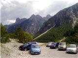
The Cimoliana Valley above the village of Cimolais is reached via local roads that branch off from the motorway exit Videm/Udine (Sud or Nord – in both cases we follow the signposts for Spilimbergo and Maniago), or also from Longarone at the end of the Venice–Cortina d'Ampezzo motorway. In Cimolais we turn onto a partly asphalted road that in some places runs over huge gravel deposits, about 10 km up the valley to the parking lot below the Pordenone mountain hut.
From Gorizia to Cimolais is at least 119 km (nearest variant) or 148 km (fastest, partly motorway variant).
Route description:
From the parking lot we continue past the gate along cart track No. 361 towards the mountain pasture Casera Meluzzo. On wide gravel areas we follow the cairns and orient ourselves by the nice wooden signposts of the Natural Park of the Friulian Dolomites, which at the end of the gravel areas direct us onto path 362. The path runs along the stream, turns into the forest, where it changes into a comfortable, shady footpath. At the only junction we turn right onto path 366 and along the botanically rich lateral moraine of the former glacier, below the walls of Croda del Sion and Il Castiela, we reach the Sidon notch. All the time magnificent views open up behind us and in fine weather we can admire the Friulian Dolomites as well as the true Dolomites. Standing out are Monfalconi, Laste, Duranno and Cima dei Preti, and behind them Pelmo. Above the notch the secured path from the mountain hut Flaiban-Pacherini (or from Forni di Sopra) joins us. The path runs at the junction of the wall and scree, then with the aid of a few metres of steel cable it ascends onto the ridge. A view opens onto the two-thousanders above Val Setimana, along which one of the approaches to our mountain runs. Red dots lead us through the easiest passages in the steeper terrain, where we occasionally help ourselves with our hands. At the summit a small cross surprises us, and perhaps even an ibex.

Along the route: Ricovero Casera Meluzzo (1163m)
Photos:
 1
1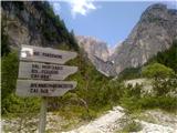 2
2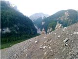 3
3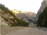 4
4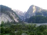 5
5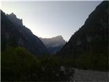 6
6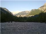 7
7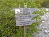 8
8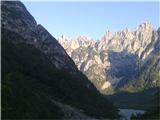 9
9 10
10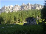 11
11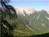 12
12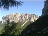 13
13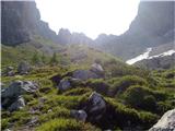 14
14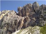 15
15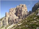 16
16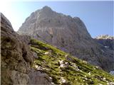 17
17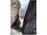 18
18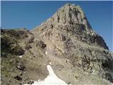 19
19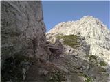 20
20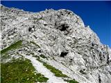 21
21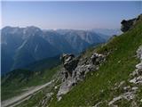 22
22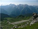 23
23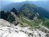 24
24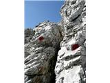 25
25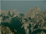 26
26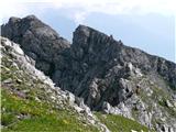 27
27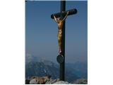 28
28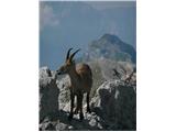 29
29
Discussion about the trip Koča Pordenone - Monte Pramaggiore
|
| Pi_is_exactly_312. 08. 2019 |
Due to the autumn storms and floods of 2018, there is a warning at the entrance to the Cimoliana valley about continuing at your own risk. Nevertheless, the road is (already) normally passable and not problematic... On the way further to Pramaggiore there are no peculiarities, everything from the description still holds. The path from the Cimoliana valley is one of the nicer ones in the Carnics for my taste (endless scree at the start of the tour, picturesquely jagged mountains, glacial moraines, almost tame ibex...).
|
|
|
|
| mirank13. 08. 2019 |
Try next time from Forni di Sopra past the Flaiban Pacherini hut; it can be done almost as a complete loop tour , but about the mountains around there I wouldn't , but about the mountains around there I wouldn't . Also the starting point itself is at least 20km closer and easier to reach, but Val Cimoliana really is something special, even though the road, especially towards the end, is more suitable for higher vehicles. . Also the starting point itself is at least 20km closer and easier to reach, but Val Cimoliana really is something special, even though the road, especially towards the end, is more suitable for higher vehicles.
|
|
|
To post a comment you must log in:
If you do not yet have a username, you must first
register.