Koča pri Savici - Lake Zeleno jezero
Starting point: Koča pri Savici (653 m)
| Latitude/Longitude: | 46,28960°N 13,80220°E |
| |
Walking time: 4 h 50 min
Difficulty: difficult marked way
Elevation gain: 1335 m
Elevation difference along the route: 1390 m
Map: Triglav 1:25.000
Recommended equipment (summer): helmet
Recommended equipment (winter): helmet, ice axe, crampons
Views: 8.722
 | 2 people like this post |
Access to starting point:
From the Ljubljana - Jesenice motorway, take the Lesce exit and follow the road towards Bled and further towards Bohinjska Bistrica. Continue driving towards Bohinjsko jezero (Ribčev Laz), where you reach a crossroads and continue straight along the left (southern) side of the lake in the direction of Ukanc and the Savica waterfall. Follow this increasingly narrow road to the large parking lot at Koča pri Savici. Paid parking.
Route description:
From the parking lot, head right towards Črno jezero, Koča pri Triglavskih jezerih and Hotel Zlatorog (straight ahead Slap Savica and Dom na Komni). The path initially follows a gravel road that crosses the Savica river over a bridge. Just beyond the bridge, signs for Komarča direct you left (straight to Hotel Zlatorog) onto a path that is initially still fairly wide and relatively gentle through forest. The path soon begins to climb more steeply and a little higher brings you to the point where the path to the Savica spring and Velika Savica cave branches left; continue right on the increasingly steep path.
The well-maintained and relatively wide hiking trail soon moves onto very steep, slippery slopes of Komarča, where there is also a high risk of rockfall. The path continues steeply up the mostly forested wall of Komarča, with fixed cables assisting on the harder sections.
Higher up, views open towards Bohinj, and the path reaches a short technically demanding section where, with the help of staples and a cable, you cross an otherwise not very exposed gully. The path continues steeply for a while longer and, with some fixed protections, brings you to the edge of Komarča, from where there is a fine view back to the starting point. A short moderately steep ascent follows, then the path begins to descend gently towards Črno jezero, reached in less than five minutes of further walking.
Near the lake is a marked junction where the path to Planina Viševnik and Pršivec branches right; continue slightly left on the marked trail that bypasses Črno jezero on its right side. On the far side of the lake, the path from Dom na Komni joins from the left, and you continue on the relatively gentle trail along the edge of Lopučniška dolina. Higher, the path begins a moderate ascent and, along the edge of overhanging cliffs, reaches a small spring that dries up in dry periods.
Continue on the marked trail, which near Bela skala turns sharply right and climbs steeply. After a few minutes of steep ascent, the path levels and reaches a marked junction where the trail from Planina Blato (via Prode) joins from the right. Continue left towards Koča pri Triglavskih jezerih on the relatively gentle trail, reaching Dvojno jezero in ten minutes. The marked trail bypasses the lake on the right and, before reaching the far side, arrives at a junction where the path to Štapce and Mala Tičarica branches right.
Continue straight here and reach Koča pri Triglavskih jezerih in a few minutes.
From the hut, continue towards Triglav, Dolič, Hribarice, Prehodavci and Veliko Špičje; the path first passes the dam and artificial lake Močivec. It bypasses the lake on the right (eastern) side and then ascends moderately through Dolina Triglavskih jezer, which is covered in increasingly sparse forest.
Still in the band of sparse forest, the path forks; continue on the slightly right branch towards Prehodavci and Hribarice (left branch to Veliko/Lepo Špičje across the Zgornje Komne plateau), passing initially through sparse larch forest, then below the scree slopes of mighty Kopica and later Mala Zelnarica. Later the path climbs briefly more steeply to a small pass with a fine view of Jezero v Ledvicah.
The marked trail bypasses that lake on the right, continuing over extensive scree at the foot of both Zelnarice. Beyond the lake, the path returns from the scree to Dolina Triglavskih jezer and continues with a relatively gentle ascent. The fully alpine trail climbs briefly more steeply higher up, then levels completely and, after a few more minutes, reaches Zeleno jezero.
Starting point - edge of Komarča 1:35, edge of Komarča - Črno jezero 0:05, Črno jezero - junction above Lopučniška dolina 1:15, junction above Lopučniška dolina - Dvojno jezero 0:10, Dvojno jezero - Koča pri Triglavskih jezerih 0:05, Koča pri Triglavskih jezerih - branch for Veliko Špičje 0:25, branch for Veliko Špičje - branch to Jezero v Ledvicah 0:30, branch to Jezero v Ledvicah - Zeleno jezero 0:45.

Along the route: Komarča (810m), Rob Komarče (1295m), Vrh Komarče (1313m),
Črno jezero (1294m), Bela skala (1575m), Razpotje nad Lopučniško dolino (1671m), Ruski grob (1686m), Dvojno jezero (1689m),
Koča pri Triglavskih jezerih (1685m), Močivec (1690m), Odcep za Veliko Špičje (1762m), Odcep k Jezeru v Ledvicah (1854m),
Lake Jezero v Ledvicah (1831m) The trip can be extended to the following destinations: The lake Rjavo jezero ( 15 min),
Zasavska koča na Prehodavcih ( 30 min),
Koča na Doliču (1 h 45 min),
Vodnikov Vršac (Vršac nad Zadnjico) (1 h 10 min),
Mala Zelnarica (1 h 30 min),
Malo Špičje,
Velika Zelnarica (1 h 30 min),
Vrh Hribaric (1 h 30 min),
Veliko Špičje (2 h 45 min),
Vršaki (Vzhodni vrh) (1 h 30 min),
Kanjavec (1 h 30 min),
Triglav (4 h 15 min)
Photos:
 1
1 2
2 3
3 4
4 5
5 6
6 7
7 8
8 9
9 10
10 11
11 12
12 13
13 14
14 15
15 16
16 17
17 18
18 19
19 20
20 21
21 22
22 23
23 24
24 25
25 26
26 27
27 28
28 29
29 30
30 31
31 32
32 33
33 34
34 35
35 36
36 37
37 38
38 39
39 40
40 41
41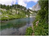 42
42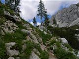 43
43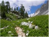 44
44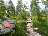 45
45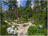 46
46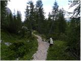 47
47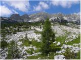 48
48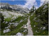 49
49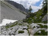 50
50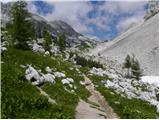 51
51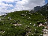 52
52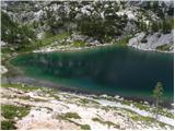 53
53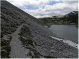 54
54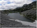 55
55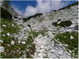 56
56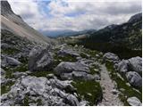 57
57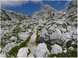 58
58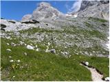 59
59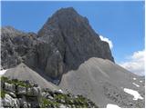 60
60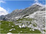 61
61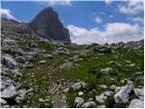 62
62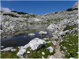 63
63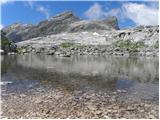 64
64
Discussion about the trip Koča pri Savici - Lake Zeleno jezero
|
| velkavrh25. 07. 2009 |
I was here yesterday when I went through the Valley of Triglav Lakes. The lake is somehow second to last in size. Smaller is only Rjavo jezero under the hut on Prehodavci. Hikers stop here the least. They go past it almost without noticing. Another tip to the caretakers of the Valley of Triglav Lakes. It would be necessary to put up information boards by the lakes. I don't know why they removed it from Dvojno jezero to the hut at Triglav Lakes. I interact a lot with hikers and they miss the information boards!
|
|
|
To post a comment you must log in:
If you do not yet have a username, you must first
register.