Starting point: Lipica (Škibini) (410 m)
| Latitude/Longitude: | 45,65590°N 13,89340°E |
| |
Walking time: 50 min
Difficulty: easy marked way
Elevation gain: 260 m
Elevation difference along the route: 260 m
Map: Primorje in Kras 1:50.000
Recommended equipment (summer):
Recommended equipment (winter):
Views: 32.394
 | 1 person like this post |
Access to starting point:
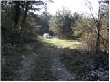
From the highway Ljubljana - Koper we take the exit Divača and follow the road ahead in the direction of the villages Lokev and Lipica. Further, we drive through the village Lokev, behind which we soon come to a crossroads, where the road branches off to the right towards the village Lipica. Only a few meters before the crossroads we notice a narrow road which turns left and after a few dozen meters ends. We turn onto this road and follow it to a smaller parking lot at the end of the road.
Route description:
From a smaller parking lot we continue on a cart track which initially ascends gently through the forest. After a few minutes of walking, the path emerges from the forest onto a somewhat larger clearing, where it crosses a wider cart track. We continue straight on a partly overgrown mountain path, which gradually starts to ascend more and more steeply. After approximately half an hour of walking, we join a wide and well-beaten path, where we continue left in the direction of »Kokoš 15 minutes«. The path ahead for some time crosses the slopes to the left, then gradually starts to ascend. The path, running through the forest, then brings us out of the forest after a short ascent, where we see the mountain hut on Kokoš in front of us.
From the mountain hut we can in a few dozen strides also ascend to the summit, in the middle of which there is a transmitter.
Photos:
 1
1 2
2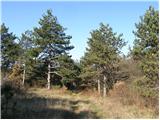 3
3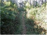 4
4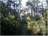 5
5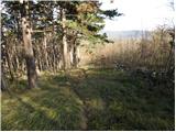 6
6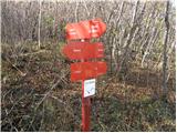 7
7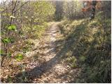 8
8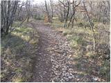 9
9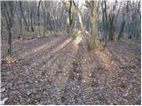 10
10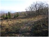 11
11 12
12 13
13
Discussion about the trip Lipica (Škibini) - Kokoš
|
| grantica22. 04. 2011 |
With a colleague we went for a trip to Kokoš via this path 14 days ago. The path is well marked and completely undemanding, at the end a short ascent in the forest which is not demanding because dense forest all the way and nicely cool. We are both recreational hikers and with some breaks needed about 60 minutes.
|
|
|
|
| darh17. 01. 2012 |
On Sunday, as part of a circular trail from in front of Vilenica cave, we climbed to Kokoš via this path and then continued towards Veliko Gradišče, from where there is a really nice view. The trail is really well marked, in fact this applies to the entire circular route we did. Some more impressions from the trip.
|
|
|
|
| rogi17. 01. 2012 |
darh, how long does this circular tour take. Namely, in November we plan with the group, about 40 hikers, to walk this trail.
Thanks for the answer and best regards Igor
|
|
|
|
| Karletto18. 01. 2012 |
That part from Vilenica to Lipica takes about 1.5h. Then Lipica-Kokoš = 45min, Kokoš-Veliko Gradišče = max. 45min + return to Lokev... the whole loop takes at least 3 hours.  Let's see how much I'm off. Let's see how much I'm off.
|
|
|
|
| bruny18. 01. 2012 |
You moderate and ask about times, while @ darh has already provided you with a map full of data - GPS at the end... Excellent tour description as always on the personal blog and exemplary example of how a tour should be written. Congratulations.
|
|
|
|
| Karletto19. 01. 2012 |
Oh, bunny... you're full cool.
|
|
|
|
| B222. 01. 2012 |
No, those who traced and marked the path don't know anything... Vilenica (stamp box, KT path MDO Primorsko-Notranjskih PD) - Škibini 1:30 hours (interesting path, mines, caves, karst terrain, nearby Lipica quarry)..., Škibini - Kokoš is 1 hour, Kokoš - Veliko Gradišče (1 hour). Veliko Gradišče - Prelože - Lokev - Vilenica (1:30 hours)... Hey, Karletto the whole loop with moderate walking and sightseeing takes a full five hours! You're a local, be honest and lend a hand when we're working on the hiking paths... Only then give information and tips to others!!!
|
|
|
|
| Karletto25. 04. 2012 |
This trail was apparently maintained last week with high markings, probably also added some steps and more.
I'll go check it out sometime this week.  
|
|
|
|
| B225. 04. 2012 |
All hiking trails to Kokoš were newly marked last summer... On Saturday, April 21, there was licensed training for path markers on Kokoš, during which we maintained the steep and gentle hiking trail to Kokoš, and the hiking trail past the watchtower. Drainages and erosion protections have been arranged and new steps made up to the hut... Just take a walk Karletto and see our work... We also cut the blackberries along the hiking trail from Škibini to the junction with the gentle trail and cleaned the area around the hut...
|
|
|
|
| bruny27. 04. 2012 |
27.4.2012, together with colleague Vinkot, I hiked a wider circular connection from Lokev between Veliki Gradišč and Starim Taborom and additionally Krvavi Potok and Povir for an even broader view of the area...
Route:Veliko Gradišće - Stari Tabor, 27.04.2012
Regards bruny
|
|
|
To post a comment you must log in:
If you do not yet have a username, you must first
register.