Ljubelj - Koča na Ljubelju
Starting point: Ljubelj (1058 m)
| Latitude/Longitude: | 46,43240°N 14,26020°E |
| |
Walking time: 45 min
Difficulty: easy marked way
Elevation gain: 312 m
Elevation difference along the route: 312 m
Map: Karavanke - osrednji del 1:50.000
Recommended equipment (summer):
Recommended equipment (winter):
Views: 175.198
 | 7 people like this post |
Access to starting point:
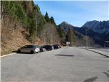
We leave the Gorenjska motorway at the Podtabor junction, and then we continue driving towards Tržič and Celovec. When we arrive at Ljubelj, before the tunnel we turn right onto a larger asphalted parking lot, where we park.
Route description:
At the end of the parking lot, right before the former border crossing, we will notice on the right side the beginning of the footpath and next to it hiking signposts, which direct us to the already mentioned footpath. After a short ascent, we step onto a macadam road (road which leads to the former border crossing on the mountain pass Ljubelj 1369 m) and follow it to the right. The road, which is moderately ascending, first leads us through the forest and then passes to occasionally quite panoramic slopes, from which a nice view opens up on the nearby Košutica and beginning or end of the longest Slovenian ridge Košuta. After a few hairpin turns, the road for the last time turns sharply to the left, and after a few minutes of additional walking brings us to the Koča na Ljubelju mountain hut.

The trip can be extended to the following destinations: Žerjavov Praprotnik / Loibler Prapotnik,
Polna peč ( 30 min),
Dom na Zelenici (2 h 5 min),
Planina Korošica,
Hajnževo sedlo,
Vrh Ljubeljščice (Triangel) (1 h 45 min),
Hajnžev Praprotnik / Zeller Prapotnik,
Lokovnikov Grintovec / Grintoutz (2 h),
Ferlacher Horn / Grlovec,
Loibler Baba/Košutica (2 h),
Veliki vrh (Košuta)
Photos:
 1
1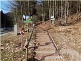 2
2 3
3 4
4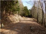 5
5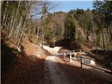 6
6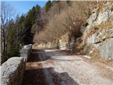 7
7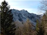 8
8 9
9 10
10 11
11 12
12 13
13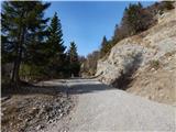 14
14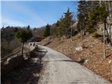 15
15 16
16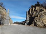 17
17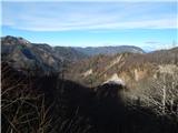 18
18
Discussion about the trip Ljubelj - Koča na Ljubelju
Show older messages
|
| Gost9. 10. 2007 |
Today I was at this hut and continued to Polna peč (1503m). The trail takes another half hour, is easy and although not marked, you can hardly get lost. Polna peč is almost exactly above the tunnel, the view from it is, of course, great. Otherwise I can't find any info about this peak anywhere.
|
|
|
|
| Gost10. 10. 2007 |
I think it's Povna peč (not as "filled" and not as peč, but shortened from "pečina"). Otherwise, really recommended extension of the path, with a beautiful view.
|
|
|
|
| Gost10. 10. 2007 |
It's true, thanks. It said Povna peč, but I subconsciously renamed it.
|
|
|
|
| karlin12. 02. 2010 |
Has anyone been to Ljubelj recently by chance - is there a lot of snow, can you sledge, is there a groomed track?
Thanks!
|
|
|
|
| andrejjerina12. 02. 2010 |
On today's return from Zg.Plota (hope I wrote it right) or Triangla, I noticed sledders who were returning from the road to Ljubelj. Sleds are also rented at Gostišče Koren for 6€/day. Best, Andrej
|
|
|
|
| kris27. 03. 2010 |
I'm interested in the path to the hut, is there a lot of snow
|
|
|
|
| Bojan_A29. 11. 2010 |
Does anyone know how it will be with sledding after the road to the saddle is asphalted?
|
|
|
|
| robter29. 11. 2010 |
Where did you get this idea that there will be asphalt there? Are you kidding?
|
|
|
|
| Gorazd G30. 11. 2010 |
Bojan probably meant the asphalt of the platform in front of the tunnel. At least I hope so ... 
|
|
|
|
| turbo30. 11. 2010 |
I don't know how it will be with sledding after the asphalt. But I can guess that they might even extend asphalt to Zelenica  since machinery is already there since machinery is already there 
|
|
|
|
| bagi30. 11. 2010 |
They are only asphaling the plateau where the former border facilities were. There will be no asphalt on the old Ljubelj pass.
|
|
|
|
| robter2. 12. 2010 |
I also think there can't be asphalt. Probably it's a protected mountain area.
|
|
|
|
| pelican28. 01. 2011 |
Are there conditions for sledding? Anyone know?
|
|
|
|
| @rekar28. 01. 2011 |
I haven't been to the old Ljubelj, but I think not, because there's no snow on the plateau.
|
|
|
|
| Hribovc8828. 01. 2011 |
Hi rekar, are you perhaps that rekar from "ta zgornga Voma", where you have a tourist farm? 
|
|
|
|
| Kriška28. 01. 2011 |
No, currently no sledding conditions, the road is dry below, up top patches of ice in places and traces of snow slab avalanche in a couple spots, otherwise dry.
|
|
|
|
| @rekar28. 01. 2011 |
Hribovc88
No, but I did it easily
|
|
|
|
| peterp18. 02. 2011 |
Does anyone know what the sledging conditions are like after the last snowfall?
|
|
|
|
| @rekar18. 02. 2011 |
About 25 cm of snow fell. Today it was sunny and the wind probably took it all away, I think there won't be anything for sledging
|
|
|
|
| m.b.29. 05. 2011 |
Koča na Ljubelju is open on weekends and they have super strudel..... service was top-notch and we'll come again.... THANK YOU, we had a nice time in your company
|
|
|
|
| skalar5028. 10. 2011 |
The snow has melted, except on three or four spots with a little slush. But across the road there are quite a few fallen trees (obviously the last storm).
On the descent, a little above the parking lot, I saw a sign "passage prohibited" due to forestry works.
|
|
|
|
| ljubitelj gora28. 10. 2011 |
The path to the hut is impassable, because they are working there, timber hauling, passage prohibited, crosses the ski slope 2-3 times.
|
|
|
|
| Lavendel1. 12. 2013 |
The path to the hut is not plowed, but it's a nice little path all the way to the hut. In it, however, [there is a] warm, pleasant atmosphere and good food.
|
|
|
|
| skalar505. 08. 2014 |
maybe it would be worth replacing the hut photo, which after ownership change (Celje lawyer) is outwardly completely "tagmašno renovated" ....
how much the new content will please old Ljubelj fans is another question ...
|
|
|
|
| kurirček19. 10. 2014 |
It's sad that a foreigner has to show how to take care of the hut and work in such a hut.
The former owner just watched how to earn as much as possible in the easiest way.
He took everything he had installed so far with the devil.
|
|
|
|
| sirt120. 10. 2014 |
Why foreigner? He is a Slovene who still lives in the former common country and hasn't learned the thieving ways of the other (JeBeTe) common country!
|
|
|
|
| mgrego2229. 11. 2014 |
I'm wondering if there will be any provision or organization for sledding from the old Ljubelj this year. The new owner could do something about it. A few years ago it was really great. We rented sleds at a reasonable price and it was a real experience. It could be arranged for this tradition to continue.
|
|
|
|
| tinky30. 11. 2014 |
The caretaker is the same as before, only the owner is different.
|
|
|
|
| andrej.bg1. 12. 2014 |
I was at this hut two years ago, when there was some border meeting, a larger group was singing in German, but the atmosphere was pleasant and I didn't feel threatened.
This year with my family I visited Tromeja and also Dreiländereckhütte right on the Austrian side. Despite the proximity of the border and visitors from Slovenia, the menu in German and Italian, but no one from the staff spoke a word of Slovenian, hardly a few words in English.. It seems to me the message is unequivocal.
|
|
|
|
| strelec19541. 12. 2014 |
Some will agree with me, others will say I'm stingy, but my opinion is that I have a backpack in the mountains to carry everything I need for the mountains, including food and drink.
The only hut I visit is Kredarica in winter time where I'm always well served and the prices aren't exaggerated given the winter conditions.
Otherwise, no hut is as nice as munching something good outside in nature, after lunch you can even lie down a bit without worrying about disturbing anyone.
|
|
|
|
| smatjaz1. 12. 2014 |
Shooter, you're right in your own way and I understand you, but if everyone thought like that, all the huts would go bankrupt and close, some of us do depend on the huts, especially if we're going on a multi-day tour and need them, we also meet acquaintances there and make new contacts and acquaintances, and gather information, of course it's possible without it, but it's not as interesting, and in the end, when my son and I wandered around the western part of the Julians for 8 days this summer, I don't know how we would have managed without the huts where you sleep, recharge your strength, eat something warm, and at least wash minimally, not to mention toilet needs, have you ever thought about it that way. On day hikes, it has happened to me too that I just passed the hut with a greeting.
|
|
|
|
| sara..3. 01. 2015 |
Does anyone know what the current conditions are on the sledding path? Is the snow packed? Thanks!
|
|
|
|
| RadoPres3. 01. 2015 |
Yesterday's info. Excellent, groomed but unlike those down here friends (up there) had sun - recommend :)
|
|
|
|
| panda3. 07. 2015 |
Is it possible to drive up by car?
|
|
|
|
| dare293. 07. 2015 |
Possible, but not allowed.
|
|
|
|
| VanSims3. 07. 2015 |
From our side the road is also physically closed, from Austrian side it is open (still prohibited) but quite rough and unpleasant (I only pushed the bike so I had it right at hand when I finished crossing Košuta )
|
|
|
|
| panda3. 07. 2015 |
I know about the Austrian side that it's a shame for the car.....a few years ago it was maintained....
|
|
|
|
| @rekar4. 07. 2015 |
The road to Ljubelj is physically closed from our side, from Austrian side there is a "no traffic" sign because it is private property, I don't recommend driving as you can meet Austrian police and they fine you.
|
|
|
|
| panda5. 07. 2015 |
I found out on Saturday (right at the tunnel physical road closure), returning from Vrtače to the parking lot. I used the footpath and also visited the hut at the old pass. Great......drank a beer and back, Saturday complete.
|
|
|
|
| plejade4510. 08. 2015 |
Pleasant and nicely kept hut, friendly staff, legendary mushroom soup. Recommended.
|
|
|
|
| radagremvhribe11. 08. 2015 |
The hut is closed on Tuesdays, on the way to the viewpoint or full walk, met the caretaker who marked the path with a nice red signpost, very friendly and hardworking, on the way back met him again, he was helping workers with road repair
|
|
|
|
| bantaia9. 01. 2016 |
Today we were up, in slush and fog, but no problem In the hut super, great atmosphere, the host also praiseworthy We'll surely come once to see the view and for sledding, and for some Košutnik too
|
|
|
|
| Barentoter4. 06. 2017 |
Today I returned from Košutica over the ridge to the hut at Ljubelj. Here I treated myself to a beer and ričet, and I almost had a stroke when I paid 8 euros for ričet with half a sausage. Usually I have some sandwich in my backpack, this time unfortunately not. I'm curious what the usual prices for ričet in huts are.
|
|
|
|
| Daaam5. 06. 2017 |
old trick stew with meat means of course you get a couple of pieces of meat in the stew. It has happened that someone asked if I'd rather have meat or half sausage with the stew.. of course I chose sausage until I got a bill with one item stew and another half sausage - total naturally higher than stew with meat well once or twice they tricked me a bit.. now I almost never eat in huts anymore, except in proven good ones
|
|
|
|
| francimedved29. 05. 2020 |
On Wednesday we were up there, a small group of (30) retirees, very nice weather, excellent service and even better food. I recommend.
|
|
|
|
| golica27. 12. 2025 09:14:09 |
Tomorrow we're heading up here and would like to extend to Povna peč. Since the trail is snowy, I'm wondering if there's any risk of slipping all the way to the top, or how "easy" it is. Thanks.
|
|
|
|
| capraibex27. 12. 2025 20:48:43 |
The last section is demanding in winter conditions, i.e. dangerous for slipping.
|
|
|
To post a comment you must log in:
If you do not yet have a username, you must first
register.