Starting point: Lontovž (950 m)
| Latitude/Longitude: | 46,09460°N 15,06310°E |
| |
Route name: footpath
Walking time: 40 min
Difficulty: easy marked way
Elevation gain: 270 m
Elevation difference along the route: 270 m
Map:
Recommended equipment (summer):
Recommended equipment (winter):
Views: 86.511
 | 3 people like this post |
Access to starting point:
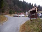
At the traffic light just a little before Trbovlje, if we are driving from the Ljubljana direction, we turn right in the direction of Kum. And if we come from Trbovlje, immediately after Trbovlje at the traffic light we turn left towards Kum. We follow the road, which is steeply ascending, through the village Dobovec to Lontovž, where we park on the parking lot.
Route description:
From the parking lot, we continue ahead on an asphalt road which goes into the forest. After a good 10 minutes of walking, the footpath branches off to the right towards Kum.
We go on this path, which through the forest in a gentle ascent after 20 minutes brings us back to the road. When we come to the road, we go right and follow it a few meters to a meadow, where we go right. The path goes at first along the edge of the meadow, then for a few meters into the forest. After that we come to the upper grassy slopes of Kum. Here we go towards the chapel, which we see in front of us. Immediately after the chapel we come to the road which we follow to the summit, to which we only have a few meters.
Photos:
 1
1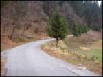 2
2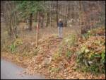 3
3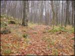 4
4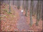 5
5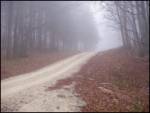 6
6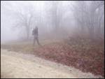 7
7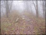 8
8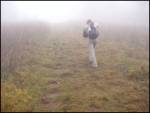 9
9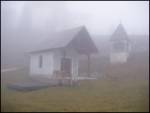 10
10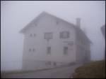 11
11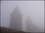 12
12
Discussion about the trip Lontovž - Kum (footpath)
|
| majdicst13. 02. 2007 |
I suggest another path: at Dobovec park at the hunting hut and then go through the forest and along the road to "Srečkova rajda" - the last sharp double bend before Lontovž, there turn left towards Ključevci and go for a while along the road. Soon you can turn right across the meadows directly to Kum, or continue to the church of St. Mary and turn right there towards Kum. A little below the summit you join the path coming from Radeče (Zidani Most). A bit longer path, but much nicer than the one from Lontovž.
|
|
|
|
| Gost13. 02. 2007 |
I'm glad for such information, which I save and realize when the opportunity arises. "majdicst", can you tell me if it's a marked path? If not, is there a visible trail, cart track?
Thanks and best regards. Ljubica
|
|
|
|
| majdicst14. 02. 2007 |
Well, here's how it is with this route: from the hunting hut at Dobovec, as far as I remember, the path is marked, but actually only the first part leads along a well-visible trail through the forest, then you just go along the road. Also from the so-called "Srečkova rajda" you continue along the road - you really can't miss the junction to Kljuževca - the only junction to the left from the main road, and it's marked. You walk along the road to the church, where you leave the road (there is a shortcut through the forest, but it's not marked, so it's quite hard to find) - from here you continue along a well-visible trail (the only one leading uphill), past the sexton's house and weekend cottage, cross the ridge, descend slightly downhill and for a while continue again along the road through a small hamlet, then the path turns quite steeply uphill towards Kum. The path is well visible all the time, as far as I remember, it's also marked (but not continuously), so you almost can't miss it.
I don't recommend the direct path soon after the junction from the main road across the meadows, unless you're with someone who knows the terrain at least a little. Although in the end all uphill paths lead to the top sooner or later.
I forgot to mention the fantastic view from the top of Kum, which unfortunately can't be seen in photos. 
Some additional information and descriptions (although for another route) and a map can be found here: http://www.zaplana.net/Izleti/Kum/index.asp?sect=3&pfx=ZM
|
|
|
|
| mana6517. 08. 2010 |
Personally, the hiking path starting from Podkum suited me better, all the time nicely along the forest path, summer heat doesn't get to you so much, you never encounter the road. The only slightly awkward thing is that you don't know where to leave the car in the village so they wouldn't consider you inconsiderate. I don't know how it is on crowded days, but during the week you have a bit more choice... nice excursion point, wonderful view all around...
|
|
|
|
| hribuc8518. 08. 2010 |
Hi mana65!
Something interests me. I know those ends on the Dolenjska side of Kum quite well, but from Podkum I don't know the path to avoid the road from Podkum to Mali Kum. Do you mean the village Mali Kum (just above the village you go into the forest and start steep ascent) or does a path from Podkum (not on the road) to Kum exist. I would ask you if in this case you tell me where it starts and if it's marked.
Thanks.
Good luck.
|
|
|
|
| mana6521. 08. 2010 |
That's how it is as you think, I'm not exactly from those parts, but this path was known to me from school days, of course you drive to the Podkum sign and then to the end of the asphalt, no I'm not such an expert to discover new paths, of course it's all just a comment - impression....
|
|
|
|
| Pohodnica5624. 01. 2011 |
Yesterday was another beautiful day and since on Sundays I choose slightly shorter paths, I "jumped" to Krim. Fantastic views. I parked quite a bit lower than Lontovž, approximately at 700 m altitude. On the road it's a bit annoying because of the cars rushing to Sunday lunch (serves me right, I should have taken another path). I have to criticize the hut caretakers a bit. They could clear the snow from that front terrace. It would be nice to sit a bit in the shelter (especially for us exhausted ones, we're to blame ourselves, right ), but the chairs and tables are scattered like after a bora, full of snow that fell from the roof. ), but the chairs and tables are scattered like after a bora, full of snow that fell from the roof.
|
|
|
|
| hribuc8524. 01. 2011 |
Hi!
Pohodnica56, you probably "jumped" to Kum and not to Krim. I know it's a minor mistake, just so no one looks for Lontovž under Krim. Yesterday was really a beautiful day for going a bit higher, yes, but I'm also not satisfied with the caretaker at Kum. That's how it is.
Good luck!
|
|
|
|
| Kokta8. 01. 2012 |
Beautiful sunny day and magnificent view from the top. Highly recommend a visit. The trail is icy in the last 200m of elevation gain, so crampons or slide down the snow beside the trail.
|
|
|
|
| Kokta8. 01. 2012 |
Beautiful sunny day and magnificent view from the top. Highly recommend a visit. The trail is icy in the last 200m of elevation gain, so crampons or slide down the snow beside the trail.
|
|
|
|
| ZOJA16. 03. 2012 |
hello everyone,
can someone describe the path to Kum from Podkum and how long it takes to the top.
lp
|
|
|
|
| Holcar216. 03. 2013 |
Today on Kum, wonderful weather. Snow about 20-30 cm, perfect powder, heavily windblown, sometimes down to old icy base, several small slides. Down in the valley everything bare and little suggests real winter presence 1000 meters higher. Temperatures mostly below zero all day, afternoon maybe around zero, in valley 6 degrees. Almost no snow on summit except large cornices. If going over summit meadows (where they also ski) recommend small crampons due to old, somewhat southern snow turned to ice. Tackle the trip tomorrow, later no more real winter!
|
|
|
|
| barabica21. 02. 2018 |
What's the road like to the starting point?
|
|
|
|
| nejcf6. 07. 2020 |
Yesterday we happened to be in this part of Slovenia, so we decided on a quick trip from Lontovž to Kum. There were quite a few people, probably also because PD Kum Trbovlje was celebrating 70 years of its existence in the hut. Nice, but really a very short trip.
|
|
|
To post a comment you must log in:
If you do not yet have a username, you must first
register.