Mače - Zavetišče v Hudičevem borštu (Mačenska pot)
Starting point: Mače (586 m)
| Latitude/Longitude: | 46,31310°N 14,41870°E |
| |
Route name: Mačenska pot
Walking time: 1 h 55 min
Difficulty: easy marked way
Elevation gain: 742 m
Elevation difference along the route: 742 m
Map: Karavanke - osrednji del 1:50.000
Recommended equipment (summer):
Recommended equipment (winter): ice axe, crampons
Views: 59.024
 | 4 people like this post |
Access to starting point:
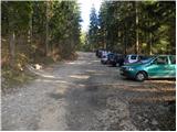
a) From the Ljubljana-Jesenice motorway, take the Kranj-east exit, then continue driving towards Jezersko. When arriving in Preddvor, leave the main road and continue left towards the centre of the mentioned place, from there follow the signs for Mače. When arriving in Mače, at the marked junction continue right (left Bašelj, straight church of St. Nicholas (church not accessible by car)) and drive up the narrow road above the village, where there is a large marked parking lot.
b) From the Jesenice-Ljubljana motorway, take the Kranj-west exit and at the first junction continue left. Continue driving through the underpass under the motorway, then arrive at a roundabout, from which continue driving towards Golnik. The route ahead leads through the settlement of Mlaka pri Kranju, we, at the end of the settlement, continue right towards the settlement of Srakovlje. Follows driving through Srakovlje, Spodnja Bela, Srednja Bela to Zgornja Bela, where continue right towards Preddvor. In Preddvor notice signs for Mače, which direct left past the primary school to the road that climbs to Mače. When arriving in Mače, at the marked junction continue right (left Bašelj, straight church of St. Nicholas (church not accessible by car)) and drive up the narrow road above the village, where there is a large marked parking lot.
Route description:
At the start of the large parking lot above Mače, notice the mountaineering direction signs, continue right across the entire parking lot towards the Shelter in Hudičev boršt, Javorov or Javorjev vrh, Potoška gora and St. Jakob. From the end of the parking lot, a marked cart track continues, which we follow. The cart track, which has some minor junctions in the lower section where we follow the markings, initially ascends gently to moderately, then somewhat steeper for a short time. After crossing the torrent, the cart track gradually levels out and leads us to a marked junction, where the mountaineering signs direct us left onto a well-trodden and well-maintained mountaineering path. The marked path immediately enters fairly dense forest, through which it ascends for a while along the torrent gully, then turns somewhat more to the right and leads us in a few zigzags to a less noticeable junction, where the path to Dom na Kališču branches left (the branch is marked with an inscription on a tree), we continue straight along the path that gradually leads us into sparser forest. Higher up, the increasingly sparse forest ends and the path leads us to panoramic grassy slopes, from which a nice view of Gorenjska opens up. Follows another good 10 minutes of ascent along the mentioned grassy slope and we arrive at the spring in Hudičev boršt, beside which there is a marked junction.
Continue right again (left Dom na Kališču, Dolga njiva, Srednji vrh...) and after one or two minutes of further walking arrive at the Shelter in Hudičev boršt.

Along the route: Izvir v Hudičevem borštu (1328m)
Photos:
 1
1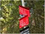 2
2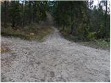 3
3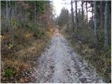 4
4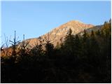 5
5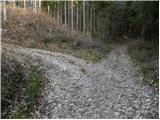 6
6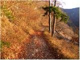 7
7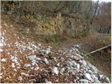 8
8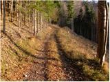 9
9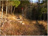 10
10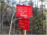 11
11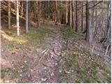 12
12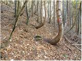 13
13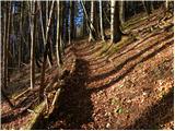 14
14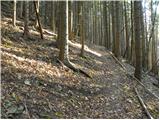 15
15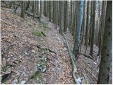 16
16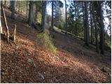 17
17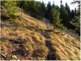 18
18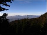 19
19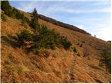 20
20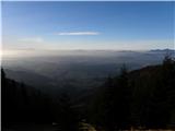 21
21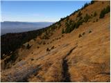 22
22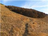 23
23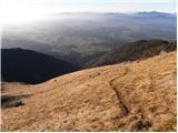 24
24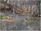 25
25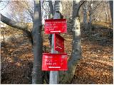 26
26 27
27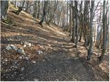 28
28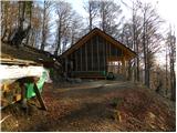 29
29
Discussion about the trip Mače - Zavetišče v Hudičevem borštu (Mačenska pot)
|
| Tajda21. 03. 2015 |
Paradise on earth!!! 
|
|
|
|
| Kranj22. 03. 2015 |
It really is paradise and a nice shelter, do you go to the devil's several times???
|
|
|
|
| lucylucy9. 06. 2015 |
Hi,
I also liked this hiking tour. The whole time you're walking in the shade, and when you come out of the forest, a fantastic view of the valley opens up. The path itself is easy. The hut keepers are also very friendly, so we'll come again. It's really a paradise.
|
|
|
|
| KARAMELICA26. 12. 2015 |
Last Sunday my husband and I decided to visit the shelter in Hudičev boršt. I can't help but mention that the path is excellently marked. Markings are at every junction, practically every bend is marked. Super, full marks. Praise also to the friendly caretaker we chatted with at the top. For the return he suggested a circular route, which we did. The return path is also excellently marked. As for the view......fantastic. Really, paradise on earth. Recommended. Praise also to the friendly caretaker we chatted with at the top. For the return he suggested a circular route, which we did. The return path is also excellently marked. As for the view......fantastic. Really, paradise on earth. Recommended.
|
|
|
|
| gmirko31. 12. 2015 |
It's really nice, but from photo 3 to 10 the path is completely renovated, almost a forest highway.
|
|
|
|
| Kranj1. 01. 2016 |
Clearing timber after the ice storm, so there will be more and larger and wider roads Otherwise you can go some other way to the devil's place where there is no HIGHWAY. Happy 2016 Otherwise you can go some other way to the devil's place where there is no HIGHWAY. Happy 2016
|
|
|
|
| tango26. 02. 2019 |
Today from Mače to the shelter in Hudičevem borštu and further to Jakoba and via Juhantovi to Potoče, then along the traverse back to Mače. Conditions good, path super, a bit of wind on the ridge above Kokro and from the junction to Javorjev vrh onwards to Jakob locally quite icy. But no panic.
|
|
|
|
| Pekana16. 03. 2020 |
Hey, you're not crazy, I know where those paths are! Our dear one in the morning, let's go to Hudičev boršt today, well, oh devil, really!? We meet at the parking in Mače, I already made a mistake as soon as I got out of the car. I congratulated her birthday a day earlier... you know, I really don't know what I see in you, you see what confuses everyone else! ☺. Dressed though....partner, windbreaker, cap, shorts, ready! In the backpack Bajadero. On top of that I forgot water, our dear one started getting angry as I imagine it, that I would dehydrate... well... I woke up dehydrated, since I drank it the night before, twice with teeth! ☺ Then she picked berries along the way, this and that, whatever wasn't, I just raised the pace, only there I quieted her chatter. There might be some snow patches on the road, and muddy grass quite a way from the dew, well... the cows have horns... but no cattle seen, probably they are in quarantine too ☺. People though some go lazily, there was an older lady coming down, coughing and really farting and stuffing tissues under that red kumara. We just went around her with Majdi 7 meters, just so we didn't end up in the same grave digging a career. Well Majdi today doesn't greet anyone, says SARS flies in the air too, not just paragliders. We arrive at the top, like an old man couldn't take off with paraglider, they fiddle with those strings for hours before, well even if he flies the cart he'll fly in 100 years. Oh we laughed, the sun warmed our already quite warm souls. Then I look left and see the top of Koren again, I almost closed my eyes. Otherwise nice, uuuuu, our dear, grass smells just like autumn, well there will be no summer. ☺ I was so thirsty that I licked the trees. Well then we sit down in the shelter at Gorla, and our dear pulls out a meter-long bottle of schnapps from the backpack, two hours from the bottle to Monday, since Sunday is a holiday ☺ Well, why do you carry such schnapps yourself? Says for you! I disappointed her though, since I couldn't drink, not that I didn't want to. Our dear had her 4th anniversary that day she had to break, well, that's what I thought when I wanted to congratulate. ☺ I tried halfway to fly in, but no real hustle. Otherwise the hut up there closed, only one puzzle in the hut's entrance was open, like for some party said Majdi. Well, we put the bottle diagonally back into the backpack and off we go to wander the meadow a bit more... and suddenly I shout Marija, Marija sedmica! And I find running spring water and faucet, I drink like a camel! Still hiccuping and giggling, the sun has set and slowly down into the dark. The conversation flowed, and we walked! Our dear says, should we turn on the lights up... well lights are for pussies, and I ask her if she's seen a chamois with a light, says you've got proof! We arrive at the car still talking carefree, hehehe, well you understand that when you work at the bank. Then she drives behind me and I see her front light doesn't work, stops at the gas station, buys a bulb and action. I fuck with that bulb for a while since we're going up, I say turn on the car to see, but I swapped the wrong bulb, the one that was working, she says you know Petr you're such a fool! It'll be fine!
I tell you, even in devil's forest the devil didn't take us for a ride!
|
|
|
|
| Pekana18. 03. 2020 |
Come on, man, you're crazy, I know where those paths are! Our dear in the morning, let's go to Hudičev boršt today, come on man, oh devil, really!? We meet at the parking in Mače, I already made a mistake as soon as I got out of the car. I congratulated her birthday one day before... you know, I really don't know what I see in you, come on man, you see what confuses everyone else! Our dear in the morning, let's go to Hudičev boršt today, come on man, oh devil, really!? We meet at the parking in Mače, I already made a mistake as soon as I got out of the car. I congratulated her birthday one day before... you know, I really don't know what I see in you, come on man, you see what confuses everyone else!  Dressed in tracksuit, windbreaker, cap, shorts, ready! In the backpack Bajadero. On top of that I forgot water, our dear started angrily rattling, as I imagine it, and that I'll dehydrate... come on man... I woke up already dehydrated, since I drank it the previous evening, twice as much needed! Then she collected it along the way, this and that, whatever I don't have, I just raised the pace, only there I quieted her nagging. Dressed in tracksuit, windbreaker, cap, shorts, ready! In the backpack Bajadero. On top of that I forgot water, our dear started angrily rattling, as I imagine it, and that I'll dehydrate... come on man... I woke up already dehydrated, since I drank it the previous evening, twice as much needed! Then she collected it along the way, this and that, whatever I don't have, I just raised the pace, only there I quieted her nagging.
Along the trail there might be some snow patch, and on the grass slippery enough from dew, well... those goats sharpen horns... but no animals seen, probably they are in quarantine too . People some walking briskly, there was an older lady down, coughing and really steaming and stuffing tissues under that red Fiat. We just went around her with Majda 7 meters, just so we don't end up locked in the same ravine and end our career. Come on man Majda today doesn't greet anyone, they say that SARS flies through the air too, not just paragliders. We arrive at the top, as one old guy couldn't take off with paraglider, they fiddle with those strings for hours beforehand, come on man if he flies now he's been flying for 100 years.
We laughed, the sun warmed our already quite warm souls. And looking left I see the top of Koren again, I just blinked. Otherwise nice, uuuuu, our dear, grass smells just like autumn, come on man there won't be summer. I was so thirsty that I licked sap from trees. Well then down we sit in the shelter, and our dear pulls out a meter-long bottle of schnapps from the backpack, the clock from the bottle to Monday, since Sunday was felt. Come on man, what are you carrying so much schnapps for? She says because of you! I disappointed her though, if I couldn't drink, not that I wasn't thirsty. She had her 4th anniversary when she broke her leg, well come on man, that's what I thought when I congratulated her. I tried halfway to fly into it, but no real smoke. Otherwise the hut at the top closed, only one puzzle in the hut's vestibule was open, as if for some party said Majda. No, we put the bottle diagonally back into the backpack and still halfway fainted on the meadow... and suddenly I call Marijaaa, Marijaaa seventh! And I find flowing spring water and tap, I drink like a camel! Still a bit dizzy and giggling, the sun set and we slowly went down into the dark.
The conversation flowed, and we walked! Our dear says, shall we turn on the lights up... come on lights are for pussies, and I ask her if she's seen a chamois with a light, she says you've got proof! We arrive at the car still chatting carefree, hehehe, come on man you understand that as you work in a bank. Then drive behind me and I see her front light doesn't work, stop at the gas station, buy a bulb and action. I mess with that bulb for a while as we were walking up, I said come on start the car to see, but I swapped the wrong bulb, the one that was working, she said you know Petr that's so typical! It'll be fine!
I tell you, even in Hudičev boršt the devil didn't take jokes from us!
|
|
|
|
| Pekana18. 03. 2020 |
Here's what I have to say, as I'm really like that, I forgot under the car on Sunday 15.3 hiking shoes for climbing hills, and even with them I sang... still quite good and I went to look for them after 3 days and the honest finder hung them on a branch and taped them with blue tape so the wind wouldn't carry them away. Wow respect!!! Thanks again and hope this guy reads it sometime. If he contacts me in inbox, I'll take him for a drink or to the top of Koren )) Thanks really, once more!!!
|
|
|
|
| mirank18. 03. 2020 |
Google translate doesn't handle Moldavian; translation please
|
|
|
|
| julya18. 03. 2020 |
This is really a nice "little path"!
|
|
|
|
| Pekana19. 03. 2020 |
Go to Kišnjev, there they'll translate it for you
|
|
|
|
| piotr21. 03. 2020 |
Kišinjev
|
|
|
|
| tango23. 04. 2023 10:13:36 |
A bit for fitness, up and down, at the shelter/hut a team of paragliders who launched around four in the afternoon, excellent flying conditions, apparently according to a layman's opinion. Lively in the hut, magnificent view. The path is completely dry, really excellent so it's worth loosening the bones a bit. The team with rakes returning was excellently spirited and we immediately agreed they were raking the ski slope so skiers wouldn't complain
|
|
|
|
| 1muha13. 08. 2023 20:06:58 |
Is the path normally passable? Regards.
|
|
|
|
| hočo13. 08. 2023 23:30:59 |
|
|
|
To post a comment you must log in:
If you do not yet have a username, you must first
register.