Mangartsko sedlo - Mangart (Slovenian way)
Starting point: Mangartsko sedlo (2055 m)
| Latitude/Longitude: | 46,44370°N 13,64160°E |
| |
Route name: Slovenian way
Walking time: 2 h
Difficulty: very difficult marked way
Via ferrata: B
Elevation gain: 624 m
Elevation difference along the route: 624 m
Map: Julijske Alpe - zahodni del 1.50.000
Recommended equipment (summer): helmet, self belay set
Recommended equipment (winter): helmet, self belay set, ice axe, crampons
Views: 414.297
 | 15 people like this post |
Access to starting point:
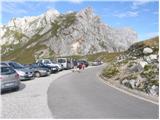
a) First we drive to Kranjska Gora, then continue driving through the Rateče border crossing into Italy. We drive towards Trbiž / Tarvisio, then at the beginning of the mentioned town we turn left in the direction of Bovec. We continue along the regional road towards the Predel border crossing, but we turn left just a little after the mentioned border crossing (that is, when we are already on the Slovenian side) in the direction of Mangartsko sedlo. We continue along the occasionally narrow and serpentine road (the road also has several tunnels), and we drive along it to Mangartsko sedlo, where we park in the parking lot at 2050 meters above sea level. The road is a toll road.
b) First we drive to Bovec, then continue driving towards the Predel border crossing. Just a few 100 m before the mentioned border crossing, more precisely after the large arched bridge, we turn right in the direction of Mangartsko sedlo. We continue along the occasionally narrow and serpentine road (the road also has several tunnels), and we drive along it to Mangartsko sedlo, where we park in the parking lot at 2050 meters above sea level. The road is a toll road.
Route description:
From the parking lot we first walk to Mangartsko sedlo, from where we continue right towards the east and continue the trail along the scenic grassy ridge. After a few minutes of easy walking the path becomes somewhat steeper and bypasses the nearby Travnik (2200 m) on the right southern side. From there onwards the path becomes even steeper, and after approximately 30 minutes of walking from the starting point it brings us to a junction where the path splits into two parts; left the Italian and right the Slovenian path.
We continue on the right Slovenian path, which in a slight descent crosses the nearby scree and brings us to the beginning of the climbing part of the path.
Here we put on a helmet due to the danger of falling rocks.
The path ahead immediately ascends steeply, and during the ascent we are helped by pitons and steel cables. Higher up the path temporarily levels out and transitions onto an artificial ledge, after which we cross a gully exposed to falling rocks (this part of the path is well secured). On the other side of the gully the path continues to ascend steeply, and on the more difficult sections we also have to help ourselves with our hands. We continue the path along and beside the wide gully straight upwards, during the ascent the path occasionally runs above deep precipices. Higher up the path turns somewhat to the left and gradually becomes less demanding. When we see the cross in front of us, only some 10 easy walking steps separate us from the summit.
We can descend via the somewhat easier Italian path.
Mangartsko sedlo - turnoff to Bivak Nogara 0:15, turnoff to Bivak Nogara - path junction 0:15, path junction - Mangart 1:30.

Along the route: Odcep k Bivaku Nogara (2146m), Razcep poti (2228m), Rama (2531m)
Photos:
 1
1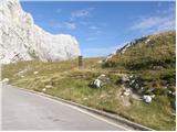 2
2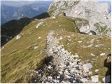 3
3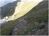 4
4 5
5 6
6 7
7 8
8 9
9 10
10 11
11 12
12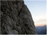 13
13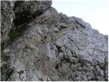 14
14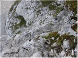 15
15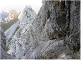 16
16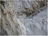 17
17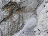 18
18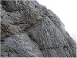 19
19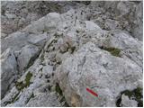 20
20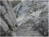 21
21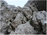 22
22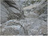 23
23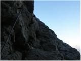 24
24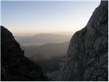 25
25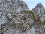 26
26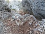 27
27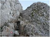 28
28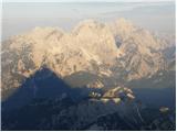 29
29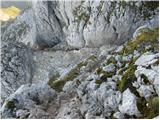 30
30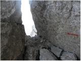 31
31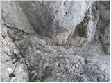 32
32 33
33 34
34 35
35 36
36
Discussion about the trip Mangartsko sedlo - Mangart (Slovenian way)
Show older messages
|
| Gost10. 07. 2006 |
Mangart is such a beautiful and mighty mountain, I recommend the tour right from Belopeških jezer, past the bivouac to the saddle and from there to the top. This way you will experience the mountain in all its grandeur and beauty. Regards Vida
|
|
|
|
| Gost4. 10. 2006 |
I'm just setting off up this path this Friday, so I'm interested if someone can describe the path more precisely. also to mail (majaduh@yahoo.com). REALLY THANKS!!!
|
|
|
|
| Gost4. 10. 2006 |
On Friday the path to Mangart will most likely be snowy. Snow is forecast above 1600m for tomorrow.
|
|
|
|
| Gost4. 10. 2006 |
ooh, yeah really!!! didn't even think of that. Yeah, we'll see what the conditions are like. Thanks for the warning!!
|
|
|
|
| Gost1. 11. 2006 |
The Slovenian route is very beautiful and very demanding, descent only via the Italian one. LP Silvo
|
|
|
|
| majdicst13. 02. 2007 |
The Slovenian one is super! Especially when, as you desperately cling to the peg on one side and the rock on the other and think about how to make the next step, a middle-aged Austrian overtakes you like a chamois, who DOESN'T EVEN USE HER HANDS!!!!! Especially when, as you desperately cling to the peg on one side and the rock on the other and think about how to make the next step, a middle-aged Austrian overtakes you like a chamois, who DOESN'T EVEN USE HER HANDS!!!!!  Joking aside.... not for the vertiginous, but it's really a wonderful ascent with exceptional views. I didn't use the via ferrata set (although I carried it), helmet is mandatory. Definitely advise against descent on this path. Joking aside.... not for the vertiginous, but it's really a wonderful ascent with exceptional views. I didn't use the via ferrata set (although I carried it), helmet is mandatory. Definitely advise against descent on this path.
|
|
|
|
| Gost21. 03. 2007 |
which trail is less demanding

|
|
|
|
| Gost21. 03. 2007 |
Are you kidding, LISTEN TO THE MEDIA AND YOU'LL HEAR WHAT'S HAPPENING ON MANGART!!!!
|
|
|
|
| Gost21. 03. 2007 |
Easier, but still demanding is the Italian one. The Slovenian trail is very demanding. And wait for favorable conditions!
|
|
|
|
| Gost22. 03. 2007 |
I went to Mangart on the Italian up and down, the trail seemed demanding to me at some places otherwise nothing special.
|
|
|
|
| Gost22. 03. 2007 |
I advise going up the Slovenian route, down the Italian one. For both you must be well prepared with harness, helmet and wait for favorable conditions. The most favorable is in summer, when you can start the tour from the Belopeška Lakes, past Bivak Nogara and to the saddle. Magnificent tour, as befits a magnificent mountain like Mangart.
|
|
|
|
| Gost28. 03. 2007 |
Respect every mountain because even one wrong step can be fatal... Take care of yourself, behave responsibly towards yourself and others and the mountain will protect you. Only then will you truly enjoy and remember your achievement as a pleasant experience. Mangart? One of the most beautiful Slovenian mountains. A mountain that loves, but also kills. Therefore it matters how you conquer it!
|
|
|
|
| Gost10. 05. 2007 |
The trail and the whole mountain are awesome!!!!!!!!!!!!
|
|
|
|
| Gost11. 05. 2007 |
this mountain is fateful! 
|
|
|
|
| fpetel130. 05. 2007 |
But VIA ITALJANA ferrata perhaps nicest path to Mangart, not for everyone.
|
|
|
|
| Gost30. 05. 2007 |
Last year I hiked Via Italiana in non-ideal conditions (fog, rain), so I advise against it in wet conditions due to polished holds from boots.
|
|
|
|
| Gost31. 05. 2007 |
Mangart is really a beautiful mountain. That's why I think the word super is not suitable for it at all.
|
|
|
|
| Gost16. 06. 2007 |
I'm wondering if it's suitable to go to Mangart tomorrow, that's 17.6.2007, due to thunderstorms, so please someone answer me regarding the weather?
|
|
|
|
| Gost16. 06. 2007 |
I read that there was a rockfall on the Slovenska smer route, which is therefore closed. And also given the stormy weather, I wouldn't recommend it...
|
|
|
|
| Gost27. 06. 2007 |
The path is wonderful, the hut warden polite and friendly only low clouds obscured the beautiful view for us. Repeat the feat as soon as possible JOŽE R.
|
|
|
|
| alojzijus15. 08. 2007 |
On 14.8. we went up the Slovenian and down the Italian. Start from the saddle - early in the morning. Slovenian after renovation nicely secured, but still a bit crumbly. Nice weather, wonderful view. For less experienced, via ferrata set, helmet mandatory.
|
|
|
|
| Gost15. 08. 2007 |
It's a pity that you all go from Mangart Saddle to the summit. The path from Belopeška Lakes is gorgeous, the mountain itself, so majestic and beautiful as it is, deserves that we put a little more effort into reaching the summit. Really beautiful hike.
|
|
|
|
| alojzijus16. 08. 2007 |
I agree, I just had my daughters aged 12 and 16 with me, and neighbor's son 10 years.
So the hike was intended for younger ones.
|
|
|
|
| Gost16. 08. 2007 |
Can someone explain the path to Mangart from the Belopeška jezera a bit? Where to park the car, what are the main stops on the path... And how many hours does the ascent take; I'd like to be up and down in one day. Is going up without a helmet more risky than on most of our marked trails? Marko
|
|
|
|
| Gost24. 08. 2007 |
Tomorrow I'm heading to Mangart, but is a helmet really necessary? I don't have one myself...
|
|
|
|
| Gost24. 08. 2007 |
The helmet is necessary - after all, it's about your safety. Especially because quite a lot of people go up and someone can accidentally trigger rocks. You can perhaps avoid this if you start walking very early. Otherwise, the Slovenska pot is very well secured. Just use your head and be careful!
|
|
|
|
| Gost24. 08. 2007 |
Tomorrow there's cycling on Mangart, so the road will be closed for a while too
|
|
|
|
| Gost24. 08. 2007 |
You go to the mountains on foot, not by bike.
|
|
|
|
| Gost24. 08. 2007 |
They're not going to Mangart, probably just along the road to the saddle?
|
|
|
|
| Gost25. 08. 2007 |
They're flowing everywhere already, it wouldn't be anything strange.
|
|
|
|
| Gost26. 08. 2007 |
Recently we went to Mangart. We drove to the saddle then to the bivouac and took the DIFFICULT route to Mangart (via ferrata kit and helmet required). You arrive where the Slovenian route starts, so we also did the Slovenian (helmet essential, because it was really crumbly, lucky no one was hit by a big stone that just missed him). Then back down the Italian route to the saddle!
|
|
|
|
| Gost27. 08. 2007 |
I believe you will understand me.
On 25.08. we were on Mangart. Ascent via Slovenska trail. Nice tour, nicely arranged, not too demanding, new cables and new pitons in many places. They are everywhere needed. Descent via Italian trail to the saddle.
For the Slovenska trail I recommend a via ferrata set and helmets. It never hurts even if some say self-belaying is not needed.
Mangart is a magnificent mountain, I recommend it to everyone.
|
|
|
|
| Gost29. 08. 2007 |
A very nice tour is also from Zadnja Koritnica, over Mali Mangrt and Huda Škrbina to the top.
|
|
|
|
| Gost17. 09. 2007 |
Attention. VIA ITALIANA - the via ferrata is CLOSED. A very small sign that the via ferrata is closed is on the path to Mangart, so it can easily be overlooked. In the via ferrata there are some torn-out pegs and a broken cable, so self-belaying is not possible.
|
|
|
|
| Gost3. 10. 2007 |
only one peg is missing in the via ferrata. no problem with the via ferrata set
|
|
|
|
| planinec8213. 10. 2007 |
Hi. Does anyone know if someone has been to Mangart in the last few days? What's the condition of the Slovenska pot and is there any snow?
|
|
|
|
| Gost25. 10. 2007 |
the Slovenian route is not that difficult...
|
|
|
|
| klukc291. 07. 2008 |
I would also ask if this is quite a demanding path
|
|
|
|
| John1. 07. 2008 |
I haven't walked (climbed) this path but according to reports and gathered info it's one of the more demanding paths. So before ascending Mangart better do less demanding tours to gain mileage and experience.
|
|
|
|
| trinity1. 07. 2008 |
The path is quite demanding, if you have vertigo I don't recommend it
But it's super secured! Helmet mandatory, self-belay kit highly recommended.
Descent of course via the Italian side.
|
|
|
|
| soniq2. 07. 2008 |
Mountaineer's greeting to everyone!!! Today I hiked the Slovenian route!! It's pure adrenaline especially because there was snow on the exposed sections! What bothers me though is that people without experience are setting off for this marvellous mountain!!!
|
|
|
|
| tanita9. 07. 2008 |
Hello, I'm interested if anyone has been to Mangart via the Slovenian route these days and if there's still any snow. Thanks
|
|
|
|
| triglavski9. 07. 2008 |
Was up there today. No snow on the Slovenian route, protections impeccable, helmet mandatory, via ferrata set recommended. Descended via the Italian route, where right below the summit we cross a small snowfield, not dangerous, a somewhat larger one surprises at the junction for Mangart saddle - Huda škrbina (direction sign), there I arranged the descent because some were dangerously clinging to the rear side, followed by a few smaller snowfields that are not exposed. Interestingly, on the ascent I ran into a group of about 25 young Czechs, all impeccably equipped with helmets and sets, only a few in between in sports shoes. Otherwise no one had an ice axe, which is still a mandatory part of high mountain equipment at this time.
|
|
|
|
| tanita12. 07. 2008 |
I was on Mangart today, windy and foggy, still nice. ice axe not even needed, actually I was the only one with it.. 
|
|
|
|
| triglavski12. 07. 2008 |
We're two already. No problem, he likes it too when you take him along sometimes. I also carried mine today for nothing up under Hochalmspitze, didn't need it because we turned back below the glacier due to bad weather. As far as I know there were two on Mangart today who should have had it, well maybe they had it hidden in the backpack.
|
|
|
|
| jprim12. 07. 2008 |
Please advise, I'm interested in the difference in difficulty between the Slovenian and Italian paths. In the guide 50 insured climbing paths it says that the Slovenian is moderately demanding, the Italian is an extremely demanding path, since I follow the rule of ascending the harder path and descending the easier one, I'm now unclear why the Italian path is recommended for descent.
Best regards and thanks for the answer.
|
|
|
|
| fajti112. 07. 2008 |
As far as I remember correctly, the guide 50 climbing paths mentions the Ferrata Italiana, which leads from the Belopeška side from Bivacco Nogara (from Italy) across the wall to the point where the Slovenian and Italian routes to Mangart branch off. Ferrata Italiana is considered one of the more difficult ferratas in the Julians.
Nice hiking greetings
|
|
|
|
| Simon2713. 07. 2008 |
I was also among the first up yesterday... foggy and very windy but still very nice. Went up the Italian, down the Slovenian. All good.
|
|
|
|
| triglavski13. 07. 2008 |
Fajti1 is right. You also need to know how to read the guides. First the starting point is described, then access, description and descent, at the end also difficulties. So, if you read the entire description in the guide, you would see at the descent that it says we descend on the path that on Italian territory so to speak encircles the entire summit dome of Mangart. Via Italiana is of course a completely different path, currently closed, has a different starting point, a different descent is recommended. But it's like almost everyone knows where to descend from the top of Mangart, except some alpinist who then stays up there.
|
|
|
|
| andrej76713. 07. 2008 |
"But it's like almost everyone knows where to descend from the top of Mangart, except some alpinist who then stays up there."
That's really a good one
|
|
|
|
| viharnik13. 07. 2008 |
Unfortunately, this really happened not long ago, when after successfully climbing the route from Loška Koritnica, three alpinists in a heavy blizzard, unprepared for still winter conditions, stayed on the top. The third was found at the entry to the route. Always hike in the mountains with alert senses like animals when you meet them on the path. I myself also carry a light hat and gloves in summer if I go above 2000m! Good luck - Rok.
|
|
|
|
| jprim13. 07. 2008 |
I always set off to the mountains with appropriate information and since I plan on Mangart in the future, I'm already looking for suitable paths. It's true I don't have a map yet, but I leafed through the guide, maybe I missed something ... but something is still unclear to me, so there are two Italian paths - Via Italiana and another one? ... less demanding. It is true, if you haven't been to Mangart yet, then you can't talk about it or advise where to descend.
And have a nice day, even though a thunderstorm is brewing. Best regards!
|
|
|
|
| Rok13. 07. 2008 |
From Mangartsko sedlo lead to the summit the Slovenian and Italian paths.
Via Italiana (extremely demanding) however goes from the valley to Mangartsko sedlo (a little above the saddle it joins the paths from the saddle).
|
|
|
|
| triglavski13. 07. 2008 |
Otherwise, the ascent from Mangartsko sedlo is not really an ascent in the true sense of the word. Ascent to Mangart is done from Loška Koritnica - v Koncu, Rob nad Zagačami - (in between also hop to Vevnica) Mali Koriniški Mangrt - Huda Škrbina - Mangrt, descent via Slovenian to the saddle and through Jačke back to Loška Koritnica. Do that, then write something, of course all in one day, I've done it several times already, that's the real tour, everything else is just short high mountain walks. Or even better from Belopeška jezera via Via della Vitta to Vevnica - Rob nad Zagačami and as previously described to the top, a variant is also from Tamarja - Kotovo sedlo - V Koncu and over Huda škrbina to the top. Even nicer is from Remšendola over sedlo Stožje to Mangartska planina and then to the saddle and to the top. These are the paths to Mangart, not those two short ones from the saddle, which are actually just the conclusion of the aforementioned. And do that at least 50 times, then write something.
|
|
|
|
| triglavski13. 07. 2008 |
And some history. Actually, there was first only one and that was the Italian path, which led from the valley even before the road to the saddle was built by the Italians in the 1930s of the previous century. After the Second World War, the Mangartsko sedlo was occupied by Yugoslav border guards and the Italians so to speak had no access to the top, so they built the famous Via Italiana from Bivacco Nogara, but because there was fear that then ours wouldn't be able to reach the top either, in 1953 they made the Slovenian route. So because of national divisions we now have two paths from the saddle and one from the east, which comes from the direction of Loška Koritnica and joins the others at Rob nad Zagačami and one below it.
|
|
|
|
| kindir14. 07. 2008 |
Greeting,
I have a question regarding the ferrata at the saddle. I plan to go there this summer if it's open, and I'm interested in your opinion on how demanding it is compared to e.g. Kopinškova pot on Ojstrica, secured path on Koroška Rinka, secured on Rjavina, Slovenska on Mangart, Turški zleb, Hanzova on Mala Mojstrovka and similar ones I've done, with self-belaying of course.
Thanks!
kindir
Lp
|
|
|
|
| Klin14. 07. 2008 |
Kindir, via Italiana is harder than the listed paths and the climbing section is longer than those above. But if you tackle the tour mentally and physically well prepared with all gear helmet, full set etc., you will successfully complete it and it will remain a good memory. Definitely wait for the path to open.
|
|
|
|
| panda15. 07. 2008 |
Triglavski: Why are you so "snarky"?! Not everyone is as "fast" as you, who does such tours like a joke. Even your times for walked paths can't be compared to "ours". When I compare my spent time with the time in the guidebook (description of the specific path), I'm within the described (maybe I have about ten or fifteen minutes advantage). And I know I can't "measure up" to you, nor do I want to. But if someone completes a high mountain excursion from the saddle to Mangart via the Italian path, that's definitely recognition for anyone. If via Slovenska, then hats off. For example, I was on Mangart via ferrata via Italiana, via Slovenska and Italian, but I don't boast.
|
|
|
|
| triglavski15. 07. 2008 |
It's not about "sarcasm" but making almost a doctorate out of two routes that barely reach 600 meters of elevation gain really doesn't go. I appreciate those who ride bikes to the saddle and then climb to the summit. I described all other routes because they are otherwise very long but also very beautiful. From the saddle, unfortunately, every mommy can stroll to the top. Regarding those "two" also unfortunately, I was there when we were trudging through a meter of fresh snow in a snowstorm and then when we picked them up. And unfortunately, life has become one big race and there's no more time to plod around the mountains all day, so some tours have to be done more quickly. But you go more often and see and experience more. I hope panda is satisfied. Too bad he wasn't with us last year when we carried iron to Slovenska for 4 days to fix it up as it is; I would have tipped my hat to him too if he had brought a 25 kg generator up there, meanwhile gasoline dripping down his ass.
|
|
|
|
| Fazo15. 07. 2008 |
@Triglavski: just wondering if you're in the marking section, because this year I asked if someone could inform me when and where the preparations are, but there was no response, so now I'm looking for some connection there.
If you are, please contact me by email: matevz.fazarinc@guest.arnes.si
Best, Matevž
|
|
|
|
| jprim15. 07. 2008 |
It's not my practice to comment often with someone, but I do ask for opinions from others who are more experienced and know the situation, but anyway, the mountains belong to all Slovenians, slow and fast, those who know how to enjoy peace and quiet, smell that little flower and photograph that curiosity, browse guides and handbooks on alpine flora, learn something new about the mountains... and hope for a safe return from the mountain. But honestly, what really gets on my nerves is the puffing behind my back and impatience towards those of us who are a bit slower than the mountain racers, and so this Saturday some younger gentleman almost herded us down to the valley because he was in such a hurry and didn't even have time for us to politely step aside. Mr. "triglavski" I respect older, more experienced hikers, but in your responses sometimes a bit of sarcasm can be detected, I don't know why... (if you've read the guide correctly, go to the summit 50 times and then write something) and Slovenia is a bit bigger than just the Julians, and some of us don't have the opportunity to be in the mountains 3 times a week, as it's quite costly, I try to be there at least every weekend if possible to recharge my batteries. I often return to a mountain or hiking trail the next weekend if it didn't quite settle in my soul and heart. This is my opinion, without ill will and best regards.
Jelči!
|
|
|
|
| viharnik15. 07. 2008 |
I think you all have your own right. From my experience, in a person there is a certain threshold of fitness, which you create not by overdoing it, but by persistent and regular training. The key to superhuman power lies in the calmness of the spirit (state without thoughts) and innocence, like a child-in all respects. Some tai-chi master said that longevity is not the product of training but consequently from maintaining spiritual calmness! We too, in karate training, stared at the blank wall to calm the spirit and balance energy. We are all children of one God. The spirit in us is immortal. Nothing can destroy it. We only grow spiritually towards HIM, from one life to another. Only "our" weakness within us is vulnerable, which is not part of us! Let us open ourselves to the treasures of the mountains and find that primal origin from which we all once came.
|
|
|
|
| panda16. 07. 2008 |
Triglavski: Hats off to "your" achievements, that's clear from my "scribbles" above. Same with collaboration with markers. If you didn't enjoy that work, you probably wouldn't do it. I too carry a backpack on my shoulders weighing about 18-20 kg quite often, and I don't complain (two or three-day tours). It's about satisfying my mental needs and desires. Just like with you!! It would be interesting to post an ad when markers are repairing some route, how many volunteers would sign up to help with the work (carrying things, helping with repairs - of course those who have considerable experience in high mountains and are not afraid of heights....probably it would help you - just for thinking).
The point I/we wanted to make is that we experience mountains differently. Some walk faster, some slower, some cautiously, others irresponsibly (that's why unfortunately you have to rescue them too because of their thoughtlessness or irresponsibility). If someone writes that they "conquered" the mountain (regardless of which route), it's probably an achievement for them, otherwise they wouldn't share it with us online. Probably no one will boast that on Sunday morning they got up and walked to Donacka gora and returned home by lunch. And if they write that every Sunday, I'll wonder: Is he boasting or crazy? No, that's his satisfaction, but there's no need to highlight it over and over!! This is just my opinion and I didn't intend to offend anyone. Keep hiking happily and take care. Good luck.
|
|
|
|
| viharnik16. 07. 2008 |
In case of time pressure for conquering summits, you can also enjoy and experience the charm of mountain nature with a mountain bike, and it's less strenuous on the joints. Today I started from Šentvid to Sora-Studenčece-vrh Jakoba 806m -Katarina-Toško Čelo and for 30km uphill I used only 1:30h. Fantastic and very pleasant. Can also be combined with a hike to the nearby summit! Good luck-Rok.
|
|
|
|
| Nickster24. 07. 2008 |
Long comments get on my nerves
|
|
|
|
| jprim24. 07. 2008 |
Hello Nikster.
Who forces you to read long comments at all. Just skip them, some of us take the time to read what's written by a certain author and thus show respect to the author. That's all about it, and no bad mood, there is none among hikers, but do you know what Kekec sings?
LP! Jelči
|
|
|
|
| Nickster25. 07. 2008 |
lp Jelči.
Don't think I don't respect you. I respect everyone from this forum very much. Also your comment (although long) seems fine to me and honestly I agree with you. However I think the forum is not meant for long stories, but for short and concise
comments. Or am I wrong
Best regards to everyone!
|
|
|
|
| markoskoda9@gmail.com30. 07. 2008 |
The ascent to Mangart is a very nice tour, but since I tackled it right from the bottom (through the avalanche chute) it is even more complete, approx. 4 hours 45 min. of moderate walking. You have to arrive very early in the morning if you want to have any view from the top, because late morning it often gets a foggy cap. Shame that the Feraata Italiana is closed for descent.
|
|
|
|
| amadejx1. 08. 2008 |
It's very nice on Mangart.
|
|
|
|
| daša4. 08. 2008 |
Yesterday my colleague and I wanted to go from Belopeška jezera via koča Zacchi to Visoka Ponca. Since there was a sign at the signpost for Visoka and Srednja Ponca saying the path is closed, we turned back disappointed and went via bivak Nogara along Via Italiana to Mangartsko sedlo. There was also a sign at the start of Via Italiana saying the path is closed, but only two bolts were pulled out on the via ferrata, otherwise OK. From the saddle we then went along Slovenska pot to the top of Mangart, where there were swarms of people. Back we went along Slovenska, from the saddle along the normal route to bivak Nogara and to Belopeška jezera. For the whole loop we took 9 hours, and at the end our knees said thanks when we sat in the car. The whole tour is wonderful, with magnificent views.
|
|
|
|
| triglavski4. 08. 2008 |
That's quite a nice achievement, well done.
|
|
|
|
| jersy29. 08. 2008 |
this trail is similar to Hanz's on Mojstrovka
|
|
|
|
| IvoŠ30. 08. 2008 |
I have nice memories of Mangart and Slovenska smer.
It was my first climbing experience from distant 1996.
One of my, by memory, most beautiful ones, along with Storžič, Mojstrovka and this year's Turski žleb and Kotliče v . And in these years I've walked or climbed many.. hehe . And in these years I've walked or climbed many.. hehe
|
|
|
|
| Marco-Slo15. 09. 2008 |
On 14.9. I went to Mangart for the first time. As I read in the descriptions, I equipped myself with all the necessary gear. But as I found out, unnecessarily. If you're close, it's a good trip after lunch. Nothing demanding for me. Up the Slovenian route in 1.30h with about 50 photos taken. Down the Italian in 50 minutes. Both from Mangartsko sedlo. The Italian is really much easier. I'll try to upload a photo here.
Best regards.
|
|
|
|
| Planjava15. 09. 2008 |
and wasn't the path even wet, slippery and dangerous for slipping?
Oh, here there are really two types of contributors:
some of you are breaking records, others enjoy the beauties of the mountains....
that's fine too.
You know, Mangart is one of my absolute favorites...
best regards
|
|
|
|
| Kriška15. 09. 2008 |
I agree with you Planjava, I would add that unfortunately there are also some contributors here who belittle certain paths (approaches) - either that they are "worthless" if you can drive fairly high to the starting point (ideal for those who can't manage long tours anymore), or that the "demanding" or "very demanding" rating is nonsense, since it's practically "strolling paths" where "every old lady" can go, or some easy running tracks ...
For the untrained, beginners, people with balance problems with "deep views" this can be a real trap if they don't check other more reliable sources (guides).
In my opinion, none of the paths to Mangart is undemanding and I would advise against the tour for beginners in mountain hiking.
|
|
|
|
| Marco-Slo15. 09. 2008 |
The path was a bit slippery only more in the lower part, to the junction slo or italian route. But when I reached the top, I was rewarded with plenty of sun. I was at the top for 2.30h, so my face was a bit sunburned. So I know how to quickly jump to the top and even in good weather I know how to enjoy it up there.
Otherwise, I'm at the right age and with quite some fitness. But I have a desire in the coming years to also hop to the Himalayas a bit, to check if the mountains there are really more beautiful (because our alpinists visit them so often), than ours.
Otherwise, for example, the Italian route is really not very demanding. And usually most don't go alone right away on such a tour, unless they are such extremists like some of us.
I would ask if someone can help me, if it's possible at all, to add a photo here.
Best regards.
|
|
|
|
| geppo16. 09. 2008 |
what you're commenting - NO!
Go to / Current conditions/Mangart/describe and upload photos!
Best regards
|
|
|
|
| Tadej16. 09. 2008 |
As Geppo already said, you can upload photos here
|
|
|
|
| Bizy16. 09. 2008 |
Marco-SLo, your last two comments seem a bit suspicious, I mean strangely written all together. Some kind of underestimation, then in the next step some boasting I don't know, I don't know, it reads strangely to me...
No hard feelings!
|
|
|
|
| katy6. 07. 2009 |
Has anyone recently gone to Mangart from Mangartsko sedlo. Via the Slovenian or Italian route. I'm interested if the trail is dry.
Thanks and regards
|
|
|
|
| GITA23. 09. 2009 |
Last time I was on Mangart 22 years ago  , back then, not yet an adult, I went with the PD. I don't even know which path we climbed to the summit, but I don't remember any difficulties. , back then, not yet an adult, I went with the PD. I don't even know which path we climbed to the summit, but I don't remember any difficulties.
Today my husband and I set off and the above comments shortened my sleep a bit and I was a bit "gripped" with anxiety due to the alleged great difficulty of the Slovenian path. No matter how much I tried, on the whole path I found no spot that would raise my adrenaline even a little . The path is excellently secured. I'm glad that despite considerable "meterage" of cables, not everything is in iron and one has to grab some rock too. Actually, the Italian route on descent was more "uncomfortable" for me due to scree that requires considerable caution.
|
|
|
|
| vidleo129. 09. 2009 |
Currently the "Slovenska" is closed due to a new collapse at about halfway.
|
|
|
|
| Natassa30. 09. 2009 |
I was on Mangart on Sunday: at the branch-off for the Slovenian route there's a sign "closed" - of course that doesn't deter most from ascending that path
|
|
|
|
| triglavski30. 09. 2009 |
Yes, apparently one fatality two years ago wasn't enough. But one must also know that if someone has an accident on a closed path or can't descend alone, they will bear the rescue costs themselves.
|
|
|
|
| Gorazd G30. 09. 2009 |
Just one well-intentioned message to those who maintain the warnings about the closed Slovenian path on Mangart. It would be good if this notice was also at the summit, since not everyone ascends to the top from Mangart Saddle and then unnecessarily gets into trouble instead of descending via the Italian path. Unfortunately not everyone reads the notices about closed mountain paths.
|
|
|
|
| triglavski1. 10. 2009 |
What would we do without Gorazd!?
|
|
|
|
| Gorazd G2. 10. 2009 |
Triglavski, I skimmed through the above comments and found your very interesting reasoning that the ascent from Mangartsko sedlo to the summit isn't a real ascent at all. You can read how others reacted to your arrogance, sarcasm, and behavior towards those less capable than you. I won't judge that. But... if precisely the ascent from Koritnica, hop to Vevnica, crossing via KMM, descent along the Slovenska pot and via Jaške back to the valley (and all in one day, wow, that's something - I tell you, it's possible (verified) to add Kotova špica and V koncu špica without issues) is a "real" tour to Mangart, then the closure sign really belongs on the summit too. If you disagree, that's your problem. And if you disagree only because Gorazd wrote it, too. I wish you to continue enjoying acting like a little (if not already big) God on hribi.net, while the rest of us are just sheep meekly trudging after you.
And one more thing. Slovenian has dual, so it's written: "Yeah, apparently one fatality two years ago wasn't enough", but "... two years ago ..."
Yeah, apparently it really wasn't enough ... So once again: The closure sign belongs on the summit too.
|
|
|
|
| triglavski2. 10. 2009 |
Gorazd, it's obvious you're desperately missing the mountains. Anyway, we have ordered three signs, one for Mang. sedlo, one for the entrance to Slovenska and one for the summit. I hope you're appeased. And don't be offended like a little kid if I don't reply to your email right away.
|
|
|
|
| Gorazd G2. 10. 2009 |
"We have ordered three signs, one for Mang. sedlo, one for the entrance to Slovenska and one for the summit."
You could have written that (instead of the arrogant response) right away and no further words would have been needed. I'm grateful that you'll install the signs.
Mountains... It's really gloomy outside today, but otherwise we're in the mountains more than ever before, so you're not hitting the right target. It's just your incredible arrogance with which you respond to everyone who doesn't always and everywhere trumpet in the same horn as you.
Good luck!
|
|
|
|
| šodrovec2. 10. 2009 |
Ouch, buddy, I haven't even properly registered on this forum yet, and I'm already following the "spat"...
I'm sure it's known exactly (prescribed) how to proceed when closing hiking trails, but I think some well-intentioned additional forum warning can't hurt anywhere or anyone.
But I'm still curious, since we're writing about the accident two years ago, was the warning sign about the path closure placed on the summit of Mangart or on the upper side of the landslide back then? Right, what's the situation on the ground until the ordered signs arrive?
But no hard feelings and (bad) intentions, just curious.
|
|
|
|
| Gorazd G2. 10. 2009 |
Two years ago there was no sign on the summit (at least I didn't notice it), that's why I wrote the first well-intentioned message - so that a sign could be placed on the summit this year too. Nothing else.
Šodrovec don't worry, mountaineers are mostly completely peaceful people, but now and then we say something a bit harder.
|
|
|
|
| matejd14. 06. 2010 |
I'm tempted to go up the Slovenska and down the Italijanska... but I haven't had difficulties like on the Slovenska yet so ... if someone more experienced needs company...
|
|
|
|
| IgorZlodej14. 06. 2010 |
The Slovenska route to Mangart is currently still closed due to last year's landslide, but once the snow melts, repairs will begin. You will be notified when it opens.
|
|
|
|
| matejd14. 06. 2010 |
Igor, thanks for your reply! best regards
|
|
|
|
| stankoju17. 07. 2010 |
Igor, is there anything new regarding the Slovenska pot, have any works been carried out on repairing the path? Next weekend we plan to go up and we're interested.
Best, Stanko
|
|
|
|
| skalar503. 08. 2010 |
yesterday, 2 August a group of four arrived at the summit (I went left on Italian, no problem) and said that the Slovenian (repaired) had just been reopened... Otherwise great panoramic day, summit cross surrounded by snow at the base.
|
|
|
|
| ladko6. 08. 2010 |
I'm interested if there's still snow anywhere on the Slovenska pot?
|
|
|
|
| simonavolf8. 08. 2010 |
No more snow on the Slovenska pot, yesterday 7.8. we walked this path, it's nicely secured on the section where repairs were done. I suggest that anyone who wants to walk the Slovenska pot ascend via it and descend the Italian one.
|
|
|
|
| speedy_barb30. 08. 2010 |
yesterday (29.8.) we went with friends up the Slovenska and down the Italian. superb views, nicely maintained path, cables well attached. I must say we really enjoyed it.
but something really, really bothered me.
the people coming up behind us to Mangart. I just grabbed my head. going up in worn Puma sneakers and sweatpants, others in jeans and sneakers, third in designer clothes etc. etc. -all WITHOUT helmets.... you wonder - don't they care about safety at all? just one slip or one stone that comes loose, and it can be a disaster here.
come on, people - think a bit before heading into more serious mountains / peaks. after all, it's about your and our lives in the end.
|
|
|
|
| irena2504. 09. 2010 |
I'm wondering about the conditions on Mangart this weekend. Thanks.
|
|
|
|
| turbo4. 09. 2010 |
Weather-appropriate. Some snow, ice, fog, rain/snow, maybe a little sun on Sunday.
|
|
|
|
| vik4. 09. 2010 |
Enjoyment, but early. Although I had over 2 hours of morning drive, I was up there very early. Sun, blue sky, some wind asking if I wouldn't give a glove. Below from the milk only the tips of both it. 2T were visible. Also on the summit view of the tips from the whiteness. The fog I overtook was pulling quite fast up. On the way back on the Italian side already quite without view, but calm. Many people went up the Italian side today. When I looked back during the drive home, I think it didn't open anymore? So, if tomorrow, early. Now the sky opened here with rain and thunder.
|
|
|
|
| zdomec4. 09. 2010 |
Well Spedy barb, what you saw on Mangart is the consequence of the built and asphalted road to Mangartsko sedlo. People drive by car to the hut and push to the top. Those in slippers or sneakers are non-mountaineers and have nothing to do with mountaineering, so we will or have already got a similar story "Triglav". Here another question arises. Why did the competent municipality asphalt the road to Mangartsko sedlo at all? Certainly not for real mountaineers, it did no service to nature, but only great damage. The reason is only one: PROFIT They figured out that good money can be made from collecting parking fees. And believe me, none of the PL. societies protested, least of all the one that supplies the hut. They also saw only profit and gain if many people pilgrimage by vehicles to the hut at weekends. Sad but true, This August on vacation I did a tour in the Kamnik-Savinja Alps. When I returned on Sunday afternoon from Planjava and arrived in Kamniška Bistrica I was horrified by the masses of people. The parking lot behind the hut and the road for about 300 m on both sides was parked. I also met many hikers in sneakers on the way to K. sedlo. Here no one thinks about safety or possibility of injury, for these people it is important to go to the mountains, without proper equipment, fitness and necessary knowledge.
In Germany we have some glacial valleys completely closed to cars, (Allgäu Alps) Mountaineers come to Oberstdorf and then can continue on foot or have the option of transport with horse-drawn carriages. Whoever was there knows. Only police, firefighters rescue and a couple of farmers who have their farms there have access to these valleys. Can you imagine closing the Kamniška Bistrica valley to car traffic? Say from where Koželjeva pešpot starts. Probably everyone would oppose, most mountaineers and probably also PD Ljubljana-Matica which has the Dom in K. Bistrica in care
|
|
|
|
| mkonci4. 09. 2010 |
zdomec, I'm not quite sure what you wanted to say?
It is true, though, that there is quite a crowd on Mangart and many people with inappropriate equipment at such altitude...
|
|
|
|
| IgorZlodej4. 09. 2010 |
Zdomec has found an interesting topic, but obviously doesn't know all the backgrounds. As long as the road was gravel, every downpour destroyed it well, maintenance costs were high. The bigger problem is mass visitation, but it is limited to just a few days a year. And if you divide the cars over all days of the year, you would find that very few cars drove up per day. The municipality actually has nothing to do with the mentioned road, because it is a state road; that it "granted" some kind of concession for collecting "parking fee" is some strange political construct that happened after the landslide. Otherwise, it's just collecting "voluntary" contributions; those who don't want to pay don't pay, they won't get a fine for non-payment because there is no basis. As far as I know, last year the road inspectorate intervened twice and removed the parking collectors, but they returned; this year apparently no reports were received by the inspectorate and they didn't act. Anyway, not a single euro from the collected parking went to road maintenance, nor to arranging parking spaces. Everything that was done came from the state budget. When two years ago I asked the Razvojna zadruga Log pod Mangartom, which collects "parking" on behalf of PD Bovec, for financial help (a large share is paid by mountaineers) I didn't even get a response, as if the Slovenska pot in Mangart is somewhere in the Kamniks. The hut is of course also visited by those who just drive up, but there is no big business here, even less does PD have, which collects only symbolic rent for the building, which it otherwise has in free lease from MORSA. How hikers, mountaineers, alpinists climb Mangart depends, of course, on themselves, but certainly those equipped like that wouldn't go to Mangart if they had to start the path say below at the road junction, in Loška Koritnica or at the Belopeška jezera.
|
|
|
|
| Janc10. 10. 2010 |
This Mangart is wonderful
|
|
|
|
| ljubitelj gora10. 10. 2010 |
When do they start collecting toll on Mangart. At 6.30 it's still dark.
|
|
|
|
| Clea11. 10. 2010 |
I think they don't collect it at all now - at least on Saturday at 11am they didn't..
|
|
|
|
| jany19803. 05. 2011 |
Hello!
On 30.04. the barrier on the road to the saddle was still closed.
Maybe someone knows when the road officially opens?
Thanks
janez
|
|
|
|
| turbo3. 05. 2011 |
On Saturday 4.6. there should be an international ski race in giant slalom at the saddle, something to do with the military or anniversary of liberation (in 1945 there was an allies' race up there). So the road should be open (at the latest) then.
|
|
|
|
| jany19804. 05. 2011 |
@turbo!
Thanks for the information.
I also expected that it would be passable only in June...
Best
|
|
|
|
| jany198030. 05. 2011 |
Hello mountain lovers!
Maybe someone knows how the road to Mangart or the saddle is drivable?
Thanks for the information.
Best regards
|
|
|
|
| nata2430. 05. 2011 |
The road is clear of snow.
|
|
|
|
| jany198022. 06. 2011 |
I don't know why they even charge toll for this road... when it's closed most of the time...
pfej 'such policy... again some filling their pockets!!!! gang
|
|
|
|
| andrej7828. 06. 2011 |
Hello,
I'm interested in the current conditions and passability of the snow patches?
|
|
|
|
| pepa28. 06. 2011 |
Hi Andrej78!
Today I descended the Slovenian path. There are some snow patches on the way, but they can still be avoided quite well. However, I recommend an ice axe.
Best regards, p
|
|
|
|
| andrej7829. 06. 2011 |
Pepa thanks for the reply, we'll take crampons too.
thanks and best regards!
|
|
|
|
| andrej7829. 06. 2011 |
Pepa thanks for the reply, we'll take crampons too.
thanks and best regards!
|
|
|
|
| matz23. 08. 2011 |
Hello,
I'm interested if the Slovenska pot on Mangart is well equipped for securing with a via ferrata set everywhere on exposed/dangerous sections?
Thanks in advance for the answer!
|
|
|
|
| keber123. 08. 2011 |
Very good in the lower part, less or not at all in the upper part.
|
|
|
|
| matejqo10. 09. 2011 |
Was on Mangart today via Slovenian path. Started from Bovec around 6:40, successfully passed the "toll station" so I went a bit in reverse ... towards the top there were at least 100 sheep on the road - clutch was already smelling "nicely". But on the summit it was great, not many people yet. After initial picking up of climbing glove (it happens it was great. From saddle to summit via Slovenian 1 hour 50 min. Descent via Italian side. Awesome mountain, fantastic view.... next time definitely Via Italiana
cheers
|
|
|
|
| Janiel7415. 09. 2011 |
Tomorrow I plan to go on this trail. Trekking poles not necessary?
|
|
|
|
| turbo15. 09. 2011 |
I went yesterday up the Slovenian route and down the Italian one. I had poles up to the entry into the secured path and all the way down from the top. Even where the cables on the long traverses are loosely and low strung, it was easier for me with poles. Otherwise, poles and helmet are always with me, the rest depends on the tour . . .
|
|
|
|
| Janiel7415. 09. 2011 |
OK. Thanks For climbing they are annoying even if they are on the back, that's why I ask
|
|
|
|
| CarpeDiem24715. 09. 2011 |
@Janiel74, if you go up from the saddle (Slovenian) and then return down the Italian to the saddle, I wouldn't take them in your place, because you won't gain much with them. I use trekking poles the most (and they help me the most) when there is some long hike especially long descent, then with poles you relieve your legs considerably. Well from Mangart the descent won't be that long. Enjoy the trail!
|
|
|
|
| Janiel7416. 09. 2011 |
Thanks. I really went without poles and didn't miss them. Slovenian up / Italian down very nice!
|
|
|
|
| IvanB4. 12. 2011 |
Nicely arranged, hats off!
|
|
|
|
| koronas20. 05. 2012 |
Does anyone know if the road to Mangartsko sedlo is already open?
|
|
|
|
| rezist20. 05. 2012 |
Yesterday it was still closed. LP
|
|
|
|
| koronas26. 05. 2012 |
Maybe someone knows if the road to Mangartsko sedlo is already open?
|
|
|
|
| krpan13. 07. 2012 |
Hello,
can someone please tell me if there is still any snow patch on the path from Mangartsko sedlo to Mangart (Italian or Slovenian route).
Thanks
|
|
|
|
| IgorZlodej13. 07. 2012 |
No snow patches on the path.
|
|
|
|
| krpan14. 07. 2012 |
Thanks for the info.
By the way - does it just seem that way to me or is it a "fact" that the weather forecasts are no longer updated?
|
|
|
|
| stankos14. 07. 2012 |
in the morning at 4 you get up, look at the sky and decide - back to sleep or to the mountains
|
|
|
|
| Becar14. 07. 2012 |
yes, if you're 10 km from home, if you're 100 km, then this is already a somewhat questionable method hehe
|
|
|
|
| matic.m22. 10. 2012 |
Hello!
Is there already any snow on the path to Mangart (Slovenian route)?
Thanks for the reply
|
|
|
|
| MANGRT22. 10. 2012 |
There is snow, but it's trampled too (hiked yesterday)
|
|
|
|
| 1406197119. 07. 2013 |
Hi,
How is the road to Mangartsko sedlo, is it passable? Is there still any snow on the Italian and Slovenian routes? Thanks and best regards
|
|
|
|
| IgorZlodej19. 07. 2013 |
The road is closed below Rdeči rob. Since the landslide is occasionally still active, I wouldn't risk it, if something substantial falls again, cars will be stuck at the saddle for longer.
|
|
|
|
| velebit7. 08. 2013 |
The road to the saddle is closed by sign but almost everyone goes up
|
|
|
|
| diamantek29. 10. 2013 |
Hello. In the coming days I plan to ride a bike to Mangartsko sedlo, so I'm interested if the road is normally drivable. Thanks.
|
|
|
|
| MANGRT29. 10. 2013 |
The road is normally drivable, just watch out for leaves on the descent - slippery
|
|
|
|
| tusi4. 07. 2014 |
Does anyone perhaps know if there's still any snow on the path?
|
|
|
|
| grega.brecl11. 07. 2014 |
How does it look, is there snow on the path or just in patches off the path? Thanks.
|
|
|
|
| IgorZlodej12. 07. 2014 |
If you know the course of the "Slovenian" path, you can count on snow in the gully, and the access itself is still under snow, with significantly more on the "Italian" one.
|
|
|
|
| stilc889. 08. 2014 |
Has anyone been on this trail these days? What's the condition of the trail? Thanks!
|
|
|
|
| garmont9. 08. 2014 |
The trail is dry. Protections OK.
|
|
|
|
| Domch9. 08. 2014 |
One torn cable in the middle section needs repair. Trail partially wet in three sections.
|
|
|
|
| Zgembo14. 09. 2014 |
Has anyone been on this tour over the weekend?
|
|
|
|
| Zgembo16. 09. 2014 |
I hope the snow melts by the weekend so I can go up
|
|
|
|
| Zgembo20. 09. 2014 |
I was on this hike today, there's some snow in a few spots, but you can get through without trouble, and the fixed ropes are right there
|
|
|
|
| jvali18. 10. 2014 |
Today my husband and I conquered this mighty peak! First the road to the saddle fascinated me. In the morning it offered beautiful views, making you forget the narrowness and meeting problems, although everything is possible.
The weather during our ascent was - one word - excellent! At the summit naturally many visitors because of that. The Slovenian path is well protected, but in the upper section to the summit the markers are quite faded. I don't know how I'd find them in fog! Good luck to all spending these days in the mountains.
|
|
|
|
| zico1025. 05. 2015 |
Has anyone been to Mangart via the Slovenska pot in recent days? How is the drivability of the road to the saddle and the path to it in general?
|
|
|
|
| IgorZlodej25. 05. 2015 |
In recent days, quite some snow has fallen on Mangart, if asked about conditions, I would attach a picture, but like this....
|
|
|
|
| mario_toni14. 06. 2015 |
Hi!
I went up the Slovenian path today and encountered a glacier after 40 minutes of ascent.... I really didn't dare go further because it's in a dangerous spot and if you slip you're done for. I descended the same way. Drizzle and fog! I'll return soon! When is it safest with no snow in the gullies?
|
|
|
|
| slavkovoda14. 06. 2015 |
Today at 8 a.m. I was at the summit, mists were racing by.
Regarding conditions, up the Slovenian path there is a bit of snow twice, but footprints are there and it can be done without issues. The Italian path also has one snow patch, but the footprints are solid and there were no problems.
|
|
|
|
| jax14. 06. 2015 |
@mario
Definitely in August, given that there is quite little of it this year, probably even somewhat earlier.
|
|
|
|
| mario_toni14. 06. 2015 |
@jax
thanks for the info! definitely coming in August then!
|
|
|
|
| kanin44429. 06. 2015 |
I'm interested, how much money do you have to pay for road use?
|
|
|
|
| Edina29. 06. 2015 |
5 EUR if you drive after 7 p.m., or 6 p.m. on weekends, otherwise nothing.
|
|
|
|
| Jovan Cukut30. 06. 2015 |
Not with a bike. It's nicer and more scenic than by car. Tin boxes spoil the idyll at Mangart saddle too much.
|
|
|
|
| mailman30. 06. 2015 |
Hmm...straight road, but quite steeply inclined
|
|
|
|
| mailman30. 06. 2015 |
Hmm...straight road, but quite steeply inclined
|
|
|
|
| sebaseba20. 07. 2015 |
We were there on Saturday (18 July) up the Slovenian path and down the Italian one. No snow on the path, or we only saw it off the path.
I can confirm that before six you don't pay, as we arrived at the saddle at six in the morning and didn't pay anything.
The cable is mostly OK. On some (rare) non-key sections, a peg is knocked out.
|
|
|
|
| Vincenc525. 08. 2015 |
How is the road to Mangartsko sedlo, namely the road conditions say there's a complete closure already at the turn-off for Mangartsko sedlo, thanks for info.
|
|
|
|
| Laščan5. 08. 2015 |
The road is normally drivable, but not quite to the top. Shortly after the turn-off towards the shelter, after about 500 m there's a large parking lot on the right. From there onwards you're officially not allowed to drive by car, which the traffic sign also prohibits. But yesterday at the top of the saddle it was full of cars that didn't follow the sign. If you park at the lower parking lot you need an easy 30 minutes to reach the "official" starting point for Mangart. Toll is paid, at least yesterday morning it was so.
|
|
|
|
| redbull6. 08. 2015 |
they'll have to negotiate a bit more to build the road to Križ
|
|
|
|
| panda6. 08. 2015 |
Building permit has already been issued, just not yet legally binding.
|
|
|
|
| mirank6. 08. 2015 |
You don't need it anyway, if that black construction can be up there then you can do something else too; maybe a roundabout around it, which are in fashion now!
|
|
|
|
| panda7. 08. 2015 |
The roundabout is already there.
|
|
|
|
| martabojan8. 08. 2015 |
I'd go on 23.8.2015 to Mangart up the Slovenska path, down the Italian one. Some Croats told me there's something wrong with the protections and the road isn't passable, what does it mean that the roundabout is already there. Does anyone know how much the toll is and where to pay, last time I was up there was no toll yet. Thanks for info.
Marta
|
|
|
|
| mojčman8. 08. 2015 |
martabojan, no need for me to describe, Laščan above nicely described the road passability and that's how it is. For toll payment there's a hut and toll collector (5€) soon after we start driving on the Mangart road. The roundabout has been there forever. (so you don't turn around and go back on the same road because it's too narrow for 2 cars to meet). Of course for those who respect the "road closure" the roundabout doesn't come into play. As for the path I can only write about the Italian one, which is problem-free, new steel cables installed. Some cables are even superfluous because they cover rocks and can't be grabbed but that doesn't pose problems. For the Slovenian someone else will have to describe.
|
|
|
|
| Vincenc529. 08. 2015 |
REDBULL: if someone asks you for advice, you can answer normally and help the person with info. No need to provoke, as you can walk from home, so you won't waste petrol.
|
|
|
|
| panda9. 08. 2015 |
Slovenian route normally passable. All safety gear is ok, entry quite exposed but excellently secured. Higher up the path runs through a gully where there is no direct visible exposure. After exiting the climbing section, still a "walk" to the summit. From the car at the turning point (upper parking) easy 2 hours and 15 minutes with my wife yesterday.
|
|
|
|
| brencel22. 08. 2015 |
if the Slovenian route is normally passable,
why is there a danger sign on the rock
|
|
|
|
| garmont22. 08. 2015 |
This is a prescribed sign that marks a very demanding path and you encounter it on all our mountain paths of this category.
|
|
|
|
| NEIC00829. 08. 2015 |
Always up via the Slovenian and never via the Italian. That's all about the difficulty, which is always a relative term.
|
|
|
|
| NejcS16. 06. 2016 |
Hi, I'm wondering if anyone has been to Mangart in the past few days. How's the snow, is there still a lot?
Best, Nejc
|
|
|
|
| IgorZlodej16. 06. 2016 |
I doubt anyone went up in the rain. Too little snow unfortunately , but there are still long snow tongues suitable for skiing
|
|
|
|
| Entey4. 07. 2016 |
Snow still covers some screes and the path, so some scrambling around or on snow is necessary. (2.7)
|
|
|
|
| dedeseven20. 07. 2016 |
I'm wondering if the road to the saddle is already open to traffic, about a month ago a roadblock was set up right after the junction from the main road at Predel.
|
|
|
|
| radolčan21. 07. 2016 |
Does anyone know when this demanding path was opened - in 1958 or earlier???
|
|
|
|
| Todi21. 07. 2016 |
dedeseven@, the road is normally drivable to Rateče to Mangart saddle, before the saddle there is a barrier which has been there for more than three years.
|
|
|
|
| gregcs121. 07. 2016 |
On Saturday we drove to the top of the saddle. The rockfall a little below the top was also cleared.
|
|
|
|
| IgorZlodej21. 07. 2016 |
The rockfall was cleared already the next year after the fall
|
|
|
|
| Meri1121. 07. 2016 |
I plan to go to Mangart on Saturday, 23 July.
So no snow, no rockfalls. Entrance fee for the road?
|
|
|
|
| PlanincaS1. 08. 2016 |
Planning Slovenian route end of week. Any snow left anywhere?
|
|
|
|
| valerija1121. 08. 2016 |
Checked yesterday. Path clear, also Italian one we returned by. Toll is 5 euros. We had a great morning yesterday, hope same on your visit. Good luck.
|
|
|
|
| ssmz28. 08. 2016 |
Nice weather attracted crowds of all kinds of hikers. Anyone without helmet really irresponsible. Even kids without...oh boy.
Slovenian Armed Forces helicopter came for one Slovenian, triggered rock shattered his shin. For some before him rock flew past head... So up the mountain smartly!
|
|
|
|
| smatjaz2. 10. 2016 |
Does anyone have a GPS track of the Slovenian path to Mangart? Thanks
|
|
|
|
| Barentoter3. 10. 2016 |
The path is very well marked, you certainly won't need GPS for navigation. The Italian one is more tricky for the descent, where in fog you quickly miss the markings.
|
|
|
|
| smatjaz3. 10. 2016 |
Thanks, I have the track for the Italian one.
|
|
|
|
| Entey29. 10. 2016 |
28.10. on the Slovenian path - lots of ice and the path partly covered with snow.
|
|
|
|
| redbull29. 10. 2016 |
Useful information
Good luck
|
|
|
|
| Entey2. 11. 2016 |
2km below the summit there is a sign "road closure due to rockfall" the path is still passable.
|
|
|
|
| Taxi03103. 04. 2017 |
Does anyone know when the Mangart road opens?
Or where can I get that information?
Best regards from Croatia.
Zdravko
|
|
|
|
| MANGRT11. 05. 2017 |
The road is officially closed until it is cleared. Unofficially, however, you can drive to the last tunnel.
|
|
|
|
| Bric7. 08. 2017 |
Super via ferrata. Attention especially to falling stones.
|
|
|
|
| mornar7. 10. 2017 |
Does anyone have info on the road to Mangartsko sedlo, as well as the ascent to the summit? Lp.
|
|
|
|
| to68ne11. 10. 2017 |
Hello,
Given that October will offer quite a few nice days I'm interested in the conditions on Mangart. How much snow is there and what's the path like?
thanks
|
|
|
|
| mornar16. 10. 2017 |
What are the conditions for access to Mangart. Is there still any snow.
|
|
|
|
| bo_zl18. 10. 2017 |
There is snow. On the Slovenian path at about three or four spots, in the gullies. Footprints are there, but frozen. On the Italian path problem only on one section, which is quite long. Footprints there too. Some crampons wouldn't hurt. I went without them, and it required quite a bit of extra caution. I would attach pictures but I don't know how
|
|
|
|
| sirt119. 10. 2017 |
You can attach pictures to "forum-razmere" on the left side.
|
|
|
|
| ŠpRo2925. 04. 2018 |
Hi, maybe some info if the road to Mangartsko sedlo is snow-free. Thanks.
|
|
|
|
| edoo29. 04. 2018 |
With a car you can only go to Mangartska planina. Further on, at least the hairpin bends are blocked with snow, higher up there's still a huge amount of snow, in places the road is leveled with snow. The last tunnel has only a small opening from the upper side at the entrance, so you can crawl through.
|
|
|
|
| Ivanee14. 06. 2018 |
Hello,
does anyone know the situation with the road to Mangartsko sedlo summit, or to the hut? Is it drivable?
Best, Ivan
|
|
|
|
| MANGRT14. 06. 2018 |
Officially still closed, but you can get to the last tunnel by moving some stones, by bike possible all the way to the saddle.
|
|
|
|
| stilc8816. 07. 2018 |
It's clear the road is officially closed at the end. But unofficially? How far can one safely get? LP!
|
|
|
|
| sAleska17. 07. 2018 |
Yesterday I was at Mangart. You can normally get to the top, to the end of the road. At the bottom at the ecological tax payment, he said he has to say that the road is officially closed, but everyone goes to the end. On the Mangart pasture the shepherd told me that this has been the situation for 4 years and that Italians or Austrians would have renovated it in a few weeks, here they just collect money.
|
|
|
|
| masker30. 07. 2018 |
Yesterday I was at the top of Mangart with two other companions. We ascended via the Slovenian route and descended via the Italian one. Truly wonderful and beautiful day. Ideal conditions (no heat at all!), only here and there did a misty cloud appear at the top, which "disappeared" after just a few minutes. In short, a nice mountaineering experience.
Regarding the road, I think there are no issues either. We parked the car at the hut and thus solved the rockfall problem at the last bend. I did see cars parked right at the upper parking lot, however. Best regards to all!
|
|
|
|
| ejas123418. 08. 2018 |
Hello.
Does anyone know if there is any snowfield on Mangart and if one needs to rope up on the Slovenian route.
Nice regards and thanks.
|
|
|
|
| garmont18. 08. 2018 |
No snow for some time already.
„Roping up“ on this trail is not necessary... but recommended.
|
|
|
|
| MPS1. 10. 2018 |
Some time has passed since our ascent to Mangart, but the memories of this wonderful mountain are still very pleasant. Time to go again.
If it helps anyone to get a better idea of the path, I'm attaching a short video. We chose Mangartsko sedlo as the starting point, ascended via the Slovenska pot, and descended via the Italijanska pot.
Mangart, 2679 m
|
|
|
|
| gorskakoza12. 10. 2018 |
Maybe someone knows the condition on the Slovenian route to Mangart, is there perhaps snow somewhere already?
Thanks and have a nice hiking weekend!
|
|
|
|
| veseljak7613. 10. 2018 |
I hiked this trail yesterday and it was without any issues. No snow on the path. The rocks in shady spots were a bit slippery though. The return via the Italian path was also without issues.
Best regards.
|
|
|
|
| mojcej'7221. 10. 2018 |
Saturday (20.10.2018): at the barrier at 7:30 there was no one to collect the ecological tax. Road to the upper parking lot drivable (some stones on the road in places, no panic). Initially about 10 cars, more gathered during the morning. Air harsh, fresh, mountainous. You breathe in for the whole Ljubljana winter smog ahead. Footpath to the junction OK, then on the Slovenska path pegs and cables - OBLIGATORY VIA FERRATA SET AND HELMET. Rocks are dislodged mainly by those moving above you. Summit unremarkable - views that day breathtaking, really insanely good. Path down the Italian side, same with rockfall. Need to wait for each other and it works. Koča at M. sedlo was open and warm
|
|
|
|
| dprapr21. 10. 2018 |
First you drive where it's not allowed, then you demand SVK from others with shouting on a normal secured path.
|
|
|
|
| Tomaz44920. 05. 2019 |
Maybe someone knows what the conditions are like. Given the wet and cold May, I assume it's still wet? Thanks for info.
|
|
|
|
| ljubiteljgosrkenarave26. 05. 2019 |
Mangartsko sedlo is a mountain sanctuary. I can't even imagine excavators digging it up and concrete scarps being built along it, which is planned by the municipality of Bovec and the Directorate of the RS for Infrastructure. - Why? For a new road, for five minutes of extra drive; ironically - past the mountain hut, along the route of the current mountain path, despite uncontrollable car traffic jams in the middle of mountain nature; for about 1 million euros of taxpayer money!!! - This must not happen! - Like-minded people, speak up and tell the planners your voice of support for preserving Mangartsko sedlo!
|
|
|
|
| MANGRT26. 05. 2019 |
Appropriate parking at Mlinču then continue on foot. Then we'll see how many will make it to the top and overnight stays in the hut intended for that purpose will also increase.
|
|
|
|
| edelweiss9626. 05. 2019 |
Let the road remain at least for cyclists.
|
|
|
|
| Janez_Radovljica26. 05. 2019 |
Why not close the Mangart road altogether to all motor traffic, instead in the season an electric mini-bus would go up every half hour at an affordable price... I think the same about other alpine valleys, say for Tamar....
|
|
|
|
| tomo_kugy26. 05. 2019 |
@Janez
This is the only real long-term solution, but I'm afraid there will be 100 and 1 reasons why it will never come to life. The condition is of course a sufficiently frequent line and appropriate parking at the starting point.
|
|
|
|
| bo_zl27. 05. 2019 |
I sign immediately for Mangartsko sedlo and all alpine valleys and more,
|
|
|
|
| edelweiss9627. 05. 2019 |
I agree with that. If it were well implemented (sufficiently "dense" schedule of these buses, appropriate parking at the starting point, acceptable price), it would definitely be the best solution. There are too many motor vehicles up there and the traffic is too wild. It should be in our interest to have the most ecological solution possible, which wouldn't be too extreme (complete closure of the road from the foot for everyone, I'm absolutely against that). Maybe I'm a bit selfish, but as a mountaineer I'm also an avid cyclist and would like at least cyclists to have unobstructed road access to Mangartsko sedlo.
|
|
|
|
| turbo27. 05. 2019 |
If the road is to be closed, then let the parking be in Bovec, since higher up in the valley there's no space for several hundred vehicles, as they cram in on nice days during the summer. The bus should stop at all starting points up to the saddle (Kluže, Možnica, Log, Strmec) and the first ride should be at a hiker-friendly time, i.e. no later than 5 a.m.
|
|
|
|
| Daaam27. 05. 2019 |
Let's close TNP and peace in Bosnia..
|
|
|
|
| rajko002828. 05. 2019 |
What are you small-minded Let's close it completely for all those who want to see something and let tourism go to I, A and CH - they have plenty of open passes, cable cars and trains in the mountains.
|
|
|
|
| ljubitelj gora30. 06. 2019 |
30.6 up Slovenian path, first larger gentle snowfield, further to the start of the climbing section there is none, about 3/4 of the way a smaller snowfield appears, which can also be descended or bypassed. On the Italian there are "three" snowfields, they have tracks. Picture: http://shrani.si/f/1z/hU/1GKs5e4z/img9026.jpg
|
|
|
|
| Mira5414. 07. 2019 |
In one week I want to go to Mangartsko sedlo. How far can I drive by car from Bovec? Is the road closed?
Mira, Czech
|
|
|
|
| bbugari114. 07. 2019 |
By road to the hut (cca 1900 m) then on foot cca 20 min.
|
|
|
|
| emax19. 08. 2019 |
We used the working bridge between the Assumption holiday and the weekend this year for a mountain trip. Hoping there wouldn't be too much crowd in the mountains on that day, we headed to Mangart via the Italian and Slovenian via ferrata. Already when we arrived at the circular road under Mangart, the hope for less crowd quickly faded as there were above-average number of cars and other vehicles parked along the circular road, mostly with Czech and Slovak license plates. Since we were still quite early, we quickly found a suitable parking spot. Although the spot was near a large puddle, it didn't bother the Czech driver who parked his vehicle so close to mine that I practically couldn't enter from my side anymore. Since I noticed small children in their vehicle, I jumped back into my car and moved it to the extreme side, otherwise I wouldn't avoid new damage to the doors.
We equipped ourselves with climbing gear and descended from the pass to Bivak Nogara, which stands under the north face of Mangart, from where the path leads to the start of Via Italiana ferrata. In the idyllic mountain setting, the sight of a column of about 30 climbers moving very slowly up the ferrata shocked us with a view of the magnificent ferrata route. The fact that the one-hour climbing time would be impossible to achieve was later confirmed. From their loud communication, we quickly realized they were all Czechs or Slovaks, I can't distinguish them as I haven't dealt with them yet. They presented themselves as an extremely uncultured and inconsiderate people who have no respect or consideration for other mountain visitors. Their lack of culture was evident at every step. Endless photographing along the entire ferrata route caused us painful waiting and hanging on the cable, some even had meals in the middle of the ferrata. Later in the Slovenian direction, we also met whole families with children too small for that route, who didn't care for faster followers so we had to fight for space to overtake ourselves, the same applies to descent. All stories about their unculture in the mountains proved to be very true on the entire path. Unfortunately, in the list of their unculture, poor hygiene and disregard for the cleanliness of the mountains leads.
At the summit we met a group of four hikers from Parma in Italy, who started picking up their trash from the Mangart summit and even their discarded clothes (on the terrapak and one discarded T-shirt there was writing in their language). One of the women put the waste in a bag and took it to the valley. In the conversation, disgust was also felt from them. To top it off, upon arriving at the car, a meter away we spotted a fresh, large human excrement. Fortunately, at least the inconsiderate Czech driver's vehicle was gone, and luckily no new damage to my vehicle.
Since there is also a hut at the pass, we of course treated ourselves to a well-deserved 'mountain' beer. However, even in this case, the observation holds that neither in the hut itself nor in the surroundings was there a single 'Czech-Slovak' visitor, as they bring most food and probably other supplies from home, which they of course deposit in all forms in our mountains.
In the end, I would like to write some pleasant comment about the wonderful day, but the inconsiderate 'eastern' visitors soured the day so much that I practically have no positive feeling about the day that I should remember for the nice, not the ugly experiences.
|
|
|
|
| ločanka19. 08. 2019 |
emax, you took the words right out of my mouth. I too was appalled by their lack of culture right on the holiday, as they don't know greetings, nor responding to them. They were walking towards us with such small children that I couldn't believe it, one was about two months old and they were coming down towards the saddle with him.
I thought a bus had brought them, but I didn't see one.
Really, I completely understand your anger.
|
|
|
|
| miratan22. 10. 2019 |
Hello.
Has anyone been to Mangart in the last few days - we'd go up the Slovenian and down the Italian. Any snow, icy?
|
|
|
|
| fjr15. 08. 2020 |
Today up the Slovenska pot, down the Italian one. Both paths normally passable without issues. Wonderful mountain.
|
|
|
|
| Jurc8917. 09. 2020 |
Hello.
Is it sensible to have poles on this path or is it better without?
|
|
|
|
| jax17. 09. 2020 |
I would go without. They are useful at the bottom, but this part is so short compared to the one where they are just in the way, that I wouldn't think it worth carrying them.
|
|
|
|
| Rok99419. 09. 2020 |
What are the conditions on the Slovenian and Italian routes? Is there any snow yet?
|
|
|
|
| 12a3bc10. 07. 2021 16:48:10 |
Is the path dry?
|
|
|
|
| TilenP5. 08. 2021 11:00:40 |
Slovenska pot is dry. Italijanska pot has a few snow patches, but they can be bypassed and are not on critical sections.
|
|
|
|
| MatejT11. 08. 2021 11:30:26 |
I'm interested in car access to the saddle. I plan to start from the saddle towards Mangart before 5 am.
Since I doubt the toll collector is there then, wondering if I can drive up that early.. is the barrier open overnight?
For a two-day tour, I'd leave the car at the saddle for 2 days. Maybe someone knows if that's a problem?
Really wouldn't want to drive there in the middle of the night and then find it closed
|
|
|
|
| MatejT11. 08. 2021 12:13:45 |
This was an extremely fast response
Thanks and best regards.
|
|
|
|
| cen6. 09. 2021 20:06:33 |
SVK is good to have, but in reality an experienced mountaineer who has been to Triglav and similar secured exposed routes multiple times won't use it. The path is truly exposed only at a few spots, otherwise it leads quite safely between crevices and the difficulty is more in the constant quite vertical ascent.
It's a shame they can't renovate those 20m of road, typically Slovenian.
|
|
|
|
| Gregorvu27. 10. 2021 08:14:01 |
Hello.
Does anyone know what the conditions are like on the Slovenian path?
|
|
|
|
| planika7724. 06. 2022 14:40:49 |
Please for info, is this trail well secured everywhere needed (especially on exposed sections) and are there any overhangs? E.g. to Triglav I went without issue (though via Planika)...
|
|
|
|
| bongo25. 06. 2022 09:11:16 |
Yes, you can see approximately from the photos what the trail is like. On the level of those on Triglav, no overhangs anywhere obviously, at a couple places need to watch out due to scree and rocks from above.
|
|
|
|
| dvojnit24. 08. 2022 17:21:42 |
Some first-hand information about the road situation. Yesterday there was a notice on the kiosk below the barrier, where I noticed the times 7:00-17:00. I assume they collect the tourist tax of 10 € during that time.
I returned to the valley at 19:00. The guy in the kiosk was no longer there, nor was the note with working hours. The barrier for exiting was raised, the one for going up lowered. I don't know what happens if you drive up to the uphill barrier after 17:00. There was some work done in front of the barrier, probably a car stop weight, there are cameras and a pillar with a button and display. They might let you up for free, as no machine for paying the eco tax outside working hours was visible. What happens if you drive up through the raised ramp for exiting, I don't know. Officially you violate traffic rules. On the way down I met about 3 vehicles going up then, so they got through somehow.
For those who want to inquire personally to make sure everything is legal, the kiosk has this notice: "Traffic information at closed barrier: 051 205 550". They probably won't be too happy if you call at 3:00 a.m.
Regarding parking at the top. You can only park at the lower parking lot below the hut, at the hut, and at the small parking lot before the last tunnel. On the road just before the landslide, there is now a locked barrier preventing further progress to the upper circular parking lot. Google says you'll walk an extra 1.8 km and gain 157 m more elevation than otherwise according to the route description (you'll park around 1880 m a.s.l.).
|
|
|
|
| Kafetarca26. 08. 2022 10:18:31 |
What strange games are they playing with this barrier and lack of information... Is it really so hard to make one updated notice somewhere on a website...
|
|
|
|
| Zvončica528. 08. 2022 17:09:07 |
Hi!
I'm curious what portion of this path is secured with cables or if using a via ferrata set is possible most of the time? How demanding and exposed are the sections without cables? I'm more of a beginner in via ferratas, so I'm interested in the suitability of this path for me.
|
|
|
|
| mirank28. 08. 2022 20:10:39 |
There's no via ferrata here, it's just a secured path where needed. More important than via ferrata experience is experience moving in the mountain world and absence of vertigo.
|
|
|
|
| Zvončica529. 08. 2022 16:36:03 |
Sorry for the "incorrect" naming.. well, it's stated above that it's a B difficulty via ferrata. I understand protections aren't everywhere, so I'm still interested in how difficult/dangerous the places without them are. I read somewhere that there are sections without protections where you have nothing to hold onto, and below is a precipice. And it scares me a bit.
|
|
|
|
| mirank29. 08. 2022 17:59:31 |
No need to apologize, as the renaming to via ferrata comes from someone else. As I say, if no vertigo and some experience moving on rock, no problem, those more exposed sections are secured but caution is needed everywhere. Helmet on such paths is mandatory, SVK recommended for beginners. There's quite a bit of photo material above, as well as descriptions and impressions from visitors Good luck whatever you decide;
|
|
|
|
| turbo29. 08. 2022 18:07:29 |
|
|
|
|
| Zvončica531. 08. 2022 17:31:14 |
Thanks for the answers. I watched the video and quite a few others. Of course I won't go without a via ferrata kit... I hope there'll be some suitable weather for this path this year, otherwise next summer. I definitely don't want to miss it.
|
|
|
|
| Skustranka117. 06. 2024 11:00:36 |
Hello, I'm interested in a comparison of difficulty between this path and Kopiščarjeva on Prisojnik. Thanks and best regards to all.
|
|
|
|
| Irina11. 07. 2024 15:30:19 |
Hello.
On Tuesday I set off for Mangart via Slovenska. Can some snow patch still await me somewhere? How I miss Igor, he would have told me right away what the path is like.
|
|
|
|
| ljubitelj gora12. 07. 2024 13:35:33 |
It says on FB that Slovenska is clear, Italian has 2 snow patches and it's passable.
|
|
|
To post a comment you must log in:
If you do not yet have a username, you must first
register.