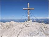
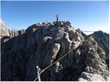
 | D station - Visoki Kanin
Visoki Kanin is the highest peak of the Kanin mountains. From the summit, which has a cross, there is a nice view of the western Julian Alps, and...
2 h 30 min |
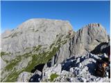
 | Vršič - Mala Mojstrovka (Hanzova pot)
Mala Mojstrovka is one of the most visited peaks in the Julian Alps due to the relatively high elevation of its starting point. From the summit, ...
2 h 15 min |
| Erjavčeva koča na Vršiču - Mala Mojstrovka (Hanzova pot)
Mala Mojstrovka is one of the most visited peaks in the Julian Alps due to the relatively high elevation of its starting point. From the summit, ...
2 h 25 min |
 | Jochalm - Kleiner Reißkofel (path 235)
Kleiner Reißkofel is a 2,161-meter-high mountain east of Reißkofel. From the summit, where a cross stands, there are fine views of the nearby Rei...
2 h 25 min |
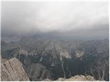
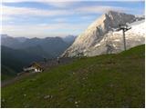
 | Rifugio Auronzo - Monte Paterno (Ferrata De Luca-Innerkofler)
Monte Paterno is a 2744-meter-high panoramic peak. From the top, there is a breathtaking view in all directions, especially the Tre Cime to the w...
1 h 50 min |
| Rifugio Auronzo - Monte Paterno (via east ridge)
Monte Paterno is a 2744-meter-high panoramic peak. From the top, there is a breathtaking view in all directions, especially the Tre Cime to the w...
2 h |
| Rifugio Auronzo - Monte Paterno
Monte Paterno is a 2744-meter-high panoramic peak. From the top, there is a breathtaking view in all directions, especially the Tre Cime to the w...
1 h 40 min |
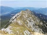
 | Passo di Giau - Averau (via Nuvolau)
Averau is a 2,649 m peak situated between the Alpine passes Passo di Giau and Passo Falzarego (southwest of Cortina d'Ampezzo). The summit, marke...
2 h 35 min |
| Passo di Giau - Averau
Averau is a 2,649 m peak situated between the Alpine passes Passo di Giau and Passo Falzarego (southwest of Cortina d'Ampezzo). The summit, marke...
1 h 55 min |
| Passo Falzarego - Averau
Averau is a 2,649 m peak situated between the Alpine passes Passo di Giau and Passo Falzarego (southwest of Cortina d'Ampezzo). The summit, marke...
2 h 30 min |
 | Rifugio Sorgenti del Piave - Monte Chiadenis (southwest route)
Monte Chiadenis is a 2,459-meter-high mountain located between Monte Peralba and the Crete Cacciatori peak. From the summit, which has a summit r...
2 h |
 | Rifugio Sorgenti del Piave - Monte Chiadenis (CAI di Portogruaro)
Monte Chiadenis is a 2,459-meter-high mountain located between Monte Peralba and the Crete Cacciatori peak. From the summit, which has a summit r...
2 h 30 min |
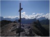
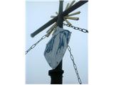 | Koča Porze - Porze / Cima Palombino (via Tilliacher Joch (Italian ferrata))
Porze is a 2,599 m high mountain in the border/main ridge of the Carnic Alps, above the upper course of the Zilja River. The rocky summit massif ...
2 h 30 min |
 | Koča Porze - Porze / Cima Palombino (via notch Porze (Austrian secured path))
Porze is a 2,599 m high mountain in the border/main ridge of the Carnic Alps, above the upper course of the Zilja River. The rocky summit massif ...
2 h 30 min |
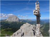 | Passo Gardena - Gran Cir / Große Cirspitze
Gran Cir / Große Cirspitze is a 2592-meter-high peak located in Puez-Odle / Puez-Geisler Nature Park in the Puez group. From the summit, which ha...
1 h 30 min |
 | Passo di Fedaia - Bech da Mesdi (Ferrata delle Trincee)
Bech da Mesdi is a 2727-meter-high peak located north of Passo Fedaia pass. The peak is known primarily for the interesting via ferrata Ferrata d...
2 h 30 min |