Mönichkirchen - Hochwechsel (via Studentenkreuz)
Starting point: Mönichkirchen (1006 m)
| Latitude/Longitude: | 47,51217°N 16,03173°E |
| |
Route name: via Studentenkreuz
Walking time: 3 h 45 min
Difficulty: easy marked way
Elevation gain: 737 m
Elevation difference along the route: 800 m
Map:
Recommended equipment (summer):
Recommended equipment (winter): ice axe, crampons
Views: 117
 | 1 person like this post |
Access to starting point:
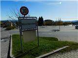
We leave the A2 highway Graz–Vienna/Wien at the Pinggau, Friedberg exit, then from the nearby roundabout we take the exit in the direction of the mentioned places and Vienna and Graz. A few kilometers ahead at the intersection of regional roads we follow the signs for Vienna and Mönichkirchen. We then drive along Wechsel Straße, the mentioned road which mainly ascends, leaving it at the exit for Mönichkirchen. Next comes driving through the settlement to a larger parking lot above the settlement, which is located at the foot of the ski slope.
Route description:
On the right, eastern side of the parking lot, the asphalt road continues, along which there are a few more parking areas, and we ascend along it beside the ski slope. After a few minutes we arrive at a marked junction, where the path to Mönichkirchner-Schwaig splits into two parts.
We continue slightly left in the direction of the Studentenkreuz cross and continue across the ski slope (carefully due to crossing the track route used for downhills in the summer season). We continue under the chairlift; when the road turns left, we go straight onto the marked footpath, which quickly splits in the forest. At the junction by the hunting observatory we go left again, in the direction of the previously mentioned cross. There follows a few minutes of somewhat steeper ascent through the forest; after crossing a grassy cart track, the path gradually flattens. We continue ascending through the forest, and at the previously mentioned cross we reach the macadam road, which we follow left towards Vorauer Schwaig and Hallerhaus (right Mönichkirchner-Schwaig). The path continues along a gently sloping macadam road; at the marked junction we go straight ahead, still towards Vorauer Schwaig and Hallerhaus.
At the next marked junction we leave the road and continue slightly left towards Vorauer Schwaig (straight Hallerhaus). We continue easily through the forest, passing a smaller shrine; shortly after we reach a cart track, which we follow left, quickly reaching a macadam road along which we continue a gentle ascent for a short time. From the road we soon go slightly right and then ascend moderately. Higher up we cross a wider cart track (right Hallerhaus) and continue diagonally ascending. Somewhat further we briefly step onto a macadam road and quickly leave it. A little further we cross the road again, and higher we continue along it. A few minutes further we go slightly left from the road, continuing to ascend diagonally, this time through increasingly sparse forest. When we leave the forest along the cart track, i.e., the last section of the road, we soon arrive at the Vorauer Schwaig hut.
At Vorauer Schwaig several paths join from the left, and to the right a path branches off to Niederwechsel; we continue straight towards Hochwechsel, bypassing the military cemetery on the left side. There follows a longer traverse along the cart track, which continues with some shorter ascents and descents; most of the time there are beautiful views of the surrounding hills. Later a path branches off slightly left towards the Kaltwiesenhütte and Rablkreuz Hütte huts; we continue slightly right, where we gradually begin to ascend more noticeably. There follows some diagonal ascent, and at 1647 m altitude we reach a junction where we join the path leading over the Niederwechsel summit.
We continue straight (sharply right Niederwechsel) and begin first gently, then moderately to ascend. We follow this path to the Wetterkoglerhaus am Hochwechsel hut, where we step onto the road. We cross the road at the beginning of the parking lot and walk to the summit a few steps away.
Starting point - Vorauer Schwaig 2:30, Vorauer Schwaig - Hochwechsel 1:15.
Description and pictures refer to the condition in October 2022.

Photos:
 1
1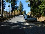 2
2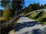 3
3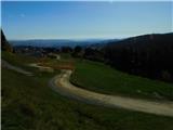 4
4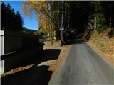 5
5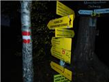 6
6 7
7 8
8 9
9 10
10 11
11 12
12 13
13 14
14 15
15 16
16 17
17 18
18 19
19 20
20 21
21 22
22 23
23 24
24 25
25 26
26 27
27 28
28 29
29 30
30 31
31 32
32 33
33 34
34 35
35 36
36 37
37 38
38 39
39 40
40 41
41 42
42 43
43 44
44 45
45 46
46 47
47 48
48 49
49 50
50 51
51 52
52 53
53 54
54 55
55 56
56 57
57 58
58 59
59 60
60 61
61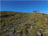 62
62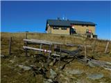 63
63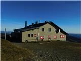 64
64 65
65 66
66 67
67
Discussion about the trip Mönichkirchen - Hochwechsel (via Studentenkreuz)
To post a comment you must log in:
If you do not yet have a username, you must first
register.