NC Planica - Bivak pod Kotovim sedlom
Starting point: NC Planica (931 m)
| Latitude/Longitude: | 46,47600°N 13,72410°E |
| |
Walking time: 3 h 30 min
Difficulty: difficult marked way
Elevation gain: 1046 m
Elevation difference along the route: 1050 m
Map: TNP 1:50.000
Recommended equipment (summer): helmet
Recommended equipment (winter): helmet, ice axe, crampons
Views: 13.206
 | 2 people like this post |
Access to starting point:
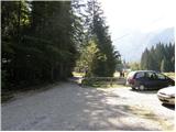
a) First we drive to Kranjska Gora, then continue driving towards Rateče. When we arrive at the roundabout near Rateče, we take the exit in the direction of Planica. This is followed by some ascent and we arrive at the large parking lot next to the Nordic Centre Planica, where we park in the paid parking lot. The price for passenger cars is 2.5 EUR/day (March 2019).
b) Via the Rateče border crossing we drive into Slovenia, then soon turn right towards Planica. This is followed by some ascent and we arrive at the large parking lot next to the Nordic Centre Planica, where we park in the paid parking lot. The price for passenger cars is 2.5 EUR/day (March 2019).
Route description:
From Planica we continue along the gravel road towards the Dom v Tamarju, before the road enters the forest it splits into two parts. We continue along the slightly right road in the direction of the hiking trail towards Tamar (slightly left is the drivable road, which is closed to public traffic).
The path ahead leads us along the road that passes by the last parking lot of NC Planica, enters the forest and is converted into a cross-country ski track in winter. This is followed by an ascent along a gentle road that mostly runs through the forest. When the path leaves the forest, there are viewpoints along the path with signs indicating what can be seen. Higher up the forest thins out several times or we leave it for a while, so that beautiful views open up to the mountains rising above Planica and Tamar. When we get quite close to the Dom v Tamarju, a wonderful view of Jalovec opens up and the path branches.
We continue slightly left (slightly right is the spring of the Nadiža) and a few minutes later join the drivable road, along which we pass a chapel and arrive at the Planinski dom v Tamarju.
We continue along the marked mountain path in the direction of Jalovec and Ponce (left Slemenova špica). The path ahead leads us through the forest, which quickly brings us to the next junction, where the path to Ponce branches off to the right. We continue in the direction of Jalovec and continue the ascent along the path that still ascends gently through the forest for a short time. When we exit the forest we first ascend for some time across extensive, partly already overgrown gravel fields, then gradually arrive at the scree that continues towards Jalovčev ozebnik. Along the scree we climb up to the marked junction, where we continue right in the direction of Jalovec along the path past the bivouac and across Kotovo sedlo (straight ahead Jalovška škrbina and the path to Jalovec which leads across the scree to Kotovo sedlo).
From the junction onwards the path goes onto steep slopes across which we begin to ascend. Further the path leads us over some somewhat more difficult sections where safety equipment assists us. Higher up the path turns left and gradually levels out. The path continues along a belt of dwarf pines, and on the right side, about 100 meters from the marked path we notice the Bivak pod Kotovim sedlom which is located under a larger boulder (in fog we will have difficulty spotting where the bivouac is located).
At this point we leave the marked path and walk via easy off-trail terrain to the bivouac.
Planica - Dom v Tamarju 0:45, Dom v Tamarju - razpotje Mali kot 1:30, razpotje Mali kot - Bivak pod Kotovim sedlom 1:15.

Along the route: Dom v Tamarju (1108m), Odcep za Ponce (1119m), Helioport Pod Brkico (1357m), Razpotje Mali kot (1564m), Rob planote (1889m)
Photos:
 1
1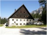 2
2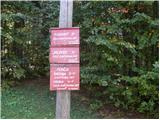 3
3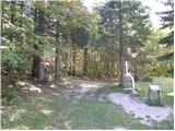 4
4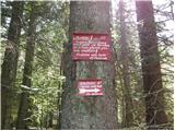 5
5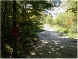 6
6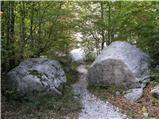 7
7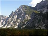 8
8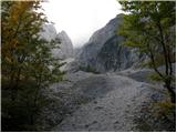 9
9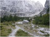 10
10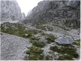 11
11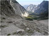 12
12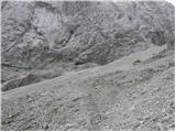 13
13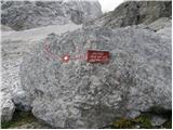 14
14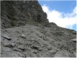 15
15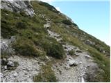 16
16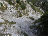 17
17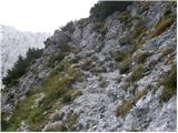 18
18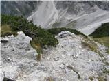 19
19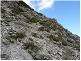 20
20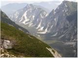 21
21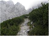 22
22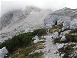 23
23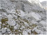 24
24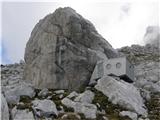 25
25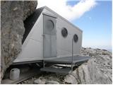 26
26
Discussion about the trip NC Planica - Bivak pod Kotovim sedlom
|
| m.b.2. 10. 2011 |
Beautiful tour and complete description of the path on this side. But I couldn't open the bivouac to get the stamp.
|
|
|
|
| Bobaje9. 12. 2011 |
Yesterday with the dog over Brkica to the bivouac to lubricate this cheeky latch. Well, when I finally tackled the task that lured me up, the lubricant was completely useless I compensated with sunscreen cream. Hope it will be better, if not - repeat! OK then I also cleaned the entrance portal, enjoyed the sunshine a bit and hurried back to the valley to pick up the little goblin from kindergarten. I compensated with sunscreen cream. Hope it will be better, if not - repeat! OK then I also cleaned the entrance portal, enjoyed the sunshine a bit and hurried back to the valley to pick up the little goblin from kindergarten.
Oh, and conditions: up to the junction over Brkica no winter gear needed, from the junction onwards it's mandatory. Under Pršič finger it's pure ice. Higher up there's already quite some snow, but gaiters unfortunately not yet mandatory. These conditions are probably history now, as it started drizzling nicely above 1800 just before dark. Well, we'll see.
Best regards, Bobaje
|
|
|
|
| m.b.10. 12. 2011 |
I knew I had to tell you right, and everything is fixed.....Thanks! ...I'll check if it's okay for my muscles ...I'll check if it's okay for my muscles LP LP
the view of Jalovec is always worth seeing
|
|
|
To post a comment you must log in:
If you do not yet have a username, you must first
register.