NC Planica - Dom v Tamarju (by road)
Starting point: NC Planica (945 m)
| Latitude/Longitude: | 46,47600°N 13,72410°E |
| |
Route name: by road
Walking time: 45 min
Difficulty: easy marked way
Elevation gain: 163 m
Elevation difference along the route: 170 m
Map: Kranjska Gora 1:30.000
Recommended equipment (summer):
Recommended equipment (winter):
Views: 158.416
 | 6 people like this post |
Access to starting point:
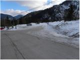
a) First we drive to Kranjska Gora, then continue driving towards Rateče. When we arrive at the roundabout near Rateče, we take the exit towards Planica. There follows some more ascent and we arrive at the large parking lot by the Nordic Center Planica, where we park at the paid parking lot. Price for personal vehicles is 2.5 eur / day (March 2019).
b) Through the border crossing Rateče we drive into Slovenia, then soon go right towards Planica. There follows some more ascent and we arrive at the large parking lot by the Nordic Center Planica, where we park at the paid parking lot. Price for personal vehicles is 2.5 eur / day (March 2019).
Route description:
From the parking lot, we continue on a macadam road, which quickly brings us to the intersection of two roads. We continue on the left upper road (to the right cross-country ski trail), which ascends slightly to moderately and runs partly through the forest, partly over panoramic slopes. Higher up, the path through Grlo branches off to the left (the mentioned path leads to Slemenova špica, Mala Mojstrovka and Vršič), and we continue straight and follow the road all the way to its end at the mountain hut Dom v Tamarju.
We can also reach the mountain hut along the parallel mountain path, but note that it is closed in winter due to the cross-country ski trail.
Photos:
 1
1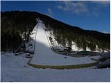 2
2 3
3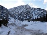 4
4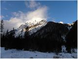 5
5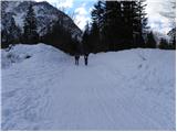 6
6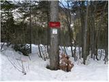 7
7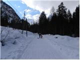 8
8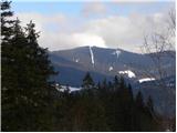 9
9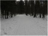 10
10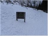 11
11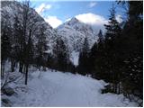 12
12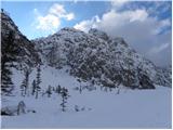 13
13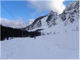 14
14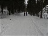 15
15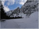 16
16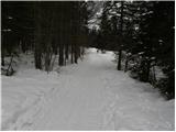 17
17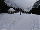 18
18 19
19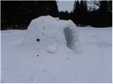 20
20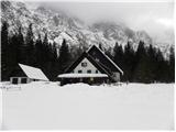 21
21
Discussion about the trip NC Planica - Dom v Tamarju (by road)
|
| klavdy610. 01. 2009 |
very suitable for a winter trip
|
|
|
|
| Ljubljana24. 09. 2009 |
The beauties of Tamar have only one flaw: the staff at the hut. When we were with a group in front of the hut, foreigners who spoke English were sitting next to us. The hut staff didn't even try to understand what they wanted to order and ask. Arrogantly they let them wait, meanwhile serving other guests. Sad, sad ... We Slovenians are people!
|
|
|
|
| živica5. 11. 2010 |
I'm curious how the hut is open in the autumn-winter period, or if it is at all... is it closed?
|
|
|
|
| turbo5. 11. 2010 |
More precisely, this year it's open only until including 31.12.
|
|
|
|
| JusAvgustin6. 12. 2010 |
today with Robi to Tamar, there's quite a bit of snow, went to the hut, then also through the forest towards Jalovec. The snow is terrible, sticks to the skis and balls form. But we still spent nice 4 hours in strong wind and sleet. Who says that when you go somewhere the conditions have to be optimal? Waterfalls are forming, Lucifer too, unless this thaw fucks it up first!
Hut is open, stove wasn't lit.
|
|
|
|
| trotl14. 01. 2011 |
Today's day was nice, lots of snow from Planica to the hut is not drivable, except if you hitch someone to pull you on sleds. In the hut not very friendly staff or they had a bad day  . .
|
|
|
|
| Otto15. 01. 2011 |
Unfortunately they have a bad day (too) often.
|
|
|
|
| ich16. 02. 2011 |
I'm wondering if it's possible to sledge on the road from the hut to the ski jump? What about on the cross-country track?
|
|
|
|
| KristinaG16. 02. 2011 |
For us cross-country skiers, there's nothing worse than hikers and other non-skiers on the cross-country track. So... NO sledging on the cross-country track! It's a nice walking path made for pedestrians.
Sledging might be arranged at the ski slope next to the Dom v Planici. But from Tamar to Planica it won't go quickly. 
There's a sledge run made or arranged in Kranjska Gora.
|
|
|
|
| JusAvgustin17. 02. 2011 |
Every fool should know that you don't sledge on cross-country tracks, just like you don't walk on touring ski slopes. Yet there are still donkeys who gladly churn up the ski slopes and sledge on cross-country tracks. Nice words don't work, maybe it's time for some more drastic measures...
Every "taprau" mountaineer knows: one is the footpath, the other for touring skiers. But there are many who think there's less churning on touring ski, cross-country tracks (spurs)...
|
|
|
|
| mukica17. 02. 2011 |
Yes, tapravi I know that shouldn't be done, but it's also true that some touring skiers go right on the footpath tracks (e.g. to Komna or towards Blejska koča, if they don't make their own spur ) )
|
|
|
|
| pohodnik0117. 02. 2011 |
Where is our beautiful Slovenian language?
|
|
|
|
| turbo17. 02. 2011 |
Our Slovenian:
footpath = gaz
spur (ski, cross-country) = ?!?
How do you nicely say "spur" in Slovenian?
ski slope? ski track? track?
Otherwise, car on the road and pedestrian on the sidewalk. Pedestrian on the gaz and skier on the ski track (spur?). And of course, cyclist on the bike path.
Right, could we say ski track and footpath gaz ?!?
|
|
|
|
| potočan22. 02. 2012 |
For hikers it is very poorly maintained. I do not recommend taking sleds.
For cross-country skiers it must be reasonably maintained as there were fuul velikkukr I saw yesterday; there were very few. There were more of us "hikers" who were not satisfied. I think this year nothing has been "groomed" yet. Bad opinion of the maintainer!!!!!
|
|
|
|
| vrtnca14. 08. 2012 |
I'm just interested in what the path to the Nadiža stream is like?
|
|
|
|
| sh14. 08. 2012 |
In front of Dom v Tamarju the path branches off to the right. At the start it runs across the bed of the Nadiža itself and then climbs quite steeply in zigzags. At the end before the source itself there is a more demanding section, secured with a cable. Nothing overly difficult. Tested: even 6-year-old children can manage it, possibly even younger.
|
|
|
|
| ninca16. 11. 2012 |
does anyone know if the road to the tamar valley is closed or open?
|
|
|
|
| Janez Seliškar16. 11. 2012 |
The road to Tamar valley is closed beyond the Planica ski jumps for public motor vehicle traffic. Pedestrians are certainly welcome!
|
|
|
|
| Karolin24. 08. 2013 |
Please for information, where in Planica can I park. How much does it cost? We continue on foot to Tamar. Thanks!
|
|
|
|
| Karolin24. 08. 2013 |
Thanks JusAvgustin! Where in Planica can I park?
|
|
|
|
| Karolin24. 08. 2013 |
Sorry! Where in Planica can I park? Thanks!
|
|
|
|
| irska24. 08. 2013 |
@Karolin: I'm sure the parking lot in Planica will be marked
|
|
|
|
| Enka24. 08. 2013 |
In Planica there are huge parking lots opposite the ski jumps and everything is well marked. You can also ask the uncle who will collect 2 euros from you right at the entrance.
|
|
|
|
| pikica124. 08. 2013 |
Parking lots start right from the booth where they collect the parking fee. Along the road on the left side when you enter Planica. Six large parking lots, one after another. The second in line is currently closed because there are containers placed there for workers building the ski jumps and those ski jumpers' cabins. You have five left, pay whatever you want
|
|
|
|
| Karolin26. 08. 2013 |
Thanks for the information "irska", "Enka" and "pikica1"! Regards!
|
|
|
|
| slamca24. 01. 2015 |
Some new snow has fallen on the trail, but there's ice underneath, caution is advised.
|
|
|
|
| GregorD28. 03. 2016 |
Today we went on this trail and it was nice. At 9:00 (still) they weren't charging for parking, there's a track for runners on the left and right, in between a walking path, on which boys and girls on touring skis overtook us. No unpleasant experiences with the hut staff either, though at 10:00 there weren't many people. At 11:00, when we were returning, it was like a weekday at Čopovi.
|
|
|
|
| redbull17. 11. 2017 |
Super, photos top
Good luck
|
|
|
|
| zlatica19. 11. 2017 |
Majda, you've found a beautiful winter fairy tale again and delighted our heart and eye with photos. Best regards
|
|
|
|
| Majdag19. 11. 2017 |
...Thanks Redbull, Zlatica, let those who can't see it themselves enjoy it too.
|
|
|
|
| dleskovec19. 11. 2017 |
Majda; I would like to praise your photos and also the pleasant descriptions or trail reports (not the first time). Yes, unfortunately not everyone is given (we are too far) to see the beautiful white path to Tamar and therefore thank you.
Just a small remark: since your descriptions sometimes delay, wouldn't it be better to post the description first and then add the picture?
And have a good time in the beautiful winter!!
|
|
|
|
| Majdag20. 11. 2017 |
Thanks Dleskovec, I really have a day or two delay. The blog is not made as quickly as some might think. The text also takes its time. Pictures complement the whole, without them it wouldn't have the same effect. I can't sit down at the computer right after returning from the hike and make a post. There are other things that take priority. I think that things don't change so much in two days that the thing is already outdated. It can also be an idea for someone for the next right moment. I'm glad if I brighten someone's day. You know, better late than never.
|
|
|
|
| skalar5031. 01. 2018 |
... (almost) full moon ...clear starry sky ... illuminated Jalovec ... some night sledders in front of the hut in Tamar ... otherwise complete peace
|
|
|
|
| Keki22. 12. 2018 |
How much snow is there on the road to Tamar, is sledding possible yet?
|
|
|
|
| potpodnoge31. 07. 2020 |
Today we headed to Tamar. At the lower parking lot, left of the path to the hotel, we parked on the gravel parking lot. At 10 o'clock already warm air, lots of people and lots of cars parked up to the sign prohibiting further driving. On the path right of the road, mostly really pleasant shade, few people. Here and there someone on a bike, but the path is wide, so no problem. People mostly friendly and after an hour of slow walking, here it is, the hut in Tamar before us. Terrace almost full, people at tables changing over, so it wasn't hard to get a table in the shade. Service quick, the lady friendly. On the way back around 12 o'clock there was quite a rush on the path to the hut. We also noticed that everyone had dogs on leashes, which is praiseworthy. Weather too hot even for such a short trip. Luckily most of the path is in shade, so the heat is somewhat softened. Those who like hot air could fully enjoy. Still a pleasant day but a bit too hot for us, but that's the smallest problem, as the weather forecast predicted rain from 11 o'clock onwards. So the umbrella stayed in the backpack, but the shirt was still completely soaked with sweat.
|
|
|
|
| Majdag11. 09. 2020 |
Dolina Tamar and Črna voda waterfall...To Tamar by road, back by footpath. Fog ruled on Tuesday,
practically nothing was visible anywhere. In the morning, hikers overtook us on the road hurrying to the summits. The footpath through the valley is very torn up. On this path we met many people, many elderly.
https://jelenkamenmajdag.blogspot.com/2020/09/tamar-v-meglicah.html
|
|
|
|
| Tomaž0028. 12. 2022 12:37:28 |
Yesterday on this path nothing but crowds
|
|
|
|
| Ales6227. 06. 2023 07:45:33 |
Visited Dom v Tamarju yesterday. Short assessment is that Planica is top-notch arranged for ski jumping competitions, since last visit added parking meters and barriers, but otherwise completely without shade. Incomprehensible that shade is only on parking lots where campers park, personal vehicles only in the sun, enormously hot, especially if you come with a small child. I don't know where their heads were, I'd say they turned natural beauty into a concrete polygon. If you come with a child up to 1.5 years old, I advise against this destination. Also the path to Dom v Tamarju along the road 80% in the sun, the other path, say the forest one, 50% in the sun. If anyone is thinking, both paths can be done with a quality stroller, otherwise quite a few longer climbs (e.g. 2-3), but mandatory until 9 a.m., later unsuitable when clear day over 28 degrees is forecast. From Planica there 45 minutes along the road, back 35 minutes brisk walk along the forest path. Prices at Dom v Tamarju moderate and acceptable. Otherwise suitable for a nice outing, met quite a few families with children from 3 or 4 years and older, and also quite a few cyclists.
|
|
|
|
| Majdag22. 02. 2025 09:40:57 |
19.2. The hiking group DU J.K. Bela roamed the Tamar valley and further to Črne vode on Wednesday. Instead of sun, fog reigned. But it was nice anyway. The road was still passable without microspikes in the morning, but on the way back they were already necessary. There were many small and large children visiting. They were also sledding on the road. Through the valley with glimpses of the peaks, there is a cross-country ski track set up and it's not for pedestrians.
https://jelenkamenmajdag.blogspot.com/2025/02/zimska-pravljica-tamar.html
|
|
|
|
| Majdag11. 01. 2026 07:55:35 |
A.D.K.
ONE of the definitions: "Discourse is a system of representation that develops in society and enables coordinated communication in a particular area of interest."
Whatever one thinks. Debate can be under this or another title. Questions and answers are possible everywhere. The only difference is that under this section you can't upload pictures. Tadej will have to move everything or define the title better, good luck.]]>
|
|
|
To post a comment you must log in:
If you do not yet have a username, you must first
register.