NC Planica - Kotovo sedlo (via bivak)
Starting point: NC Planica (945 m)
| Latitude/Longitude: | 46,47600°N 13,72410°E |
| |
Route name: via bivak
Walking time: 3 h 55 min
Difficulty: difficult marked way
Elevation gain: 1189 m
Elevation difference along the route: 1205 m
Map: Kranjska Gora 1:30.000
Recommended equipment (summer): helmet
Recommended equipment (winter): helmet, ice axe, crampons
Views: 31.517
 | 1 person like this post |
Access to starting point:
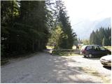
a) First we drive to Kranjska Gora, then we continue driving towards Rateče. When we arrive at the roundabout near Rateče, we take the exit in the direction of Planica. This is followed by some ascent and we arrive at the large parking lot next to the Nordic Centre Planica, where we park at the paid parking lot. The price for passenger cars is 2.5 euros / day (March 2019).
b) Via the Rateče border crossing we drive into Slovenia, then we soon turn right towards Planica. This is followed by some ascent and we arrive at the large parking lot next to the Nordic Centre Planica, where we park at the paid parking lot. The price for passenger cars is 2.5 euros / day (March 2019).
Route description:
From Planica we continue along the macadam road towards Dom v Tamarju, before the road enters the forest it splits into two parts. We continue along the slightly right road in the direction of the hiking path towards Tamar (slightly left is the drivable road, which is closed to public traffic).
The path ahead leads us along the road, which passes the last parking lot of NC Planica, enters the forest and which in winter is converted into a cross-country ski track. This is followed by an ascent along a gentle road that mostly runs through the forest, when the path leaves the forest, there are viewpoint boards along the path with inscriptions about what can be seen. Higher up the forest thins out several times or we leave it for a while, so beautiful views open up of the mountains rising above Planica and Tamar. When we are already quite close to Dom v Tamarju, a wonderful view of Jalovec opens up, the path splits.
We continue slightly left (slightly right is the spring of Nadiža) and a few minutes later we join the drivable road, along it past a small chapel we arrive at Planinski dom v Tamarju.
We continue along the marked mountain path in the direction of Jalovec and Ponce (left Slemenova špica). The path ahead leads us through the forest, which quickly brings us to the next junction, where the path to Ponce branches off to the right. We continue in the direction of Jalovec and continue the ascent along the path that ascends gently through the forest for a short time. When we come out of the forest we first ascend for some time over extensive, partly overgrown scree fields, then gradually arrive at the scree that continues towards Jalovčev ozebnik. Along the scree we climb to the marked junction, where we continue right in the direction of Jalovec along the path past the bivouac and over Kotovo sedlo (straight ahead Jalovška škrbina and the path to Jalovec, which leads over the scree to Kotovo sedlo).
From the junction onwards the path goes onto steep slopes over which we begin to climb. In the continuation the path leads over some somewhat more difficult sections where we are helped by safety features. Higher up the path turns left and gradually levels out. The path continues along a belt of dwarf pines, and on the right side, about 100 meters away from the marked path we notice the Bivak pod Kotovim sedlom, which is located under a larger boulder (in fog it will be hard to spot where the bivouac is located).
If we want to go right to the bivouac, at this point we leave the marked path and walk over easier pathless terrain to the bivouac.
We continue the path along a moderately steep slope on which we notice a larger number of boulders and larger rocks. Here the previously mentioned path that runs over the scree joins us from the left, we continue straight and after a few minutes of further ascent we arrive at Kotovo sedlo.
Planica - Dom v Tamarju 0:45, Dom v Tamarju - razpotje Mali kot 1:30, razpotje Mali kot - Bivak pod Kotovim sedlom 1:15, Bivak pod Kotovim sedlom - razpotje Veliki kot 0:15, razpotje Veliki kot - Kotovo sedlo 0:10.

The trip can be extended to the following destinations: Jalovec
Photos:
 1
1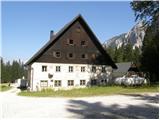 2
2 3
3 4
4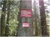 5
5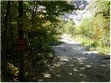 6
6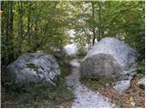 7
7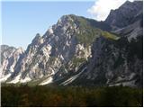 8
8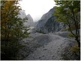 9
9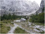 10
10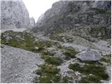 11
11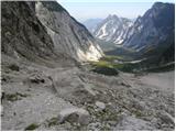 12
12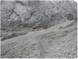 13
13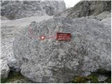 14
14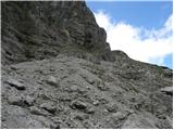 15
15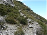 16
16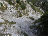 17
17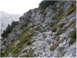 18
18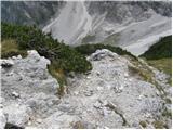 19
19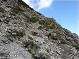 20
20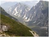 21
21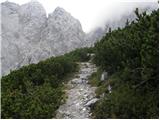 22
22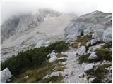 23
23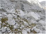 24
24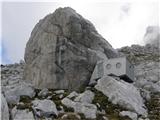 25
25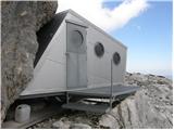 26
26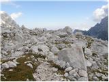 27
27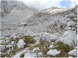 28
28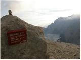 29
29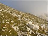 30
30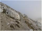 31
31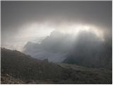 32
32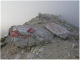 33
33
Discussion about the trip NC Planica - Kotovo sedlo (via bivak)
|
| jersy24. 09. 2008 |
What is the path to the saddle from Koritnica valley like? Nicer? Demanding?
|
|
|
|
| triglavski24. 09. 2008 |
First, all paths in the mountains are beautiful, but some are nicer and very beautiful, difficulty is not measured only by how exposed the path is, how many safety devices it has and so on, but also length, steepness and similar things. I adapt my mountain hikes also to the location and season. Now this path is completely in the shade and you will see the sun only at the saddle, if it is not cloudy by chance, so this path is very suitable for a hot summer day, because it will be pleasantly cool there. Otherwise, it is somewhat more demanding than the one from Tamar.
|
|
|
|
| Kriška24. 09. 2008 |
Question: how can I drive to the Dom v Tamarju when the road from Planica onwards is closed to all traffic?
|
|
|
|
| Tadej24. 09. 2008 |
Before the barrier it says that the road is open from 18:00 to 6:00 and from 12:00 to 14:00. On the way out between 12:00 and 14:00 you should pay for parking.
|
|
|
|
| triglavski24. 09. 2008 |
In Gorenjski glas it says that the barrier has been removed.
|
|
|
|
| jersy24. 09. 2008 |
triglavski thanks for the explanation. how do you find the route suitable for this Sunday (if there is sun of course) Tamar-Jalovška šrbina-summit-Kotovo sedlo-Tamar?
|
|
|
|
| Kriška25. 09. 2008 |
Triglavski, I think my question was precise enough. Look at this photo, based on which you can see that there is a traffic sign "prohibited for all traffic", barrier and additional sign "permitted for landowners":
http://hribi.net/Pot/rimg0449mediumxz8.jpg
|
|
|
|
| Kriška25. 09. 2008 |
Regarding the article in Gorenjski glas that you recommended reading, here's this:
This article also indicates (if the proposal is adopted as is) that driving will be prohibited for all motor vehicles, except for landowners, emergency vehicles, and vehicles supplying mountain huts. And nothing is written about allowing ordinary mortals to drive at certain hours of the day.
|
|
|
|
| triglavski25. 09. 2008 |
If it will be, if not, then not, besides, nowhere does it say that you can only go to Kotovo sedlo if you drive to Tamar. You can easily go to Kotovo sedlo from Planica too, on foot of course, because you can't drive to the end of Loška Koritnica either, there's a barrier and a sign there too, so I don't even know what the problem is, I just wrote where I walk sometimes and where there's shade and where there's sun.
Jersy, probably no problems on the south side, but the descent from Jalovec to Kotovo sedlo might be tricky because there's snow there.
|
|
|
|
| Kriška25. 09. 2008 |
Triglavski, don't get upset ... My first question wasn't even addressed to you, but based on the access description, these two things didn't go together for me: My first question wasn't even addressed to you, but based on the access description, these two things didn't go together for me:
- prohibited traffic
- access instruction: drive to Dom v Tamarju.
Besides, the photo I had in mind had no additional data about the road being occasionally open.
|
|
|
|
| triglavski25. 09. 2008 |
Kriška, I'm not upset, regarding the previous regime that applied to occasional traffic probably for ten years (experts correct me, I don't drive there in summer), the sparrows were already chirping about it as they say, and there were quite a few debates on forums too, of course this isn't the only one and sometimes you need to look at others, sometimes just type something into Google, najdi.si or other websites where you can find almost everything. What bothers me most is how some are so narrowly focused on just one website, one forum, and if they don't get an answer right away there, the world almost collapses. I'm seriously worried how such people even manage in the mountains, well some don't at all.
|
|
|
|
| žl27. 09. 2008 |
On Thursday I was in Tamar. A little run with Rateče for recreation on a gloomy and occasionally rainy day. There's no ramp anymore. Candles are burning and a white bouquet of roses along the path. Also a new sign that driving is allowed for residents from such and such time.... I didn't remember everything because it didn't interest me. I've been to Tamar many times, always on foot. So Kriška pot under my feet.... Triglavski has very smart and useful tips. You can see it's all from practice.
|
|
|
|
| Kriška27. 09. 2008 |
Believe it or not "žl", I too have been to Tamar many times (running for a few decades), and always on foot!
However, the time comes when it's good for a person to shorten some tour, especially if it's walking on the road, so to speak on the flat. I still like to hike in the mountains, but I can't manage such long day trips anymore as I used to, so shortening the path like this e.g. to Kotovo sedlo or further or higher from the starting point in Tamar saves me a good hour of walking.
Of course, it doesn't even occur to me to drive to the Dom v Tamarju just to sit there and do a loop around the meadow ... (that might come in handy someday - I hope - much later, when I won't be able to treat myself to anything anymore).
|
|
|
|
| BRAZONIK16. 02. 2012 |
Hi, I'm interested if anyone has skied to Kotovo sedlo recently, what are the conditions. Forecast for Saturday is ok.
|
|
|
|
| som6916. 02. 2012 |
At the ski touring club Gora there is a report from 15.2.
|
|
|
|
| BRAZONIK16. 02. 2012 |
som69 thanks for the info.
|
|
|
|
| tagec21. 05. 2014 |
After 2 days on the bike, snow tempts me again. Nina has no climbing partner, so I change plans and instead of from Kot to Rž, we go together to Kotovo sedlo. The trail in snowshoes from Planica to Tamar is long, soon after the hut snow starts and it's immediately easier. The snow is firm enough that Nina doesn't sink in, unfortunately the weather worsens and today there wasn't much warmth. Fog or clouds lingered over Mojstrovke, gradually spreading towards Jalovec, so no views. We met 10 hikers, two went via ozebnik to Jalovec, the rest enjoyed solid glissading from the saddle. Quite windy too, but didn't blow away the clouds, so nothing of the promising forecast for one of the nicer days. In Planica sun again and over 20 degrees
|
|
|
|
| cvetlica8921. 05. 2014 |
At what time did you ski down?
|
|
|
|
| SamoK21. 05. 2014 |
Unfortunately, you were one day late. Tuesday was the right day for skiing 
|
|
|
|
| tagec23. 05. 2014 |
Yes, I believe Tuesday was a better day. We two were last at the saddle, but even the early risers said that the snow on top was already soft in the morning, lower ok, so it held also at 13h when we started descent..
|
|
|
|
| ZoranV24. 05. 2014 |
Almost the entire trail in one picture. Bottom right Dom v Tamarju, top left Kotovo sedlo.
|
|
|
To post a comment you must log in:
If you do not yet have a username, you must first
register.