Nida - Vouloumenou (Kreta / Crete)
Starting point: Nida (1375 m)
| Latitude/Longitude: | 35,20687°N 24,83502°E |
| |
Walking time: 3 h 30 min
Difficulty: easy marked way, easy pathless terrain
Elevation gain: 892 m
Elevation difference along the route: 1050 m
Map: Anavasi 11.14
Recommended equipment (summer):
Recommended equipment (winter):
Views: 121
 | 1 person like this post |
Access to starting point:
From the town of Heraklion on Crete, we drive to the village of Anogia and then along the asphalt road to the Nida plateau (Eng. Nida plateau; Gr. Οροπέδιο Νίδας). The starting point for the tour already falls under the administrative area of the town of Rethimno.
Route description:
From the parking lot we continue towards the gravel road and, following the signposts, turn onto the footpath, which soon crosses the road twice, then goes past the Analipsi church and then leads back to the road. Behind the bend there are signposts, one shows the direction to Idino cave, the other to Timios Stavros, the highest peak of Psiloritis and Crete.
From the signposts we continue along the road to the pronounced right bend, where the footpath begins. The path from here onwards is marked with two red dots, and on the rocks yellow arrows are sometimes drawn. We follow the well-marked path, which first ascends the slope towards the southwest, then turns towards the northwest, where it passes into mountain valleys surrounded by thorny vegetation. The path follows the mountain valleys in the direction towards the west until it reaches a saddle at 1920 meters above sea level. Here the path descends towards the southwest and leads 100 meters of elevation lower (a direction towards the north is also possible, which is less well-marked, and the path also loses elevation there intermittently).
From here onwards we again follow mountain valleys, which are larger than before, and the vegetation is still present here. The path slowly turns more and more towards the north, crosses a nicely flat basin and climbs to a saddle, from which the view finally opens towards Crete's highest mountain Psiloritis / Timios Stavros.
From here we no longer follow the main path leading west to Psiloritis, but turn towards the east. Locally the path is harder to see, but orientation is not difficult. Best to keep slightly to the left along the trails of the plateau-like terrain towards the summit, which we reach after 20 to 30 minutes of further walking.
Return along the described path or circular with a visit to the also 2209 meters high mountain Kousakas, which is even somewhat shorter but steeper in places.

Along the route: Analipsi (1413m)
Photos:
 1
1 2
2 3
3 4
4 5
5 6
6 7
7 8
8 9
9 10
10 11
11 12
12 13
13 14
14 15
15 16
16 17
17 18
18 19
19 20
20 21
21 22
22 23
23 24
24 25
25 26
26 27
27 28
28 29
29 30
30 31
31 32
32 33
33 34
34 35
35 36
36 37
37 38
38 39
39 40
40 41
41 42
42 43
43 44
44 45
45 46
46 47
47 48
48 49
49 50
50 51
51 52
52 53
53 54
54 55
55 56
56 57
57 58
58 59
59 60
60 61
61 62
62 63
63 64
64 65
65 66
66 67
67 68
68 69
69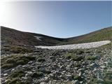 70
70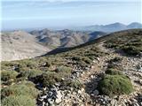 71
71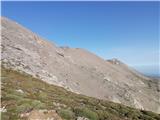 72
72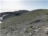 73
73 74
74 75
75 76
76 77
77 78
78 79
79 80
80 81
81 82
82 83
83 84
84 85
85 86
86 87
87 88
88 89
89 90
90 91
91 92
92 93
93 94
94 95
95
Discussion about the trip Nida - Vouloumenou (Kreta / Crete)
To post a comment you must log in:
If you do not yet have a username, you must first
register.