Pernica - Sveti Rupert (Spodnja Voličina)
Starting point: Pernica (247 m)
| Latitude/Longitude: | 46,57787°N 15,72659°E |
| |
Walking time: 4 h
Difficulty: easy marked way
Elevation gain: 39 m
Elevation difference along the route: 370 m
Map:
Recommended equipment (summer):
Recommended equipment (winter):
Views: 67
 | 1 person like this post |
Access to starting point:
Leave the Pomurska motorway at the Pernica exit and then follow the signs to the mentioned place. From the roundabout, take the exit towards the health home, post office, kindergarten, cemetery, cultural home and Strojegradnja Koletnik. Park immediately behind the roundabout on the parking lot by the roundabout, or on the other side of the road on the parking lot next to the cemetery.
Route description:
Already at the parking lot we notice the first Knafelc markings, which we follow southwards, starting to ascend along the sidewalk where houses are still quite frequent along the path. The path soon turns west, higher up from the intersection where the sidewalk ends we continue straight ahead and continue following the Knafelc markings. Higher up we enter a strip of forest, where we bypass the highest point of Gradišče (351 m) on the right side. There follow some short ascents and descents and past individual houses we reach a marked intersection, where we leave the Knafelc markings and continue following the yellow-white markings, keeping the direction towards Ruperče and Zavrh.
There follows some scenic traversing, from where we get a nice view of Pohorje and Dravsko polje, and the path continues for some time along the same route as the Slovenska turno kolesarska pot. When the road turns right downhill, we continue straight onto a side road, along which there are signs for Zimico and Zavrh. This is followed by an ascent between forest on the left and vineyards on the right to two houses where the road ends. We bypass the houses on the right side, then continue along the ridge where the power line is also routed.
When the somewhat wider path from the ridge turns right towards the nearby houses, we continue straight ahead and keep to the ridge, following this path to the summit a few minutes away, which we recognize by the transmitters.
We bypass the transmitters on the right side, the nearby house on the left, and begin descending along the cart track, where after a few dozen steps we go sharply left.
The path ahead leads along the vineyard, lower down past a house we reach a narrower asphalt road and follow it right downhill. The narrow road quickly brings us to a wider road leading from Ložan towards Malečnik, which we follow to the right, walking along it only to the next marked intersection, where we turn left onto a side road with signs for Jablance and Voličino. The path ahead leads along the road which continues without major changes in elevation, at numerous intersections following the signs for Voličino or the yellow-white markings. Occasionally quite scenic road later brings us to the slopes of Homa, where on the western side of the summit we arrive at the arranged Rebra spring.
A little further from the spring we go left onto the footpath, continuing to follow the signs for Voličino. This is followed by some ascent to the southern forested ridge of Huma, then we gradually begin to descend, following the markings at a few forks. When lower down we reach a poorer road we go left, when a minute further we reach the asphalt road we go right, still in the direction of Voličina. Even further on we first descend, later where at intersections we follow the direction for Voličino, the path continues with some shorter ascents and descents.
The path ahead leads through the settlement of Jablance, behind the last house in one of the hamlets the asphalt ends and we descend somewhat steeply along the gravel road, which levels out lower down. When at the chapel we reach the asphalt road we go left and continue following the signs for Voličino, this time the sign next to it also has Zavrh.
Further on we descend easily for quite some time along the valley of the Jablanški potok, the settlement of Jablance soon ends.
Lower down we pass a small pond, when we arrive at the road sign indicating the start of the municipality of Lenart we go right onto the side road, along which the yellow-white markings continue.
This is followed by some ascent through the forest, when the forest ends we bypass the farm on the right side, behind it we gradually descend a little. Further on there are a few intersections where we follow the main road, and we follow the main road all the way to the settlement of Spodnja Voličina.
Starting point - Vavtošek 1:05, Vavtošek - Rebra spring 1:10, Rebra spring - Spodnja Voličina 1:45.
Description and photos refer to the state in February 2023 and November 2025.

Photos:
 1
1 2
2 3
3 4
4 5
5 6
6 7
7 8
8 9
9 10
10 11
11 12
12 13
13 14
14 15
15 16
16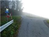 17
17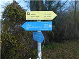 18
18 19
19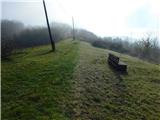 20
20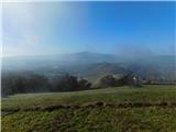 21
21 22
22 23
23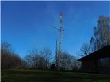 24
24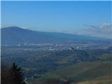 25
25 26
26 27
27 28
28 29
29 30
30 31
31 32
32 33
33 34
34 35
35 36
36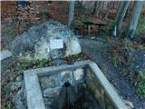 37
37 38
38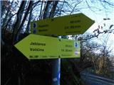 39
39 40
40 41
41 42
42 43
43 44
44 45
45 46
46 47
47 48
48 49
49 50
50 51
51 52
52 53
53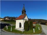 54
54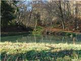 55
55 56
56 57
57 58
58 59
59 60
60
Discussion about the trip Pernica - Sveti Rupert (Spodnja Voličina)
To post a comment you must log in:
If you do not yet have a username, you must first
register.