Starting point: Planina Kuhinja (991 m)
| Latitude/Longitude: | 46,24130°N 13,66300°E |
| |
Walking time: 3 h 15 min
Difficulty: easy marked way
Elevation gain: 1253 m
Elevation difference along the route: 1265 m
Map: Julijske Alpe - zahodni del 1:50.000
Recommended equipment (summer):
Recommended equipment (winter): ice axe, crampons
Views: 353.849
 | 12 people like this post |
Access to starting point:
a) We drive to Kobarid, then follow the signs for Drežnica. After crossing the Soča river via the Napoleonov most, turn right towards Tolmin and Vrsno (Drežnica is slightly to the left) and gradually start ascending. We continue driving past the settlements of Ladra, Smast and Libušnje to the settlement of Vrsno, where the birth house of Simon Gregorčič is located. Here the road from the settlement of Kamno joins from the right, while we continue following the signs towards the village of Krn and the mountain pasture Kuhinja. There is still quite a long drive along a relatively narrow road; at junctions we always follow the direction for the mountain pasture Kuhinja. Just a short distance before the mountain pasture, turn left where the barrier for paying the parking fee is located. Beyond the barrier, a few parking spaces are already available along the road, with many more on a small flat area. It is also possible to park a little further ahead, in front of the Koča na planini Kuhinja.
b) We drive to Tolmin, then follow the signs for Kobarid. On the flat section of the road, turn right towards the settlement of Kamno, which we reach via a narrow bridge over the Soča river, then follow the signs for the village of Vrsno. In Vrsno we join the road coming from Kobarid and continue following the signs towards the village of Krn and the mountain pasture Kuhinja. There is still quite a long drive along a relatively narrow road; at junctions we always follow the direction for the mountain pasture Kuhinja. Just a short distance before the mountain pasture, turn left where the barrier for paying the parking fee is located. Beyond the barrier, a few parking spaces are already available along the road, with many more on a small flat area. It is also possible to park a little further ahead, in front of the Koča na planini Kuhinja.
Route description:
From the parking lot in front of the mountain pasture Kuhinja, we turn onto the lower left road that leads towards Koča na planini Kuhinja (slightly to the right lies mountain pasture Leskovica, Jezero v Lužnici...) and along which there are signs for Gomiščkovo zavetišče and Krn. A short distance before Koča na planini Kuhinja the path forks; we can choose the right branch, which is slightly shorter than the one that passes the hut, or continue straight ahead on the slightly longer variant that passes the hut.
At the memorial to fallen mountaineers in the Krn mountain range, both paths rejoin, and we continue following the marked trail towards Krn. This is followed by a few minutes of moderate ascent during which we cross several grazing fences; when we reach the access road to the nearby mountain pastures we only cross it (to the left is the Italian chapel on Planica and the nearby mountain pastures) and then begin to ascend steeply. The ascent continues up an increasingly panoramic grassy slope; higher up we reach mountain pasture Slapnik, where several identical buildings stand.
We bypass the buildings on the right side, then cross the road leading towards the mountain pasture Zaslap twice, where during the grazing season it is possible to buy some dairy products. Higher up, two more turn-offs also lead from the road to the mentioned mountain pasture, but we continue on the path that gradually transitions to steeper slopes, where we ascend in several longer zig-zags. Higher up, we ascend diagonally to the left and at an altitude slightly over 1600 metres reach an unmarked junction, where the marked path continues straight ahead, while a well-trodden shortcut branches off to the right.
We continue straight ahead on a gently sloping path that traverses the slopes, in places even slightly descending, then reach the start of the ridge of the nearby peak Kožljak, where the marked path turns right and passes onto the steep western slopes of Krn, where just a little further on we join the usual path from Drežnica.
We continue in the direction of Krn and start ascending again; the path ahead leads us along an old military mule track that at first still runs along the steep western slopes, then gradually ascends onto the Krn plateau, where the slope becomes less steep.
In this section, a marked path first branches off to the right towards Krnska škrbina, and a little further on, the previously mentioned shortcut joins from the right.
We continue following the signs for Krn and Gomiščkovo zavetišče, the latter drawing closer with every zig-zag. Next comes an ascent along quite frequent zig-zags along the edge of the Krn plateau, where further on the path from Drežnica via the western wall also joins from the left.
Further on we are accompanied by ever more beautiful views, and the view of the nearby Matajur, located on the border with Italy, is also splendid. A little more ascent follows and we reach Gomiščkovo zavetišče na Krnu, where the path Pot Silva Korena also joins.
Here we turn right towards Krn and continue the ascent along an increasingly rocky path, which in about ten minutes of further ascent brings us to the panoramic summit.
Starting point – Koča na planini Kuhinja 0:05, Koča na planini Kuhinja – Planina Slapnik 0:40, Planina Slapnik – Gomiščkovo zavetišče 2:20, Gomiščkovo zavetišče – Krn 0:10.

Photos:
 1
1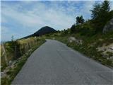 2
2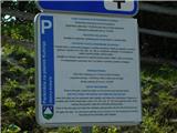 3
3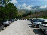 4
4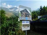 5
5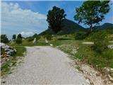 6
6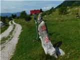 7
7 8
8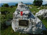 9
9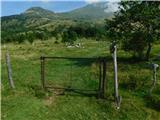 10
10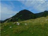 11
11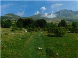 12
12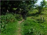 13
13 14
14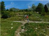 15
15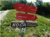 16
16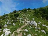 17
17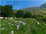 18
18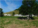 19
19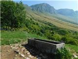 20
20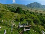 21
21 22
22 23
23 24
24 25
25 26
26 27
27 28
28 29
29 30
30 31
31 32
32 33
33 34
34 35
35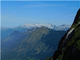 36
36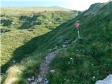 37
37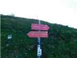 38
38 39
39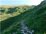 40
40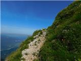 41
41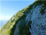 42
42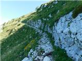 43
43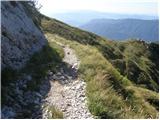 44
44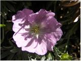 45
45 46
46 47
47 48
48 49
49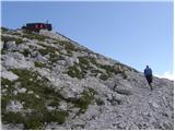 50
50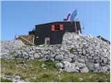 51
51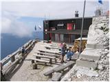 52
52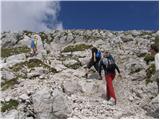 53
53 54
54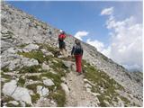 55
55 56
56
Discussion about the trip Planina Kuhinja - Krn
Show older messages
|
| bistri1. 09. 2006 |
31.8.06 It was a very nice day for a trip to Krn. The path isn't demanding with some fitness, but for us Gorenjci it's quite a long way to the starting point. Especially if road workers in Selška dolina detour past Bevkova domačija. True! One hour of extra driving on a road worse than many not even recommended for mountain starts. Tired from the three-hour drive (Slovenia isn't small) we reached the start only then. After one hour of hiking fatigue was gone. At the top the effort was richly rewarded. View from grintavci to the sea, from Snežnik to Hochschpitze and "marmelade". In between at least a hundred paragliders... Wonderful trip. Ahh - also: NO summit book or stamp on Krn summit.
|
|
|
|
| Gost4. 09. 2006 |
Don't worry about the stamp and the book, you know you have everything stored elsewhere .. you're smart
|
|
|
|
| Adson1. 11. 2006 |
THE REGISTRATION BOOK AND STAMP ARE IN GOMIŠČKOVO ZAVETIŠČE RIGHT BELOW THE SUMMIT, ON THE SUMMIT THERE IS A PLATEAU. When the hut is closed (closes end of September), there is an open bivouac with the registration book and stamp (the oval stamp for the traverse really isn't there then). Krn has one of the best views in the Julian Alps in good weather, but often gets foggy in the afternoon. I also recommend visiting neighboring Batognica, where the fiercest high-mountain battles of WWI took place, traces of which are still visible. Continue the tour to the lake in Lužnica and then to Planina Leskovca, from where you'll easily reach the parking lot on Planina Kuhinja.
|
|
|
|
| Gost31. 01. 2007 |
hello! I would just have one short question, in which month is it most pleasant to climb Krn, I also mean the beauty of flowers etc. the girls will go along too
|
|
|
|
| Gost1. 02. 2007 |
Plenty of flowers on Krn in June. Just know that the southern slopes of this mountain are very hot in that month. But if you set off at 5:00 from Planina Kuhinja it's ideal. You can admire the flowers on the way back.
|
|
|
|
| kRn7. 02. 2007 |
well, rarer flowers you won't find right along the path 
|
|
|
|
| Gost10. 06. 2007 |
There will be those babes along.... then there will be little flowers to admire   
|
|
|
|
| Gost10. 06. 2007 |
I prefer the term girls myself. Sometimes, when I go to the mountains with pleasant company, I don't even know where I've been, I was admiring the flowers. Otherwise, Krn is nice even without flowers and girls.
|
|
|
|
| Gost19. 08. 2007 |
How long does it take you to hike to Planina Kuhinja?
|
|
|
|
| Gost20. 08. 2007 |
Everyone should measure their own time.
|
|
|
|
| Gost21. 08. 2007 |
Theoretically 3 hours, but if flowers tempt you, even 5-6 hours, that's my pace
|
|
|
|
| Gost20. 09. 2007 |
yeah yeah some 3 hrs 15 I did it in 2 hrs 15 
|
|
|
|
| Gost21. 09. 2007 |
Yeah and!?
|
|
|
|
| Gost21. 09. 2007 |
Time is not important. What's important is reaching the summit with enough strength left for the return. Whether you take 1 hour or six hours up. Good luck!
|
|
|
|
| gaspell11. 11. 2007 |
I hiked to Krn in 3 hours from Kuhinja
|
|
|
|
| Nickster22. 07. 2008 |
Can someone tell what the conditions (winter) are
like for ascent to the summit?I mean especially avalanches and slips...
thanks for the reply!
lp
|
|
|
|
| benjamin77. 11. 2008 |
I'm curious how much time it would take for the descent via Batognica and past the lake in Lužnica to Planina Kuhinja. Thanks
|
|
|
|
| dede8516. 08. 2010 |
from Planina Kuhinja you have to puff quite a bit uphill, we reached the summit in 2 hours and 15 minutes
|
|
|
|
| JanaG27. 08. 2010 |
Yesterday from Planina Kuhinja to Krn, walking time with intermediate stops, photographing and two diligent boys (8 and 10 years) 4.5 hours. Return 2.5 hours (a bit longer stop at the raspberries)
|
|
|
|
| LukaSLO5. 09. 2010 |
Was there about 14 days ago on Krn via the described path. Tons of flowers, lots of raspberries. In short, gorgeous . From the summit, a wonderful view towards Krnsko jezero. But below the summit at the shelter there's quite a mess because they're renovating the bunks. A must-stop is also at Planina Zaslap, where you can refresh with excellent dairy products .
|
|
|
|
| akvarij11. 09. 2010 |
@JanaG, your comment contributed the most to our decision today to go to Krn with a very sporty 7-year-old and a somewhat rebellious 10-year-old. It took us exactly 4 hours up, and down (via Sedlo) also 2.5 hours.
Nice nice trip. The weather was also on our side.
|
|
|
|
| mikkeni3. 07. 2011 |
Hi, is the path to Krn accessible? Probably no problems on this path, what about other paths?
|
|
|
|
| rjudnic3. 07. 2011 |
I was up there two weeks ago and all paths from Kuhinja are normally passable. For access from Krnsko jezero winter gear is also needed, as there's still lots of snow on the path.
|
|
|
|
| mojcej'724. 07. 2011 |
On 2.7. we did the tour from Planina Kuhinja to Gomiščikovo zavetišče on Krn. Bypass the hut on Planina Kuhinja on the left and head up following the markers, cross the pasture, then the path is nicely marked. More or less it's such an idyllic ascent of about 1200m up and down on grass and nice path, among cows and sheep, which knows how to surprise, as at the "saddle" you already think you're quite close to the hut. But in reality you're just a bit over half. So you grind your knees a bit more, but then the views from the top make it all worthwhile. Otherwise botany on the path "rules" from white-yellow-pink-violet on, also to fragrant plants and rose hips. Rocks typical white limestone transitioning to Cenomanian-Turonian red and green shaly clays, higher up again some limestone and dolomite. In short, enjoyable. On Saturday incidentally some snowflakes fell as a sample, which further spiced up the otherwise wonderful day.
|
|
|
|
| bostjan2914. 12. 2011 |
11.12.2011. It seemed we would cancel the ascent to Krn again due to the poor forecast for Sunday afternoon, so considering my friend's suggestion for a night adventure was obvious. Italian meteorologists, who are more reliable for this area's weather, forecasted a clear night and, given the full moon without fog... poetry!!! The only concern was the amount of snow on the summit and whether it was frozen, as none of us (yet) has crampons or an ice axe.
We started from Planina Kuhinja at 2:15 a.m. The moon accompanied most of the ascent and headlamps were not needed yet. Somewhere at 1900 m we encountered a herd of sheep. Classic with sheep, they flee towards the peaks .
Our concern about the summit conditions was confirmed, and fog on top of that.... without crampons, it was impossible to continue! The summit will wait for another time . Consequently, we didn't reach the bivouac either, so we stopped and rested a bit in the "remains" of the Soča front. After resting, we headed back, met the sheep again, and since they had no business there at that time, we herded them to the barns. On the way, we met a local heading to Krn and also looking for lost sheep, who gave us some salt for easier sheep herding .
In short, a nice Sunday night and morning like we haven't had in a long time!
Yes, winter in the mountains is really beautiful, so I'm already looking for stiff boots, ice axe, and crampons . We'll learn to use them and happily into the snow .
Have a nice day and safe steps!
|
|
|
|
| Flora114. 12. 2011 |
Selling stiff boots for semi-automatic crampons, size 41, very lightly used, 5 tours, super condition. Too big for me.
|
|
|
|
| vik14. 12. 2011 |
Bostjan, we started exactly one hour after you from Planina Kuhinja on the left path via the SW ridge of Krn, to the hut, then to the summit. The last part really required crampons and ice axe. Then towards Batognica, but dense fog allowed no orientation anymore and we returned to the summit, then back the same way. It was closing in quickly behind us and it was already raining in Tolmin. More on the blog of the hike's idea leader - http://purchy-mylife.blogspot.com/2011/12/krn-2244m.html
|
|
|
|
| bostjan2915. 12. 2011 |
@Flora1: Unfortunately I need size 45. Thanks for the offer anyway.
@Vik: Then we saw you in the background with 3 lights!? Yes, with the fog it really became wintery! Otherwise, on the way down we met a local with interesting mustache, who gave us salt for the sheep and headed to the summit. Without crampons, but with an ice axe. He mumbled a bit that he doesn't need them, apparently a very regular visitor to Krn!
Regarding the blog: Very pleasant, easily readable and vivid path description!
|
|
|
|
| ales5015. 12. 2011 |
for the weekend I was thinking a bit about Batognica or even Koto 1313, if there would be too much snow up there, because I don't have modern crampons, only from the Soča front, and ice axe, I don't know what the equipment situation is like, lp
|
|
|
|
| Marky24. 01. 2012 |
Hello..
Has anyone been to Krn these days and how is the road to the starting point?
Thanks
|
|
|
|
| Člebek24. 01. 2012 |
The road to the parking lot at Planina Kuhinja is normally drivable, so there will be no problem.
Regards
|
|
|
|
| Marky24. 01. 2012 |
Thanks for the quick reply
|
|
|
|
| Marky25. 01. 2012 |
Irina, thanks for the info and contact..
|
|
|
|
| Irina25. 01. 2012 |
Marky 25.1.2012
Since you're also a fan of mountain photography, you'll get some inspiration from Miljko's photos.
Tomorrow will be a divine day for visiting the mountains, for those who have the knowledge and can take a day off. If you're one of them, enjoy and safe steps.
|
|
|
|
| IgorZlodej25. 01. 2012 |
But Miljko gets up very early, otherwise he wouldn't manage to take the photos he does, he's really good.
|
|
|
|
| Marky26. 01. 2012 |
Irina, unfortunately during the week the mountains are not accessible to me because of work 
But he really does great photos, just as Igor said, he gets up very early or goes to the mountains very late, which unfortunately I can't manage, because of the drive Maribor - ... But it'll be fine..
|
|
|
|
| Irina27. 01. 2012 |
Marky 26.1.2012
Poor consolation, but you're not the only one doing housework on nice days when your
thoughts wander to the mountains.
Yes, Miljko either doesn't go to sleep or gets up at the most impossible hours. The "reward" is of course accordingly. But it's true that for such ascents you need to be physically and mentally in top form. And of course have a lot of mountaineering knowledge and experience.
|
|
|
|
| ales5027. 01. 2012 |
To go to Krn in the snow you need to have experience, physical and above all mental fitness, of course you have to leave home early, depending on where you're from, in summer it's easier because there's no snow and you only need physical fitness and a bit of mental,
|
|
|
|
| _sandra_30. 01. 2012 |
Are 2 ice axes needed for the ascent from this side?
|
|
|
|
| ljubitelj gora30. 01. 2012 |
From Pl. Kuhinja crampons are needed, some have poles instead of an ice axe, others have an ice axe... from Krn Lake I didn't see that it was trodden to the saddle between Krn and Batognica.
|
|
|
|
| ljubitelj gora30. 01. 2012 |
...except two who went directly up from the north face of Krn
|
|
|
|
| Marky30. 01. 2012 |
The trail to Krn from Planina Kuhinja is ideal, but quite demanding in terms of fitness, as it keeps ascending continuously.. You see Gomiščkovo zavetišče the entire ascent, and it seems like you'll be there any moment, but nooo.. it's a good 3h ascent to get there..
Pictures of the ascent can be seen at M-foto.si
|
|
|
|
| katja8720. 02. 2012 |
I'm wondering if anyone has been to Krn recently and what the current conditions are on the Planina Kuhinja - Krn trail?
I'm planning to go on this trail next weekend and I'd like to know what the avalanche risk is like?
|
|
|
|
| katja8727. 02. 2012 |
On Saturday, February 25, 2012, we set off for Krn from Planina Kuhinja. The road to the planina is dry and therefore well drivable.
The weather was great, warm and windless, so it was really nice to enjoy the top.
There's still some snow towards the top, about a good meter. However, we had quite a few problems as the snow was wet and we sank frequently, even up to our waists at times. So this tour took quite a bit of energy and strength, but all the effort was rewarded at the top with a beautiful view
You can see pictures from the hike on the website of the Matica Murska Sobota Mountaineering Association: http://www.mojalbum.com/pdmaticams/20120225-krn-pl-kuhinja/pogled-proti-vrhu-krna/19466859
|
|
|
|
| _sandra_27. 03. 2012 |
Has anyone been to Krn from this direction recently? I'm interested in the conditions and how much snow is left?
|
|
|
|
| IgorZlodej27. 03. 2012 |
I haven't walked it, but I see it every day with sadness in my eyes, as there is practically no snow, conditions are completely spring-like, just some snow patches right below the summit.
|
|
|
|
| ibex28. 03. 2012 |
I was there last weekend (Planina Kuhinja - Krnska Škrbina), winter gear not needed except if you also go to Batognica where there is ice in places
|
|
|
|
| jedriličar29. 03. 2012 |
Has the hut at Planina Kuhinja opened? And if yes, does it operate weekends or only Sunday?
|
|
|
|
| ibex29. 03. 2012 |
I have no idea, it was a workday when I was there and it wasn't open
|
|
|
|
| ales5029. 03. 2012 |
everything is open, but you have to come at the right time,
|
|
|
|
| ibex29. 03. 2012 |
second time
|
|
|
|
| _sandra_1. 04. 2012 |
Yesterday, 31.3. I was on Krn, really no snow, just a little around the shelter and on the top. I also met a viper that was very loud
|
|
|
|
| ales501. 04. 2012 |
super, you only saw a viper, maybe an eagle too, hehe
|
|
|
|
| ales501. 04. 2012 |
super, you only saw a viper, maybe an eagle too, hehe
|
|
|
|
| _sandra_9. 04. 2012 |
yes aleš50, there were some eagles too
|
|
|
|
| Kokta18. 06. 2012 |
I just want to praise the caretakers for their hospitality and service. First league. Yes...we saw the eagle too
|
|
|
|
| tiasha9. 08. 2012 |
Looks like a very nice hike, gotta go is this path very steep?
|
|
|
|
| katty9. 08. 2012 |
The path is not steep, leads past the alpine pasture, then zigzags on a slightly wider path. More annoying is climbing the south side, meaning the sun beats down all the time. Therefore I recommend an early start.
|
|
|
|
| jana19669. 08. 2012 |
You can also make the route circular and set off from the parking lot right towards Planina Leskovca, via Lužnica through Batognica to Krn and return via Pl. Slapnik, it's only slightly longer, but extremely scenic - you won't regret it!
|
|
|
|
| slavko18. 08. 2012 |
Yesterday on Krn at 11.00. Ideal conditions, view into infinity.
|
|
|
|
| Nancy19. 08. 2012 |
hi, can anyone advise which path is best if I want to see (up close ) also Krnsko jezero? thanks and happy trails!
|
|
|
|
| ales5019. 08. 2012 |
I can be your guide if you want,,I know every hole there,
|
|
|
|
| Grega198323. 01. 2013 |
Krn - my favorite mountain in Slovenia. The view from this weekend on Krn is really phenomenal. Personally recommend driving by car to Planina Kuhinja where you can refresh yourselves, then go up the "plateau" to the summit. Usually takes me 3 hours to the top, the path is not demanding. Highly recommend, the trip will be perfect Best regards
|
|
|
|
| pirseb2426. 04. 2013 |
Hello
I'm interested if anyone has been to Krn recently and what the conditions are like. Is there still a lot of snow, are crampons needed?
Thanks for your answers
Best regards
|
|
|
|
| ZoranV26. 04. 2013 |
A very warm day was forecast but the snow was hard in the morning and walking was a real pleasure. At the top, a view you can't get enough of. I did two descents, the first to the edge of the snow line and back to the top where I just caught my one who arrived at the top. The second time the snow was much better and I descended into the gully under Batagonica and along the snow river even further towards Planina Kuhinja. That would have been the end of a perfect day, if Krn hadn't shown its teeth to my Sandra, who went down on foot, showing that it's no joke. Deep below the snow line, already half an hour of walking on grass, she reached a snow tongue and stepped too confidently and slid 15 meters on the snow and over some rocks ... luckily it ended only with bruises and scratches. Every lesson costs something.
Some snapshots in the video.
http://www.youtube.com/watch?v=QkhhUpK4L5E
For all who weren't up there on Wednesday, a 360 panorama. On first visit it opens a test panorama so click test or skip below and Krn will show up.
http://pan0.net/upano.php?id=4835
|
|
|
|
| katja876. 05. 2013 |
On May 1st we headed to the summit of Krn. The day was nice, although it looked rather bad in the morning.
Most of the path is bare, so snow doesn't cause problems. Only the summit is snowy, where you need to be quite careful and not go to the edge, as there's a significant drop.
The views were magnificent and it was quite interesting to look to the other side towards Krnsko jezero, as it's like seeing a completely different world ... everything is snowy, so only enthusiastic ski tourers came from that side.
Photos from the hike can be viewed on the website of Planinsko društvo Matica Murska Sobota: http://www.mojalbum.com/pdmaticams/20130501-krn-iz-planine-kuhinja/krn/20746668
|
|
|
|
| Laščan13. 07. 2013 |
On the ascent to Krn, I would like to also visit the Italian chapel Bes on Planica. How much time is needed for that and is the junction to the approach marked somewhere? Any information is welcome. Thanks and best regards!
|
|
|
|
| Lj13. 07. 2013 |
I was there four years ago: from Planina Kuhinja along the path to Krn, above Kuhinja turn left to the chapel. The junction was marked with a pole like those on the Walk of Peace. I don't remember if it said chapel or Planica... a bit up, a bit down... walk for about an hour or less for the faster ones.
|
|
|
|
| Laščan14. 07. 2013 |
@Lj and @Tolminc, thanks!
|
|
|
|
| valerija11227. 07. 2013 |
Hello! If anyone hiked today (27.7.) from Planina Kuhinja to Krn, please reply. I'm wondering if the heat is still within limits where hiking is still enjoyable. Thanks in advance.
|
|
|
|
| _sandra_27. 07. 2013 |
start very early, and it will be enjoyable for you during the day it's normal that it's very hot, especially from Planina Kuhinja...
|
|
|
|
| jax27. 07. 2013 |
One hundred people, one hundred opinions. But this trail in such weather I REALLY do not recommend.
|
|
|
|
| nanica29. 07. 2013 |
On Krn on 27.7. Ascent past Jezero in Lužnica and over Bagotnica (wonderful path). At the top of Krn incredibly hot (thermometer showed 24 degrees at 14:00)
A chapter of its own was the descent towards Planina Kuhinja. The heat was infernal, radiating from the hot ground, the descent is quite long, and the heat gets worse with every step lower. We met a larger group of Prekmurci climbing in the worst afternoon heat, and some visibly exhausted asked how much further to the top (maybe one of them could share their experience)
To be clear: we were prepared for the situation, we had plenty of time, strength and drinks. But I'm convinced that severe heat can greatly reduce the enjoyment of the tour.
|
|
|
|
| valerija11229. 07. 2013 |
Thanks for the answers and comments. We postponed the visit to Krn to cooler days, yesterday we visited Soteska Pekel near Borovnica. If you haven't been there yet, now is the right time. Best regards.
|
|
|
|
| repika30. 07. 2013 |
It's really hot; we also went family-style to Krn a few days before you and were already up early in the morning. But that damn steep path down to Planina Kuhinja really wore us out precisely because of the heat. And we were well prepared. Nevertheless, we'll visit it again because it's worth the effort and the view.
|
|
|
|
| Miha_31. 07. 2013 |
28.7. severe heat forecasted in valley. Start from pl. Kuhinja at 6:00, via Krnske škrbine to summit. At shelter 13 degrees, and windy, so need fleece.
Of course, halfway down enter cauldron, severe heat to start point.
|
|
|
|
| Bandzo19. 08. 2013 |
15.8.2013 went on this path to Krn, otherwise later start due to a very cold day the previous day, but it warmed up quite a bit. Pleasant hike, where sunscreen must not be missing.
|
|
|
|
| Ivanka16. 09. 2013 |
On 14.09.2013, my colleague and I set off for Krn. Even though I had a printed route description from this site with me, we missed the spot on the path where there's an unmarked junction left to Krn and right to Krnska škrbina (photo no. 16) and of course we went towards the škrbina instead of left up. When we reached the škrbina, we headed left up towards the summit of Krn, but we got too scared looking left down and decided to return the same way. On the way back, we of course noticed (because we had seen people) where we had gone wrong. Out of the same fear, we then headed up that path again towards the ridge and onwards to the summit of Krn. Our ascent to Krn thus took not 3.5 hours but a full 6 hours ... and of course then the descent took another 2.5 hours.
Because on the way back I talked to a few friends who had gone up the same path, several of them said they had also gone wrong at that unmarked junction.
At this point I ask: Why isn't such an important junction marked?
|
|
|
|
| miri16. 09. 2013 |
@Ivanka, was there fog, because otherwise there shouldn't have been any problems?
|
|
|
|
| gorolazka16. 09. 2013 |
The problems are greater if you also go to Batognica and past the lake in Lužnica to Planina Kuhinja. There you can easily get lost especially in fog...
|
|
|
|
| Ivanka18. 09. 2013 |
Miri, it wasn't fog ... but still I think that at that point a signpost is missing ... In this time since I wrote the previous post I talked to quite a few acquaintances who admitted they missed the same point ....
|
|
|
|
| valerija11218. 09. 2013 |
We too missed that less visible junction at the beginning of August. However, we found out that we were rewarded for that on the path from the saddle towards the hut with unforgettable views. Time-wise it wasn't that bad either. From Kuhinja to the hut we walked 3 hours and 45 minutes, and we're slower. Best regards.
|
|
|
|
| B218. 09. 2013 |
I'm very surprised how it's possible to go astray "on mown ground". We have the hut below the summit in sight the whole ascent and Krn is full of mule tracks that all lead towards the summit - the hut! Even if we "cut across" directly towards the hut we don't miss anything and every fifty meters of altitude we run into some trace of a mule track...
|
|
|
|
| Ruzowski14. 03. 2014 |
Has anyone been to Krn from Kuhinja? Is there snow up to the hut, is the path passable?
tnx
|
|
|
|
| Shuensha5. 08. 2014 |
I'm curious how much livestock there is on this trail.... I see it goes through pastures but is a large part of the trail like that? I'll have two dogs with me, of course I'll have them on a leash but they are still a bit restless.
|
|
|
|
| miri5. 08. 2014 |
If you can't control them, it's better to choose another tour.
|
|
|
|
| Becar5. 08. 2014 |
There is quite a lot of livestock, in July cows were right on the trail, so I also advise against it.
|
|
|
|
| Shuensha6. 08. 2014 |
It's not that I don't know how to control them, both dogs are trained. Velika is calm, Tamal knows how to bark a little when he's afraid of cows there aren't pastures all the way to the top, right?
|
|
|
|
| Alfista6. 08. 2014 |
Pastures from the hut 1000m to the last pasture Zaslap and a bit higher, so at your discretion. At least on a leash, if there are cows on the path then better a proper detour.
|
|
|
|
| Shuensha6. 08. 2014 |
Well, wherever I go at this time there are pastures.... so we'll just nicely go to Krn on Sunday, we'll avoid the little cows so they can graze in peace
|
|
|
|
| miri6. 08. 2014 |
And why did you ask for advice?
|
|
|
|
| Shuensha7. 08. 2014 |
And I can't ask?!?! If something doesn't suit you, you don't have to answer!!
|
|
|
|
| tulipan7. 08. 2014 |
Shuensha!
On Monday, delight us with a report, and a picture of your dogs too!
|
|
|
|
| valerija1127. 08. 2014 |
Tulipan, bravo for positive thoughts!!! Shuensha, good luck on the way. I hiked it last year, unforgettable.
|
|
|
|
| Shuensha7. 08. 2014 |
Thanks thanks.... of course there will be pictures
|
|
|
|
| Shuensha7. 08. 2014 |
The destination remains the same but we will take a different route, namely from Lepena past Krnsko jezero. And apparently the weather forecast indicates that we will have to start on Saturday
|
|
|
|
| tulipan7. 08. 2014 |
In the Koča pri Krnskih jezerih, greet Cveta Hvala on my behalf!
|
|
|
|
| valerija1127. 08. 2014 |
This path is longer, but also very beautiful. Enjoyment, the little dogs will be satisfied too.
|
|
|
|
| ToniŠentjur8. 08. 2014 |
I was on Krn on Wednesday 6.8. and it was fantastic! Super view from the top...
|
|
|
|
| kanin44425. 08. 2014 |
Does anyone know until when Gomiškovo zavetišče is open?
|
|
|
|
| lučo15. 09. 2014 |
yesterday very nice tour: pl.Kuhinja-Krn-Batognica-Lužnica-pl.Leskovca-pl.Kuhinja; Gominško zavetišče is no longer serviced, only "winter room"
|
|
|
|
| lojz16. 09. 2014 |
Are Krn and Batognica also snowy or the path around Batognica?
|
|
|
|
| ejas123414. 10. 2014 |
If anyone has been to Krn recently, I'd appreciate a description of the conditions. Thanks.
|
|
|
|
| naroblek27. 10. 2014 |
I'm heading to Krn and since the Gomiščk shelter on Krn is closed, I'm interested if it's possible to get the SPP stamp at the summit or at the hut? Thanks.
|
|
|
|
| pikica127. 10. 2014 |
The Gomiščk shelter has a winter room that is open. Inside on the table there is the logbook and the Krn summit stamp, the Gomiščk shelter stamp and the PD Nova Gorica stamp.
|
|
|
|
| naroblek27. 10. 2014 |
Thanks for the quick reply.
|
|
|
|
| Janiel7428. 10. 2014 |
Does anyone know the current conditions on this path? Snow?
|
|
|
|
| julika28. 10. 2014 |
From Planina Kuhinja the path is dry
|
|
|
|
| Janiel7428. 10. 2014 |
Thanks for the info
|
|
|
|
| Nina Špik3. 11. 2015 |
Hello. Has anyone been recently to Krn from Planina Kuhinja? Is there any snow?
|
|
|
|
| Tolminc3. 11. 2015 |
Nina, from Planina Kuhinja the path is dry. The days are wonderful, so go happily good luck!!!
|
|
|
|
| Nina Špik3. 11. 2015 |
super thanks for the info.
|
|
|
|
| franjo6629. 12. 2015 |
Has anyone been walking here these days? And what are the conditions
LP
|
|
|
|
| nickolas1629. 12. 2015 |
Grey-green grass, stones, trees without leaves.
This is the southern path, a month without precipitation always sunlit. What will it be
|
|
|
|
| zivljenje je lepo30. 12. 2015 |
End of December the conditions on this path were almost summery. We were here yesterday (29 December), dressed only in long-sleeved t-shirts, the sun warmed us intensely. Nowhere on the path any snow or ice, the path is really completely undemanding, suitable for any child if it has stamina. Two hours 50 minutes to the shelter with slow continuous walking. Take enough water with you, I recommend 2 liters per adult person, because the sun really makes you thirsty.
|
|
|
|
| franjo6630. 12. 2015 |
IS GOMIŠČKOVO SHELTER ON KRN
OPEN FROM THE OLD YEAR INTO THE NEW YEAR
BECAUSE WE PLAN TO CELEBRATE NEW YEAR ON TOP OF KRN
|
|
|
|
| Smetar30. 12. 2015 |
If the hut isn't operating, the bivouac will surely be open... given the conditions, you'll probably not be quite alone
|
|
|
|
| Stasa9231. 12. 2015 |
We were on Krn on Saturday.. the hut is CLOSED, only the bivouac is open, LP
|
|
|
|
| franjo6631. 12. 2015 |
Thanks for the info.
|
|
|
|
| majastop29. 12. 2016 |
path beautiful, sunny and passable. hut below is closed, no snow
|
|
|
|
| Pelca19. 07. 2017 |
Would someone who has problems crossing steep slopes have difficulties on this path, e.g. on Begunjščica from Robleka or Veliki vrh from Kofce?
|
|
|
|
| Pelca19. 07. 2017 |
Thanks for the answer. Do you perhaps know if it's easier from the north side, from Krnsko jezero?
|
|
|
|
| ljubitelj gora19. 07. 2017 |
The path from Planina Kuhinja is easy, via Krnsko jezero it's long and strenuous for 1 day. If you're going these days you need to start very early.
|
|
|
|
| Janez Seliškar19. 07. 2017 |
Regarding crossing steep slopes it's easier, but longer. It's smart to arrive at Dom pri Krnskih jezerih in the afternoon the first day, overnight and set off towards the summit very early the next morning (before 6).
|
|
|
|
| slimat4. 08. 2017 |
Can one get from Planina Kuhinja to Krnska jezera in the afternoon, how much time is needed for that? Then I would overnight, the next day to Krn and back to Planina Kuhinja; if anyone can give info I'll be glad, thanks and lots of hiking pleasures
|
|
|
|
| valerija1124. 08. 2017 |
Have you looked at the map? From Planina Kuhinja to Krnska jezera you go almost over Krn. Do you know any other path? And in this heat don't start in the afternoon from Planina Kuhinja!
|
|
|
|
| valerija1124. 08. 2017 |
Why not go from Lepena? There to the lake it's mostly through forest. Look a bit higher at Janez Seliškar's answer. Choose a tour and enjoy.
|
|
|
|
| slimat5. 08. 2017 |
Thanks for the answers and suggestions.
I'll choose another starting point because I definitely want to reach the lake, best regards
|
|
|
|
| gmckmck14. 05. 2018 |
Hello,
is there still any snow on the trail from Planina Kuhinja to Krn? I plan to go up this Saturday.
|
|
|
|
| ksena14. 05. 2018 |
There's no snow at all to the hut, from the hut to the summit just a few tiny patches. Good luck!
|
|
|
|
| mirko117. 06. 2018 |
in these days I was several times on Krn, still at the starting point it says the hut is open. well, it's still closed. today there were around 200 hikers on the path. for me the Krn season is slowly ending because it's getting too hot. now they can slowly open the hut too.
as for conditions, no snow anywhere, also ahead Batognica, Peske, Škofičevo... good luck
|
|
|
|
| mirank17. 06. 2018 |
Isn't "hut open" meant for the one on Planina Kuhinja? Last week I wasn't paying attention to it, and anyway I don't stop at huts very often, so neither one nor the other interested me.
|
|
|
|
| ajo6217. 06. 2018 |
Always the same old problems, really sad, the summit of Krn which receives the most massive visits precisely in late spring, in May and especially in June, then in October and November. And just then the hut is closed... No comment.. regardless of whether certain hikers are interested in visiting the hut or not. Sometimes it seems to me that time has stopped in the 80s in many places here.. and probably there's no intention to change.
|
|
|
|
| darinka418. 06. 2018 |
They are preparing. Lightning destroyed their water tank. And they probably need to get a new one. From what I heard, the shelter will be open only on weekends, unless they decide otherwise. Really a pity that it's like this.
|
|
|
|
| miratan10. 01. 2019 |
Hello,
has anyone been to Krn in the last few days? Is winter gear needed?
|
|
|
|
| darinka410. 01. 2019 |
Better take it just in case.
|
|
|
|
| mornar24. 06. 2019 |
Has anyone been to Krn past the lake in Lužnica, what's the path like via Batognica and where is the stamp at Gomilškovem zavetišču. Best regards and thanks for the reply.
|
|
|
|
| mirank24. 06. 2019 |
We descended down there and already 14 days ago there were no problems with snow or what interests you? Gomiščkovo zavetišče should be open, if not the book is in the bivouac so I see no problems, just start early enough on the path ...
|
|
|
|
| britof11. 11. 2019 |
10.11.2019, a wonderful Sunday morning that smelled more of early spring than the beginning of winter which started showing its teeth 500m higher, wildlife still persisting at the foot of Krn, Batognice grazing in the pleasant sunshine.
With a friend, equipped with all winter gear although we didn't need it as the track although narrow in places was already made, we slowly trudged towards the summit, snow increasing meter by meter, near the summit almost a meter, easy without crampons. Weather pure poetry as one could wish, views magnificent unforgettable.
|
|
|
|
| ljubitelj gora4. 12. 2019 |
Today 4.12.2019 to Krn from pl.Kuhinja, winter gear is mandatory, as the snow was quite hard and without crampons you can't get very high.
|
|
|
|
| darinka45. 12. 2019 |
We two also thought we'd have a hard base all the way to the hut. But before noon, while walking on the slabs there, the sun softened the snow and snowballs formed on the crampons. The last part had to be done carefully and it takes a bit more time.
|
|
|
|
| lukna6. 02. 2021 |
What are the conditions like on Krn?
|
|
|
|
| jax6. 02. 2021 |
In my opinion, awful. Like almost everywhere this winter.
|
|
|
|
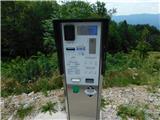
| ljubitelj gora6. 08. 2021 21:15:57 |
Parking for the whole day at this parking lot is 10 euros. Valid from 6.8.2021.... 100m further at the hut there is free parking.
|
|
|
|
| link_12. 08. 2021 17:58:16 |
Today there were all sorts of people on Krn. Please, don't cut corners on the slab between switchbacks, it's very dangerous.
|
|
|
|
| darinka423. 08. 2021 07:52:00 |
Pleasant trip yesterday on Sunday along Krnska plošča. Many cars parked at the parking area and also at the hut. And also along the road. But in the future it probably won't be like that anymore. I think many will turn back. Because, as I heard, they are going to install a barrier-ramp. And parking fee 10 euros for everyone the same. Apparently the mayor was at the top of Krn yesterday. We'll have to choose other paths. This is the future. Barriers everywhere. They have very good skuta at Planina Leskovca. I bought it last time too. And now again. And they are friendly there. Now they have also put up a traffic sign lower down before the side parking areas on the road. And you can pay with phones as in Zadnjica.
|
|
|
|
| tavzentroza23. 08. 2021 20:19:56 |
I went to Planina Kuhinja with the on-off bus from Kobarid. The driver had to avoid all vehicles coming down from the planina. Difficult drive. They could put up a sign that during the time the bus is going up, traffic is closed for other vehicles. Otherwise, all the idyll around the hut is spoiled by these numerous vehicles. The bus ride is for 2€.
|
|
|
|
| ljubitelj gora23. 08. 2021 21:03:25 |
They just got on the green branch to attract people to that corner, now with this 10 euro parking lot they'll drive some away too. The park fee will apparently be collected by the municipality, which isn't so bad since they'll invest back into the Kobarid municipality. But locals involved in tourism might suffer a bit. Or maybe not, depending on how they've planned sales of local products, produce....
|
|
|
|
| darinka423. 08. 2021 21:11:37 |
I think someone will burn their clutch meeting this bus in the steep section of the road. No place to pull over. And what I saw, the bus is already quite battered. This road is suitable for passenger vehicles. It was already closed for quite a while when they were laying electricity to install parking meters and more. As far as I remember there were never issues with parking or driving. Not even in summer. Anyway now parking is along the road. If they put up a barrier right after the last house they'll have golden peace as far as noise goes. Then they can close the hut too. The other day an Italian hiker returning from Krn said he comes once a week. Always leaves his vehicle at the hut. And on descent goes to the hut for lunch.
|
|
|
|
| tavzentroza24. 08. 2021 08:50:39 |
Traffic should be regulated so that during the bus ride up that slope which lasts about 15 min, traffic for other vehicles is limited/stopped. Already suggested above.
|
|
|
|
| ljubitelj gora24. 08. 2021 11:44:24 |
You're kidding . Close a public road so the bus can drive. What about locals, landowners. The bus has no business there, endangering others who have to pull over, drive back. Just so one veers off somewhere and overturns then they'll sweep it under the rug again. In the end we're not welcome there anymore and most don't want to meet that bus on such a narrow road. The smart ones will go elsewhere, that fits into tour planning that starts from the home doorstep onwards....----> . Close a public road so the bus can drive. What about locals, landowners. The bus has no business there, endangering others who have to pull over, drive back. Just so one veers off somewhere and overturns then they'll sweep it under the rug again. In the end we're not welcome there anymore and most don't want to meet that bus on such a narrow road. The smart ones will go elsewhere, that fits into tour planning that starts from the home doorstep onwards....---->
|
|
|
|
| 12a3bc12. 10. 2021 17:20:20 |
In the village Vrstno there is a sign for complete road closure because they often repair higher up but on Sunday it was possible to pass by. Don't know how it is during the week.
|
|
|
|
| darinka43. 01. 2022 14:57:33 |
There at the parking lot on Planina Kuhinja, a sign was posted in December prohibiting parking for all vehicles along the lower road. Yesterday, this sign was turned towards the village prohibiting parking for vehicles 500 meters ahead from the parking lot. Even now when it's not the season and no parking fee is charged. From November to the end of March. I didn't see the parking meter though. Probably they took it down to the valley. And they'll bring it back in April. Whether they'll really install a barrier, as I heard. I think it will deter many people from visiting Krn from this side. Otherwise, there are other approaches in the summer time and there won't be problems because of that.
|
|
|
|
| padez3. 01. 2022 16:50:46 |
Eh, even the locals have had enough of this traffic, from which they get nothing but annoyance when meeting on that narrow road...
The turned sign would say it's a consequence of what I wrote before...
|
|
|
|
| darinka43. 01. 2022 17:27:18 |
Yesterday I didn't meet a single vehicle on the road from Kamno to the village of Krn. Not even on departure. I think the municipal councilors who don't live in the village have a say here. With the locals, I really don't remember ever having problems.
|
|
|
|
| margu504. 01. 2022 12:05:06 |
Doesn't the PD have any say in this? Who owns the Koča na Planini Kuhinja? Transport roads are also part of tourism development, they should copy good experiences from neighbors.
|
|
|
|
| mirank4. 01. 2022 17:13:39 |
The hut belongs to PD Kobarid, you don't feel the inhabitants of the village Krn as you don't see anyone anywhere. And I don't even know if there are more than 30 in total.
|
|
|
|
| winni5. 01. 2022 09:53:34 |
The road is still in a desperate state, but the important thing is to collect parking fees first. Abroad it's different: first things are fixed, then visitors are appropriately charged.
|
|
|
|
| capraibex5. 01. 2022 23:00:54 |
Lately, practically all important accesses for longer tours are being closed, fines are being issued everywhere, public transport in summer is poorly organized. Also, locals often behave arrogantly towards hikers, closing public roads or expecting monetary compensation for passage. Unprecedented chaos. About specific cases some other time.
|
|
|
|
| jax6. 01. 2022 08:55:58 |
Oh, just by the way: what is so desperate about the road to Kuhinja?
|
|
|
|
| mirank6. 01. 2022 16:54:10 |
Well, I was there on the 30th and I have to say the road is quite well maintained. The section to the village Krn, where the embankment was slipping and it seemed everything would slide towards Gregorčičev slap, is reinforced and resurfaced. New surface also from the last house to the parking. That it's narrow overall is known, and you need to be careful at rare encounters! Currently the worst road section is right after the village Kamna.
|
|
|
|
| darinka430. 01. 2022 21:52:15 |
Today I saw that they will repair the road, that part which is subsiding from Kamnega towards Vrsnem. It says there will be a complete closure.
|
|
|
|
| darinka413. 02. 2022 19:45:49 |
Beautiful day today on Krn. A bit windy though. And about minus 5 at the top. Only acquaintances were up there today. Crampons needed from the hut to the top. And also on descent as long as there is snow. We were all properly equipped, which is right.
|
|
|
|
| mirank13. 02. 2022 20:18:23 |
The Kamno-Vrsno road is being repaired; complete closure on weekdays during working hours. Open for passage during lunch time.
|
|
|
|
| darinka428. 11. 2022 07:58:38 |
Yesterday, from what I saw, they started works from the hut along the path, they will pull electricity to the pastures. I already thought there would be a cable car to Krn. Once it was routed from Kožljak to Krn. Regarding the parking lot, the mayor is to blame. He wanted it that way. The barrier is not yet active. But it's installed. From what I heard yesterday, they plan to activate it next year. Hikers are supposed to buy the ticket probably somewhere down in the valley. They say they earned too little from collecting parking fees. Now they will earn more. You could park for free at the hut anyway. This will deter many from visiting Krn and other peaks. They were arranging the winter room in the shelter. Because of the gale-force wind in the previous days, it opened the door and they had to remove all the snow. Now they've fixed everything. They put shutters and fixed the doors that open in the upper part. It would be nice if everyone cleaned up after themselves and of course closed the doors when leaving.
|
|
|
|
| ljubitelj gora28. 11. 2022 21:03:37 |
No barrier, no parking meter anymore... unless someone damaged it and they removed it.
|
|
|
|
| Mojca19. 12. 2022 16:09:42 |
I was there alone on 30.10. and the sign said parking is paid from 1.4. to 31.10., so they probably removed the parking meter until spring.
I contacted PD Kobarid and they have nothing to do with it. The Kobariški mayor decided on this parking meter, who said, quoting: "Our municipality has decided to regulate the parking regime in the Planina Kuhinja area and consequently the parking lot has become paid."
I'm wondering, if I arrive at Planina Kuhinja before 8 a.m. (from 8 a.m. onwards parking fee is required) and if all free parking spaces at the hut are occupied, is it enough to set the arrival time on the parking meter to avoid a fine (probably not small)? Thanks for the answer.
|
|
|
|
| darinka419. 12. 2022 20:04:32 |
Just the other day when I was returning from Krn, I was talking with two familiar hikers about the parking fee. That they didn't earn enough from parking. That's why they are supposed to install a barrier next year. And those who want to go to the mountains from this side would probably buy a ticket in the valley. Then I noticed that the barrier is supposed to be in Vrsnem. Which is unusual. Anyway, we'll see, said the blind one. It will deter many people. Or not.....
|
|
|
|
| BT8820. 12. 2022 08:07:45 |
Let them put barriers right in Tolmin.
|
|
|
|
| jax20. 12. 2022 08:14:38 |
Making access to the village where people live paid, I think that's a new peak. Well, let's wait.
|
|
|
|
| mirank20. 12. 2022 20:25:30 |
The foundation for the barrier is in the middle of the road right after the last left bend before the parking. It's been like that since autumn, I don't believe they will close the path lower down.
|
|
|
|
| pepč21. 12. 2022 14:05:30 |
This is part of the arrangement of the alpine pastures under Krn. On Planina Zaslap and Slapnik they are arranging communal infrastructure, such equipped buildings will be touristy, but above all commercially interesting. I would like to know what the official opinion of TNP is, I hope the documentation will be publicly available someday. The mountains, especially TNP, are becoming accessible only to the rich.
|
|
|
|
| darinka421. 12. 2022 15:14:52 |
Last time everything was dug up towards Planina Zaslap. Right next to the alpine path.
|
|
|
|
| mirank21. 12. 2022 15:35:32 |
Those who want to see how pastures are managed should go look elsewhere, no need to go far since it's already much better in Gorenjska. Pastures in Posočje look as if brought by a flood. Just tidying the surroundings doesn't require major actions. If TNP demands ruins, authentic rusted sheets, nettles... remain and no access anywhere unless paid, then it can be discontinued for all I care.
|
|
|
|
| padez21. 12. 2022 16:22:28 |
Yes, and the "headquarters" of TNP is in Bled. That says something too...
|
|
|
|
| Mojca25. 04. 2023 21:28:33 |
|
|
|
|
| Mojca25. 04. 2023 21:28:47 |
|
|
|
|
| Mojca25. 04. 2023 21:29:03 |
|
|
|
|
| winni10. 09. 2023 08:03:13 |
After what I saw today, I quite agree with introducing the parking fee, the parking lot was packed with LJ-plated cars.
You don't get free parking in Ljubljana anymore either, so it's only right that they return at least something
|
|
|
|
| georgia10. 09. 2023 21:00:07 |
Since when is everyone with a Ljubljana license plate a Ljubljanan? My husband and I are both from Gorenjska, but we also have cars with those plates. My previous car even had Maribor ones!  The cars were bought used and the plates stayed the same up there. The cars were bought used and the plates stayed the same up there.
So no generalizing, please, probably many people at that parking lot weren't even from Ljubljana!
|
|
|
|
| Evjuna11. 09. 2023 07:14:00 |
Yeah, but is there anything wrong with being a Ljubljanan?!
|
|
|
|
| mikkeni27. 01. 2024 11:32:06 |
Has anyone gone to Krn and Kuhinja in the last few days?
|
|
|
|
| maartin20. 07. 2024 16:51:30 |
Returning after a full-day tour over Krn to Kuhinja is quite brutal, no shelter and very monotonous walking.
Whoever uses the free bus should be a bit careful, because last week it was a van for 8 people, luckily there were only 5 of us for the last slot, but it could easily happen that you get stuck up there. Otherwise, demand for such transport is low this year.
|
|
|
|
| mirank8. 01. 2025 14:35:11 |
The above description is not quite accurate; the unmarked junction in picture 16 is a shortcut to the Krn trail, which has been the most used in recent years. It is true that a little higher it crosses the mulatiero that leads right up to Krnska škrbina. When the path crosses the mentioned mulatiero, after a short flat traverse of the slope, it joins the marked path to the shelter. Pictures 19 and 22 are identical - this is the junction of the trail to Pot Silva Korena, which is located 12 switchbacks higher.
|
|
|
|
| Tadej11. 01. 2025 09:19:56 |
Thanks for the warning. I changed it in the description.
|
|
|
|
| NEIC00826. 06. 2025 12:56:13 |
I'm wondering if it's possible to return via Dom pri Krnskih jezerih and then back to the starting point Planina Kuhinja?
|
|
|
|
| mirank26. 06. 2025 13:46:29 |
Everything is possible, but you have to take into account the descent from the summit 1000m to the hut and then the ascent back to Krnsko škrbino, which amounts to about 800m of ascent.
|
|
|
|
| NEIC00826. 06. 2025 14:52:08 |
@mirank thanks but I don't know why you'd go back to Krnsko škrbino? I think it's not necessary, or am I wrong?
|
|
|
|
| DVas26. 06. 2025 15:23:37 |
Of course you have to go back to the škrbina. All other variants are too long.
|
|
|
|
| mirank26. 06. 2025 17:04:49 |
Yes, the variant via Prag and dolina Lužnice is certainly at least an hour longer and with practically the same elevation differences.
|
|
|
|
| GregaČ1. 07. 2025 00:05:08 |
We went on Sunday 29.6.25. It was a hot sunny day so we hardly met anyone, but there were some clouds right over Krn, so we walked 3/4 of the path nicely in the shade Which was just perfect, because otherwise it would be really intense sun on this path - it's a very sunny exposed path (south direction), so sunscreen is mandatory, as well as a hat that covers the neck and enough water. We parked at the parking lot on the planina (10€ for the whole day, free up to 2h), then 5min walk to the hut, where they were extremely friendly. Three elderly ladies were working, who were as friendly as mothers themselves, we felt at home Then 3.5h walk to the summit. The path is beautiful, scenic, gradual, so no issues. On the way lots of different flowers and butterflies (literally) it was a real pleasure to walk and observe all the life around. At the summit in the shelter there was fog, so we didn't get the views. The caretaker said it's often cloudy around the peak around noon, clear views are more in the morning and late afternoon (when he showed us pictures from his mobile). About 50 cows were grazing on the slopes of Krn, so it was nicely ringing along the path. When we got back down to Koča na planini Kuhinja, we showered (possible, 3€, but sooo worth it....then at home just fell asleep ). Kuhinja (literally I mean) operates until 20h, so we also had a jota and headed home. We recommend - nice and pleasant ascent.
|
|
|
|
| jprim1. 07. 2025 15:04:35 |
Nicely presented, but still, isn't it nicer to hear or read elderly ladies rather than old ones.
We never know how old we will be.
Best regards!
|
|
|
|
| remusovpulover18. 04. 2026 17:58:08 |
Does anyone know when the parking fee at Planina Kuhinja started/will start? Thanks.
|
|
|
|
| darinka418. 04. 2026 18:08:11 |
I think, if nothing has changed, the barrier has been lowered since April. Otherwise, someone who was up there these days will know more accurately.
|
|
|
|
| darinka418. 04. 2026 18:51:59 |
It's chargeable. I just found out.
|
|
|
To post a comment you must log in:
If you do not yet have a username, you must first
register.