Planina Loka - Velika Raduha
Starting point: Planina Loka (1435 m)
| Latitude/Longitude: | 46,40340°N 14,75730°E |
| |
Walking time: 1 h 55 min
Difficulty: easy marked way
Elevation gain: 627 m
Elevation difference along the route: 645 m
Map: Kamniške in Savinjske Alpe 1:50.000
Recommended equipment (summer):
Recommended equipment (winter): ice axe, crampons
Views: 274.657
 | 16 people like this post |
Access to starting point:
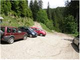
From Mozirje we drive towards Logarska dolina, but only to the village Struge (village between Ljubno and Luče), where signs for Snežna jama on Raduha point us to the right onto a narrower ascending road. The mentioned road, which has a few crossroads, we follow in the direction of Snežna jama and mountain hut Koča na Loki (crossroads are well marked). After 16 km (of which 9 km macadam) of driving from the spot where we left the main road, we come to the starting point, where we park near a smaller crossroads (by the crossroads there are signposts for mountain hut Koča na Loki).
Route description:
By the parking lot we notice hiking signposts for mountain hut Koča na Loki and Raduha, which point us onto a rough forest road which ascends through a strip of forest. Already after a few dozen steps of walking, we step out of the forest onto the lower part of mountain pasture Loka. We continue the ascent on a relatively steep road, along which in a few minutes we ascend to the hut Koča na Loki.
From the hut we continue on a marked path in the direction of Raduha, which already after a few dozen steps splits into two parts. We continue slightly left (slightly right Durce) on the path, which gently ascends along the left edge of the small valley. The path soon turns left and steeply ascends through a strip of sparse forest. The steepness soon eases, and the path leads us through a few smaller meadows into a belt of dwarf pines, where it continues moderately to occasionally steeply ascending. After approximately one hour of walking from Koča na Loki, the path from Durce joins from the right, and we continue left on the traversing path in the direction of Raduha. An increasingly scenic path bypasses the summit of Mala Raduha on the south side, then brings us to the main ridge, from which a nice view opens onto the northern side.
We continue on the marked path, to which soon from the right the climbing path from mountain hut Koča na Grohatu joins. The path ahead again starts to ascend more steeply and then after a few minutes of further walking brings us to the 2062 m high summit.
Izhodišče - Koča na Loki 0:15, Koča na Loki - Velika Raduha 1:40.

Photos:
 1
1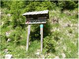 2
2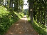 3
3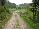 4
4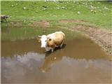 5
5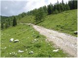 6
6 7
7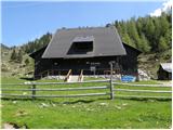 8
8 9
9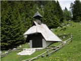 10
10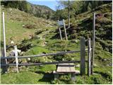 11
11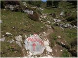 12
12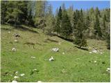 13
13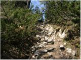 14
14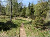 15
15 16
16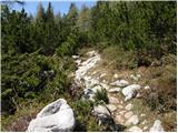 17
17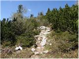 18
18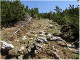 19
19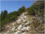 20
20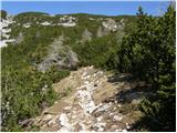 21
21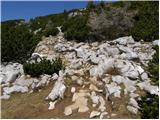 22
22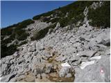 23
23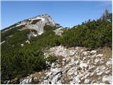 24
24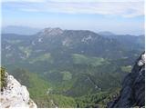 25
25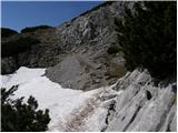 26
26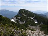 27
27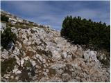 28
28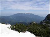 29
29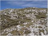 30
30 31
31
Discussion about the trip Planina Loka - Velika Raduha
Show older messages
|
| Gost23. 04. 2007 |
The path is steep but not strenuous. Very nice views. We were there 15 April, some snow left but no problem. Recommended. At the top really nice view to the Carinthian side, took our breath away. On the other side Raduha shows its beautiful rocky slopes.
|
|
|
|
| Gost18. 05. 2007 |
Very easy trail and great views.
|
|
|
|
| Gost26. 07. 2007 |
This is one of the nicer alpine pastures, pleasant path, at the Koča Loka under Raduha excellent hosts, I recommend. Stanko.
|
|
|
|
| majdicst17. 09. 2007 |
We went up in fog - visibility about 10 meters  at 1900 m it cleared up and then the sun accompanied us the whole way at 1900 m it cleared up and then the sun accompanied us the whole way  . The path is somewhat slippery when wet, so care is needed on descent. Otherwise, it is really easy (but steep) and offers exceptional views in good weather. At the hut on Loka, they have excellent schnapps, sour milk and mushroom soup. It's worth then dropping by Snežna jama (respecting the tour schedule!) - fantastic underground. . The path is somewhat slippery when wet, so care is needed on descent. Otherwise, it is really easy (but steep) and offers exceptional views in good weather. At the hut on Loka, they have excellent schnapps, sour milk and mushroom soup. It's worth then dropping by Snežna jama (respecting the tour schedule!) - fantastic underground.
|
|
|
|
| lubi2. 05. 2008 |
Holiday morning, May 2nd, freshly washed after the thunderstorm. Excellent path description, but despite the spring date, winter conditions. Right after Koča na Loki patches of snow and with each step higher more winter conditions. Step by step, slow and careful footsteps and VICTORY. Excellent view, few visitors, but the RIGHT ones. On weekends the caretakers are helped by daughter and son-in-law; good food is joined by good mood and holiday atmosphere. The right people in the right place!!!!!
Recommended - it will be even nicer when the snow cover disappears.
Nadka
|
|
|
|
| simonaplanina18. 07. 2008 |
I was thrilled with the flowers along the path and clear all the way to the top of V. Raduha. It often blows on the summit, but it's still nice!
|
|
|
|
| panda18. 07. 2008 |
Yes, really nice path. Everyone who visits Raduha via this route (via Loka) try to "coordinate" your schedule to also visit Snežna jama. The tour lasts about 1:45 and starts every odd hour (starts at 11:00), last tour at 17:00. Verified, as I was on the mentioned path and in the cave on 29.06.2008. From Loka it's about 35 minutes to Snežna jama. If you have a car below the hut, best to drive about 1.8 km further and park, as there's a large parking lot, and walk to the cave entrance (about under 10 minutes - but steep start). Good luck.
|
|
|
|
| bobo14. 08. 2008 |
From 15 July to 31 August open EVERY DAY
Tours every 2 hours:
- from 9.00 to 17.00
|
|
|
|
| lepenatka11. 03. 2009 |
Hello,
how about avalanches in the Raduha area?
I think it's not problematic, but better safe than sorry...
Safe steps to all and thanks for the information...
|
|
|
|
| geppo11. 03. 2009 |
If you're not in a hurry, on 21.3.09 there is an organized hike to Raduha - if you want to go alone - after that hike the path will be trodden. The difficult one is the path from Grohat ( AVALANCHES )!!
Best regards
|
|
|
|
| lepenatka11. 03. 2009 |
geppo, best thanks for the information and all the best...
|
|
|
|
| geppo11. 03. 2009 |
One more thing - 19 Arničev hike to Raduha - is the name..
Best regards
|
|
|
|
| lepenatka14. 03. 2009 |
I skied it to Raduha today...incredible...no one anywhere, occasionally a touring skier, beauty indescribable. It was sinking a lot, summit was great. Almost no wind, warm, nice view.
Hut almost every weekend open, praise to the keeper.
Wonder why so few visitors. They missed a lot
Next week...hike.
|
|
|
|
| jerry7. 05. 2009 |
Hello,
I'm interested in the latest conditions on the path from Loka to Raduha. Is there still any snow, especially on exposed spots?
Thanks in advance to everyone for replies
Jerry
|
|
|
|
| Stolar7. 05. 2009 |
There is still some snow on the mentioned path. But there are no exposed spots here.
|
|
|
|
| bandy10. 05. 2009 |
Greetings!
From the hut at Loka onwards, snow starts, and there is still quite a bit of it. Need to watch out where snow covers the bushes, the snow is soft and sinks in.
|
|
|
|
| jerry11. 05. 2009 |
Hello, we were also on Raduha this Sunday (10.5.09). About a meter of soft and soggy snow is still on the entire path, so real caution is needed at the spots described by bandy. I would like to add that the last 11 km of the road are gravel and quite torn up in places, which is understandable after this year's abundant snow. In the end, our day was further improved by the very friendly hut keeper.
|
|
|
|
| sonce32. 06. 2009 |
Yesterday (1.6.09) I was on Raduha. We went from Koča na Loki via Durce. The path is, except for small patches of snow and mud, dry and nice to hike. Had super views. On the way back we went via Planina Arta back to the hut. There is quite some fallen timber on the path, otherwise well passable.
I'd like to thank the super friendly caretakers of Koča na Loki, Marija and Joško, who served us well and pampered us overall (we stayed there from Sunday to Monday). Once again, many thanks for everything!
|
|
|
|
| gabi3. 09. 2009 |
I took this path yesterday to Raduha, but I chose the end of the asphalt road as the starting point. After about 10 min. of walking on gravel, a nice forest path branches off to the left, leading to the hut at Loka. It is marked and runs almost entirely in the shade. At first it's a bit steeper, then it becomes more gentle. In some places it's slightly overgrown. From the hut to the top of Raduha the path was nice and normally passable. The hut keepers are really making an effort.
|
|
|
|
| gregor_k4. 09. 2009 |
Gabi: Can you tell me how far the road is asphalted? Thanks!
Best, gregor
|
|
|
|
| gabi4. 09. 2009 |
On the Ljubno - Luče road, turn right at the "Struge" signpost, right after the pub. From there my odometer showed just over 7 km of asphalt. A good part of it seems to have been resurfaced recently.
|
|
|
|
| Zalas2. 11. 2009 |
Hello;
yesterday I was on Raduha past Koča na Loki and in vain looked for the stamp at the hut to mark the hut on the list of Slovenian mountain trail.
Does anyone know where the stamp is located?
|
|
|
|
| geppo2. 11. 2009 |
As far as I know, when my son and I were wandering around there in spring, he got the stamp in the hut! On 15.10.2009 I was again at the summit and called the hut keeper on the mobile - got the answer that the hut is open only Saturday/Sunday anymore.
Regards
|
|
|
|
| nadrovic27. 11. 2009 |
CAN SOMEONE TELL ME WHAT THE SNOW CONDITIONS ARE LIKE ON PL.RADUHA VELIKA. L.P.P.
|
|
|
|
| geppo28. 11. 2009 |
there are no snow conditions, only if snow is falling up there today? which is quite possible!!
|
|
|
|
| geppo28. 11. 2009 |
here is the phone number of the hut keeper at Koča na Loki 041 593 889
the hut is occasionally open on request and the keeper usually knows the conditions. ask and if he knows he will answer you.
lp
|
|
|
|
| miranrebersek4. 07. 2010 |
Today with family on Raduha. Weather was nice, trail is undemanding except in the last part, where a bit more caution is needed when walking on rocks.
I would warn that the stamp at the top of Raduha is completely worn out, in short unusable.
|
|
|
|
| LukaSLO6. 08. 2010 |
Wonderful short tour (walk ). The path is undemanding, except near the top there are some larger rocks. I agree with the previous ones regarding the stamp, because you can hardly see the inscription Raduha in the booklet.
|
|
|
|
| mana6516. 08. 2010 |
Yeah those stamps? Today we didn't even get to the stamp - the box was sewn shut so I'm without a stamp... lesson for others who think they'll make it up without any fitness, they will but time definitely won't be as indicated on the signs?? so take that into account.... nice view, barely my first 2000er, that was my goal, now I'm sticking to 1000ers perfectly fine for me,,, and don't order buckwheat mush I don't know if they don't know how to prepare it they shouldn't serve it... literally just dry flour... hello... but everything clean and nicely arranged regarding that no issue,, and full of foreigners you'll meet they'll remember our mush which is actually really good,,, happy hiking to all wherever....
|
|
|
|
| hiter7. 09. 2010 |
This weekend I'm heading to Raduha. What's it like up there? Best regards
|
|
|
|
| GričarA7. 09. 2010 |
No snow if that's what you're afraid of.
|
|
|
|
| hiter8. 09. 2010 |
Gričar thanks. I'm also interested whether they have already fixed that stamp?
|
|
|
|
| andrejjerina12. 09. 2010 |
The stamp is still usable, but it's mandatory to use a bit of force with your hands and press the booklet against the metal box on the stump. Best regards, Andrej
|
|
|
|
| brish29. 09. 2010 |
On Saturday we're heading to Raduha. I'm interested in the condition of the road from Struge village to the koča na Loki (landslides, fallen trees...)
Best regards
|
|
|
|
| geppo29. 09. 2010 |
Koča na Loki
call the warden Marija 031 244 725
I think no problem with the road
|
|
|
|
| mcredfire12. 01. 2011 |
Nice greetings! For the weekend of 15.1. we plan to visit Raduha, so I'm wondering if anyone knows what the path conditions are like. Weather is supposed to be nice.. Thanks
|
|
|
|
| Borut-Budna8. 02. 2011 |
Nice regards, the conditions on Raduha, weather-wise, are excellent. Regarding other things I would say the following: there is still about 50-75 cm of snow on the summit, and the final ascent from the ridge before Velika Raduha is slightly icy, so caution is not superfluous.
visit 06.02.2011
|
|
|
|
| aonuk125. 02. 2011 |
Tomorrow we're going to Raduha, can someone tell us how far by car? direction koča na Loki.
thanks lp
|
|
|
|
| garmont25. 02. 2011 |
To the Miklavc farm without problems. The road is icy in places but gritted. From Miklavc to Radušnik you have to turn sharply right, where I got stuck this morning due to ice. I recommend continuing to Tevec.
There was one guy up there today who parked at the end of the asphalt on the road to the hut. LP
|
|
|
|
| aonuk125. 02. 2011 |
garmont, many thanks for the description, we'll do exactly as you described.
|
|
|
|
| Majdag12. 09. 2011 |
Short, pleasant path, suitable for everyone. At the top there are views, great. And you can also see Snežna jama cave. Two nice things in one day, wow...
|
|
|
|
| valterp30. 09. 2011 |
Soon (Sunday) we're heading to Raduha with the family. Starting point will be Planina Vodol. Does anyone know if it's possible to go directly from Planina Vodol to Jelovec and then towards Lanež and Raduha?
|
|
|
|
| Kokta6. 10. 2011 |
Nice trail...quite crowded.
|
|
|
|
| msevsek29. 10. 2011 |
Hi, is anyone heading to Raduha tomorrow via Planina Loka - Velika Raduha?
|
|
|
|
| sergejv24. 12. 2011 |
Tomorrow I'm heading to Raduha from Planina Loka. Does anyone have info on snow conditions?
Thanks and best regards
|
|
|
|
| jvali26. 12. 2011 |
sergejv: can you tell me what the conditions are like on Raduha, if you were at the top these days? thanks.
|
|
|
|
| Hallstatt30. 03. 2012 |
Tomorrow I plan to go to Raduha. Equipment: mountaineering boots and poles. Does anyone know if it is feasible or is there still snow?
|
|
|
|
| ŽigaB26. 04. 2012 |
Hi! Does anyone know how the path from Planina Loka to Raduha is? Is there still any snow?
Thanks!
|
|
|
|
| geppo26. 04. 2012 |
It's all white!!
how much there is I don't know, because I looked from another hill.
Regards
|
|
|
|
| Janezs26. 04. 2012 |
As much as I saw today from Komna, it's not bad. In nice weather, half a meter more or less doesn't matter. Regards Janez
|
|
|
|
| hribuc8527. 04. 2012 |
Hello, ŽigaB.
If you hike the mentioned path, please report on the conditions.
Thanks.
Good luck!
|
|
|
|
| ŽigaB29. 04. 2012 |
Hello!
Just back from Raduha, the path is mostly dry except for some snow patches below the summit, but quite muddy in places between the rocks. My 7- and 11-year-old kids also went from the hut to the summit of Velika Raduha, so experienced hikers won't have any trouble! Good luck!
|
|
|
|
| pjoter24. 07. 2013 |
I'm wondering if someone can tell me how the markings are; from the pictures it's not clear if the path is well marked or if you can get lost
thanks
|
|
|
|
| bd24. 07. 2013 |
The path is well marked... you can't go wrong
Regards
|
|
|
|
| lakkon25. 07. 2013 |
just, if you're after the stamp from Raduha, you probably won't get it at the summit. On 22.7 on Monday it wasn't there. But got it at Koča na Loki pod Raduho.
|
|
|
|
| radagremvhribe25. 07. 2013 |
you get the stamp from the friendly hut keeper at koča na Loki pod Raduho, because they steal it at Raduha,
otherwise they have very good mushroom soup and delicious pancakes, tried!!!!
|
|
|
|
| pjoter27. 07. 2013 |
thanks bd
I'll try it tomorrow
|
|
|
|
| smatjaz27. 07. 2013 |
pjoter, don't forget enough fluids, it can get pretty dog-hot up there due to the heat, but if you go down to Grohat there's a tap with drinking water in front of the hut, whereas from Loka to the top there's nothing.
|
|
|
|
| pjoter27. 07. 2013 |
thanks about water, I always have plenty as they say, from excess the head doesn't hurt
|
|
|
|
| cedo31. 07. 2013 |
does anyone know if there's already a stamp at the summit?
regards
|
|
|
|
| lakkon31. 07. 2013 |
cedo,
someone will answer you specifically. But I suggest you do a tour that includes the hut at Loki pod Raduho and just Raduha, and you'll get the stamp.
otherwise, if you have time and need stamps for both huts around, I suggest this loop that I did myself on 22.7:
Robanov kot (Rogovilec) (590m) - Koča na Grohatu (1460m) - Velika Raduha (2062 m) (via climbing route - or the less demanding one via Durce, and even this 'my' one isn't bogeyman) - Koča na Loki pod Raduho (1534 m) – Robanov kot.
look at the map and it will be.
|
|
|
|
| damijanp31. 07. 2013 |
On Sunday there was no stamp at the summit. The caretaker of the hut at Grohat mentioned that it can only be obtained at the hut at Loka.
|
|
|
|
| neph7. 08. 2013 |
The stamp is already in the logbook.
|
|
|
|
| Pohodnica5613. 08. 2013 |
Today on Raduha. The stamp is still in the log box, good to have ink pad with you. The path itself well marked, easy. Descended to Planina Arta and then continued to hut on Loka. Road to hut on Loka in very good condition, especially the gravel part. Extremely friendly caretakers in the hut. Will visit this little paradise hut again.
|
|
|
|
| mpurg4. 09. 2013 |
@lakkon, how much time is needed for this circular path from Robanov kot?
|
|
|
|
| otiv4. 09. 2013 |
This is a full-day tour, 8-10 hours.
|
|
|
|
| simonmanutd5. 02. 2014 |
Is it possible to get up there now? In these conditions?
We plan to go on Sunday.
|
|
|
|
| dejan685. 02. 2014 |
It's possible already, but not wise. Wait 10-14 days and it will be better, Raduha will still be there. regards
|
|
|
|
| pablo27. 02. 2014 |
Probably possible to get up there, even more possible that something very heavy falls on your head.
Currently Prekmurje, Brda, Kras, Istria are available. If there's anything else safe, check here: http://stanje-poti.pzs.si/
|
|
|
|
| punči14. 02. 2014 |
Does anyone know if the road to Planina Loka is passable and what it's like? Has anyone been to Raduha? LP
|
|
|
|
| geppo14. 02. 2014 |
In these conditions it will be harder to drive to Loka....
I suggest to Radušnik. To that farm it's surely plowed and cleared!
From the farm it's then less than an hour to Koča na Loki.
lp
|
|
|
|
| geppo14. 02. 2014 |
In these conditions it will be harder to drive to Loka....
I suggest to Radušnik. To that farm it's surely plowed and cleared!
From the farm it's then less than an hour to Koča na Loki.
lp
|
|
|
|
| Janez Seliškar14. 02. 2014 |
At Koča na Loki there is about a meter of snow (11.02.2014).
|
|
|
|
| punči14. 02. 2014 |
Thanks to both
|
|
|
|
| Zgembo19. 05. 2014 |
I was on Velika Raduha yesterday, the path to the hut is passable, from the hut onwards the snow cover starts, on the top there is about 1.5 m of snow.
|
|
|
|
| tuna.iris9. 08. 2014 |
Conquered, crowd worse than in a shopping mall.
|
|
|
|
| tancib19. 11. 2014 |
Hello, does anyone know how much snow has fallen in the area of Planina Loka?
|
|
|
|
| Janezs19. 11. 2014 |
As always, a few days ago I was also thinking on this path, how little has been done by people on this path, as nature has "placed it", so it has remained until now, I mean only the base. If something is ever done about it, I will stand in the first row with "Pickaxe, Hoe or Iron bar". Some stone broken, others moved and a real path-trail would be created. Similarly Durce, Velika Raduha, not like a path.
|
|
|
|
| dprapr19. 11. 2014 |
"A lot" has been done by people. It's precisely they who have made the path like it is with the crowds. It is indeed unpleasant to maneuver among those stones... I was descending towards Arja last time, and the upper part is similar there too.
But to tackle it with "heavy" tools, I'm not really a supporter. Slowly, carefully, and it will be fine. And as few interventions as possible in our beautiful mountain world.
|
|
|
|
| vespuci19. 11. 2014 |
tancib, if today's picture helps you.....
|
|
|
|
| vespuci19. 11. 2014 |
tancib, sorry for the misinformation, I posted the pictures under current conditions-Menina planina
|
|
|
|
| tancib20. 11. 2014 |
thanks vespuci.. I'm from the coast and wow how much snow there is now I have at least an idea.. thanks a lot
|
|
|
|
| magroman21. 11. 2014 |
Is the hut open for the weekend by chance?
best regards Roman
|
|
|
|
| tancib22. 11. 2014 |
Going to check tomorrow  ... If it's open, I'll casually ask how they're open on weekends... If you're there, see you ... If it's open, I'll casually ask how they're open on weekends... If you're there, see you
|
|
|
|
| otiv4. 05. 2015 |
The mentioned trail runs along the southern side of Raduha and I think there isn't much snow. Perhaps in some shadier spots, where it can be crossed normally without crampons.
|
|
|
|
| radegunda15. 05. 2015 |
Which direction of the circular path would you recommend more?
Planina Loka>Raduha> descent towards Snežna jama; OR
Snežna jama > Raduha > descent towards Planina Loka?
Regards
|
|
|
|
| otiv15. 05. 2015 |
Definitely first to the top of Raduha and then visit Snežna jama, which I think takes about an hour and a bit.
|
|
|
|
| mirank15. 05. 2015 |
Loka -Durce descent to Grohat, from there to Raduha on the more demanding one. Down via Arto and to S. jama is a full day.
|
|
|
|
| navdušena1. 06. 2015 |
Has anyone been to Raduha this weekend - from Loka or from the other side? How much snow, how are the paths? Are the huts open?
|
|
|
|
| seinfeld12. 11. 2015 |
I took this path to the summit today. Dreamy weather, no wind or clouds, at the top, just in the company of ptarmigans, I sat in my shirt. I extended via Durce to Lanež and back towards Loka. 8km hike, in under three hours.
|
|
|
|
| Hribolazec8126. 01. 2016 |
How is it now on this path to Raduha, snow or bare ground?
|
|
|
|
| ŠpRo292. 02. 2016 |
On Saturday on Raduha, up past Snežna jama, down past the hut on Loka. Road to parking below the hut is passable, on the path past Snežna jama there is snow, but due to warm weather it was soft, towards the top and on the top a thin blanket of snow, down towards the hut a bit more frozen snow, lower down mud.
|
|
|
|
| Kidrock26. 02. 2016 |
Does anyone know what the path to Raduha is like? Can you drive to Loka? Thanks
|
|
|
|
| drdivx16. 03. 2016 |
The safest is to Radušnik.
Due to wind the conditions change from hour to hour. In places the trodden path is visible, in places the wind covers it up immediately.
I recommend winter gear, because it's better to carry 2kg more and not use it, than not to have it.
|
|
|
|
| jprim16. 03. 2016 |
@jozeb
This Saturday there should be the traditional hike to Raduha, so I think the hut will be open, call there and get first-hand information.
LP!
|
|
|
|
| vaso197526. 04. 2016 |
Nice greetings. Does anyone know how the current road to Loka is, and of course the path to the summit of Raduha. Thanks.
|
|
|
|
| dejan6828. 04. 2016 |
Snow snow snow. But it will melt after the holidays. Emphasis on after the holidays.
|
|
|
|
| Helena42. 08. 2017 |
The path from the hut to Raduha is a bit steep, but a nice path. The stamp is now attached to a metal chain. At the hut very friendly keepers and very tidy surroundings. The road to Raduha is ok, although it is gravel.
|
|
|
|
| anazala27. 10. 2017 |
How is the road to Loka, does anyone know? Is it passable? Is everything okay? Is the hut open?
|
|
|
|
| mornar28. 10. 2017 |
Was at Loka on 21.10. road in fairly good condition.
|
|
|
|
| kr ena30. 12. 2017 |
Does anyone know how the access road to Planina Loka is and then how the path ahead is? thanks
|
|
|
|
| ejti1. 01. 2018 |
Apparently it's plowed up to where the path to Javor branches off.
|
|
|
|
| majaronka29. 01. 2018 |
Does anyone know what the conditions are like to Raduha? How much snow is there?? Is it frozen?? Past the hut at Planina Loka namely...
|
|
|
|
| J.P.10. 06. 2018 |
We were up there two weeks ago. Green and nice :-) I recommend the blueberry strudel in the hut at Loka. Best
|
|
|
|
| Hribovc8222. 07. 2018 |
Last year's (correction)
|
|
|
|
| kkac29. 10. 2019 |
The local sign is no longer Struge but Strmec.
|
|
|
|
| Valkuk7. 08. 2020 |
Hello, since my son and I are heading to Raduha from this direction soon, I'm interested if it's best to park before the gravel road starts, how much walking there is then to the hut and if the markers to the hut are frequent enough and if you would recommend any other access starting point
|
|
|
|
| geppo7. 08. 2020 |
If it's your first time, just drive to the sign under Loka. From there you have about 15 minutes walk to the hut and then in the heat about 2 hours to the top. The path is quite unpleasant for me in this time of year, in winter I tackle it from this end.
You can also choose to park where the asphalt ends and then walk some more to the hut. Marked and you shouldn't have difficulties. You can also choose from Radušnik. You also have the option to drive to Planina Vodole, park at that well-known junction and via planina Javorje.
Choose the most suitable for you two, there are quite a few options.
LP
|
|
|
|
| Amadeja13. 04. 2022 16:48:52 |
Hello,
has anyone been to Raduha via this path in these recent days? I'm interested if the path is safe given the recent snow conditions.
|
|
|
|
| garmont14. 04. 2022 16:51:41 |
No problems regarding the trail.
But it sinks in…
|
|
|
|
| zagorec15. 04. 2022 11:05:37 |
Hello, I'm wondering, has the snow melted on this trail?
|
|
|
|
| mirank15. 04. 2022 11:43:58 |
What don't you understand - read above?
|
|
|
|
| zagorec21. 04. 2022 06:50:58 |
Sorry if I don't represent everything perfectly, but there are quite a few of us from the neighboring country who also love Slovenia and Slovenian mountains, we just might not get every word right, that's why I asked.
|
|
|
|
| garmont21. 04. 2022 11:22:32 |
There's not much to "represent".
There's quite a bit of snow and it sinks in properly, sometimes up to the knees.
That's how it is in the mountains at this time.
|
|
|
|
| zagorec21. 04. 2022 11:45:27 |
Now it's clearer to me Thank you.
|
|
|
|
| felix23. 04. 2022 14:38:19 |
I also have one question: is the road to P under Koča na Loki already drivable? And don't tell me if I don't get it. If someone doesn't want to share information, they shouldn't vent in another way.
|
|
|
|
| lijaneja23. 04. 2022 18:54:09 |
Feliks, nobody will respond to you when you're so harsh.
I was up there a few weeks ago during the hike to Raduha and there was so little of it that it's surely gone by now.
|
|
|
|
| skalar5026. 04. 2022 00:20:33 |
when one sifts through some of the above statements ...
my god alias world simplicity ...
arrogance and conceit of individuals who obviously (continuously) take the liberty of lecturing others ...
if those who "consider" themselves regular (semi)professional hill walkers don't deem it worth writing even a basic answer then in your omniscience better write nothing ...
if someone asks something friendly - yes even a question where the answer is obvious to regular hikers - they expect an equally friendly reply ... especially if Slovenian isn't their native language ...
immediate "barking" surely isn't the point of this forum ... at least it wasn't years ago
wish everyone safe steps!
|
|
|
|
| dprapr26. 04. 2022 17:08:13 |
I don't see any arrogance or conceit up there. Just one strange question.
|
|
|
|
| Stamp12. 08. 2022 16:38:44 |
Our track to download from Loka "to Raduha and from Raduha" in a loop, if anyone needs it, is here on Wikiloc..
This time, unfortunately, there was a lot of cloud..
|
|
|
|
| Hribovc8216. 08. 2022 10:43:56 |
Yesterday my daughter and I set off for her 1st two-thousander very excited
But I have to say, I haven't experienced such a crowd on Raduha yet  . .
It was a holiday though 
And a short video glimpse
https://youtu.be/wlMlG-xPB7I
|
|
|
|
| LjubimHribe26. 05. 2023 12:33:07 |
Hello,
on Sunday I plan to go to Raduha for the first time. If someone has been recently, has the snow melted on this trail already? What are the conditions?
|
|
|
|
| Hribolazec8127. 05. 2023 17:23:38 |
I love mountains, see you tomorrow up there👌
Apparently it's normally trodden from Loka, crampons in the backpack just in case 😄
|
|
|
|
| LjubimHribe29. 05. 2023 10:24:42 |
Yesterday I was on Raduha and the path is normally trodden (as Hribolazec81 wrote), there's just a little snow left, but crampons are not needed even in the backpack
|
|
|
|
| michael668. 05. 2024 16:37:27 |
How is the road-macadam to this parking lot. Passable for a passenger car?
|
|
|
|
| Klinar279. 05. 2024 00:09:36 |
Not the most beautiful, but you can get there with a lower car too
|
|
|
|
| michael6625. 07. 2024 17:54:33 |
Did the recent storms damage the path to the parking lot below pl. Loka?
|
|
|
|
| jax25. 07. 2024 22:11:29 |
The hut keeper reported on FB that apparently not.
|
|
|
|
| Matjaž592. 11. 2024 09:10:25 |
Yesterday I was on Raduha, the road to the parking lot at Loka is normally drivable. I have a low car (Audi A3), and it went without issues. But you need to adjust speed, both on the asphalt part and on the gravel. On gravel it shakes a bit here and there, that's all. On very rare spots the gravel road is a bit muddy. Weather was ideal, few hikers, no crowds at the top. Super!
|
|
|
|
| xtrinch26. 06. 2025 10:13:34 |
Park below hut at Loka, road there macadam many call desperate but normally drivable. Path from hut to Raduha summit super and safe.
|
|
|
|
| ljubitelj gora16. 07. 2025 20:35:05 |
The road is good, they are also fixing it.
|
|
|
To post a comment you must log in:
If you do not yet have a username, you must first
register.