Planina pod Golico - Kahlkogel/Golica
Starting point: Planina pod Golico (980 m)
| Latitude/Longitude: | 46,47060°N 14,05990°E |
| |
Walking time: 2 h 10 min
Difficulty: easy marked way
Elevation gain: 855 m
Elevation difference along the route: 855 m
Map: Karavanke - osrednji del 1:50.000
Recommended equipment (summer):
Recommended equipment (winter): ice axe, crampons
Views: 456.728
 | 15 people like this post |
Access to starting point:
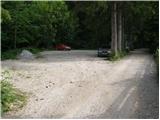
From the Ljubljana - Jesenice highway we take the Lipce exit (Hrušica also possible) and follow the road ahead in the direction of Jesenice, where signs for Planina pod Golico direct us onto an ascending road (the turn-off is marked and is located at the health center in Jesenice). The relatively steep road soon brings us to the mentioned village, where we can in the month of May on the surrounding meadows admire the blooming of narcissi. From Planina pod Golico we drive ahead to the next junction, where we notice numerous mountaineering signposts. Here we continue right and drive a good 50 meters further to the parking lot below Savske jame.
Route description:
At the beginning of the parking lot we notice the mountaineering signs which direct us left along the asphalt road upwards. After a short ascent the path brings us to agritourism Betel and behind it to a junction, where we continue right in the direction of Golica. After a few more minutes walking along the road we arrive at the hut Pri Fencu. Here be attentive, as just a few steps ahead a wide marked path branches off to the right, leading to Golica.
The path ahead climbs over a short meadow behind which we enter pleasant shade along which the path continues. After approximately half an hour of walking we step onto a macadam road, which we follow to the right but only to the lower station of the cargo cableway.
From the cableway we continue towards the mountain hut Koča na Golici along the path which climbs quite steeply through increasingly sparse forest. After a good hour of walking the path brings us out of the forest onto unvegetated slopes from which we already see the hut ahead. A little further we reach a junction where we continue left (right to Struška, Markljev and Pusti Rovt). We follow this path, quite steep in its final section, to the hut.
From the hut we continue the ascent northwards over initially gentle then steep grassy slopes. After a good 20 minutes of ascent the steepness eases and the path turns left. There follows approximately another 15 minutes of walking along the increasingly panoramic summit ridge of Golica.
Starting point - Koča na Golici 1:30, Koča na Golici - Golica 40 minutes.

Photos:
 1
1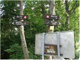 2
2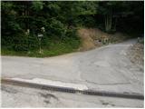 3
3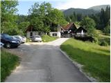 4
4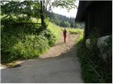 5
5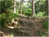 6
6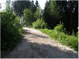 7
7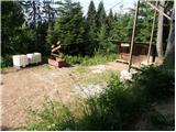 8
8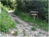 9
9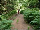 10
10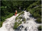 11
11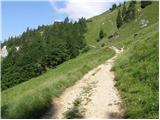 12
12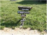 13
13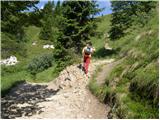 14
14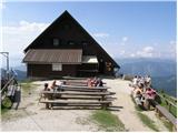 15
15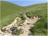 16
16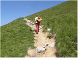 17
17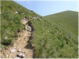 18
18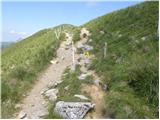 19
19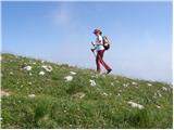 20
20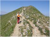 21
21 22
22
Discussion about the trip Planina pod Golico - Kahlkogel/Golica
Show older messages
|
| Gost25. 04. 2007 |
Are the daffodils blooming already and until when?
|
|
|
|
| Gost25. 04. 2007 |
On Sunday, daffodil leaves were visible sprouting (up to about 6-7 cm), flower buds not yet visible.
|
|
|
|
| Gost26. 04. 2007 |
Thanks for the info and best hiking regards.
|
|
|
|
| Gost5. 05. 2007 |
daffodils are on Planina pod Golico, on the top there's still some patch of snow somewhere
|
|
|
|
| Gost5. 05. 2007 |
There aren't actually that many daffodils anywhere. When you look at various photos, you imagine blooming Golica differently. At least I did. But then, when you reach the top of Golica, everything is rewarded with a wonderful view. Even without a sea of daffodils. Best regards.
|
|
|
|
| Gost6. 05. 2007 |
There used to be seas of daffodils - decades ago, although not on Golica, but on the meadows below it (Planina, Javorniški rovt etc.). Probably numerous visitors contributed somewhat to the thinning (just one as a souvenir ...), but even more so probably the different way of farming. And also this: questions appear everywhere whether there are already daffodils on Golica, but I've noticed several times that these people have never been to Golica and don't intend to go, and in their question they seem to mean the meadows BELOW Golica.
|
|
|
|
| Gost6. 05. 2007 |
Golica is beautiful even without daffodils!
|
|
|
|
| Gost10. 05. 2007 |
 HELLO, I'M WONDERING IF THE TRAIL IS VERY STEEP OR IF A HEART PATIENT CAN HANDLE IT. HELLO, I'M WONDERING IF THE TRAIL IS VERY STEEP OR IF A HEART PATIENT CAN HANDLE IT.
THANKS FOR THE KIND REPLY!
|
|
|
|
| Gost10. 05. 2007 |
I think you should ask the doctor treating this heart patient (it applies to any exertion, especially multi-hour hikes in the mountains, and heart issues can vary greatly). Otherwise - slowly gets you there. I get really out of breath going uphill, so I take quite a bit longer for every trail than stated in the description, but I've always reached everywhere I intended (everyone overtakes me, so what!).
|
|
|
|
| Gost13. 05. 2007 |
We should go to the mountains and hikes according to our abilities and common sense, as you know they say: the mountain is not crazy but the one who goes up. To Golica the path is not entirely a walk. If you want to see daffodils and enjoy the view of the sea as well, I recommend Slavnik. To Slavnik there are more paths and also a road, which is gravel but drivable.
|
|
|
|
| Gost19. 05. 2007 |
Tomorrow we're going to Golica. Is there a possibility to miss the trail?
|
|
|
|
| Gost20. 05. 2007 |
Is there a possibility for a family picnic!?
|
|
|
|
| Gost22. 09. 2007 |
If the path to Golica is -easy marked path, I don't dare imagine what demanding paths are by your criteria.
|
|
|
|
| Gost22. 09. 2007 |
Maybe we should go more often on some medium difficult hikes and then realize that Golica is a piece of cake, otherwise it depends on one's abilities, many can't even manage Rožnik
|
|
|
|
| Gost24. 09. 2007 |
Regarding individual capabilities, I'm curious where YOU went on your trip!
|
|
|
|
| Gost25. 09. 2007 |
We went to Snežnik, which is 1796m high, and is the highest peak of the Primorsko Notranjsko hribovje. Leave the car at the hut on Svišaki. If well prepared, just under two hours, if less fit, up to three hours. Don't forget appropriate clothing, as it always blows on the top, and the sun usually burns in the wall.
Beautiful view and sight to Triglav, Benečije, Adriatic Sea and islands.
lp
|
|
|
|
| johnybravoslo18. 11. 2007 |
Hello mountain friends,
today 18.11.2007 we were with friends in snowy conditions at the top of Golica. Snow 20 to 30 cm at the top, blowing from Austria and cold as h.... .
The hut was closed anyway. I don't know what drove us, just pure ... they go up in such cold. But it was nice.
LP
|
|
|
|
| Gost19. 11. 2007 |
Important that it was nice.
|
|
|
|
| johnybravoslo25. 11. 2007 |
yeah, and you'll still have to go up in snowy conditions.
LP
|
|
|
|
| Gost26. 11. 2007 |
For me, Golica is most beautiful in winter, when there is no crowd and I can enjoy the view of the Julian Alps. Vasja
|
|
|
|
| Gost29. 11. 2007 |
I would go this year while there is still no snow.
I'm a bit slower, what do you recommend?
|
|
|
|
| johnybravoslo2. 12. 2007 |
We recommend.... go up as soon as possible so snow doesn't catch you.
LP
|
|
|
|
| Gost2. 01. 2008 |
On the last Saturday of 2007 there was a fantastic ascent to the top of Golica. Nice sunny day, no clouds, lounging in front of the closed hut, unforgettable panorama, plenty of snow too. It was worth it!!! Lp
|
|
|
|
| pita28. 04. 2008 |
I'm wondering if anyone knows if the daffodils are already blooming this year,
thanks
|
|
|
|
| sebanakis28. 04. 2008 |
I'm wondering if the hut on Golica will be open on May 1st?
Thanks for the info
|
|
|
|
| Biser gora28. 04. 2008 |
I think the daffodils aren't there yet as they usually bloom mid-May. Wait another two or three weeks.
|
|
|
|
| majdicst30. 04. 2008 |
No trace of narcissi - except in the gardens at Planina pod Golico. On Saturday the hut was open only provisionally, tea and some drinks were available. There is still quite a lot of snow on the summit and caution on the ridge is advisable.
|
|
|
|
| lubnikar7. 05. 2008 |
Today at Planina pod Golico and on Golica. Very few narcissi. The first ones are along the path right above the guesthouse, towards the hut on Golica there are none yet.
lubnikar
|
|
|
|
| nirovaDK30. 04. 2009 |
Are there already daffodils on Golica?
|
|
|
|
| ruzo8. 05. 2009 |
On 7.5.2009, the hut keeper at the hut on Golica told me that they are not yet up there, but on Planina pod Golico they are already in bloom.
She said they expect them around the hut from 10 to 20 May.
|
|
|
|
| MaticMrva11. 04. 2010 |
Is the snow melting already? When can we expect daffodils? LP
|
|
|
|
| kris26. 04. 2010 |
Is the hut on Golica still closed?
|
|
|
|
| savinčan29. 04. 2010 |
I'm curious if the daffodils are already there or if it's too early
|
|
|
|
| heinz30. 04. 2010 |
For Golica a few weeks too early, in Pl. pod G. and Plavški rovtu it's only slowly starting..
|
|
|
|
| Micky1. 05. 2010 |
I think around May 20th will be a suitable date for enjoying daffodils. Am I wrong?
|
|
|
|
| heinz1. 05. 2010 |
Well, somewhat. Because in Plavški Rovt, for example, the daffodils are already quite "ripe" at the moment.
|
|
|
|
| savinčan4. 05. 2010 |
Thanks for the info, then this weekend is just right to check it out but where is this Plavški rovt anyway? Where on the path?
|
|
|
|
| heinz4. 05. 2010 |
If you're going - driving from Jesenice towards Planina pod Golico, after about 1km uphill you'll come to a junction with a guesthouse on the left. Turn left there (sign Plavški rovt, Žerjavec). After another 1-1.5 km when you reach the village, it will be clear. Narcissus fields on the left, signs about picking etc.
Of course, this weekend will be fine. If the narcissus there are already a bit "tired" - old, e.g. because of the rain, just continue a bit further along the road in the same direction. Higher up they are younger. They grow everywhere, so if you take one for memory it won't hurt.
Farmers only care about the grass (so that visitors to narcissus fields don't trample too much of it)..
Have a nice trip!
|
|
|
|
| jesen5. 05. 2010 |
..Farmers only care about the grass (so that visitors to the narcissus fields don't trample it too much)..??
...Today there is less picking of narcissus, locals note, also thanks to signs warning that narcissus are protected and must not be picked. "We always ask visitors not to pick narcissus, because they are most beautiful where they bloom,"... from an article published in GG, Wednesday, May 9, 2007 |
Guest
6.5.2007
..Probably numerous visitors contributed somewhat to the reduction (just one for a souvenir ...)
Regulation on the protection of wild plant species URL RS 46/04...
I also wish everyone a pleasant trip!
|
|
|
|
| heinz5. 05. 2010 |
My comment should explain to you:
Excerpt from an article by Ladot Brišar titled Sometimes it's hard for me, published in June 98 in Planinski Vestnik and read on Radio Slovenia on 19.11.99:
"North of the summit towers Lenčkov špik, which is over a hundred meters higher, a friendly forested peak. To the west are the lower peaks Sušje and Merca. Legend has it that there is a lake in Merca, when Merca opens, Jesenice will be underwater. Between these hills there are sinkholes, some still alive, many overgrown. In May they turn white, as ramsons flowers bloom. A few years ago I took a group of expatriate teachers from Doberdob up there. First I explained to them that what they see is not snow, not narcissus, that it is nicely called ramsons in Slovenian, and they are protected. Picking strictly forbidden. Then a local arrived from behind the edge with a mower, ... An older lady asked: 'Can we pick them now that they are mowed?'. The farmer said to pick as many as possible, since livestock doesn't like narcissus. How I got out of that mess I don't know, probably I started talking about magnificent views and the like."
Best regards, heinz!
|
|
|
|
| vitica8. 05. 2010 |
So the daffodils or "ramsons" are already blooming. Didn't the long winter delay them? Next Saturday (15.5.2010) we're heading to Golica, and we wouldn't want it not to be in bloom.
Thanks!
regards
|
|
|
|
| heinz8. 05. 2010 |
Aha, they are blooming. Currently a bit lower, as every year. They usually don't delay or hurry..
Golica itself (mountain 1500-1800 m a.s.l.) on 15.5. won't be fully "in bloom" yet. There might be some near the hut.
You'll certainly enjoy them anyway.
|
|
|
|
| katjuša29. 05. 2010 |
Apart from that, we got a bit "wet", we had a nice trip to Golica today.
In places the path is quite wet and muddy, and the weather with rain does its part.
The narcissi are blooming and smell very nice in the lower part.
Since there weren't many hikers, we could enjoy their beauty in full splendor.
|
|
|
|
| mojcej'7217. 05. 2010 |
Today, on 17.5., we three girls decided to take a free day and headed to Golica. Up to the Koča everything was great, about 100m further it was blowing coldly, over the saddle the wind only strengthened and didn't stop along the ridge to the summit either. At the probable fact that a gust of wind could blow us to Austria, on the way back we were looking forward to the tea in the hut, where we returned to normal body temperature. When we left the hut, the sun came out and with a smile on our faces we danced down to the valley, where fields of white narcissus awaited us! Great day.
|
|
|
|
| Bojan C.26. 05. 2010 |
Beautiful day, though a bit windy. Wonderful carpets of daffodils simply enchant you.
But it certainly wasn't a lucky day for the one who lost CAR KEYS for OPEL vehicle. I found them on the daffodil meadow about half an hour walk from the parking lot towards Golica. The owner is waiting for the keys at PR`ČOP inn in Planina pod Golico.
|
|
|
|
| aonuk127. 05. 2010 |
I was also there yesterday with my family on Golica. I have to say that the daffodils below the summit are just starting to open their flowers.
|
|
|
|
| Parkeljc29. 05. 2010 |
Today there were people on Golica like in a long time. True, there was a race to Golica in the afternoon hours, but in the morning I really didn't expect such a rush. Start was from Betel past the hut to Golica, due to the large number of hikers I extended the return route by a good hour, namely along the ridge to Krvavka and descent to Sedlo Suha saddle, then ascent to Ptičji vrh and again descent to Sedlo Kočna saddle, before Pusti Rovt descent past Markljev Rovt and along the road to the starting point. All in all good three hours of walking. Sedlo Suha was completely parked up!!!
Narcissi are only left in the upper part of Krvavka and on the meadow and under the ridge towards Ptičji vrh, like a white carpet, and they smell nice too.
|
|
|
|
| oakley_sf4. 11. 2010 |
No, there's no snow on Golica. I was under Golica today and there are no traces of snow, maybe somewhere in the forest in the shade.
|
|
|
|
| oakley_sf12. 11. 2010 |
Well, for tomorrow I decided to march to Golica. To enjoy a bit of snow 
|
|
|
|
| KristinaG14. 11. 2010 |
Then maybe we met somewhere... The weather was great, if it had blown less from the hut towards the summit, it would have been catastrophically ideal.
|
|
|
|
| oakley_sf14. 11. 2010 |
Possible, I was at the hut at 9, started from Jesenice on foot. Yeah, the weather was fine, otherwise I'm a bit sorry I didn't go today, because today it was even nicer. The forecast fooled me a bit...
|
|
|
|
| KristinaG14. 11. 2010 |
The forecast fooled me a bit too. I intended to go somewhere higher today, but I succumbed to the bad forecasts and settled for just Polhograjska Grmada. 
I was a bit later at the hut. But on the way up I met three hikers who were heading down.
|
|
|
|
| oakley_sf14. 11. 2010 |
Hehe, same here, I wanted to go to Stol, but I wanted nice weather to accompany me... but the forecast was completely off 
|
|
|
|
| main6. 03. 2011 |
The hiking trail from Planina pod Golico - Golica 359 (direct) on the section from Fenz across Betelov travnik has been relocated to the old cart track. It is 10 m from the previous trail and runs parallel for 200 m. The current trail is fenced by the shepherd. The meadow trail will overgrow with grass, so we politely REQUEST visitors to use the newly renovated trail that PD Jesenice markers prepared with great effort. Thank you for understanding.
Source: PZS website
|
|
|
|
| markog6. 04. 2011 |
How are the narcissus this year? When would be the best time to see this beauty?
|
|
|
|
| katjuša28. 04. 2011 |
Around May 10th, at the foot it's already all in bloom, the higher you go - the less flowers there are.
|
|
|
|
| P&A9. 05. 2011 |
First-hand from yesterday ... The meadows are full of daffodils. Wonderful.
|
|
|
|
| jaksa10. 05. 2011 |
When looking from Suha saddle towards Golica, everything is white with narcissus. It cannot be described, it must be seen. It's magnificent, and the weather last weekend was perfect. Once again Slovenia showed its beauty.
Greetings to all and happy hiking.
|
|
|
|
| minka5. 07. 2011 |
I'm interested in the trail from Planina pod Golico to Rožca, back via Klek and Jekljevo sedlo to the top of Golica. Is it marked? How many hours of walking?
|
|
|
|
| ben5. 07. 2011 |
The trail is marked, walking time depends on the individual. About 3 hours of moderate walking should suffice.
Best, B
|
|
|
|
| tisa6. 07. 2011 |
Minka, I suggest a circular trail from Planina pod Golico to Rožca via Klek and Jekljevo sedlo to Golica and past the hut under Golica to the start - Planina pod Golico. You'll spend 4-5 hours with breaks. The trail is definitely most beautiful during narcissus bloom, which I've experienced myself. Good luck
|
|
|
|
| minka6. 07. 2011 |
Tisa! Thanks for the information.
Nice hiking greetings
|
|
|
|
| Kokta31. 10. 2011 |
Nice weather, few people... fantastic. Definitely visiting again in spring.
|
|
|
|
| čemšeničan1. 11. 2011 |
Even on Sunday there was little traffic; at seven in the morning we were alone with my colleague on the summit; that's why so many more chamois on the Austrian side.
|
|
|
|
| GregorC1. 11. 2011 |
Seems like there are no crowds on Golica except when the narcissi bloom. This year I visited it 2x (June and September) and both times together I didn't meet 10 people . But that's why I enjoyed the peace even more. . But that's why I enjoyed the peace even more.
|
|
|
|
| janez.novak10. 01. 2012 |
Today I was on Golica from Fenc. Up to about 1300m there is little snow on the trail and you have to be careful because of slipping. Further on real winter, no avalanche danger, only possible strong wind on the ridge. real winter tour
|
|
|
|
| stefy10. 04. 2012 |
Hello! In May I plan to go to Golica. Can anyone tell when the daffodils will bloom? Thanks
|
|
|
|
| katty10. 04. 2012 |
I went up last year on 8.5 and everything was already blooming. Already at the starting point there were tons of daffodils, along the path a bit more. But in my opinion best to go midweek-if you have time, because otherwise at the weekend you encounter an incredible crowd of people.
|
|
|
|
| jvali10. 04. 2012 |
great, the last two comments answered my question too and I've already made a plan for a family visit to this mountain. thanks stefy and katty. valerija
|
|
|
|
| danicak12. 04. 2012 |
last year I was on Golica one week before daffodil festival. There was a big crowd but still very nice, daffodils were blooming too, I think it was around May 15. Most daffodils though are at the start of the path.
The path really for occasional hikers who are enduring-) Hope I gave some useful information.
|
|
|
|
| anja sanja12. 04. 2012 |
Stefly, I think you can go to Golica already earlier with this pace of water and temperatures they will bloom soon, currently they are already quite big re greenery I think. Around 1.5. I think quite early if no frost if I go up again I'll inform you of the state ;-)
but I suggest to you if you'll be in our parts to head also to Plavški rovt it's more easily accessible also on foot and to me personally much nicer. Car you leave at the chapel and then 3 steps aside you have daffodils we call them ključavnice :-) hope I helped you with decision :-)
|
|
|
|
| stefy13. 04. 2012 |
Thank you for all this information!!!
|
|
|
|
| turbo13. 04. 2012 |
@stefy
...don't wait for spring, don't wait for May
|
|
|
|
| pungartnik.darja21. 04. 2012 |
I'm one of the curious ones too, wondering when the daffodils will be in full bloom... :-)
So, welcome announcers with words and pictures ;-)
Thanks.
|
|
|
|
| heinz22. 04. 2012 |
On the hollows (Javorniški, Pl. pod G.) they are starting to bloom, higher up towards Golica it will still be some time. Currently snowy.. We'll say something about it when it warms up.
|
|
|
|
| sofer25. 04. 2012 |
Are there maybe any narcissi on Golica yet?
|
|
|
|
| sla25. 04. 2012 |
They are on Šmarnogorska Grmada :-)
|
|
|
|
| otavnik28. 04. 2012 |
Golica is always beautiful. I was there on 1.1. and today 28.4.2012. I saw blooming daffodils only behind Fenc, higher up no. Today it was wonderful. I chose the route past Fenc, along the winter path to the hut, to the top, then along the ridge - along the border across Markova planina back to the car under Betel.
|
|
|
|
| katty29. 04. 2012 |
How is the trail... snow, mud? If I go up these days, I planned from Javorniški rovt.
|
|
|
|
| otiv29. 04. 2012 |
At 1600 m above sea level, crocuses are currently blooming, daffodils are 10 cm high and need another 14 days or a bit more to bloom, it all depends on the weather.
Best regards to all!
|
|
|
|
| Janiel7410. 05. 2012 |
Is it already blooming on Golica?
|
|
|
|
| Parkeljc12. 05. 2012 |
Above Pristava in Javorniški rovt and a bit higher on the clearings along the road towards Križovec it's already all white, also the meadows in Plavški rovt and Planina pod Golica likewise, higher up on the slopes below Krvavka and Mala Golica they are not yet in full swing.
|
|
|
|
| Janiel7412. 05. 2012 |
I checked everything today. Wonderful morning in clear sunshine... later dark clouds came quickly... I assume not everyone made it down dry
|
|
|
|
| sofer14. 05. 2012 |
When I look at the weather map, today is high cloud cover, I hope tomorrow will be sunny and nice when I go to Golica. Nice hike to everyone.
|
|
|
|
| franjo6618. 05. 2012 |
Already blooming on Golica?
|
|
|
|
| mami18. 05. 2012 |
We were on Golica on 5.5. We went through Javorniški rovt and the narcissuses were already blooming. It was nice, just cold. I recommend gloves, hat and warm windbreaker.
|
|
|
|
| čeveljc19. 05. 2012 |
Today we went from Plavški rovt through Planina pod Golico and then below Španov vrh to Pristava. On sunny slopes the narcissuses have already wilted, below Španov vrh everything is still blooming and fragrant.
|
|
|
|
| margu5020. 05. 2012 |
Some snapshots from wandering among the meadows full of daffodils.
|
|
|
|
| IgorZlodej20. 05. 2012 |
I'll have to move it to forum conditions, because here it's not possible to upload pictures
|
|
|
|
| margu5020. 05. 2012 |
I noticed it, thanks anyway for the warning !!
I'll try if it works there.
|
|
|
|
| Sascha7. 06. 2012 |
Golica is gorgeous, but the stampede of uncultured people ruins everything. Never again to Golica in the May weekend.
|
|
|
|
| zanesenjak22. 08. 2012 |
This trail is very nice, but quite steep, not exactly for the first ascent at the beginning of the season. Time 2 hours and 10 minutes is enough for fairly moderate walking with several breaks. I think for faster ones 1 hour and 50 minutes is enough too.
|
|
|
|
| Petra8811. 05. 2013 |
Does anyone perhaps know if Golica is already adorned with daffodils?
|
|
|
|
| Ronaldinho8211. 05. 2013 |
I was there last weekend (Saturday 04.05.2013), but no daffodils yet. Except two specimens. End of May it will probably be all white
|
|
|
|
| alenka.samec16. 05. 2013 |
Does anyone know how the narcissi under Golica are now?
|
|
|
|
| idrtop24. 05. 2013 |
This is how it looked on May 21... down at Planina pod Golico:
|
|
|
|
| Petra8826. 05. 2013 |
Does anyone know, is there currently snow on Golica, or can one go to see the narcissus? THANKS
|
|
|
|
| otiv27. 05. 2013 |
@Petra88 Click on current conditions, find mountain Golica, where you get all accurate information, including about the narcissus.
Best regards!
|
|
|
|
| Rokovnjacica28. 05. 2013 |
but are they really ključavnice narcissi and not narcissi who knows? who knows?
|
|
|
|
| otiv28. 05. 2013 |
Both are correct. We also find other names that are of local character.
|
|
|
|
| Rokovnjacica29. 05. 2013 |
ok..thanks, I read it all and had a really good laugh
|
|
|
|
| jelka516. 06. 2013 |
Just arrived from Golica. Narcissi are still on the meadow below the mountain hut. Not many people, so no problem with parking. In Koča pod Golico we drank coffee - regular without sugar and milk - for 2 EUR - very salty price, don't recommend, because it's not as good as it's expensive. The strudel for 2.5 EUR is also very small.
|
|
|
|
| marinka6722. 09. 2013 |
On Saturday the chanterelles along the path through the forest were jumping into the backpack by themselves!
|
|
|
|
| miranr5. 04. 2014 |
When will the daffodils be visible this year - does anyone know? I promised my wife and daughter...
|
|
|
|
| otiv5. 04. 2014 |
For May Day holidays they will probably already be there, just not the top of Golica. It all depends on the weather, as every year.
|
|
|
|
| hitri polž10. 04. 2014 |
This year's winter was milder, so I hope the narcissi will already be blooming for the May Day holidays. It would be a super trip and excellently utilized holidays.
|
|
|
|
| Hurtas15. 04. 2014 |
Today I was up there. The hut is still nicely trapped in snow, on the top real winter. No flowers
|
|
|
|
| zene27. 04. 2014 |
Are there already some flowers blooming on Golica, is it worth checking on Wednesday or Thursday? Does anyone know anything?
|
|
|
|
| zabava4. 05. 2014 |
On Saturday I'd like to go to Golica. I'm interested in what the path is like, I hope there's no more snow.
|
|
|
|
| Ben-ko7. 05. 2014 |
Are there already daffodils on Golica?
|
|
|
|
| otiv7. 05. 2014 |
Daffodils are currently blooming on the lower rovti.
|
|
|
|
| Majdag7. 05. 2014 |
.. fun, Ben-ko - on the forum/conditions I wrote today's status of daffodils and the path. Photos are also included, regards
|
|
|
|
| vanya10. 05. 2014 |
I'm wondering if anyone has been up on Golica this week, we plan to go next weekend, and I'd like to know if the narcissuses are already in full bloom all over the mountain?
|
|
|
|
| Lunca10. 05. 2014 |
I was there yesterday... it's not quite there yet
|
|
|
|
| vanya11. 05. 2014 |
thanks for the reply-when would be the best time to go then, in 14 days??Or will it be too late then?I really want to see that meadow when it's in full bloom, that's why I'm asking, because I don't want to go too early, not too late..
|
|
|
|
| Majdag15. 05. 2014 |
... Even last year around May 20 snow whitened Golica, but on May 28 everything was white with narcissuses. It will be the same this year. Photos on Forum/conditions were still delighting in early June 2013 with beautiful flowers of white narcissuses. Nature always provides so that it's right..
|
|
|
|
| Kabemmm19. 05. 2014 |
Since I don't have a car, I'm thinking of going by train/bus from Ljubljana to Jesenice and then on foot towards Golica. How much walking is there from Jesenice? Thanks
|
|
|
|
| francimedved19. 05. 2014 |
From Jesenice to Planina it's about 4 km, otherwise a local bus also runs from the station in Jesenice.
|
|
|
|
| Kabemmm19. 05. 2014 |
Oh super, thank you! I'll ask passers-by a bit where the stops are etc...
|
|
|
|
| dzuko28. 09. 2014 |
Today, on 28.09.2014, on the path from Planina pod Golico to the summit and down to sedlo Suha and back to Planina pod Golico, I lost black car keys without a keychain - Alfa Romeo. If anyone finds them, please notify me. Thank you!
051 228 714
luka.modic@gmail.com
|
|
|
|
| alen154. 03. 2015 |
What are the conditions like on Golica this week? Can you get up there with small crampons?
|
|
|
|
| feliks 595. 05. 2015 |
Hi, are there already daffodils on Golica? Thanks for the reply.
|
|
|
|
| otiv6. 05. 2015 |
@feliks59, check left under forum conditions and I think everything will be clear.
|
|
|
|
| zabava11. 05. 2015 |
Yesterday we girls were on Golica. It's all white with narcissus. On top of Golica, a colorful snake was sunbathing. It was a beautiful day and a beautiful trip.
|
|
|
|
| aditaker9. 08. 2015 |
I would ask, since I'm going to Golica tomorrow, if the marked path is already fully from below from the center of Jesenice to the top or do you need to drive higher to Planina pod Golico? And if it's marked by chance from Jesenice center, how long does it take to walk from there to the top?
|
|
|
|
| lotr19. 08. 2015 |
I'd say the path from the valley extends the walking time by at least two hours. If you don't want to walk on asphalt to Planina pod Golico, I recommend starting from Koroška Bela via Pristava to the summit or something similar. There are also some unmarked variants, for example this one and similarly onwards via Križovec or descent to Planina pod Golico and then the standard path to the summit.
|
|
|
|
| Dayna3. 05. 2016 |
Are there any daffodils on Golica yet?
|
|
|
|
| Majdag3. 05. 2016 |
It's white up there, but from snow. You'll need to wait a bit longer, they are in Plavški Rovt though.
|
|
|
|
| Zdenkob9. 05. 2016 |
As I see, there was still snow on Golica about a week ago. What do you think, those who know Golica better, when should the daffodils be this year, so I can plan a trip up there and not miss them?
|
|
|
|
| skala1239. 05. 2016 |
Today on Golica. Below Mala Golica, where daffodils grow, they are not yet there (probably another 10 days), but lower down they are already.
|
|
|
|
| Zdenkob9. 05. 2016 |
How much snow is still on the path to the summit?
|
|
|
|
| Zdenkob18. 05. 2016 |
Thanks for the attached link. The upcoming weekend is supposed to be rain-free, so maybe it's worth heading up the mountain.
|
|
|
|
| ribicm18. 05. 2016 |
Hello, are the narcissus already in full bloom or should I wait another day?
|
|
|
|
| ločanka19. 05. 2016 |
Narcissus are in full bloom down below, on Planina pod Golico and just a little higher. In the area of Mala Golica, Krvavka and Golica there are practically none yet.
|
|
|
|
| odklop22. 05. 2016 |
narcissi are practically gone, but instead hordes of hikers from all over Slovenia, whoever goes to the mountains to enjoy nature, peace and quiet I STRONGLY advise against Golica
|
|
|
|
| Hribolazec8131. 05. 2016 |
What is the road like along this described gravel road, can you reach it with a slightly lower car, is the hut below Golica open tomorrow?
|
|
|
|
| ssss6. 07. 2016 |
I have one question. How long does the trail take if you go on foot from Javorniški Rovt to Planina pod Golico?
|
|
|
|
| kahu19. 04. 2017 |
Hello! Does anyone know if there are already daffodils on the trail to Golica? Thanks!
|
|
|
|
| Majdag19. 04. 2017 |
..At Pristava they are already there, it says on FB, on Golica there is snow.
|
|
|
|
| aditaker7. 10. 2017 |
Can someone tell me what the current conditions on Golica are, is there already snow on the top or is it still dry?
|
|
|
|
| aditaker5. 01. 2018 |
Hello! Tomorrow I plan to go to Golica and I'm interested, since it will be my first time up there in winter, what the conditions are like now, especially whether it's possible with low running shoes up there because I would slowly run to the top, so I'm interested in how thick the snow cover is and if the path is safe? And also where is best to leave the car, because I wouldn't want to drive high up in these conditions, I was thinking to leave it as described under Savske jame or at the end of Planina pod Golico where there is parking, and I'm interested if the road there is normal and good now?
|
|
|
|
| ljubitelj gora5. 01. 2018 |
Avalanche-prone and dangerous, you must go by the winter route, the described path above is not safe. Leave the car as in the first picture.
|
|
|
|
| ljubitelj gora5. 01. 2018 |
Avalanche-prone and dangerous, you must go via the winter route, the described path above is not safe. Leave the car as in the first picture.
|
|
|
|
| misace21. 04. 2018 |
Yesterday 20.4. on the Winter path to the hut almost no snow is needed (last couloir below the hut), on the Summer path avalanches will still persist. White also on the ridge, in between from white crocuses Wherever there is snow in between there are also hollow "flehe" that break through unpleasantly or muddy slide. Still solitary and little visited
|
|
|
|
| Salewa18. 05. 2018 |
Can you reach Sedlo Suha by car?
|
|
|
|
| aditaker13. 07. 2018 |
Hello! Can someone please tell me approximately how long it would take if starting for Golica already from the health home in Jesenice?
best regards ROk
|
|
|
|
| heinz13. 07. 2018 |
Less. Approx 3.5 - 4. According to the data from the PZS link even like this: Local asphalt road Jesenice-Planina pod Golico 4 km, to the hut - 2 h 30. (+30 min to the top, so total 3 hours), which seems too little to me for average hiking.
|
|
|
|
| SauberM23. 04. 2019 |
Hello.
I'm just wondering if the daffodils are already blooming or not yet?
Thanks!
|
|
|
|
| keti123. 04. 2019 |
Some are already there on Plavški Rovt.
|
|
|
|
| Army_n23. 04. 2019 |
Hi
On Golica there are none yet, still a week or two
And the hut opens on May 1st, Miss Narcis is on 12.5.
|
|
|
|
| SauberM25. 04. 2019 |
Great.
Thanks for the info.
|
|
|
|
| TravelVes22. 05. 2019 |
Does anyone have information on the conditions on Golica? A while ago I noticed warnings of avalanche risk due to snow. Is the ascent to Golica already safe? Thanks
|
|
|
|
| zdravkoz3. 06. 2019 |
How are the narcissi this year, given the rainy May?
|
|
|
|
| Majdag3. 06. 2019 |
zdravkoz- narcissi are blooming.
|
|
|
|
| golica11. 06. 2019 |
asking the experts..... will the narcissus bloom still be in full swing on Saturday?...we have a group hike planned. Or will they already be wilting?
thanks for the info
|
|
|
|
| sscott8. 05. 2020 |
how is it this year with narcissi on Golica?
|
|
|
|
| Majdag8. 05. 2020 |
sscott, next weekend, maybe...
|
|
|
|
| Jusk8. 05. 2020 |
They are already there, yesterday I was up there.. in a few days there will be even more, for now there are still more buds than flowers. Lp
|
|
|
|
| flowers and feelings24. 05. 2020 |
I'm wondering about parking from the Jesenice direction. Any recommendations, rules?
|
|
|
|
| Majdag24. 05. 2020 |
Parking.... during the week no problem. Yesterday everything was jammed with cars. On roads from Križovec in all directions, around Markeljnova planina, Korlnov rov and the whole village Planina pod Golico. And even on the road almost to the turnoff for Plavški Rovt, insane. I just drove through... Also on the road "Za Mavri," all full..
|
|
|
|
| Jusk27. 06. 2020 |
This afternoon on Golica.. path ok, at the top no one except a few 100 sheep weather hot but windy.. far up in Austria thunderstorm clouds were visible. Return path along the ridge to Suha, Križovec and towards Planina pod Golico. Lp
|
|
|
|
| Boštjang6. 05. 2021 18:33:56 |
I'm interested if the narcissi are already blooming on Golica? Thanks
|
|
|
|
| Majdag6. 05. 2021 19:04:28 |
Some are already blooming in Plavški Rovt, below Mala Golica there are none yet.
|
|
|
|
| Jusk6. 05. 2021 20:27:53 |
Given that there's still some snow on Golica and temperatures aren't very high, I'd say in about 3-4 weeks.. in the villages below, the first ones bloomed about 10 days ago.. Lp
|
|
|
|
| felix9. 05. 2021 13:16:57 |
Does anyone know about the drivability to the starting points under Golica, I saw somewhere that the roads will be closed on weekends, and buses will run to Planina pod Golico and to Javorniški Rovt?
|
|
|
|
| Jusk9. 05. 2021 14:01:41 |
Check the thread "takle mamo na Jesenicah", the bus schedule is also posted. Lp
|
|
|
|
| Majdag19. 06. 2021 21:17:02 |
Golica, Suha saddle, Markeljnova planina, Savske jame.. I start from the parking lot below and past Fenc, then along the road and at the bend upwards towards the loading station. The beautiful narcissus meadows have said goodbye for this year. They still give the impression of white meadows. They are still beautiful only around the hut and on the sunny ends of the slopes. For those whose health doesn't allow, enjoy and wander with me in the pictures on the link below. Good luck!
https://jelenkamenmajdag.blogspot.com/2021/06/jaz-pa-pojdem-na-golico.html
|
|
|
|
| Jusk18. 06. 2022 21:48:22 |
Nice trip at that picture where you're wondering where the family with the dog is descending, there is one of the paths from Austria, by description it looks like a nice pathhttps://www.hribi.net/izlet/podrozca___rosenbach_golica_cez_planino_kladje/11/252/6459 another undescribed path from Austria goes to the saddle Suha, you probably noticed the path there at the border stone, last time I was there I explored it a bit, for a while it's a flat path, when it starts descending towards Austria I turned back
|
|
|
|
| Majdag19. 06. 2022 08:56:56 |
Thanks Jusk, for me the one from our side will suffice. I noticed a path at the saddle, probably they used to smuggle across the border there.
|
|
|
|
| Tere19. 05. 2023 13:01:02 |
Hello, are the narcissuses already blooming on top of Golica?
Thanks for the info
|
|
|
|
| Tere19. 05. 2023 13:17:27 |
Many thanks ločanka
|
|
|
To post a comment you must log in:
If you do not yet have a username, you must first
register.