Planina pod Golico (Betel) - Kahlkogel/Golica (via Suha saddle)
Starting point: Planina pod Golico (Betel) (980 m)
| Latitude/Longitude: | 46,47060°N 14,05990°E |
| |
Route name: via Suha saddle
Walking time: 2 h 50 min
Difficulty: easy marked way
Elevation gain: 855 m
Elevation difference along the route: 900 m
Map: Karavanke - osrednji del 1:50.000
Recommended equipment (summer):
Recommended equipment (winter): ice axe, crampons
Views: 74.838
 | 7 people like this post |
Access to starting point:
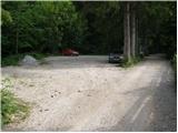
From the Ljubljana - Jesenice motorway we take the Lipce exit (or Hrušica) and continue towards Jesenice, where signs for Planina pod Golico direct us onto the ascending road (the junction is marked and located near the health centre in Jesenice). The relatively steep road soon leads us to the mentioned village, where in May we can admire the flowering of narcissi in the surrounding meadows. From Planina pod Golico we continue to the next junction, where we see numerous hiking signposts. Here we continue right and drive another good 50 m to the parking area below Savske jame.
Route description:
From the parking area we continue along the road, beside which we notice signs for Golica and the Savske jame toboggan run (if we return a few steps from the parking area, the path leads past Kmečki turizem Betel).
After 10 minutes of walking the toboggan run and one of the marked paths towards Golica turn left and begin to ascend more steeply from Korlnov rov. We continue straight and keep ascending along the wider road that runs beside Črni potok.
The path then brings us to a junction where we cross another road and continue straight in the direction of the marked path towards Golica. We then ascend along a poorer and at times quite overgrown cart track. Some 10 minutes higher we cross the road once more (if we continue left along it we reach the lower station of the freight cableway leading to Koča na Golici; to the right we return to the starting point). After the road we also cross a pasture fence and then step onto the grassy slopes of Markljev Rovt, where a few private houses stand.
At Markljev Rovt the path forks. We take the left trail (slightly right leads towards Struška).
Above the rovt the path enters the forest, where it soon crosses a small sandy gully that requires a little more caution. Through the forest we then ascend to the next road, where we continue left (right Pusti Rovt).
We walk along the road for only a few minutes and already reach the marked junction at Sedlo Suha. From there we head in the direction of the ridge path to Golica (the lower path leads to Koča na Golici; sharply right a marked path branches off towards Sedlo Kočna, from where it is also possible to reach Ptičji vrh, Struška and Stol).
The path ahead begins to ascend quite steeply along the grassy eastern ridge of Mala Golica. Higher up the path levels out somewhat and bypasses the highest point of the mentioned summit on the left, Slovenian side. We then return to the ridge and continue with fine views.
Higher up the path once more moves away from the ridge onto the southern slopes, where we also bypass the summit of Krvavka (1784 m) on the left side, then descend slightly for a while and reach the saddle between Golica and Krvavka.
We continue along the marked path, which a little further on is joined by the usual path that leads past Koča na Golici. Along it we then reach the 1835-metre-high summit in the Karavanke in 15 minutes of increasingly scenic walking.
Descent is possible along the shorter, usual path.
Starting point - Korlnov rov 0:10, Korlnov rov - Markljev Rovt 0:50, Markljev Rovt - Sedlo Suha 0:35, Sedlo Suha - junction on Golica ridge 1:05, junction on Golica ridge - Golica 0:15.

Photos:
 1
1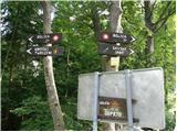 2
2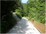 3
3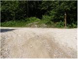 4
4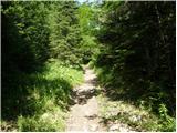 5
5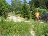 6
6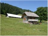 7
7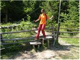 8
8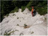 9
9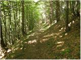 10
10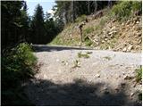 11
11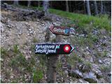 12
12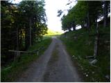 13
13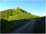 14
14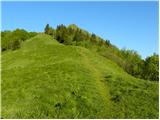 15
15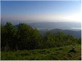 16
16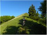 17
17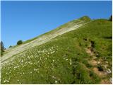 18
18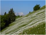 19
19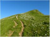 20
20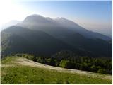 21
21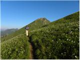 22
22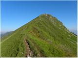 23
23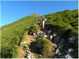 24
24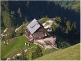 25
25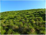 26
26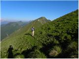 27
27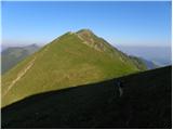 28
28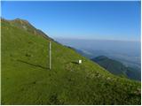 29
29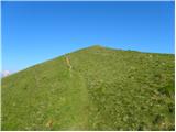 30
30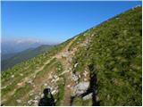 31
31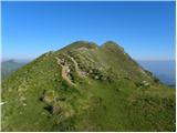 32
32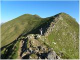 33
33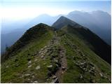 34
34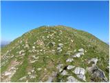 35
35 36
36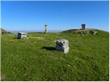 37
37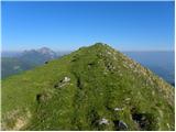 38
38 39
39
Discussion about the trip Planina pod Golico (Betel) - Kahlkogel/Golica (via Suha saddle)
|
| Gost26. 04. 2007 |
it will look nice
|
|
|
|
| Gost2. 05. 2007 |
Recently we were on Golica and I can say it's wonderful. Nicely arranged and marked path, although quite steep and quick ascent. But everything is rewarded with a wonderful view at the top. Narcissi are not blooming yet, but soon they will and then it will be very nice. I RECOMMEND.
|
|
|
|
| irena.lamot3. 05. 2007 |
On 28 April narcissi were already blooming on Planina pod Golico and under Mala Golica the flowers were already boldly opening. The path is beautiful but steep (but not as much as Betel - Golica). I don't agree that the path is well marked, as we were in doubt several times if we were on the right path. Walking time from Planina pod Golico, over Sedlo Suha, Mala Golica, Krvavko and then to Golica is less than 4 hours with stops for photos and rest. Views are beautiful - Triglav and Austrian Carinthia. Worth a visit!
|
|
|
|
| Gost28. 05. 2007 |
I'm interested when the WINTER PATH to Golica was newly marked. Regards
|
|
|
|
| Gost16. 08. 2007 |
We were thinking of approaching Golica from Stol, so I'm interested in what the path along the ridge is like and how long it is. I'm sure someone has already hiked it, so I politely ask for information. Thanks and best hiking greetings to ALL!
|
|
|
|
| keber16. 09. 2009 |
This path is very poorly marked, if someone goes on this path for the first time they can easily stray onto another path, moreover threats with a vicious bull in three languages on the intermediate pasture (empty!) somehow don't belong on hiking trails, so as if the farmer doesn't like people walking across his property.
|
|
|
|
| Majdag5. 05. 2011 |
...Daffodils along the ridge from Suha saddle towards Krvavka, or rather Golica are already there. White meadows and intoxicating scent accompany you for quite a while. There are still many unbloomed ones, so this beauty will last another ten days or so. On Markljev rovtu you can pick dandelion flowers, best regards ...Majda
|
|
|
|
| temba30. 08. 2011 |
We walked the path with my husband on Saturday and it's really not well marked. But the right direction can be found. When going straight from the road through the forest, follow the signpost pointing to Nepomukov kot. When crossing the pasture with the scary bull that isn't there (nor any other livestock, as the pasture is empty ), you need to turn left uphill, past the barn. We went right, along the gully on the pasture and then came back to the road, which we then followed to sedlo Suha. This just shortened the path a bit for us. I think the path described here is nicer to walk than the one past Betla and Fenc, which is quite torn up. And the views are better too. ), you need to turn left uphill, past the barn. We went right, along the gully on the pasture and then came back to the road, which we then followed to sedlo Suha. This just shortened the path a bit for us. I think the path described here is nicer to walk than the one past Betla and Fenc, which is quite torn up. And the views are better too.
|
|
|
|
| Edina2. 04. 2014 |
On Monday from the hut on Golica I was figuring out that maybe from the saddle Suha one could get via Mala Golica to Krvavka. Today I started at Planina pod Golico and via Markljev Rovt to saddle Suha. The first steep part at the saddle I did still with snowshoes, continued without. On the ridge on our side there are some snow tongues that can be bypassed, on Krvavka it's advisable to turn back until nature does its work. More http://stezeinsledi.blogspot.com/
|
|
|
|
| dzuko28. 09. 2014 |
Today, on 28.09.2014, on the path from Planina pod Golico to the summit and down to sedlo Suha and back to Planina pod Golico, I lost black car keys without a keychain - Alfa Romeo. If anyone finds them, please notify me. Thank you!
051 228 714
luka.modic@gmail.com
|
|
|
|
| dkrajnc2714. 05. 2016 |
Hello
On Wednesday 18.5 I plan to take the mentioned path, if anyone wants to see the narcissus, contact me at taxxi3@gmail.com
|
|
|
|
| Hribolazec8115. 05. 2016 |
dkrajnc27 if I get leave I'll contact you
|
|
|
|
| ločanka19. 05. 2016 |
The path is really not well marked, you're in doubt if you're even on Markljev rovt, where actually. We two missed it, we crossed the planina towards the east and arrived too early on that road that comes from Pusti rovt and thus extended the path. Then on that road we saw which path we should actually have taken. So correctly it would be, at least I think, to cross the planina towards the north, there among the buildings somewhere.
|
|
|
|
| golica16. 05. 2018 |
Regarding Ločanka's comment, is the path from Markljev Rovt now better marked? If not, where above that hut (not quite a hut) do you head to reach the saddle up there, I was there last year but don't remember exactly:Thanks
|
|
|
|
| Majdag16. 05. 2018 |
At Markljev Rovt, behind the fence there is a nice sign with a drawn narcissus, for Golica. Follow the path and you reach a forest road. Walk left along the road for a while and you are at Suho sedlo. Then just up towards Mala Golica. Good luck!
|
|
|
|
| Toni-k16. 05. 2018 |
When you come through the woods to Markljev rovt, immediately turn left up the grass slope, after some 10 m you spot a path and this after approx. 100 m turns left again into the forest, through the fence,, there you turn right towards the north where you see the path ahead towards the Suha saddle
|
|
|
|
| golica16. 05. 2018 |
Excellent, I think there won't be problems. Just this part I didn't quite remember. Many thanks
|
|
|
|
| golica17. 05. 2018 |
to report, marking is excellent, as said, if you follow it, you can't miss.
|
|
|
|
| DLteam12. 10. 2018 |
The path description should be gradually refreshed... That is... When you reach the crossroads via the mining path, keep right where the forest road is covered with a few meters of new asphalt. The mentioned asphalt turns to gravel, then soon another crossroads, the path directs left on a normally drivable gravel road. We follow this road for some time, then reach Markljev Rovt. From here things become more or less simple.
I'd add that this path is really super, as you quickly reach the scenic ridge and climb towards Golica for quite some time on really wonderful scenic slopes... Return via the hut on Golica to make a wonderful circular tour.
|
|
|
|
| jvali17. 05. 2020 |
DLteam, thanks for the last comment and the note in the last paragraph...that's exactly what I wanted to ask, how to make a nice loop and walk most of the time on the scenic ridge? I've been to Golica before, but then with school hikers and we adapted to them, of course, now I'd like something new for myself. I'll pin this "sausage".
|
|
|
|
| Enka17. 05. 2020 |
Hurry up, as soon as possible, the narcissuses on the ridge are in full bloom!
|
|
|
|
| jvali18. 05. 2020 |
Enka, thanks, this week, on Thursday I have a burning desire, and may the weather be "just right" too.
|
|
|
|
| garmont18. 05. 2020 |
Personally, walking on macadam doesn't suit me at all.
If you go up the described trail, you have it for almost an hour. And cars drive by...
|
|
|
|
| golica9. 05. 2022 12:50:37 |
I know that under Golica(Krkavka...Ptičji vrh) there are no narcissus yet, what about Plavški rovt, are there maybe?
thanks
|
|
|
|
| Jusk9. 05. 2022 14:19:52 |
Under Španov vrh there are already quite a few, otherwise for now more buds than flowers, but in Plavški rovt they are already nicely blooming. Regards
|
|
|
|
| golica9. 05. 2022 19:53:14 |
super, thanks
|
|
|
To post a comment you must log in:
If you do not yet have a username, you must first
register.